
Imhade P. Okokpujie* | Muhammad I. N. Ma'arof | Rajneesh K. Singh
© 2026 The authors. This article is published by IIETA and is licensed under the CC BY 4.0 license (http://creativecommons.org/licenses/by/4.0/).
OPEN ACCESS
Rainfall-induced slope failures and landslides are significant geotechnical hazards that threaten human life, infrastructure, and environmental sustainability globally. Due to their ability to model complex nonlinear relationships among hydrological, geological, and environmental factors, machine learning (ML) techniques have shown potential for predicting and assessing slope instability in recent years. This paper presents a systematic literature review of ML applications for rainfall-induced slope stability analysis, using the Preferred Reporting Items for Systematic Reviews and Meta-Analyses (PRISMA) methodology. Overall, 120 studies were reviewed and analysed during 2015-2026 to identify dominant research trends, commonly used algorithms, data sources, performance metrics, and technological development. These results show that the most prevalent ML techniques are Artificial Neural Network (ANN), Support Vector Machine (SVM), Random Forest (RF), and XGBoost, and that ensemble learning techniques, in general, are widely used compared to other techniques in predictive performance. The review also highlights the growing use of ML alongside geographic information systems (GIS), remote sensing technologies, numerical geotechnical models, Explainable Artificial Intelligence (XAI), and digital twin frameworks. The bibliometric analysis revealed that the volume of publications has significantly increased over the last decade, indicating growing interest in intelligent approaches to landslide prediction and risk management. Although there is considerable progress, problems with data quality, model interpretability, transferability, and real-time deployment still exist. It is recommended that future developments be built upon hybrid, explainable, and physics-Informed ML models that will enable the creation of autonomous and resilient slope-monitoring systems. This study aims to compile all available and valuable information in one place for other researchers and engineers who are involved in landslide hazard assessment and geotechnical risk management.
rainfall-induced slope stability, machine learning, landslide susceptibility assessment, geotechnical engineering, infrastructural development
Slope failure is one of the most common and severe geohazards worldwide and is responsible for loss of life, infrastructure destruction, ecosystem degradation, and significant economic losses caused by rainfall. While the rain persists or is heavy enough for a long time, the rainwater can penetrate into soil masses, leading to an increase in soil moisture and the pore-water pressure of the soil, a decrease in matric suction and effective stress, and a corresponding decrease in the shear strength of soil slopes [1]. Over time, these hydrological and geotechnical conditions can cause slopes to become increasingly unstable, eventually leading to landslides or other slope failures. With the warming climate and increasingly harsh, erratic precipitation patterns, coupled with high rates of urbanisation, deforestation, land-use change, and infrastructure construction, rainfall-induced slope failures are of increasing concern in many areas [2]. Therefore, understanding the mechanisms that control rainfall-induced slope instability is an important aspect of Disaster Risk Reduction, Geotechnical Hazard Assessment, and Resilient Infrastructure Planning. The interaction among the various factors involved in rainfall-induced slope failure, namely rainfall characteristics, infiltration, pore-water pressure, soil properties, terrain, vegetation, and anthropogenic factors, further complicates the prediction of rainfall-induced slope failure [3].
For infrastructure projects situated on natural or engineered slopes, slope stability assessment is crucial for planning, design, construction, operation, and slope management [4]. Both deterministic and probabilistic methods have traditionally been used to evaluate slope stability, with soil strength, unit weight, slope geometry, groundwater conditions, and rainfall characteristics as parameters for calculating the factor of safety (FoS) or the probability of failure. Traditional methods of analysis and numerical modelling, such as the Limit Equilibrium Method (LEM), Finite Element Method (FEM), and Finite Difference Method (FDM), have made significant contributions to understanding and predicting the behaviour of slopes [5].
However, the spatial variability and uncertainty in soil and rock properties, rainfall infiltration, groundwater conditions, boundary conditions, and failure mechanisms can affect the reliability of these approaches [6]. Physical models of landslides occurring as a consequence of rainfall can be useful to gain insights into hydro-mechanical processes controlling landslide instability, but they are typically difficult to apply, especially at a regional scale, due to data requirements, such as detailed geotechnical, hydrological, geological, and topographical data, which may not be available on a consistent basis [7]. They may also be constrained in their use of large and complex slope systems due to computational needs, parameter calibration, model uncertainty, and difficulties in representing heterogeneous field conditions [8].
This has led to growing interest in data-driven methods, including machine learning (ML), for analysing and forecasting rainfall-induced slope instability. ML algorithms can learn from past and observed data to determine complex non-linear relationships among governing variables, a capability not possible with traditional methods, which typically rely on explicit assumptions about those relationships. This is an important capability in the context of rainfall-induced slope problems, as slope response is governed by interactions among a variety of factors: rainfall intensity and duration, antecedent rainfall, soil and rock properties, terrain morphology, groundwater conditions, land cover, and anthropogenic activity. In the past two decades, the applications of algorithms like Artificial Neural Network (ANN), Decision Trees (DT), Random Forest (RF), Support Vector Machines (SVM), Gradient Boosting approaches, and Extreme Gradient Boosting (XGBoost) have become more and more common in slope stability and landslide prediction problems, respectively [9]. With the growing availability of increasingly large datasets derived from geotechnical investigations, remote sensing, geographic information systems (GIS), digital elevation models (DEMs), rainfall observations, and slope-monitoring systems, the potential for ML to support geotechnical hazard assessments has been further strengthened.
An important difference, however, should be noted: rainfall-induced landslide research applications are not a single prediction problem but a number of them. Based on the different goals of prediction, spatial and temporal scales, and engineering goals, these can be categorised into four interconnected yet distinct application domains. The first domain is the prediction of slope-scale stability and factors of safety, where ML models are used to predict FoS, assess slope stability or instability, or approximate the results of traditional stability analysis. This application primarily focuses on the engineering evaluation of a specific slope or a defined slope system. The second domain is regional landslide susceptibility mapping, in which ML models integrate rainfall, topographic, geological, environmental, and anthropogenic data, as well as GIS and remote sensing data, to assess the spatial probability of landslide occurrence [10]. Susceptibility mapping focuses on the spatial distribution of landslide susceptibility across a landscape, rather than the mechanical stability of a particular slope, and is therefore not the same as FoS prediction.
The third domain is the prediction of slope displacement and deformation, which addresses the temporal behaviour of slopes using monitoring data, including displacement, deformation, rainfall, pore-water pressure, and other time-dependent measurements. The use of ML techniques can help detect temporal patterns and predict future movement on slopes, thereby aiding in the monitoring and assessment of slope deformation. The fourth domain concerns rainfall-induced landslide forecasting and warning, in which ML models are built to detect temporal conditions that increase landslide risk and to provide information to support timely decision-making for warning and risk management [11]. These four domains are very similar, but are not synonymous. The mechanical stability at the slope scale is predicted by FoS prediction, spatial patterns of hazard by susceptibility mapping, temporal deformation behaviour by displacement prediction, and early-warning models for forecasting impending or near-term hazard conditions. Thus, they have various input variables, output variables, datasets, spatial and temporal resolutions, validation strategies, and applications.
This difference is crucial when assessing the reported performance of ML models. A laboratory-based model used to predict FoS cannot be compared with a susceptibility model based on remotely sensed and GIS variables at the regional scale, or with the model predicting slope displacement over time, or with the early-warning model based on rainfall. Likewise, a high predictive accuracy in one application domain doesn't necessarily mean that the model can be transferred to another spatial or temporal scale. The size and quality of a dataset, class imbalance, representation of rainfall, feature selection, spatial and temporal dependence, model calibration, uncertainty, and validation strategy can significantly impact performance reported [12]. Therefore, a systematic evaluation of ML applications should take into account, in addition to the best-performing algorithm, the type of prediction, the scale of the prediction, the data type, rainfall, the geotechnical conditions, and the purpose of the engineering or disaster-management application.
Previous reviews have successfully analysed the current state of the art in ML for slope stability, landslide susceptibility prediction, landslide prediction, and early-warning applications. Previous review studies have focused on the development of ML approaches to slope stability and landslide-of-safety (LOS) prediction, and other reviews have focused on ML- and GIS-based landslide susceptibility mapping. Other reviews have also examined the use of ML in landslide monitoring, prediction, prevention, and early-warning systems. The contributions illustrate the increasing role of a data-driven approach in managing geotechnical hazards. However, the current literature is rather disjointed with respect to the application domain and to the analysis of slope stability, susceptibility, displacement prediction, and early warning, whether treated separately or within a broader landslide-hazard context [13]. Therefore, a systematic synthesis is still needed that specifically addresses the application of ML to the prediction of rainfall-induced slope instability, covering a range of geospatial prediction domains, and taking into account differences in data sources, prediction objectives, spatial/temporal scales, model architectures, model validation procedures, and integration with physically based approaches.
Moreover, the emergence of hybrid and intelligent modelling solutions has introduced new opportunities and methodological challenges. Hybrid approaches in which physically based geotechnical or hydrological models are coupled with ML algorithms have been shown to effectively enhance prediction reliability by integrating both physical knowledge and pattern-recognition capabilities [14]. Likewise, the incorporation of ML into remote sensing, GIS, Internet of Things (IoT)-based monitoring, Digital Twin, and real-time rainfall observation is developing ever more complex solutions for monitoring and forecasting of hazards on slopes. There are, however, questions to be addressed regarding the interpretability of the models, uncertainty quantification, data needs, generalisation across geological and climatic environments, transferability between sites, and the potential to use data-driven models in tandem with, but not in place of, traditional geotechnical models. For practical engineering applications such as these, it is critical that model predictions are reliable, interpretable, and robust enough for use in safety-critical decision-making.
Considering the above, this study is a systematic literature review based on the Preferred Reporting Items for Systematic Reviews and Meta-Analyses (PRISMA) guidelines, which will comprehensively cover the development and application of ML for rainfall-induced slope instability. The literature is reviewed in a systematic fashion and organised into four major application areas: (i) factor-of-safety and slope-stability prediction, (ii) regional landslide susceptibility mapping, (iii) slope displacement and deformation prediction, and (iv) rainfall-triggered landslide forecasting and early-warning systems. In these aspects, the review covers the number of publications, geographical spread, predictors of precipitation (rainfall and geotechnical), precipitation data sources, ML algorithms, model architectures, evaluation metrics, and reported predictive performance. The differences between application domains are highlighted, and in particular, the impact of data characteristics, spatial and temporal scales, and data-validation dimensions on the model performance is discussed [15].
The review also examines new hybrid physics–ML methods and methodological challenges related to data availability and uncertainty, interpretability, transferability, and real-world implementation. Instead of expecting a single ML algorithm to be best for all rainfall-induced slope instability problems, this study aims to develop a structured understanding of when each ML algorithm is most suitable for each such problem [16]. The results will provide researchers and geotechnical practitioners with an evidence-based toolkit to understand the state of the art in ML applications, recognise persistent research gaps, and inform the design of more reliable, interpretable, and physically sound data-driven tools for rainfall-induced slope stability assessment and landslide risk management. The aim of the study is to systematically review literature on ML for rainfall-induced slope stability and landslide susceptibility. In order to achieve the aim, the study has the following objectives, which are to:
1. Carry out a systematic review of the application of ML in rainfall-induced slope stability analysis.
2. Find out the most used ML algorithms and assess their performance for the prediction of slope stability and landslide susceptibility.
3. Identify the research gaps for Rainfall-Induced Slope Stability and Landslide Susceptibility.
1.1 Statement of the problem
Many communities around the world remain at risk from rain-induced landslides, which can threaten life, property, and the environment. The number of extreme precipitation events has also increased due to climate change, intensifying the frequency of slope failures and further increasing the importance of prediction and hazard assessment. Although major progress has been made in geotechnical engineering, predicting rainfall-induced slope instability is a complicated problem [17]. This is because many factors that affect slope failure are interdependent, including rainfall intensity and duration, soil properties, geologic factors, groundwater dynamics, vegetation, and anthropogenic activities.
The LEM, FEM, and FDM are widely used in engineering practice for assessing slope stability. These approaches have been shown to be useful tools for understanding slope behaviour, but they often rely on simplifying assumptions and require a high level of site-specific information that is not always available [18]. Additionally, the complex and stochastic behaviour of rainfall-induced slope failures may make traditional analytical and numerical failure models less predictive, especially in large-scale or data-rich settings.
However, in the past few years, ML techniques have proven valuable tools and potential alternatives to traditional approaches for predicting slope stability, owing to their ability to learn complex patterns from vast amounts of data and model nonlinearities without the need for physical models. Therefore, many studies have used ML techniques such as ANNs, SVMs, RF, DT, and XGBoost to predict rainfall-induced landslides [19]. The current literature, however, is quite heterogeneous across datasets, input parameters used, model architectures, validation approaches, and performance evaluation metrics.
This fragmentation has made it difficult to determine the most successful machine-learning techniques, the factors that affect model performance, and the best practices for rainfall-induced slope stability analysis. In addition, thorough and updated systematic reviews that incorporate trends in the literature, methodological innovations, model performance evaluations, and promising directions for research within a single study have not yet been published, and research in this area continues to grow. It is therefore essential to conduct a systematic literature review to synthesise existing knowledge, identify gaps, and suggest directions for future studies on slope stability assessment using ML approaches.
To address the research gaps above and achieve the objectives of this study, the following research questions have been formulated:
RQ1: What ML techniques are mostly used for rainfall-induced slope stability analysis?
RQ2: What data sources, input parameters, and performance evaluation measures are commonly used in ML-based slope stability studies?
RQ3: How effective is ML when compared with conventional geotechnical methods for rainfall-induced slope stability prediction?
RQ4: What are the main research gaps, challenges, and future benefits in the application of ML to rainfall-induced slope stability analysis?
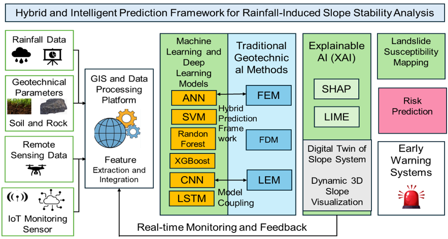
Therefore, the current study developed a conceptual framework diagram (Figure 1) showing how the technologies mentioned (ML-GIS, deep learning, Explainable Artificial Intelligence (XAI)) could be used for rainfall-induced slope stability prediction. Also, the conceptual framework illustrates the pattern of the current study.
Figure 1. Intelligent hybrid framework for rainfall-induced slope stability prediction
2.1 Research design
This study used a systematic literature review methodology based on the PRISMA 2020 framework to enhance transparency, reproducibility, and methodological rigour. Using the PRISMA approach, relevant studies were identified, screened, assessed for eligibility, and systematically included, thereby reducing the risk of selection bias and improving the reliability of evidence synthesis [20].
2.2 Reference management and database search strategy
An electronic database-specific search strategy was created for each electronic database, with modifications to the search strategy syntax and searchable fields as needed. Web of databases were searched in Scopus, Web of Science, Dimensions, and Google Scholar. The title, abstract, and keywords were the main headings in the search fields provided by each database [21]. All retrieved records were downloaded in formats compatible with reference-management software, such as Excel and mybib.com, for accurate extraction and citation, and then imported to identify and eliminate duplicates. Relevant Google Scholar records were chosen and screened according to the pre-established inclusion criteria. The other records were screened by the title/abstract and then by the full text. For the database search strategy and screening process, the authors provide a presentation in Table 1 to ensure transparency, and the same procedure can be reproduced.
Table 1. The concise search strategy for the study
|
Database |
Fields Searched |
Search Approach |
Export Format |
Number of Documents Searched from the Database |
|
Scopus |
The Boolean operators and the Keywords were used. |
TITLE-ABS-KEY(("rainfall-induced landslide" OR "rainfall triggered landslide" OR "rainfall-induced slope instability") AND ("machine learning" OR "artificial intelligence" OR "deep learning" OR "artificial neural network" OR "random forest" OR "support vector machine" OR "decision tree" OR "XGBoost") AND ("slope stability" OR "factor of safety" OR "landslide susceptibility" OR "early warning")) |
CSV/Excel |
N = 308 |
|
Web of Science |
Topic (Title, Abstract, Keywords with Boolean operators) |
TS=(("rainfall-induced landslide" OR "rainfall triggered landslide" OR "rainfall-induced slope failure" OR "rainfall-induced slope instability") AND ("machine learning" OR "artificial intelligence" OR "deep learning" OR "artificial neural network" OR "random forest" OR "support vector machine" OR "decision tree" OR "XGBoost") AND ("slope stability" OR "factor of safety" OR "landslide susceptibility" OR "landslide prediction" OR "early warning")) |
RIS/Excel |
N = 256 |
|
Dimensions |
Title, Abstract, Keywords |
("rainfall-induced landslide" OR "rainfall-induced slope failure" OR "rainfall-triggered slope failure") AND ("machine learning" OR "artificial intelligence" OR "deep learning" OR "neural network" OR "random forest" OR "support vector machine" OR "gradient boosting" OR XGBoost) AND (slope stability" OR "landslide susceptibility" OR "landslide prediction" OR "landslide forecasting" OR "landslide early warning") |
RIS/Excel |
N = 235 |
|
Google Scholar |
Title/sub-title relevance |
“Machine Learning Algorithms Applied in Rainfall-Induced Slope Stability Analysis” and “Hybrid and Intelligent Prediction Study” |
Google Scholar reference style / RIS |
N = 446 |
2.3 Inclusion and exclusion criteria
The studies focused on were only those published in the last 12 years (from 2015 to 2026) to reflect recent advancements in the applications of ML in geotechnical engineering. Only English-language journal articles published were peer-reviewed and taken into account.
Studies were selected for review using clear eligibility criteria to ensure the review of studies was relevant and of high quality. The inclusion criteria were:
1. Research on rainfall-induced slope stability or landslide susceptibility.
2. Research that used ML/artificial intelligence methods.
3. Peer-reviewed journal articles published between 2015 and 2026.
4. Studies with model performance metrics or validation results.
5. Studies that are available in full-text format.
Likewise, the exclusion criteria were:
1. Studies not related to rainfall-induced slope failures.
2. Papers that do not involve ML or data-driven methods.
3. Conference abstracts, editorials, and book chapters without sufficient methodology.
4. Studies that are not available in full-text form.
5. Duplicate publications across databases.
2.4 The Preferred Reporting Items for Systematic Reviews and Meta-Analyses method employed
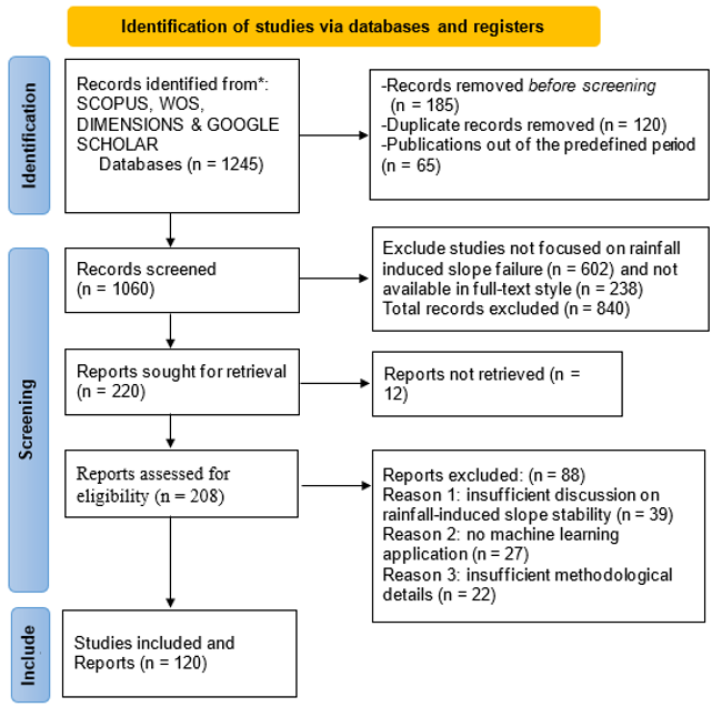
The study process was divided into the four steps of the PRISMA guideline for conducting a study: identification, screening, eligibility, and inclusion, as shown in Figure 2 [22].
Figure 2. Preferred Reporting Items for Systematic Reviews and Meta-Analyses (PRISMA) flow diagram for the study
2.5 Screening process, data extraction procedure, and quality assessment
The screening process was conducted in two stages. The first step was a title and abstract screening, and studies irrelevant to the topic were excluded. This narrowed the dataset from 1,060 to 220 studies. In the second phase, full-text screening was conducted to identify articles that were methodologically relevant, had high-quality datasets, and met their research goal. An application of these criteria excluded 88 studies, and 120 studies were included in the systematic review. Therefore, two independent reviewers applied the prespecified inclusion and exclusion criteria to the identified records for the study-selection process. Two types of screening were used: title and abstract screening and full-text assessment. The reviewers made their own decisions about the eligibility of the studies and did not influence each other. In cases of disagreement, the reviewers discussed the rationale for their decision and tried to resolve the disagreement. When it was not possible to reach an agreement, a third reviewer (one of the authors) was consulted for the final decision. Data extracted comprised the authors' names, the year of publication, the geographical location, data source, size of the data set/sample size, application to landslides or slope stability, machine-learning algorithm used, predictor variables, rainfall-related variables, and data-preprocessing methods, training data and testing procedures, validation design, performance metrics, external testing, major findings, limitations, and reported research gaps.
Table 2. The quality criteria assessment questions applied to the systematic review
|
Quality Criterion |
Assessment Question |
|
Dataset source |
Are the source and origin of the rainfall, landslide, geotechnical, topographic, remote-sensing, or other input datasets clearly identified and adequately described? |
|
Sample size |
Is the number of observations, landslide inventories, slope records, pixels, or samples provided? |
|
Validation design |
Does the study clearly describe the training, validation, and testing strategy, including cross-validation? |
|
External testing |
Was the developed machine learning (ML) model tested on an independent dataset, in a separate geographical area, or during a different period? |
|
Reporting quality |
Are the ML methodology, input variables, preprocessing, model configuration, performance metrics, and experimental procedures sufficiently reported to support interpretation and reproducibility? |
In addition to the five domains used to assess the methodological quality of the included studies, the study added a five-domain quality-appraisal checklist covering dataset source, sample size, validation design, external testing, and reporting quality of the included machine-learning studies. The five domains were then used to assign a descriptive quality assessment process in Table 2. The findings from the appraisal were included in the study and used to interpret evidence regarding the performance and generalizability of ML models for rainfall-induced slope stability and landslide susceptibility.
2.6 Data analysis techniques
The descriptive analysis was carried out using VOSviewer version 1.6.20. The analysis was done using full counting. The bibliographic data were pre-processed prior to network construction, eliminating duplicate records and normalising keyword terms. Synonymous terms, spelling deviations, abbreviations, and alternative expressions were combined using a thesaurus file. The co-occurrence analysis was conducted excluding words that appeared fewer than 5 times. The keyword co-occurrence network was created by normalising associations by strength, and clustering was done with the VOS clustering technique (VOSviewer) with a resolution parameter of 1.00. Author-name variants were collated, with any differences arising from initialisation, spelling, or names being minimised to reduce fragmentation of author collaboration networks. The networks were then visualised and interpreted based on cluster composition, link strength, frequency of occurrence, and thematic relationships.
The use of ML in rainfall-induced slope stability analysis has evolved from a relatively unknown research area into an expanding interdisciplinary field that integrates geotechnical engineering, hydrology, remote sensing, and artificial intelligence. To study ML techniques and their performance, it is essential to first understand the fundamental processes governing rainfall-induced slope failure. These processes involve infiltration of rainwater, development of pore-water pressure, reduction in the shear strength of a slope, and complex interactions among geological, hydrological, and environmental processes that affect slope behaviour. These concepts form the physical underpinning for the development of modern data-driven prediction models. Thus, this section reviews the basic mechanism of rainfall-induced slope failure, the key factors, and the problems in predicting and monitoring slope failure.
3.1 Rainfall-induced slope stability analysis: Concepts and challenges
In unsaturated soils, where matric suction can significantly contribute to apparent cohesion, precipitation infiltration has been shown to be the most important factor in triggering both shallow- and deep-seated landslides. When rainfall enters the soil profile, suction slowly decreases, causing effective stress and shear strength to decline as well, potentially leading to failure [23].
In addition, data from monitoring systems may be large-scale and of various types, such as rainfall, piezometric, remote sensing, and deformation monitoring data. The lack of integration of these various data sources to build powerful predictive systems is a major challenge. Advanced data-driven methods that address uncertainty and high-dimensional data have therefore been proposed recently, leading to the growing use of ML methods in rainfall-induced slope stability analysis [24]. The main factors affecting rainfall-induced slope failure are summarised in Table 3, along with typical qualitative effects reported in recent studies.
Table 3. Selected summary of literature on some factors influencing rainfall-induced slope failure
|
Representative Studies |
Specific Factors |
Ranges Reported in Selected Studies |
Geographic Setting |
Soil / Geological Setting |
Time Scale |
Influence on Stability / Landslide Prediction |
|
Roccati et al. [25] |
Rainfall intensity, rainfall duration, and cumulative rainfall |
Site-specific intensity–duration thresholds 20–150 mm/h |
Portofino Promontory, Liguria, Italy; Mediterranean climate |
Mediterranean coastal geological and geomorphological setting; shallow landslide-prone slopes |
1910–2019 rainfall record; individual rainfall events |
Increasing rainfall intensity, particularly for shorter durations, increases the likelihood of shallow-landslide initiation; the threshold is strongly site-dependent |
|
Mondini et al. [26] |
Cumulative Rainfall |
Daily cumulative rainfall; SIGMA thresholds based on statistical distribution 100–300+ mm |
Italy, regional landslide-prone mountainous areas |
Regional mountainous terrain and shallow-landslide environments |
2002–2020; hourly observations; forecasts from 1–24 h |
Rainfall history contains sufficient information for deep-learning prediction of rainfall-induced shallow landslides |
|
Abraham et al. [27] |
Cumulative rainfall, antecedent rainfall, and rainfall duration |
Daily rainfall and cumulative rainfall over 1–365 days |
Kalimpong, Darjeeling Himalayas, West Bengal, India |
Himalayan mountainous terrain; shallow, rapid, and deep-seated landslide environments |
2010–2015 calibration; 2016–2017 validation |
Longer cumulative rainfall windows capture antecedent wetness and improve rainfall-triggering thresholds and warning capability |
|
Nair et al. [28] |
5-day cumulative rainfall; 7-day cumulative rainfall; rainfall threshold; slope gradient; land use; lithology; vegetation |
Approximately 300 mm/5 days and 500 mm/7 days are associated with landslide |
Konnathady and Vellathooval, Idukki District, Kerala, India |
Precambrian crystalline rocks; weathered formations; clay-loam/clay soils |
Primarily 2018 extreme rainfall event; 5-, 7-, and 10-day |
Antecedent rainfall strongly controls landslide initiation; local thresholds depend on terrain, soil, geology, vegetation and land-use conditions |
|
Menon and Kolathayar [29] |
Rainfall intensity; rainfall duration; cumulative rainfall; antecedent rainfall; ML-derived rainfall thresholds |
Rainfall was evaluated in antecedent periods, up to 15 days before landslide occurrence |
Kerala, India; Western Ghats / tropical monsoon environment |
Landslide-prone tropical terrain; heterogeneous geological and soil conditions |
64 landslide events since 2000; rainfall history up to 15 days before events |
ML can identify nonlinear relationships between rainfall characteristics and landslide occurrence and complement empirical thresholds |
|
Ma et al. [30] |
Rainfall infiltration; hydraulic conductivity; soil water retention; void ratio; soil strength; spatial variability |
Variable soil properties; numerical rather than field-derived universal ranges |
Synthetic numerical slope; no specific geographic field site |
Unsaturated soil with spatially variable void ratio and hydraulic/mechanical properties |
Transient rainfall simulation |
Spatial variability of soil properties and void ratio affects infiltration, pore-water response and rainfall-induced failure |
|
Zhou et al. [31] |
Rainfall intensity; slope inclination; soil-rock ratio; water content; pore-water pressure; earth pressure |
Rainfall intensity 23.60, 34.20 and 58.70 mm/h; slope angles 30° and 40°; soil-rock mixture ≈ 23% rock |
Three Gorges Reservoir area, China |
Soil-rock mixture slope |
Controlled rainfall experiments during rainy-season conditions; event/model-test scale |
Increasing rainfall intensity and slope inclination increase water content, pore-water pressure and failure severity |
|
Naidu et al. [32] |
Daily rainfall; antecedent rainfall; rainfall threshold; slope stability/FoS; soil parameters |
2-, 3-, and 5-day antecedent rainfall evaluated against daily rainfall |
Amboori, Kerala, India; Western Ghats |
Shallow landslide-prone tropical slopes |
Rainfall-event scale; multi-day antecedent rainfall |
Increasing antecedent rainfall reduces the additional rainfall required to trigger instability; it supports rainfall-based early warning |
|
Ebrahim et al. [33] |
Rainfall intensity; rainfall duration; cumulative rainfall; antecedent rainfall; pore-water pressure; soil moisture; hydraulic response |
Multiple threshold forms; ranges vary considerably among reviewed studies |
Multiple global geographic settings |
Multiple soil, rock and geological environments |
Multiple scales, from individual rainfall events to long-term antecedent periods |
Demonstrates that rainfall-induced landslide thresholds are strongly dependent on climatic, hydrological and geological context |
|
Yang and Hasan [34] |
Rainfall intensity; rainfall duration; slope gradient; slope height; lithology; groundwater; anthropogenic modification |
100 mm/24 h; 250 mm/24 h; 240 mm/72 h rainfall scenarios |
Zhongxin Town, northern Guangdong, China; humid subtropical |
Weathered slopes, unconsolidated sediments, fractured bedrock and human-modified cut slopes |
24–72 h rainfall scenarios |
High intensity/prolonged rainfall combined with steep and anthropogenically modified slopes increases hazard and spatial risk |
|
Badapalli et al. [35] |
Rainfall; vegetation/land cover; geology; elevation; slope; aspect; topography; environmental/anthropogenic factors |
Spatial predictor variables rather than a universal numerical threshold |
Kozhikode District, Kerala, India; Western Ghats |
Precambrian crystalline rocks, weathered formations and lateritic soils |
Regional/spatial susceptibility scale; remote-sensing observation period |
ML-based susceptibility mapping identifies combinations of environmental and terrain factors associated with higher landslide susceptibility |
3.2 Machine learning algorithms applied in rainfall-induced slope stability analysis
Due to uncertainty in hydraulic parameters, spatial variability in soil properties, and the complexity of computing physically based rainfall-infiltration models, researchers have turned to ML techniques as alternatives for predicting slope stability. Traditional approaches rely on explicit physical formulations, which can be circumvented by ML algorithms that learn nonlinear relationships directly from historical observations and environmental datasets. Recent research shows that ML has emerged as one of the fastest-growing fields in landslide susceptibility assessment and rain-induced slope failure prediction, with significant increases in publications since 2018 [36, 37].
ANNs were among the first ML approaches applied to slope stability problems due to their capacity to model highly nonlinear relationships between input variables and failure outcomes. The extensive use of ANN models for landslide susceptibility mapping and rainfall-induced failure prediction has been suggested to approximate complex hydro-mechanical interactions that are hard to model using conventional analytical methods. The prediction accuracy of recent studies has exceeded 85%, and interpretable neural networks have been shown to achieve performance on par with state-of-the-art deep learning models while offering enhanced model explainability. A scalable, interpretable, and high-performing neural network framework was developed by Soltaninejad et al. [38] that was able to recognise the contribution of slope gradient-precipitation interaction to landslide occurrence and predict it with high accuracy in various Himalayan datasets.
SVMs have also received significant attention in rainfall-induced slope stability analysis due to their good generalisation properties and efficiency with limited training samples. SVM-based models work well for high-dimensional classification problems, where non-linear kernel functions can separate stable and unstable slope conditions. In landslide susceptibility applications, the Area Under the Curve (AUC) value of the SVM model is often reported to exceed 0.85 [39, 40]. Lately, SVM variants based on optimisation techniques have been developed to further enhance the predictive power of SVM. As an example, Ajin et al. [41] combined Support Vector Regression with Particle Swarm Optimisation and Grey Wolf Optimisation algorithms, achieving significant improvements in susceptibility prediction compared to traditional implementations. The results suggest that optimisation-assisted SVM frameworks are still relevant despite the emergence of more advanced ensemble and deep learning models.
RF combines predictions from multiple DTs (created via bootstrap sampling and random feature selection) to reduce variance and improve classification. AUC values ranging from 0.85 to 0.95 have been reported in many studies on landslide susceptibility modelling using the RF method [42]. In contrast, in rainfall-induced landslide early-warning systems, RF models consistently outperform many traditional statistical methods, as they can handle heterogeneous geospatial data. More recently, comparisons have shown that RF often outperforms individual DT, thereby providing the advantages of ensemble learning in geotechnical prediction problems [43].
3.3 Data sources, feature engineering and model performance
ML algorithms are increasingly relevant to rainfall-induced slope stability analysis, and it is evident that dataset quality and the effectiveness of feature engineering strategies are crucial [44]. The predictive power of advanced ML models like RF, XGBoost, and deep learning models depends heavily on the quality and variety of input variables used during training. Therefore, the past few years have seen significant focus on finding appropriate data sources, fine-tuning feature selection methods, and developing accurate performance assessment methods [45]. Effective ML slope stability models require not only the selection of an appropriate algorithm but also representative rainfall, geotechnical, topographic, geological, and environmental data that capture the complex mechanisms governing slope failure.
Rainfall datasets are one of the most vital sources of information in rainfall-induced landslide prediction studies. Meteorological stations, satellite-based rainfall products, and reanalysis datasets are commonly used by researchers to access historical rainfall data [46]. Parameters of rainfall include cumulative rainfall, precipitation rate, AR, rainfall duration, and maximum hourly precipitation. Huang et al. [47] found that cumulative and antecedent rainfall are significant factors and among the most influential predictors of slope failure. Satellite-derived precipitation data such as TRMM and GPM are now more useful for regional-scale susceptibility mapping, as they can fill gaps in the spatial coverage of observed rainfall in regions with sparse ground-based monitoring networks [48]. A combination of rainfall, terrain, and geological data has greatly enhanced the predictive accuracy of ML models in various recent studies [49].
Besides rainfall datasets, geotechnical parameters are still important predictors for slope stability assessment. The mechanical resistance of slope materials is directly affected by variables such as soil cohesion, friction angle, bulk density, hydraulic conductivity, porosity, groundwater level, and shear strength [50]. As a result, field- and laboratory-derived variables are often supplemented with remote sensing and GIS variables. Merghadi et al. [51] used geotechnical variables and remotely sensed terrain attributes to significantly improve landslide susceptibility prediction accuracy compared with topographic variables alone. These conclusions were also drawn by Arabameri et al. [52], who demonstrated the utility of multi-source GIS datasets in improving machine-learning-based hazard mapping.
With the increasing size and complexity of ML datasets, feature engineering has become increasingly significant for enhancing model efficiency and interpretability [53]. Feature selection techniques are widely used to remove redundant features, reduce dataset dimensionality, and improve prediction accuracy. Common methods include those like Information Gain, Gain Ratio, Relief-F, Principal Component Analysis (PCA), and Shapley Additive Explanations (SHAP)-based importance ranking. It has been demonstrated recently, however, that feature selection can reduce computational costs without compromising, and even enhancing, predictive performance [54]. Common metrics to assess ML models' performance in rainfall-induced slope stability analysis include Qualitative metrics like Accuracy, AUC, Root Mean Square Error (RMSE), Precision, Recall, and F1-score [55]. Among these metrics, AUC remains one of the most widely reported because it provides a threshold-independent measure of classification performance [56]. Most experiments have shown that ensemble methods and powerful boosting algorithms are generally superior to standard classifiers. RF, XGBoost, LightGBM, and deep learning models often achieve AUC values greater than 0.90 and classification accuracy greater than 90% [57]. Table 4 summarises representative studies for rainfall-induced landslide susceptibility and slope stability prediction using ML. The AUC varies across studies.
Table 4. Descriptive analysis of the performance of machine learning (ML) models applied in rainfall-induced slope stability
|
Study |
Models and Prediction Task |
Dataset Characteristics and Sample Size |
Reported Performance and Validation Method |
Main Findings |
|
Zerouali et al. [58] |
Models: GAN integrated with Binary Greylag Goose Optimisation (bGGO-GAN). Task: Circular failure slope stability classification |
Factors: 6 critical factors (unit weight [UNW], cohesion [COH], friction angle [FRI], slope angle [SLA], slope height [HEI], and pore pressure ratio [PPR]). Sample: 627 slope cases. |
Metrics: Accuracy, Sensitivity (TPR), Specificity (TNR), PPV, NPV, F1 Score. Validation: Split-sample (80% training / 20% testing split). Performance: • bGGO-GAN (Best): Accuracy = 95.0%, Sensitivity = 0.946, PPV = 0.928, NPV = 0.962, F1 = 0.937. |
Combining advanced deep learning (GAN) with a metaheuristic feature selection algorithm (bGGO) yields competitive and highly generalizable predictions. |
|
Mulualem and Mekonnen [59] |
Models: Frequency Ratio (FR) and Weights of Evidence (WoE). Task: Landslide susceptibility mapping (binary classification). |
Area: Mountainous region in Ethiopia. Factors: Curvature, slope angle, aspect, lithology, and rainfall. Sample: 576 landslide polygons (6,304 pixels). |
Metrics: Success Rate and Predictive Rate from cumulative area curves. Validation: Split-sample. Performance: • FR (Best): Success Rate = 89.8%, Predictive Rate = 88.2%. • WoE: Success Rate = 86.5%, Predictive Rate = 84.8%. |
The bivariate statistical FR model outperformed WoE. The high concentration of landslides in the mapped "very high" susceptibility category confirmed the models. |
|
Chen and Li [60] |
Models: Reduced-Error Pruning Tree (Rept), Bagging (BRept), Dagging (DRept), and Real AdaBoost (RRept). Task: Landslide susceptibility mapping |
Area: Nanchuan District, China. Factors: 16 factors (slope, curvature, soil, NDVI, etc.). Sample: 298 landslide events; split into 70% training (209) and 30% validation (89). |
Metrics: ROC AUC, SE, 95% CI, MAE, Wilcoxon signed-rank. Validation: Split-sample. Performance: • RRept (Best): Train AUC = 0.927; Validation AUC = 0.745 (MAE = 0.33). |
Reduced-error pruning trees (RRept) is a highly promising hybrid model that significantly improves the predictive power of the base Rept classifier. |
|
Wei et al. [61] |
Tree-based ensemble models: Random Forest (RF), Adaptive Boosting (AB), Gradient Boosting Decision Trees (GBDT), and Extreme Gradient Boosting (XGBoost). Task: Landslide susceptibility mapping |
Area: Laiyuan County, Hebei Province, China. Factors: 12 conditioning factors. Sample: 188 points (94 landslides, 94 non-landslides); 70% training (130) / 30% validation (58). |
Metrics: Sensitivity, Specificity, Accuracy, and Area Under the ROC Curve (AUC). Validation: Split-sample. Performance: • XGBoost (Best): Sensitivity = 92.86%, Specificity = 90.00%, Accuracy = 91.38%, AUC = 0.94. • RF: Sensitivity = 89.29%, Specificity = 86.67%, Accuracy = 87.93%. |
All compared tree-based ensemble models achieve acceptable prediction accuracy (AUC > 0.8). XGBoost performs superiorly and is a promising tool for landslide susceptibility mapping. |
|
Gupta et al. [62] |
Models: Deep Neural Network (DNN), standard ANN, and ANN with Bagging. Task: Embankment slope stability Factor of Safety (FOS) prediction |
Area: Near/across an earthen embankment. Factors: 5 geotechnical strength parameters. Sample: 1,000 cases generated via Monte Carlo simulations. |
Metrics: CC, NS, RMSE, MAE, S.I. Validation: 10-fold cross-validation. Performance: • DNN (Best): CC = 0.9779, RMSE = 0.078, MAE = 0.0524, NS = 0.9548. • ANN+Bagging: CC = 0.9508, RMSE = 0.114, NS = 0.9035. • ANN: CC = 0.9346, RMSE = 0.1316, NS = 0.8713. |
DNN successfully maps complex non-linear relationships to predict FOS. Sensitivity analysis indicates that lower clay undrained strength is the most significant factor, followed by Peat clay undrained strength. |
|
Kumar et al. [63] |
Models: Machine learning models (XGBoost, RF, SVM, GBM) compared to Bivariate Statistical (BS) models (FR, WOE, CF, IV). Task: Landslide susceptibility and risk mapping. |
Area: Upper Ravi Basin, North-Western Himalaya, India. Factors: 16 topographic, hydrological, geological, environmental, anthropogenic, and climatological factors. |
Metrics: Accuracy, Precision, Recall, F1-Score, ROC-AUC, Kappa, RMSE, MAE. Validation: Split-sample. Performance: • XGBoost (Testing): Acc = 0.91, F1 = 0.91, AUC = 0.97, Kappa = 0.82, RMSE = 0.27, MAE = 0.17. • RF (Testing): Acc = 0.90, F1 = 0.90, AUC = 0.96, Kappa = 0.79, RMSE = 0.32, MAE = 0.27. • GBM (Testing): Acc = 0.83, AUC = 0.92. |
Ensemble machine learning models (XGBoost and RF) significantly outperform traditional bivariate statistical approaches. |
|
Mejia-Manrique et al. [64] |
Models: Optimised U-shaped 1D CNN with encoder-decoder and attention mechanisms (Opt-UCNN1D), RF, SVM, LR, and standard CNN-1D. Task: Susceptibility mapping under extreme weather events. |
Area: Puerto Rico (10m grid) after Hurricane Maria (2017). Factors: 16 factors (12 static landscape factors and 4 dynamic weather factors: 1h/48h rainfall, soil saturation, and soil moisture). Sample: 142,206 pixels total; 70% train (99,544) / 30% validation (42,662). |
Metrics: Accuracy, Precision, and Validation: Nested 5-fold cross-validation inside Bayesian Optimisation; tested on an isolated 30% validation split. Performance: • Opt-UCNN1D (Best): Acc = 0.848, Precision = 0.826, Recall = 0.879, AUC = 0.922. • RF: Acc = 0.842, Precision = 0.811, Recall = 0.889, AUC = 0.918. |
Opt-UCNN1D outperforms baseline architectures by extracting deep features and filtering noise. Spatiotemporal dynamic variables (48 h maximum rainfall, soil saturation, soil moisture). |
|
Garg [65] |
Models: RF classifier combined with Principal Component Analysis (PCA) and forecast-oriented pseudo-labelling (PCA-RF). Task: Spatio-temporal 7-day landslide instability forecasting. |
Area: Palos Verdes Peninsula, CA, USA. Factors: InSAR continuous displacement time series (Sentinel-1 archive processed via SBAS and decomposed into PC1, PC2, and PC3) combined with daily NASA GPM rainfall records. Sample: 179 acquisition dates. |
Metrics: Accuracy, Precision, Recall, F1-Score, ROC-AUC, McNemar's exact test. Validation: Chronological hold-out (60% training, 20% validation chronological block, 20% testing chronological block). Performance: • Proposed PCA-RF (Best): Accuracy = 91.67%, Precision = 95.24%, Recall = 90.91%, F1 = 93.02%, AUC = 95.29%. |
Unsupervised PCA successfully isolates physical kinematics (long-term creep, seasonal shrink-swell elasticity, and transient trigger responses) from raw, noisy geodetic data. |
|
Khalili et al. [66] |
Models: Graph Convolutional Network and Long Short-Term Memory (GCN-LSTM), GCN-GRU, Simple RNN, GRU, and LSTM. Task: Time-series prediction of cumulative landslide ground displacement. |
Area: Moio della Civitella landslides, Italy. Factors: 12 geological, geomorphological, and geospatial predisposing factors combined with cumulative displacement labels. Sample: 4,085 persistent scatterer (PS) points with 65 cumulative displacement epochs. |
Metrics: MSE, MAE, RMSE, R². Validation: Chronological split (75% training epochs / 25% chronological test epochs). Performance: • GCN-LSTM (Best): MSE = 0.071, MAE = 0.20, RMSE = 0.26, R² = 0.91. • GCN-GRU: MSE = 0.20, MAE = 0.32, RMSE = 0.31, R² = 0.86. • Simple RNN: MSE = 1.41, MAE = 0.90, RMSE = 1.18, R² = 0.72. |
Spatio-temporal models that incorporate GCN (for non-Euclidean spatial links) and LSTMs (for temporal dependencies) drastically reduce prediction error. Over 92.2% of points are predicted with an absolute error of less than 4 mm. |
|
Kumar et al. [67] |
Models: 10 Individual ML models (LDA, MDA, Bagged CART [BC], BLR, KNN, ANN, SVM, RF, RTF, C5.0) and pairwise ensembles (e.g., KNN+RTF, KNN+ANN). Task: Regional landslide susceptibility mapping |
Area: Arid mountainous terrain of Southern Peru. Factors: 24 LIFs; feature selection via Ensemble Feature Selection (EFS). Sample: 3,860 points (1,460 landslides, 2,400 non-landslides); 70% train (2,702) / 30% test (1,158). |
Metrics: Sensitivity (Sen), Specificity (Spec), AUC, Overall Accuracy (OA). Validation: Split-sample. Performance: • KNN & ANN (Best for top 5 LIFs): KNN (Sen = 0.72, Spec = 0.82, AUC = 0.86, OA = 78%); ANN (Sen = 0.71, Spec = 0.85, AUC = 0.87, OA = 79%). |
High-accuracy models like C5.0 and RF excel with full feature sets, but KNN and ANN offer superior generalisation and lower risk of overfitting when restricted to the top 5 LIFs. |
3.4 Hybrid and intelligent prediction study
The introduction of multi-source datasets and the development of computational intelligence have led to rapid progress in hybrid and intelligent prediction frameworks for assessing rainfall-induced slope stability [68]. One of the most popular hybrid approaches is the use of ML algorithms combined with GIS. GIS is a powerful tool for managing, visualising, and analysing distributed landslide conditioning factors, including slope gradient, elevation, lithology, land use, rainfall distribution, and drainage spatially. GIS-integrated ensemble models have been reported to have AUC > 0.93 in regional landslide susceptibility assessment [69]. Likewise, Nurwatik et al. [70] demonstrated that ML algorithms, combined with environmental variables derived from GIS, yielded predictive performance more than 10% better than conventional statistical methods. One of the main reasons for the broad use of ML-GIS frameworks is that they can process large-scale spatial data while still retaining high predictive accuracy and visualisation capabilities. FEM-generated datasets can be used to train machine-learning surrogate models that predict slope-stability conditions with an acceptable prediction error of less than 5% within a reasonable computational time. In a similar vein, it has been reported that RF models built with outputs from classical limit equilibrium analysis perform well in reproducing factor-of-safety (FOS) predictions and require only a small fraction of the computational effort [71].
Changes in Earth's surface can now be monitored over large geographical areas using satellite, LiDAR, synthetic aperture radar (SAR), and unmanned aerial vehicle (UAV) observations. Similarly, Li et al. [72] concluded that combining deep learning with Sentinel-1 SAR data could help detect early signs of slope deformation associated with impending rainfall-induced failures. These developments indicate the growing importance of using remote sensing and deep learning in hazard assessment and monitoring for large-scale applications [73-76]. Rainfall-induced landslide prediction has also been revolutionised by recent advances in deep learning and remote sensing [77-80].
As a consequence, various approaches to XAI have been developed, including feature attribution techniques such as SHAP and Local Interpretable Model-Agnostic Explanations (LIME) [81, 82]. Zhou et al. [83] demonstrated, using SHAP analysis, that rainfall intensity, slope angle, lithology, and proximity to drainage are the dominant factors in susceptibility prediction models. The methods are especially relevant in geotechnical engineering, where understanding causal relationships may be more important than predictive accuracy.
This section presents the results of the systematic review of the 120 studies included in the final data set. The analysis reveals the evolution of research on ML methods for rainfall-induced slope stability analysis, including publication growth trends, citation structure, the most important journals and authors, and emerging thematic focus areas. Furthermore, keyword co-occurrence analysis and thematic mapping are applied to identify prevailing research clusters, knowledge gaps, and future research directions.
4.1 The descriptive analysis
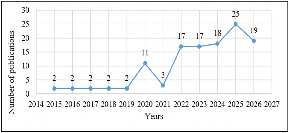
According to the systematic analysis during the study period, there has been a significant increase in scientific interest in the use of ML for rainfall-induced slope stability analysis [84]. The limited research activity is suggested by theconducted during the study period, there has been a significant increase in scientific interest in the use of ML for rainfall-induced slope-stability publication trend, as the number of publications from 2015 to 2019 was 2 per year, or 1.67% per year. The number of publications grew significantly in 2020, to 11 (9.17%), and then dropped in 2021 to 3 (2.50%). Thereafter, the field experienced strong growth, increasing to 17 publications (14.17%) in both 2022 and 2023, and to 18 (15%) in 2024. 2025 had the highest publication count with 25 (20.83%). In 2026, the number of publications was 19 (15.83%), still quite high compared with the early years [85]. The overall trend shows a clear rise in interest in research in recent years, especially since 2022. Nevertheless, the number of publications has risen significantly after 2019, a trend attributed to the rapid growth of remote sensing technologies, cloud computing, and ML methods [86]. The distribution of published papers from 2020 to 2025 accounts for more than half of the studies, suggesting that the application of data-driven methods in the analysis of slope stability has become increasingly relevant recently, as shown in Figure 3. Furthermore, the co-occurrence keyword analysis developed by VOSviewer is shown in Figure 4 [87].
Figure 3. Number of publications by year from 2015 to 2026
Figure 4. Conceptual keyword network of research themes in machine learning (ML) applications for rainfall-induced slope stability analysis
Table 5 summarises some of the important features of studies utilising ML and related computational techniques for rainfall-induced landslide susceptibility, slope stability and prediction [88]. The studies vary widely in geographic setting, landslide types, rainfall characteristics, conditioning factors, geotechnical parameters, datasets, and modelling methods. Timing-related parameters (rainfall intensity, duration, cumulative rainfall, and antecedent rainfall) are often identified as triggering variables, while slope geometry, elevation, lithology, soil type, land cover, pore-water pressure, and hydraulic properties are among the conditioning parameters. Machine learning algorithms used: RF, XGBoost, SVMs, ANNs, LightGBM, CNNs, and hybrid models. The studies also aim at different objectives, ranging from susceptibility mapping and FoS prediction to reliability analysis, spatiotemporal forecasting, and early warning [89]. Taken together, the evidence clearly shows that the performance of ML models is context-specific and highly sensitive to data quality, spatial and temporal scales, geological context, and model configuration. These differences underscore the importance of developing context-aware, physically informed, and generalisable ML frameworks for assessing rainfall-induced slope changes.
Table 5. Study characteristics, modelling approaches, validation methods, and key findings in machine learning (ML) applications to rainfall-induced landslide susceptibility assessment and slope stability analysis
|
Author/Year |
Country |
Study Area |
Landslide Type |
Rainfall Trigger |
Rainfall Variables |
Conditioning Factors |
|
Jiao et al. [90] |
China |
Rainfall-induced landslide-prone region; physics ML framework |
Rainfall-induced landslides |
Extreme rainfall |
Rainfall intensity/duration and rainfall-induced hydraulic response |
Topography, hydrology and spatial terrain characteristics |
|
Świtała et al. [91] |
Europe/Austria–Italy research context |
Numerical root-reinforced slope |
Rainfall-induced slope failure |
Rainfall infiltration |
Rainfall intensity/duration; transient rainfall |
Vegetation/root reinforcement and slope conditions |
|
Badola et al. [92] |
India |
Complex topo-climatic Himalayan terrain |
Landslides |
Monsoon/rainfall |
Rainfall and climatic variables |
Elevation, slope, aspect, topography, lithology, land cover. |
|
Li et al. [93] |
China |
Regional rainfall-prone slopes |
Rainfall-induced slope instability |
Heavy rainfall |
Rainfall intensity/duration |
Slope geometry and 3-D geometric features |
|
Huang et al. [94] |
China |
Xunwu County, Jiangxi Province |
Rainfall-induced landslides |
Continuous/heavy rainfall |
Effective rainfall, rainfall intensity-duration, and antecedent rainfall |
Topography, geology, hydrology, and land cover |
|
Hoang and Pham [95] |
Multinational |
Multiple slope-stability datasets |
Slope instability |
Not specifically rainfall-driven |
Not specifically rainfall-based |
Slope geometry and material characteristics |
|
Li et al. [96] |
China |
Heavy-rainfall slope-stability cases |
Rainfall-induced slope instability |
Heavy rainfall |
Rainfall intensity/ duration and infiltration-related parameters |
Slope geometry and hydraulic conditions |
|
Wang et al. [97] |
China |
Three representative slope types in Guizhou |
Rainfall-induced instability |
Sudden/heavy rainfall |
Rainfall intensity/duration and cumulative rainfall |
Slope geometry and slope type |
|
Mihu et al. [98] |
India |
Dibang Valley, Northeast India |
Rainfall/precipitation-induced landslides |
Monsoonal rainfall |
Rainfall/precipitation |
Elevation, lithology, lineament density, rainfall, terrain and environmental variables |
|
Yu et al. [99] |
China |
Meizhou, Guangdong Province |
Rainfall-triggered landslides |
June 2024 extreme rainfall |
Rainfall, storm conditions |
Altitude, slope, aspect, curvature, land use, NDVI, roughness, landform, distance to river/road |
|
Huang [100] |
Taiwan |
Zhuoshui River Basin, Taiwan |
Rainfall-induced landslides |
Heavy/prolonged rainfall |
Hourly rainfall, 6-h cumulative rainfall, rainfall duration |
Unstable-area evolution, watershed morphology, groundwater. |
|
Kou et al. [101] |
Global |
Global |
Global landslides |
Seasonal rainfall/climatic variability |
Seasonal precipitation and hydro-ecological variables |
17 topographic, geological, climatic, ecological and anthropogenic variables |
|
Zhou et al. [102] |
China |
High rock slope case study |
Rainfall-induced rock-slope instability |
Rainfall infiltration |
Rainfall intensity/duration and infiltration |
Slope geometry, groundwater/hydrological conditions |
|
Yusof et al. [103] |
Malaysia |
Teluk Bahang, Penang |
Shallow slope instability |
Antecedent/prolonged rainfall |
Multi-day antecedent rainfall, including 3-, 5-, 7-, 14- and 30-day periods |
Rainfall duration and antecedent moisture |
|
Abdo and Richi [104] |
Syria |
Mountainous eastern Mediterranean region |
Landslides |
Rainfall |
Rainfall and environmental/climatic predictors |
Slope, elevation, aspect, curvature, SPI, TWI |
|
Liu et al. [105] |
China |
Dingnan County, Jiangxi Province |
Colluvial landslides |
Rainfall/hydrological conditions |
Hydrological and rainfall-related environmental variables |
18 environmental factors, including terrain, hydrology, geology and surface-cover factors |
|
Debnath and Dhanekula [106] |
United States of American |
Landslide-monitoring case framework |
Landslide monitoring |
Rainfall is considered a hazard context |
Multi-temporal change indicators |
SAR/LiDAR/Sentinel-2-derived terrain and surface-change indicators |
Table 5. (continued). Study characteristics, modelling approaches, validation methods, and key findings in machine learning (ML) applications to rainfall-induced landslide susceptibility assessment and slope stability analysis
|
Geotechnical Factors |
ML Algorithm |
Model Type |
Validation |
Best Performance |
Key Finding |
|
Soil/rock strength and hydraulic parameters |
ML integrated with a physics-based model |
Physics-informed/hybrid susceptibility mapping |
Model comparison/validation against observed landslides |
A hybrid framework improves spatiotemporal prediction |
Demonstrates that combining physics-based slope-stability modelling with ML can improve prediction while retaining physical interpretability. |
|
Soil constitutive parameters, root strength, hydraulic properties, shear strength |
Extreme Gradient Boosting (XGBoost) and surrogate ML models |
ML surrogate + probabilistic reliability model |
Comparison with hydro-mechanical/reliability calculations |
R² ≥ 0.975 for XGBoost |
ML efficiently approximated the nonlinear relationships among soil/root parameters, rainfall, and slope displacement, enabling large-scale probability-of-failure estimation. |
|
Geological/lithological conditions |
XGBoost, RF, ANN |
Regional susceptibility classification |
ROC/AUC and comparative model assessment |
XGBoost/RF/ANN comparison |
ML models effectively captured complex topo-climatic controls on Himalayan landslide susceptibility. |
|
Factor of safety and slope-stability parameters |
SVR, XGBoost, RF, RFE-RF |
ML prediction of 3-D FoS |
Comparative model assessment |
Optimised RFE-RF among tested approaches |
ML can reproduce complex 3-D slope-stability responses at substantially lower computational cost than repeated numerical simulations. |
|
Geological/hydrological slope characteristics |
LR, SVM, RF |
Susceptibility + rainfall-threshold early warning |
Model comparison + threshold validation |
The effective rainfall intensity-duration threshold performed best |
Coupling spatial ML susceptibility with critical rainfall thresholds improves regional rainfall-induced hazard warning. |
|
Cohesion, friction angle, unit weight and other geotechnical parameters |
Hybrid AI/metaheuristic + ML |
Slope-stability prediction |
Prediction-error comparison |
Hybrid AI demonstrated strong predictive capability |
Demonstrates the value of hybrid AI for nonlinear slope-stability assessment, although it is not a rainfall-specific study. |
|
Soil strength, hydraulic properties and FoS |
GWO-SVR |
Hybrid ML regression |
Comparative ML validation |
GWO-SVR showed improved stability prediction |
Hybrid optimisation improves ML prediction of slope stability under heavy rainfall. |
|
Mechanical parameters, hydraulic parameters and soil/rock properties |
Eight ML algorithms, including XGBoost and ANN |
ML classification/regression of slope instability |
AUC and case-study prediction error |
XGBoost, average AUC = 0.975 |
XGBoost achieved the best overall performance; reduced-input models were also tested on three real slope cases. |
|
Soil/geological conditions |
XGBoost, LightGBM |
Explainable susceptibility classification |
ROC/AUC + SHAP |
AUC ≈ 0.96 for both models |
Rainfall, slope/elevation, lithology and lineament density were important controls; models identified high-to-very-high susceptibility zones. |
|
Soil type, particularly clay-rich red soils |
Seven ML classifiers, GBDT and SVM, highlighted |
Spatiotemporal susceptibility classification |
AUC and spatial failure capture |
AUC = 0.85; GBDT captured 69% of new failures in 18% of the landscape |
Soil type—especially clay-rich red soils—was identified as the dominant control during extreme rainfall; the importance of factors changed over time. |
|
Soil depth, hydraulic conductivity, friction angle, pore pressure, FoS |
CNN + DBSCAN + LSTM |
Physics-informed spatiotemporal forecasting |
LOSOCV across 11 sub-basins |
Hit rate 0.82 ± 0.04, F1 0.80 ± 0.05; spatial CSI 0.81, MCC 0.78 |
Integrating physical FS maps with CNN-based spatial extraction, DBSCAN-based instability classification, and LSTM-based. |
|
Soil/geological factors |
Seven ML models; CNN and GBDT among the best |
Seasonal global susceptibility mapping |
Seven-model cross-validation |
CNN/GBDT captured >75% of events while classifying <10% of land as very high risk |
Seasonal retraining revealed strong geographic differences in dominant controls; rainfall dominated in Asia, clay soils in North America and road proximity in South America. |
|
Rock-mass strength, permeability and pore-water pressure |
Numerical/ field case data |
Physics-based numerical slope-stability model |
Numerical/field comparison |
FoS-based assessment |
Demonstrated that rainfall infiltration alters pore-water pressure and effective stress and consequently changes slope FoS. |
|
Soil hydraulic/mechanical properties, pore pressure and FoS |
Numerical data analysis |
Transient seepage + limit equilibrium |
Numerical stability assessment |
FoS response to antecedent rainfall |
Longer antecedent rainfall increases soil wetness/pore pressure and decreases slope stability; useful as a physical benchmark for ML studies. |
|
Soil depth and lithology |
SVM, RF, XGBoost |
Regional susceptibility classification |
ROC/AUC, precision, recall, F1, MCC |
RF AUC = 0.96; XGBoost = 0.94; SVM = 0.90 |
RF provided the strongest susceptibility prediction among the tested models. |
|
Lithology and hydrological/geotechnical characteristics |
RF, SVM |
Slope-unit susceptibility classification |
ROC/AUC and uncertainty analysis |
RF AUC = 0.896; SVM AUC = 0.871 |
RF outperformed SVM and demonstrated lower uncertainty in regional landslide susceptibility prediction. |
|
Limited direct geotechnical variables |
AI-based change detection |
Monitoring/early-warning model |
Change-detection/early-warning assessment |
AI full regression model R² = 0.62 |
Demonstrates the potential of multi-source remote sensing and AI for landslide monitoring and early-warning applications. |
Thematic evolution analysis revealed a clear evolution of research over time. Previous research was primarily focused on traditional susceptibility mapping using statistical and simple machine-learning classifiers [107]. Later, research moved towards an ensemble learning approach, a feature selection method, and a GIS-based model. Recent publications have focused more on high-level deep learning architectures, XAI, combinations of numerical and machine-learning models, and real-time monitoring systems [108]. Based on the keyword trend analysis, emerging topics include Graph Neural Networks (GNNs), Transformer-based architectures, SHAP-based interpretability methods, digital twins, IoT-enabled monitoring systems, and physics-informed ML [109]. These new themes indicate an increasing focus on developing intelligent, explainable, and deployable prediction systems to enable proactive landslide risk management.
Finally, the descriptive results confirm the rapid development of ML applications for analysing rainfall-induced slope stability over the past decade. The study found that trends in publications, collaboration networks, and thematic development pointed towards future research directions in explainable, physics-informed, and autonomous prediction systems. These systems will help manage resilient infrastructure and disaster risk reduction under increasingly complex environmental conditions [110]. However, results may vary based on data quality, feature quality, and data validation processes, making it important to ensure the models are well evaluated.
4.2 Discussion based on research questions
The systematic review revealed that ML models developed to analyse rainfall-induced slope stability have made significant advances. ML has been used in the studies reviewed as a tool to facilitate analytical processes of landslide susceptibility assessment and early warning, rather than being a standalone method.
RQ1: What are the most used ML techniques in rainfall-induced slope stability analysis?
High-resolution geospatial data has also made it easier to adopt deep learning architectures like Convolutional Neural Networks (CNNs), Long Short-Term Memory (LSTM) networks, and GNNs. The application of deep learning algorithms to large-scale landslide susceptibility datasets yielded classification accuracy > 90% and AUC > 0.90 in several studies [111]. Although these results are encouraging, ensemble learning approaches are the most prevalent in the literature due to their relatively lower computational complexity and interpretability compared with deep neural network approaches. Therefore, RF and XGBoost could be considered state-of-the-art algorithms for rainfall-induced landslide prediction and susceptibility mapping.
The literature reviewed shows that the most commonly used ML algorithms in rainfall-induced slope stability studies include ANNs, SVMs, RFs, and XGBoost. Early studies focused on ANN and SVM models due to their ability to handle complex geotechnical data and their strong potential for nonlinear prediction. However, in recent publications, ensemble learning algorithms such as RF and XGBoost have been found to be popular due to their performance, resistance to overfitting, and variable ranking.
RQ2: What are the data sources, input parameters, and performance metrics that are commonly used?
The review shows that the quality and diversity of input data significantly impact the success of ML applications. The most common category of predictors used is rainfall information such as rainfall intensity, cumulative rainfall, antecedent rainfall, rainfall duration, and maximum hourly precipitation [112]. However, variables related to rainfall are seldom used independently. Most studies integrate rainfall data with topographic, geological, hydrological, environmental, and geotechnical information to enhance prediction accuracy.
These geospatial variables are typically used: slope angle, elevation, aspect, curvature, lithology, land use characteristics (LUC), normalised difference vegetation index (NDVI), topographic wetness index (TWI), and drainage density. Improvements in remote-sensing technology have also increased the amount of high-resolution data acquired via LiDAR, SAR, UAV, and satellite imagery. In model evaluation, the most commonly reported metric is the AUC, a threshold-independent measure [113]. Other frequently used measures are Accuracy, Precision, Recall, F1 score, RMSE, and Mean Absolute Error (MAE).
RQ3: How effective are ML approaches compared with conventional methods?
A key finding across all reviewed studies is that ML models achieved higher predictive accuracy than traditional geotechnical methods. The traditional methods, such as the LEM, FEM, and FDM, remain useful for gaining insight into failure mechanisms and computing factors of safety. Their use, however, is frequently accompanied by extensive characterisation of their parameters, high computational power, and assumptions about soil behaviour and boundary conditions [114].
ML methods offer benefits, especially when large, diverse datasets are available. ML models consistently outperformed traditional statistical and deterministic models in terms of classification accuracy and AUC. Nevertheless, conventional numerical models continue to play an important role because they provide physically interpretable results. In recent years, research has increasingly supported the hybrid approach, i.e., using ML alongside FEM, FDM, or LEM to leverage the strengths of data-driven and physics-based approaches [115, 116].
RQ4: What are the major research gaps and future opportunities in this field?
Although there have been many advances, there are still gaps in research. The first challenge concerns data availability and quality. Many studies use region-specific datasets that are small, have varying data-collection processes, and exhibit class imbalance. These restrictions can reduce the model's generalizability and make it difficult to transfer to other geographic locations. In addition, many ML models are "black-box" models that do not allow engineers or decision-makers to understand the results of their predictions. This has led to interest in developing XAI techniques such as SHAP and LIME, which offer greater insight into variable importance and model behaviour [117].
Another emerging challenge is around the incorporation of real-time monitoring technologies and predictive modelling. The rapidly increasing volume of environmental data collected by the Internet of Things (IoT), satellites, and remote sensing platforms has created unprecedented data volumes, yet the application of these resources in operational early warning systems (EWS) remains relatively limited. Similarly, digital twin technologies in geotechnical engineering have many applications in continuous monitoring, predictive simulation, and risk management, but remain in the early stages [118, 119]. Moving forward, explainable, physics-informed, and autonomous prediction frameworks that integrate ML, geotechnical modelling, IoT monitoring, and digital twin technologies should be developed. These are expected to be key enablers for increasing infrastructure resilience and reducing the risk of landslides due to climate variability and change.
Therefore, while the use of ML in rainfall-induced landslides and slope-instability assessment has gained momentum, there is a lack of literature that connects the various available machine-learning methods on different scales [119, 120]. Notably, there are significant challenges in physics–ML integration, cross-site generalisation, uncertainty quantification, model interpretability, and translating predictive output into operational risk management decisions. Table 6 shows the five gaps identified from the study for future research.
Table 6. The identified research gaps from the systematic review study
|
Research Gap |
What is Missing in Existing Studies |
Why it Matters |
|
Lack of integration across ML application domains |
Existing studies often examine FoS prediction, susceptibility mapping, displacement prediction, or early warning separately. Few studies systematically connect these four domains. |
A unified framework could clarify how ML supports the progression from slope stability assessment → spatial susceptibility → deformation monitoring → early warning. |
|
Limited integration of physical geotechnical knowledge with ML |
Many ML models rely heavily on statistical relationships and may not explicitly represent rainfall infiltration, pore-water pressure, effective stress, and shear-strength reduction. |
Physics–ML integration could improve model reliability, interpretability, and generalisation under different rainfall and geological conditions. |
|
Poor transferability and generalisation across sites |
Models are frequently developed and validated using data from a particular slope, region, geological formation, or climatic environment. |
A model that performs well at one site may not necessarily work elsewhere because rainfall patterns, soil properties, terrain, geology, and land use differ. |
|
Insufficient treatment of uncertainty and explainability |
High predictive accuracy is often emphasised, while uncertainty in rainfall measurements, soil parameters, monitoring data, labels, and model predictions receives less attention. |
Slope-failure prediction is safety-critical; engineers need to understand why a model makes a prediction and how confident they can be in that prediction. |
|
Weak connection between ML prediction and operational early-warning decisions |
Many studies demonstrate prediction accuracy but do not sufficiently address how predictions can be converted into actionable warning thresholds or response levels. |
Bridging ML outputs with monitoring systems, rainfall thresholds, IoT, GIS, and emergency decision-making would improve practical disaster-risk reduction. |
The purpose of this systematic literature review was to explore the application of ML techniques to the study of rain-induced slope stability, with a focus on landslide susceptibility assessment, predictive modelling, data integration, and intelligent monitoring systems. The PRISMA framework was followed in a structured review process, and 120 relevant studies were analysed to draw conclusions on general research trends, the most frequently used methodology, the main data sources, metrics used to monitor and assess technology performance, and technological developments arising from the research. The results showed that rainfall-induced slope instability is a major geotechnical and environmental issue worldwide, and that more efficient and reliable predictive models should be developed. As the amount of geospatial data, computing power, and remote sensing tools continues to increase, ML approaches offer a potential way to assess hazards and mitigate risk.
The study revealed that the ML techniques most widely applied in rainfall-induced slope stability studies are Artificial Neural Networks, SVMs, RF, and XGBoost. Among these, ensemble learning methods such as RF and XGBoost performed well at predicting experimental outcomes, as they capture nonlinear relationships and are resistant to overfitting. In addition, developments in deep learning have enabled the creation of more complex predictive models that can detect intricate spatial and temporal patterns in massive geospatial data. Prediction accuracy and operational use have been further enhanced by recent developments in GIS, remote sensing, and numerical modelling.
The descriptive and thematic analysis revealed that the research field is growing rapidly, with steadily increasing publications, international activities, and ongoing methodological development. New research areas are: explainable AI, hybrid ML–numerical simulation techniques, IoT-based monitoring techniques, digital twin techniques and physics-informed ML techniques. However, there are still a number of challenges to address, including data limitations, limited transferability of geographical models, limited interpretability of complex models, and the lack of complete real-time prediction systems. Solving these issues will be fundamental in making research advances a reality in engineering solutions.
Based on the overall results of this systematic review, new efforts should be made to develop large, high-quality public datasets for rainfall-induced slope-stability analysis. The lack of uniformity in geotechnical, hydrological, and landslide inventories was one of the main limitations identified in the literature reviewed, which restricts the generalisation and transferability of models. Hence, it is suggested that integrated databases of rainfall, soil, geology, and remote sensing data, along with recorded landslide events, should be prioritised across different climatic and geographical regions as part of the research agenda. This would result in more robust and reproducible ML models and enable sensible comparative work.
Additionally, a shift from traditional ML techniques (ANN, SVM, and RF) to more advanced and interpretable methods is needed. Deep learning architectures, transformer-based models, physics-informed ML, and XAI methods are potential approaches for future study. The use of hybrid intelligent frameworks that combine ML methods and GIS, remote sensing, IoT monitoring systems, and numerical modelling (e.g., FEM, LEM) is also recommended. These systems can be coupled with real-time monitoring and dynamic prediction, which can be helpful for EWS and disaster risk reduction strategies. Further research could also involve using digital twins to monitor slopes, enabling continuous tracking of slope conditions through real-time sensor data and predictive models.
Finally, greater consideration needs to be given to the effects of climate change on rainfall-induced slope instability. With rising frequency and intensity of extreme weather events, traditional landslide-triggering mechanisms and rainfall thresholds will change. In this respect, ML should be combined with climate projections, uncertainty quantification, and probabilistic risk assessment in the future.
While this systematic literature review offers a study of the applications of ML in modelling rainfall-induced slope stability and landslide susceptibility, there are some limitations to be noted, such as:
1. The review was limited mainly to English-language publications, which could have led to language-selection bias and to some studies not being published in English.
2. Secondly, the use of Google Scholar can give more general coverage of supplementary literature, but it can be less reproducible because the ranking, indexing, and retrieval results can change over time and may not be as transparent as in structured bibliographic databases.
3. Thirdly, there was significant methodological variation between the included studies, ranging from small datasets to large ones, limited geographic sampling, different prediction tasks, feature selection, imbalanced classes, different validation procedures, and poor reporting.
4. Lastly, the review was completed in the year 2026, so some recently published studies may not have been among the included studies at the time of the search. Thus, the review cannot include all publications released towards the end of the 2026 indexing cycle. The limitations mentioned should be considered when interpreting the completeness and generalizability of the evidence synthesised in this review.
[1] Alcántara-Ayala, I. (2025). Landslides in a changing world. Landslides, 22(9): 2851-2865. https://doi.org/10.1007/s10346-024-02451-1
[2] Amarasinghe, M.P., Kulathilaka, S.A.S., Robert, D.J., Zhou, A., Jayathissa, H.A.G. (2023). Risk assessment and management of rainfall-induced landslides in tropical regions: A review. Natural Hazards, 120(3): 2179-2231. https://doi.org/10.1007/s11069-023-06277-3
[3] Zhang, Q., Shen, D. (2024). Rainfall-induced landslides: Influencing, modelling and hazard assessment. Water, 16(23): 3384. https://doi.org/10.3390/w16233384
[4] Ebrahim, K.M.P., Gomaa, S.M.M.H., Zayed, T., Alfalah, G. (2024). Rainfall-induced landslide prediction models, part II: Deterministic physical and phenomenological models. Bulletin of Engineering Geology and the Environment, 83: 85. https://doi.org/10.1007/s10064-024-03563-7
[5] NASA Earth Observatory. (2026). A global view of landslide susceptibility. NASA Science. https://science.nasa.gov/earth/earth-observatory/a-global-view-of-landslide-susceptibility-89937/.
[6] Paudyal, P., Dahal, P., Bhandari, P., Dahal, B.K. (2023). Sustainable rural infrastructure: Guidelines for roadside slope excavation. Geoenvironmental Disasters, 10: 11. https://doi.org/10.1186/s40677-023-00240-x
[7] Xu, H., He, X., Shan, F., Niu, G., Sheng, D. (2023). Machine learning in the stochastic analysis of slope stability: A state-of-the-art review. Modelling, 4(4): 426-453. https://doi.org/10.3390/modelling4040025
[8] Zhang, W., Gu, X., Hong, L., Han, L., Wang, L. (2023). Comprehensive review of machine learning in geotechnical reliability analysis: Algorithms, applications and further challenges. Applied Soft Computing, 136: 110066. https://doi.org/10.1016/j.asoc.2023.110066
[9] Rababa, F., Ngezahayo, E., Jefferson, I. (2026). Laboratory-based physical modeling of rainfall-induced landslides: A systematic review. Modeling Earth Systems and Environment, 12: 118. https://doi.org/10.1007/s40808-026-02777-w
[10] Vung, D.V., Tran, T.V., Duc Ha, N., Huy Duong, N. (2023). Advancements, challenges, and future directions in rainfall-induced landslide prediction: A comprehensive review. Journal of Engineering and Technological Sciences, 55(4): 466-477. https://doi.org/10.5614/j.eng.technol.sci.2023.55.4.9
[11] Kudaibergenov, M., Nurakynov, S., Iskakov, B., et al. (2024). Application of artificial intelligence in landslide susceptibility assessment: Review of recent progress. Remote Sensing, 17(1): 34. https://doi.org/10.3390/rs17010034
[12] Kang, J., Wan, B., Gao, Z., Zhou, S., Chen, H., Shen, H. (2024). Research on machine learning forecasting and early warning model for rainfall-induced landslides in Yunnan province. Scientific Reports, 14(1): 14049. https://doi.org/10.1038/s41598-024-64679-0
[13] Antzoulatos, G., Kouloglou, I.O., Bakratsas, M., et al. (2022). Flood hazard and risk mapping by applying an explainable machine learning framework using satellite imagery and GIS data. Sustainability, 14(6): 3251. https://doi.org/10.3390/su14063251
[14] Pugliese Viloria, A.de J., Folini, A., Carrion, D., Brovelli, M.A. (2024). Hazard susceptibility mapping with machine and deep learning: A literature review. Remote Sensing, 16(18): 3374. https://doi.org/10.3390/rs16183374
[15] Cui, H.Z., Tong, B., Wang, T., Dou, J., Ji, J. (2025). A hybrid data-driven approach for rainfall-induced landslide susceptibility mapping: Physically-based probabilistic model with convolutional neural network. Journal of Rock Mechanics and Geotechnical Engineering, 17(8): 4933-4951. https://doi.org/10.1016/j.jrmge.2024.08.005
[16] Yaghoubi, E., Yaghoubi, E., Khamees, A., Vakili, A.H. (2024). A systematic review and meta-analysis of artificial neural network, machine learning, deep learning, and ensemble learning approaches in field of geotechnical engineering. Neural Computing and Applications, 36(21): 12655-12699. https://doi.org/10.1007/s00521-024-09893-7
[17] Trinidad, M., Momayez, M. (2025). Machine learning in slope stability: A review with implications for landslide hazard assessment. GeoHazards, 6(4): 67. https://doi.org/10.3390/geohazards6040067
[18] Robinson, J.D., Vahedifard, F., AghaKouchak, A. (2017). Rainfall-triggered slope instabilities under a changing climate: Comparative study using historical and projected precipitation extremes. Canadian Geotechnical Journal, 54(1): 117-127. https://doi.org/10.1139/cgj-2015-0602
[19] Zhu, D., Song, K., Mu, J., et al. (2020). Effect of climate change induced extreme precipitation on landslide activity in the Three Gorges Reservoir, China. Bulletin of Engineering Geology and the Environment, 80(2): 781-794. https://doi.org/10.1007/s10064-020-01948-y
[20] Gael, C.N., Luc Leroy, M.N., Christian, F.B. (2025). Research on slope stability assessment methods: A comparative analysis of limit equilibrium, finite element, and analytical approaches for road embankment stabilization. AI in Civil Engineering, 4(1). https://doi.org/10.1007/s43503-024-00046-2
[21] Arif, A., Zhang, C., Sajib, M.H., et al. (2025). Rock slope stability prediction: A review of machine learning techniques. Geotechnical and Geological Engineering, 43(3): 124. https://doi.org/10.1007/s10706-025-03091-5
[22] Haddaway, N.R., Page, M.J., Pritchard, C.C., McGuinness, L.A. (2022). PRISMA2020: An R package and Shiny app for producing PRISMA 2020-compliant flow diagrams, with interactivity for optimised digital transparency and open synthesis. Campbell Systematic Reviews, 18(2): cl2-1230. https://doi.org/10.1002/cl2.1230
[23] Page, M.J., McKenzie, J.E., Bossuyt, P.M., et al. (2021). The PRISMA 2020 statement: An updated guideline for reporting systematic reviews. Systematic Reviews, 10: 89. https://doi.org/10.1186/s13643-021-01626-4
[24] Bagheri, M. (2025). Data-driven prediction of rainfall-triggered slope movements using flume tests and interpretable machine learning models. Transportation Infrastructure Geotechnology, 12: 305. https://doi.org/10.1007/s40515-025-00737-y
[25] Roccati, A., Paliaga, G., Luino, F., Faccini, F., Turconi, L. (2020). Rainfall threshold for shallow landslides initiation and analysis of long-term rainfall trends in a Mediterranean area. Atmosphere, 11(12): 1367. https://doi.org/10.3390/atmos11121367
[26] Mondini, A.C., Guzzetti, F., Melillo, M. (2023). Deep learning forecast of rainfall-induced shallow landslides. Nature Communications, 14: 2466. https://doi.org/10.1038/s41467-023-38135-y
[27] Abraham, M.T., Satyam, N., Kushal, S., Rosi, A., Pradhan, B., Segoni, S. (2020). Rainfall threshold estimation and landslide forecasting for Kalimpong, India using SIGMA model. Water, 12(4): 1195. https://doi.org/10.3390/w12041195
[28] Nair, A.A., Amrutha, A.S., Pradeep, G.S., Vijith, H. (2026). Landslide susceptibility and local antecedent rainfall thresholds in the Highland Western Ghats Kerala India. Discover Hazards, 2: 51. https://doi.org/10.1007/s44475-026-00056-x
[29] Menon, V., Kolathayar, S. (2025). Empirical and machine learning-based approaches to identify rainfall thresholds for landslide prediction: A case study of Kerala, India. Discover Applied Sciences, 7: 203. https://doi.org/10.1007/s42452-025-06636-8
[30] Ma, G., Zhou, A., Bui, H.H. (2026). Smoothed particle hydrodynamics (SPH) modelling for rainfall-induced unsaturated slope failure considering void ratio dependence and variability. Computers and Geotechnics, 189: 107629. https://doi.org/10.1016/j.compgeo.2025.107629
[31] Zhou, F., Wu, H., Qiang, Y., et al. (2025). Investigating the coupling effects of rainfall intensity and slope inclination on soil-rock mixture slope stability and failure modes. PLoS ONE, 20(2): e0314752. https://doi.org/10.1371/journal.pone.0314752
[32] Naidu, S., Sajinkumar, K.S., Oommen, T., Anuja, V.J., Samuel, R.A., Muraleedharan, C. (2018). Early warning system for shallow landslides using rainfall threshold and slope stability analysis. Geoscience Frontiers, 9(6): 1871-1882. https://doi.org/10.1016/j.gsf.2017.10.008
[33] Ebrahim, K., Gomaa, S.M.M.H., Zayed, T., Alfalah, G. (2025). Rainfall-induced landslide prediction models, part I: Empirical–statistical and physically based causative thresholds. Water, 17(22): 3273. https://doi.org/10.3390/w17223273
[34] Yang, F., Hasan, M. (2026). Comprehensive risk mapping and management of rainfall-induced slope failures in urbanizing subtropical regions. Scientific Reports, 16: 17951. https://doi.org/10.1038/s41598-026-49114-w
[35] Badapalli, P.K., Nakkala, A.B., Kottala, R.B., et al. (2025). Landslide susceptibility level mapping in Kozhikode, Kerala, using machine learning-based random forest, remote sensing, and GIS techniques. Land, 14(7): 1453. https://doi.org/10.3390/land14071453
[36] Haddad, B.A.E., Youssef, A.M., Pourghasemi, H.R. (2025). From ancient to recent floods: Advances in flood susceptibility modeling and vulnerability, Makkah, Saudi Arabia. Natural Hazards, 122: 12. https://doi.org/10.1007/s11069-025-07871-3
[37] Amarasinghe, M.P., Robert, D., Kulathilaka, S.A.S., Zhou, A., Jayathissa, H.A.G. (2026). Prediction of rainfall-induced shallow landslide runout integrating hydro-mechanical slope stability analysis. Georisk: Assessment and Management of Risk for Engineered Systems and Geohazards, 1-21. https://doi.org/10.1080/17499518.2025.2607420
[38] Soltaninejad, S., Abdollahi, M.S., BP, N., Marandi, S.M., Abdollahi, M., Abdollahi, S. (2025). Toward sustainable infrastructure: Advanced hazard prediction and geotechnical risk management in the Jiroft Dam project, Iran. Sustainability, 17(4): 1465. https://doi.org/10.3390/su17041465
[39] Abdelkader, M.M., Csámer, Á. (2025). Comparative assessment of machine learning models for landslide susceptibility mapping: A focus on validation and accuracy. Natural Hazards, 121(9): 10299-10321. https://doi.org/10.1007/s11069-025-07197-0
[40] Su, Q., Zhang, J., Zhao, S., Wang, L., Liu, J., Guo, J. (2017). Comparative assessment of three nonlinear approaches for landslide susceptibility mapping in a coal mine area. ISPRS International Journal of Geo-Information, 6(7): 228. https://doi.org/10.3390/ijgi6070228
[41] Ajin, R.S., Segoni, S., Fanti, R. (2024). Optimization of SVR and CatBoost models using metaheuristic algorithms to assess landslide susceptibility. Scientific Reports, 14: 24851. https://doi.org/10.1038/s41598-024-72663-x
[42] Sun, D., Wen, H., Wang, D., Xu, J. (2020). A random forest model of landslide susceptibility mapping based on hyperparameter optimization using Bayes algorithm. Geomorphology, 362: 107201. https://doi.org/10.1016/j.geomorph.2020.107201
[43] Ali, S.A., Parvin, F., Vojteková, J., et al. (2021). GIS-based landslide susceptibility modeling: A comparison between fuzzy multi-criteria and machine learning algorithms. Geoscience Frontiers, 12(2): 857-876. https://doi.org/10.1016/j.gsf.2020.09.004
[44] Zheng, Z., Zhang, K., Wang, N., Zhu, M., He, Z. (2024). Machine learning–based systems for early warning of rainfall-induced landslide. Natural Hazards Review, 25: 04024027. https://doi.org/10.1061/nhrefo.nheng-1993
[45] Li, D., Bai, Y., Xiao, Y., Zhang, Y., Cheng, X., Xie, Y. (2025). Applications of machine learning algorithms and neural networks in slope stability analysis: A review and outlook. Arabian Journal of Geosciences, 18: 215. https://doi.org/10.1007/s12517-025-12375-2
[46] Afandi, G.E., Moustafa, A., Ibrahim, S., Irfan, M. (2025). An in-depth analysis of approaches for forecasting extreme rainfall events leveraging artificial intelligence, machine learning, and deep learning techniques. Earth Systems and Environment, 10(4): 5073-5104. https://doi.org/10.1007/s41748-025-00813-w
[47] Huang, F., Cao, Z., Guo, J., Jiang, S.-H., Li, S., Guo, Z. (2020). Comparisons of heuristic, general statistical and machine learning models for landslide susceptibility prediction and mapping. CATENA, 191: 104580. https://doi.org/10.1016/j.catena.2020.104580
[48] Chen, X., Chen, W. (2021). GIS-based landslide susceptibility assessment using optimized hybrid machine learning methods. CATENA, 196: 104833. https://doi.org/10.1016/j.catena.2020.104833
[49] Peiro, Y., Volpe, E., Ciabatta, L., Cattoni, E. (2024). High resolution precipitation and soil moisture data integration for landslide susceptibility mapping. Geosciences, 14(12): 330. https://doi.org/10.3390/geosciences14120330
[50] Monsieurs, E., Dewitte, O., Demoulin, A. (2019). A susceptibility-based rainfall threshold approach for landslide occurrence. Natural Hazards and Earth System Sciences, 19(4): 775-789. https://doi.org/10.5194/nhess-19-775-2019
[51] Merghadi, A., Yunus, A.P., Dou, J., et al. (2020). Machine learning methods for landslide susceptibility studies: A comparative overview of algorithm performance. Earth-Science Reviews, 207: 103225. https://doi.org/10.1016/j.earscirev.2020.103225
[52] Arabameri, A., Saha, S., Roy, J., Chen, W., Blaschke, T., Tien Bui, D. (2020). Landslide susceptibility evaluation and management using different machine learning methods in the Gallicash River watershed, Iran. Remote Sensing, 12(3): 475. https://doi.org/10.3390/rs12030475
[53] Chen, J., Chen, Y., Zheng, Z., Wen, Z., Chen, Y., Huang, J. (2026). EaSFE: Scalable and efficient feature engineering for boosting machine learning performance. ACM Transactions on Knowledge Discovery from Data, 20(5): 1-19. https://doi.org/10.1145/3816023
[54] Chen, C., Shen, Z., Weng, Y., et al. (2023). Modeling landslide susceptibility in forest-covered areas in Lin’an, China, using logistical regression, a decision tree, and random forests. Remote Sensing, 15(18): 4378. https://doi.org/10.3390/rs15184378
[55] Kumar Bhagat, N., Mishra, A.K., Singh, R.K., Sawmliana, C., Singh, P.K. (2022). Application of logistic regression, CART and random forest techniques in prediction of blast-induced slope failure during reconstruction of railway rock-cut slopes. Engineering Failure Analysis, 137: 106230. https://doi.org/10.1016/j.engfailanal.2022.106230
[56] Pham, K., Kim, D., Park, S., Choi, H. (2021). Ensemble learning-based classification models for slope stability analysis. CATENA, 196: 104886. https://doi.org/10.1016/j.catena.2020.104886
[57] Li, B., Liu, K., Wang, M., et al. (2022). Global dynamic rainfall-induced landslide susceptibility mapping using machine learning. Remote Sensing, 14(22): 5795. https://doi.org/10.3390/rs14225795
[58] Zerouali, B., Bailek, N., Tariq, A., et al. (2024). Enhancing deep learning-based slope stability classification using a novel metaheuristic optimization algorithm for feature selection. Scientific Reports, 14: 21812. https://doi.org/10.1038/s41598-024-72588-5
[59] Mulualem, T., Mekonnen, M. (2020). Landslide susceptibility mapping using frequency ratio and weights of evidence models in the Guna mountainous chain of Simada area, Ethiopia. Geoenvironmental Disasters, 7: 20. https://doi.org/10.1186/s40677-020-00155-x
[60] Chen, W., Li, Y. (2020). GIS-based evaluation of landslide susceptibility using hybrid computational intelligence models. CATENA, 195: 104777. https://doi.org/10.1016/j.catena.2020.104777
[61] Wei, A., Yu, K., Dai, F., Gu, F., Zhang, W., Liu, Y. (2022). Application of tree-based ensemble models to landslide susceptibility mapping: A comparative study. Sustainability, 14(10): 6330. https://doi.org/10.3390/su14106330
[62] Gupta, A., Aggarwal, Y., Aggarwal, P. (2022). Deep neural network and ANN ensemble for slope stability prediction. Archives of Materials Science and Engineering, 116(1): 14-27. https://doi.org/10.5604/01.3001.0016.0975
[63] Kumar, R., Penna, I., Lal, D., et al. (2026). Multi-model geostatistical and machine learning-based framework for landslide susceptibility and risk assessment in the Upper Ravi Basin, North-Western Himalaya, India. Earth Systems and Environment. https://doi.org/10.1007/s41748-026-01229-w
[64] Mejia-Manrique, S.A., Ramos-Scharrón, C.E., Hughes, K.S., Gonzalez-Cruz, J.E., Khanbilvardi, R.M. (2025). Dynamic landslide susceptibility for extreme rainfall events using an optimized convolutional neural network approach. Natural Hazards, 121(13): 15383-15411. https://doi.org/10.1007/s11069-025-07396-9
[65] Garg, A. (2026). Seven-day landslide forecasting from PCA-derived InSAR data with a random forest classifier. Earth Systems and Environment. https://doi.org/10.1007/s41748-026-01227-y
[66] Khalili, M.A., Guerriero, L., Pouralizadeh, M., Calcaterra, D., Di Martire, D. (2023). Monitoring and prediction of landslide-related deformation based on the GCN-LSTM algorithm and SAR imagery. Natural Hazards, 119(1): 39-68. https://doi.org/10.1007/s11069-023-06121-8
[67] Kumar, C., Walton, G., Santi, P., Luza, C. (2023). An ensemble approach of feature selection and machine learning models for regional landslide susceptibility mapping in the arid mountainous terrain of southern Peru. Remote Sensing, 15(5): 1376. https://doi.org/10.3390/rs15051376
[68] Sachdeva, S., Bhatia, T., Verma, A.K. (2019). A novel voting ensemble model for spatial prediction of landslides using GIS. International Journal of Remote Sensing, 41(3): 929-952. https://doi.org/10.1080/01431161.2019.1654141
[69] Abedini, M., Ghasemian, B., Shirzadi, A., et al. (2018). A novel hybrid approach of Bayesian logistic regression and its ensembles for landslide susceptibility assessment. Geocarto International, 34(13): 1427-1457. https://doi.org/10.1080/10106049.2018.1499820
[70] Nurwatik, N., Ummah, M.H., Cahyono, A.B., Darminto, M.R., Hong, J.H. (2022). A comparison study of landslide susceptibility spatial modeling using machine learning. ISPRS International Journal of Geo-Information, 11(12): 602. https://doi.org/10.3390/ijgi11120602
[71] Huang, F., Xiong, H., Chen, S., et al. (2023). Slope stability prediction based on a long short-term memory neural network: Comparisons with convolutional neural networks, support vector machines and random forest models. International Journal of Coal Science & Technology, 10: 18. https://doi.org/10.1007/s40789-023-00579-4
[72] Li, X., Nishio, M., Sugawara, K., Iwanaga, S., Chun, P. (2023). Surrogate model development for slope stability analysis using machine learning. Sustainability, 15(14): 10793. https://doi.org/10.3390/su151410793
[73] Showkat, M., Ghani, S. (2025). Surrogate modeling for slope stability: Integrating limit equilibrium method with machine learning. Multiscale and Multidisciplinary Modeling, Experiments and Design, 8: 253. https://doi.org/10.1007/s41939-025-00853-9
[74] Ragam, P., Kushal Kumar, N., Ajith, J.E., et al. (2024). Estimation of slope stability using ensemble-based hybrid machine learning approaches. Frontiers in Materials, 11: 1330609. https://doi.org/10.3389/fmats.2024.1330609
[75] Liu, R., Yang, X., Xu, C., Wei, L., Zeng, X. (2022). Comparative study of convolutional neural network and conventional machine learning methods for landslide susceptibility mapping. Remote Sensing, 14(2): 321. https://doi.org/10.3390/rs14020321
[76] Zhang, S., Bai, L., Li, Y., Li, W., Xie, M. (2022). Comparing convolutional neural network and machine learning models in landslide susceptibility mapping: A case study in Wenchuan County. Frontiers in Environmental Science, 10: 886841. https://doi.org/10.3389/fenvs.2022.886841
[77] Yi, Y., Zhang, Z., Zhang, W., Jia, H., Zhang, J. (2020). Landslide susceptibility mapping using multiscale sampling strategy and convolutional neural network: A case study in Jiuzhaigou region. CATENA, 195: 104851. https://doi.org/10.1016/j.catena.2020.104851
[78] Li, Z., Shi, A., Li, X., Dou, J., Li, S., Chen, T., Chen, T. (2024). Deep learning-based landslide recognition incorporating deformation characteristics. Remote Sensing, 16(6): 992. https://doi.org/10.3390/rs16060992
[79] Li, R., Li, J., Zhou, Y., et al. (2026). Random forest-based landslide risk assessment for mountain roads under extreme rainfall: Implications for infrastructure resilience. Sustainability, 18(9): 4427. https://doi.org/10.3390/su18094427
[80] Cai, Y., Yuan, Y., Zhou, A. (2024). Predictive slope stability early warning model based on CatBoost. Scientific Reports, 14: 25727. https://doi.org/10.1038/s41598-024-77058-6
[81] Alqadhi, S., Mallick, J., Alkahtani, M., Ahmad, I., Alqahtani, D., Hang, H.T. (2023). Developing a hybrid deep learning model with explainable artificial intelligence (XAI) for enhanced landslide susceptibility modeling and management. Natural Hazards, 120(4): 3719-3747. https://doi.org/10.1007/s11069-023-06357-4
[82] Al-Najjar, H.A.H., Pradhan, B., Beydoun, G., Sarkar, R., Park, H.J., Alamri, A. (2023). A novel method using explainable artificial intelligence (XAI)-based Shapley Additive Explanations for spatial landslide prediction using time-series SAR dataset. Gondwana Research, 123: 107-124. https://doi.org/10.1016/j.gr.2022.08.004
[83] Zhou, X., Wen, H., Li, Z., Zhang, H., Zhang, W. (2022). An interpretable model for the susceptibility of rainfall-induced shallow landslides based on SHAP and XGBoost. Geocarto International, 37(26): 13419-13450. https://doi.org/10.1080/10106049.2022.2076928
[84] Liu, X., Wang, Y., Koo, R.C.H., Kwan, J.S.H. (2022). Development of a slope digital twin for predicting temporal variation of rainfall-induced slope instability using past slope performance records and monitoring data. Engineering Geology, 308: 106825. https://doi.org/10.1016/j.enggeo.2022.106825
[85] Xu, J., Zhang, Y. (2025). AI-powered digital twin technology for highway system slope stability risk monitoring. Geotechnics, 5(1): 19. https://doi.org/10.3390/geotechnics5010019
[86] Piciullo, L., Abraham, M.T., Drøsdal, I.N., Paulsen, E.S. (2025). An operational IoT-based slope stability forecast using a digital twin. Environmental Modelling & Software, 183: 106228. https://doi.org/10.1016/j.envsoft.2024.106228
[87] Ren, T., Gao, L., Gong, W. (2023). An ensemble of dynamic rainfall index and machine learning method for spatiotemporal landslide susceptibility modeling. Landslides, 21(2): 257-273. https://doi.org/10.1007/s10346-023-02152-1
[88] Hammouda, N.G., Kriaa, K., Alizadeh, A., et al. (2026). Physically informed machine learning for predicting non-Newtonian blood flow in Giant MCA aneurysms after endovascular treatment. International Communications in Heat and Mass Transfer, 172: 110296. https://doi.org/10.1016/j.icheatmasstransfer.2025.110296
[89] Ye, P., Yu, B., Chen, W., Liu, K., Ye, L. (2022). Rainfall-induced landslide susceptibility mapping using machine learning algorithms and comparison of their performance in hilly area of Fujian Province, China. Natural Hazards, 113(2): 965-995. https://doi.org/10.1007/s11069-022-05332-9
[90] Jiao, X., Gao, L., Fei, K., Chen, S. (2026). An enhanced framework for mapping rainfall-induced landslides by integrating physics-based numerical modelling with machine learning. Journal of Rock Mechanics and Geotechnical Engineering. https://doi.org/10.1016/j.jrmge.2026.03.028
[91] Świtała, B.M., Guardiani, C., Soranzo, E., Wu, W. (2023). Machine learning-aided reliability analysis of rainfall-induced landslide of root-reinforced slopes. Canadian Geotechnical Journal, 60(12): 1877-1894. https://doi.org/10.1139/cgj-2022-0696
[92] Badola, S., Pandey, M., Mishra, V.N., Parkash, S., Zhran, M. (2025). Landslide susceptibility mapping in complex topo-climatic Himalayan terrain, India using machine learning models: A comparative study of XGBoost, RF and ANN. Geological Journal, 60(10): 2331-2350. https://doi.org/10.1002/gj.5175
[93] Li, X., Wang, S., Lei, C., Jiang, Y., Li, D., Koga, A. (2026). Machine learning-based assessment of three-dimensional slope stability using geometric features under heavy rainfall. Journal of Rock Mechanics and Geotechnical Engineering. https://doi.org/10.1016/j.jrmge.2025.12.022
[94] Huang, F., Chen, J., Liu, W., Huang, J., Hong, H., Chen, W. (2022). Regional rainfall-induced landslide hazard warning based on landslide susceptibility mapping and a critical rainfall threshold. Geomorphology, 408: 108236. https://doi.org/10.1016/j.geomorph.2022.108236
[95] Hoang, N.D., Pham, A.D. (2016). Hybrid artificial intelligence approach based on metaheuristic and machine learning for slope stability assessment: A multinational data analysis. Expert Systems with Applications, 46: 60-68. https://doi.org/10.1016/j.eswa.2015.10.020
[96] Li, X., Wang, S., Lei, C., Su, Z., Jiang, Y., Li, D. (2025). A machine learning-based hybrid GWO-SVR model for assessing slope stability under heavy rainfall. Acta Geotechnica, 21(4): 2291-2307. https://doi.org/10.1007/s11440-025-02889-0
[97] Wang, H., Wu, L., Wang, H., Gan, F., Zhou, H., Zhao, Q., Li, M. (2026). Rainfall instability prediction for three types of landslide-prone slopes using various machine learning algorithms. Journal of Mountain Science, 23(5): 2152-2170. https://doi.org/10.1007/s11629-025-9932-5
[98] Mihu, S., Tomar, K.K.S., Kumar, A., et al. (2026). Machine learning-based landslide susceptibility modeling in the Dibang Valley, NE India. Earth Systems and Environment, 10(7): 8639-8663. https://doi.org/10.1007/s41748-026-01036-3
[99] Yu, H., Kou, P., Xu, Q., et al. (2025). Integrated InSAR and machine learning reveal soil type as primary control on rainfall-triggered landslide susceptibility in Meizhou, China. Land Degradation & Development, 37(9): 4078-4093. https://doi.org/10.1002/ldr.70360
[100] Huang, P.C. (2026). Spatiotemporal prediction of rainfall-induced landslides using CNN-based image recognition and slope instability identification. Geomatics, Natural Hazards and Risk, 17: 2688686. https://doi.org/10.1080/19475705.2026.2688686
[101] Kou, P., Yu, H., Xu, Q., et al. (2025). Machine learning-based global landslide susceptibility analysis: Spatiotemporal variability and dominant environmental associations. Bulletin of Engineering Geology and the Environment, 85: 13. https://doi.org/10.1007/s10064-025-04682-5
[102] Zhou, T., Zhang, L., Cheng, J., Wang, J., Zhang, X., Li, M. (2022). Assessing the rainfall infiltration on FOS via a new NSRM for a case study at high rock slope stability. Scientific Reports, 12: 11917. https://doi.org/10.1038/s41598-022-15350-z
[103] Yusof, M.K.T.M., Rashid, A.S.A., Lat, D.C., Khanan, F.A., Rahman, M.Z.A., Kassim, A. (2025). Slope stability assessment under the effect of antecedent rainfall-a case study at Teluk Bahang Penang. Jurnal Teknologi, 87(2): 297-309. https://doi.org/10.11113/jurnalteknologi.v87.22527
[104] Abdo, H.G., Richi, S.M. (2024). Application of machine learning in the assessment of landslide susceptibility: A case study of mountainous eastern Mediterranean region, Syria. Journal of King Saud University - Science, 36(5): 103174. https://doi.org/10.1016/j.jksus.2024.103174
[105] Liu, Y., Xu, Y., Huang, J., Liu, H., Fang, Y., Yu, Y. (2024). A comparative study of intelligent prediction models for landslide susceptibility: Random forest and support vector machine. Frontiers in Earth Science, 12: 1519771. https://doi.org/10.3389/feart.2024.1519771
[106] Debnath, R., Dhanekula, A. (2023). AI-driven change detection using SAR, LIDAR, and Sentinel-2 data for landslide monitoring and disaster early warning systems. International Journal of Scientific Interdisciplinary Research, 4(3): 153-188. https://doi.org/10.63125/4y740y95
[107] Ciampi, P., Mangifesta, M., Giannini, L.M., Esposito, C., Scalella, G., Burchini, B., Sciarra, N. (2025). Geophysical and remote sensing techniques for large-volume and complex landslide assessment. Remote Sensing, 17(12): 2029. https://doi.org/10.3390/rs17122029
[108] Vasu, N.N., Lee, S.R., Pradhan, A.M.S., Kim, Y.T., Kang, S.H., Lee, D.H. (2016). A new approach to temporal modelling for landslide hazard assessment using an extreme rainfall induced-landslide index. Engineering Geology, 215: 36-49. https://doi.org/10.1016/j.enggeo.2016.10.006
[109] Iadanza, C., Trigila, A., Napolitano, F. (2016). Identification and characterization of rainfall events responsible for triggering of debris flows and shallow landslides. Journal of Hydrology, 541: 230-245. https://doi.org/10.1016/j.jhydrol.2016.01.018
[110] Tun, S.H., Zeng, C., Jamil, F. (2025). Prediction of slope stability based on five machine learning techniques approaches: A comparative study. Multiscale and Multidisciplinary Modeling, Experiments and Design, 8: 224. https://doi.org/10.1007/s41939-025-00808-0
[111] Zhang, S., Jia, H., Wang, C., Wang, X., He, S., Jiang, P. (2024). Deep-learning-based landslide early warning method for loose deposits slope coupled with groundwater and rainfall monitoring. Computers and Geotechnics, 165: 105924. https://doi.org/10.1016/j.compgeo.2023.105924
[112] Pham, B.T., Jaafari, A., Nguyen-Thoi, T., et al. (2020). Ensemble machine learning models based on reduced error pruning tree for prediction of rainfall-induced landslides. International Journal of Digital Earth, 14(5): 575-596. https://doi.org/10.1080/17538947.2020.1860145
[113] Zeng, Z., Tan, S., Li, A., Ling, Y., Zhou, W. (2025). Landslide hazard zonation driven by multi-rainfall scenarios based on the optimal XGBoost model—A case study of Yongren County, Yunnan Province, China. Sustainability, 17(24): 11307. https://doi.org/10.3390/su172411307
[114] Pei, T., Qiu, T., Shen, C. (2023). Applying knowledge-guided machine learning to slope stability prediction. Journal of Geotechnical and Geoenvironmental Engineering, 149: 04023089. https://doi.org/10.1061/jggefk.gteng-11053
[115] Han, Y., Semnani, S.J. (2025). Integration of physics-based and data-driven approaches for landslide susceptibility assessment. International Journal for Numerical and Analytical Methods in Geomechanics, 49(13): 3060-3097. https://doi.org/10.1002/nag.4016
[116] Teke, A., Kavzoglu, T. (2024). Exploring the decision-making process of ensemble learning algorithms in landslide susceptibility mapping: Insights from local and global explainable AI analyses. Advances in Space Research, 74(8): 3765-3785. https://doi.org/10.1016/j.asr.2024.06.082
[117] Pradhan, B., Dikshit, A., Lee, S., Kim, H. (2023). An explainable AI (XAI) model for landslide susceptibility modeling. Applied Soft Computing, 142: 110324. https://doi.org/10.1016/j.asoc.2023.110324
[118] Sohail H.M., Haron N.F., Bhat M.A., Tiwari C.K., Khan S.T. (2026). Heterogeneous impact of green finance on decarbonization: Evidence from GMM and machine learning approaches. Journal of Climate Finance, 15: 100086. https://doi.org/10.1016/j.jclimf.2026.100086
[119] Tan, W., Wu, S., Li, Y., Guo, Q. (2025). Digital twins’ application for geotechnical engineering: A review of current status and future directions in China. Applied Sciences, 15(15): 8229. https://doi.org/10.3390/app15158229
[120] Yu, T.T., Wang, T.S., Cheng, Y.S. (2015). Analysis of factors triggering shallow failure and deep-seated landslides induced by single rainfall events. Journal of Disaster Research, 10(5): 966-972. https://doi.org/10.20965/jdr.2015.p0966