María Jaya-Montalvo*![]() | Alanis Jara-Vargas
| Alanis Jara-Vargas![]() | Fernando Morante-Carballo
| Fernando Morante-Carballo![]() | Edgar Berrezueta
| Edgar Berrezueta![]() | Paúl Carrión-Mero
| Paúl Carrión-Mero![]()
© 2025 The authors. This article is published by IIETA and is licensed under the CC BY 4.0 license (http://creativecommons.org/licenses/by/4.0/).
OPEN ACCESS
Growing water scarcity, exacerbated by climate change, population growth, and overexploitation, has driven the search for alternative sources, such as groundwater. This challenge is even greater in coastal areas, where saline intrusion compromises resource quality. This study evaluates the scientific literature on the applications of the ground-based Transient Electromagnetic Method (TEM) for characterising coastal aquifers, with emphasis on methodological configurations and effectiveness in detecting saline intrusion. The methodology comprises: i) defining the analysis framework and obtaining data; ii) record cleaning and integrated information analysis; and iii) quantitative and thematic analysis of scientific production. A bibliometric analysis of 98 publications over 34 years and 41 countries identified global research trends, thematic clusters, and opportunities for integration with advanced hydrogeological modelling tools. Five key research areas were identified: 2D/3D saline intrusion modelling, freshwater-saltwater interface dynamics, combined geophysical methods, aquifer salinisation processes, and Mediterranean region studies. The findings highlight TEM’s utility in detecting saline zones up to ~300 m depth and its limitations in resolving thin resistive layers. These restrictions underline the need to optimise parameters such as the signal-to-noise ratio to expand its applicability in groundwater characterisation and management.
time-domain electromagnetic, TEM, TDEM, groundwater, sustainable management, geophysics, sustainable development goal
Groundwater is a vital resource for humans and is one of the sources of freshwater that undergoes natural filtration for subsequent use, primarily in agriculture, domestic consumption, and industry [1]. Meeting the basic needs for drinking water and sanitation remains an international priority for sustainable development [2]. Owing to the importance and preservation of this limited underground resource, hydrogeophysics has become a fundamental approach in the search for groundwater, detection of saline intrusion, and identification of aquifer contamination [3, 4].
Recent projections estimate that global groundwater depletion will contribute up to 0.82 (±0.13) mm/year to sea-level rise by 2050, mainly due to over-extraction [5]. In addition, the IPCC [5] highlights that sea-level rise will exacerbate saltwater intrusion in coastal aquifers, especially in low-lying regions and small islands, where ecosystems and human livelihoods are already at risk. Critical hotspots such as the Sundarbans mangrove forest exemplify the growing vulnerability of these environments. While specific rates vary by region and scenario, saltwater intrusion will intensify globally, threatening freshwater resources in many coastal areas [6].
Geophysical methods, such as Vertical Electrical Sounding (VES), Electrical Resistivity Tomography (ERT), and Transient Electromagnetic (TEM) techniques, enable the measurement of subsurface resistivity values to gain a more comprehensive understanding of groundwater distribution in one or two dimensions. Additionally, studies that combine geophysical methods are common, allowing the generation of three-dimensional models and reducing uncertainty [7].
The electromagnetic method (EM) has several modalities, including ground-based [8], airborne [9], marine, and borehole modalities [10]. It can also be classified according to the signal type: Time-Domain Electromagnetic Method (TDEM) or Transient Electromagnetic Method (TEM) [11], and frequency-domain electromagnetic method (FDEM) [12]. Around 1965, FDEM became popular because of its remarkable sensitivity in detecting low-resistivity mineral deposits in geological settings with highly resistive source rocks. However, penetration limitations in low resistivity covers, such as in Australia, prompted technical improvements that favoured the adoption of TEM [13]. Since the 1980s, TEM, also known as TDEM, has been extensively developed and refined in the fields of hydrogeology and geological mapping [14, 15].
TEM is notable for its sensitivity to media with high electrical conductivity, efficiency in data acquisition, and capacity to explore greater depths, making it a preferred tool for the characterisation of storage properties in aquifers [16, 17]. The method also offers greater depth penetration in saline environments, surpassing other geophysical techniques such as Ground Penetrating Radar (GPR) and ERT. Additionally, TEM surveys show a precise focus and less effect on lateral variations compared to SEV, making them ideal for defining sub-horizontal structures [18].
Unlike terrestrial TEM, airborne TEM offers significant advantages in areas that are difficult to access using surface techniques, such as dams with permanent water cover or mountainous regions with irregular terrain and dense vegetation [19]. On the other hand, semi-airborne TEM has greater sensitivity to signal strength, but the data can easily be affected by noise when the receiving antenna is airborne. This suggests that its optimal application area differs from that of terrestrial TEM; however, studies that precisely define the ideal range of use for semi-airborne TEM, particularly in coastal environments, have not yet been conducted [20].
Studies have utilised the TEM technique in coastal areas to identify saturated zones of freshwater or marine intrusion in aquifers. For instance, research conducted in the Sibuya Peninsula (Kuwait) [21] determined the presence and extent of saline intrusion in arid environments. In the Zhoushan Islands (China) [22], through 558 TDEMs, they were able to infer low-resistivity zones associated with marine intrusion and identify faults in the rhyolitic substrate that favour such infiltration. Other studies stand out for the combination of optical and geophysical methods for stability applications and marine intrusion of cliffs in France, where Electrical Resistivity Imaging (ERI) and TEM identified the presence of a saturated saline aquifer [23]. Similarly, Carrión-Mero et al. [24] combined TEM and SEV surveys to obtain and classify potential groundwater zones for crop irrigation in the semi-arid zone of the Entre Ríos commune, Santa Elena province (Ecuador). These studies highlight the importance, application, and effectiveness of the TEM method in coastal border communities.
Systematic and bibliometric reviews facilitate the organization, synthesis, and definition of the current state of the art in a research field, enabling an understanding of its evolution and the identification of emerging topics [25]. Within the secondary research in TEM, the study by Yang et al. [26] stands out, focusing on the technical analysis and application of the TEM method for hydrogeological studies in mining areas. This study aims to provide a technical reference for selecting transient electromagnetic coil devices. Chang et al. [27] analysed the progress of 3D modelling for the TEM method, considering integral equations, finite differences, volumes, and finite elements, in addition to a comparative analysis that included mesh generation, iterative schemes, and memory usage. Finally, Schamper et al. [9] addressed the conceptual approach of the Airborne TEM technique and its application in detecting low-resistivity targets for searching coastal groundwater.
The phenomenon of saline intrusion is a factor that keeps coastal regions on alert and constantly monitored, in addition to the rise in sea level, climate change, and overexploitation of groundwater, which have generated impacts on agricultural productivity, ecosystem degradation, and pose risks to human health [28].
The total area of groundwater with high salinity at shallow or intermediate depths is estimated to be approximately 24 million km², representing approximately 16% of the planet's total land area [29]. The demographic pressure in these areas increases the demand on underground sources of freshwater, as it is expected that, by 2100, depending on different socioeconomic and demographic scenarios, the population in coastal areas could increase to 2.9 billion people in areas near the coast and 1.2 billion in low-elevation regions [30]. Faced with this panorama, it is essential to consolidate existing knowledge on the application of ground-based TEM technology, its effectiveness and limitations in coastal regions for the search, characterisation and dynamics of aquifers. Therefore, the research questions are: What opportunities have emerged for the integration of ground-based TEM with hydrogeological modelling tools in saline intrusion studies? How does this technology support integrated water resource management in coastal regions, and what are its limitations? This study aimed to evaluate the existing scientific literature on the applications of the ground-based TEM method for characterising coastal aquifers, focusing on its methodological configurations and effectiveness in detecting saline intrusion. Through bibliometric analysis, it identifies thematic trends, temporal evolution, and opportunities for integration with advanced hydrogeological modelling tools.
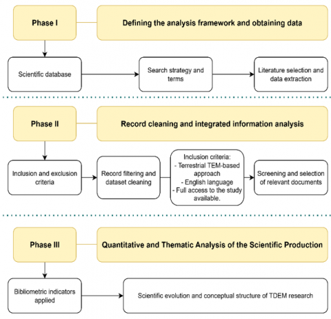
This study focuses on a qualitative and quantitative evaluation using the bibliometric method, which allows for the analysis of the development of scientific knowledge [31], research clusters, as well as emerging and declining topics related to the application of ground-based TEM in coastal aquifers [32]. The methodological diagram was organised into three study phases (Figure 1).
Figure 1. Developed methodological scheme
2.1 Phase I: Defining the analysis framework and obtaining data
For the development of this phase, only the Scopus database was considered, as it is one of the repositories with the most significant number of scientific journals compared to other databases [33]. The strategic search integrated three groups of words (transient electromagnetic, groundwater, and coastal), each with its terminological variants, and the application of Boolean operators (AND, OR) (Table 1). Additionally, owing to the different application modalities of the TEM technique, the research focuses on "ground-based" classification, which provides consistent image results while being much more economical and accessible in the field compared to airborne TEM testing [34].
The search was not limited to a specific period; it included all documentation published in the database up to the data download date of 10 June 2025, where a total of 123 documents were exported in .CSV format for organization and analysis in the tools Microsoft Excel, VOSviewer (version 1.6.20) [35], and RStudio (version 4.4.2).
Table 1. Bibliographic search design
|
Main Topics |
Keywords |
|
Transient electromagnetic (1) |
“Transient electromagnetic*”, “TDEM”, “TEM”, “Time-Domain electromagnetic”, “electromagnetic time-domain method*” |
|
Groundwater (2) |
“aquifer*”, “groundwater” |
|
Coastal (3) |
“coastal”, “littoral” |
|
Combination of Search Topics |
|
|
((TITLE-ABS-KEY (“transient electromagnetic”) OR TITLE-ABS-KEY (“TDEM”) OR TITLE-ABS-KEY (“TEM”) OR TITLE-ABS-KEY (“Time-Domain electromagnetic”) OR TITLE-ABS-KEY ("electromagnetic time-domain method*"))) AND ((TITLE-ABS-KEY ("aquifer*") OR TITLE-ABS-KEY ("groundwater"))) AND ((TITLE-ABS-KEY ("coastal") OR TITLE-ABS-KEY ("littoral"))) |
|
2.2 Phase II: Record cleaning and integrated information analysis
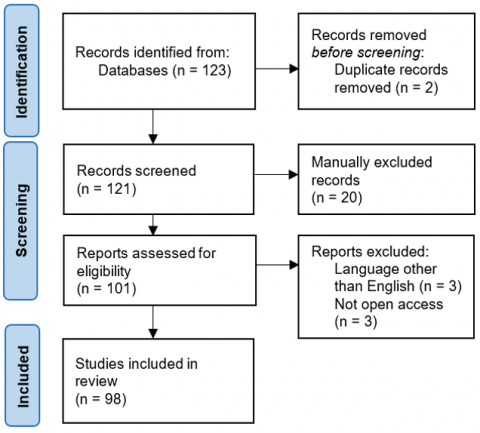
Subsequently, the downloaded database was subject to inclusion criteria such as: i) methodological approach based on ground-based TEM, ii) language in English, and iii) availability of full access to the study.
The choice of language is attributed to the fact that, within the database of 123 documents (Figure 2), 97.56% are in English, whereas Spanish and Russian account for 1.62% and 0.81%, respectively. The authors conducted the filtering process in two stages: the first consisted of reviewing the title and abstract of the record, and the second stage included a review of the entire content, focusing on studies that detail the characteristics of the TEM method in the search for groundwater in coastal regions. This process reduced the initial information base to 98 documents, which were key in the quantitative phase.
To refine the disciplinary orientation of the selected publications, a manual classification scheme was applied based on an analysis of the titles and abstracts of the 98 records. Three categories were defined as follows:
•Geophysics: studies focused on the methodological aspects of the Transient Electromagnetic Method (TEM), including data processing, inversion algorithms, resolution analysis, and instrumentation.
•Hydrogeology: Studies oriented toward the assessment of groundwater resources, aquifer characterisation, seawater intrusion, and related hydrogeological processes using TEM.
•Multidisciplinary: studies that combine geophysical methodological contributions and hydrogeological applications in an integrated manner.
Figure 2. PRISMA flow diagram applied in the study
2.3 Phase III: Quantitative and thematic analysis of the scientific production
This phase involved a bibliometric analysis using the Biblioshiny tool within RStudio software to provide an overview of the state of knowledge [36]. The variables considered were the number of publications per year, countries that contribute most to the subject, a map of the degree of relevance and development of research, and trends of the subject. Microsoft Excel (Office 265) was used for scientific production graphs, and VOSviewer was used for the occurrence network analysis [37].
A country contribution analysis was conducted using the full counting method in VOSviewer, establishing a minimum of one publication per country to understand the collaboration between countries. A total of 41 countries met the criteria, and the data were extracted to visualise their distribution on a map using ArcGIS. The full count was used because it implies that a co-authored publication is counted with a total weight of one for each co-author, meaning that its total weight is equal to the number of authors [38]. The network map and density of international collaboration were generated using the Biblioshiny tool, Walktrap was applied as a clustering algorithm, and its normalisation was through association.
To develop the keyword co-occurrence map, the full counting method was applied, the author's keywords were selected as the unit of study, and a minimum occurrence threshold of two was established to include only the most relevant terms and avoid statistical noise. The map included 30 terms grouped using the VOS clustering algorithm and normalised using the association strength method.
3.1 Temporal evolution and disciplinary distribution of ground-based TEM studies in coastal aquifers
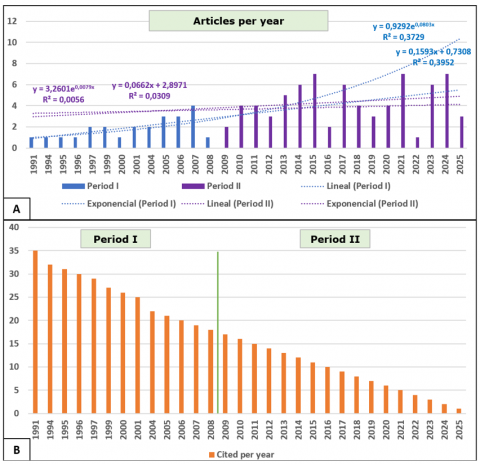
An analysis was conducted to evaluate the total number of scientific publications (TP) and the total number of citations (TC) in a database of 98 documents spanning 1991-2025. Figure 3(A) shows an increase in publications over the years, reaching its highest peak with seven publications in 2015, 2021, and 2024. However, it also indicates intermittent declines and absences of data. Figure 3(B) shows a notable progressive decrease in the number of citations; the oldest article [39] had 35 citations, and since then, it has gradually declined.
Two periods were defined: Period I (1991-2008), which exhibits low scientific production, with most cases not exceeding one article per year, and five periods with no articles; however, this is the period with the highest number of citations per article. It is characterised by evaluating the applicability of the TEM method for solving various hydrological problems [39], attempting to resolve the lack of uniqueness in the interpretation of TEM data using only measured data [40], calculating the depth of the saline-freshwater interface [41], and showing little combination of methods, such as the audiomagnetotelluric technique (AMT) [42], well data [43], and gravimetry [44].
Figure 3. (A) Scientific production or total publications (TP), (B) Number of citations or total citations (TC)
The aim of the most cited article, which is also the oldest [39], was to examine the accuracy of TEM under the specific hydrogeological conditions of the coastal aquifer and to test whether the method could replace observation well monitoring. To do so, they performed 100 TEMs over two months. Their results showed that the technique is viable for detecting the freshwater/saline interface and that the geoelectric and geological boundaries do not coincide because of groundwater salinity. They also highlighted limitations, such as the low reliability of deeper values.
Period II (2009-2025) exhibits a slight increase in scientific production, with the number of articles increasing from four to seven during this period. This period is characterised by a greater interest in the detection and impacts of saline intrusion [21, 45-49], which suggests a trend towards the conservation of freshwater coastal aquifers. In addition, they employ new combinations such as remote sensing [50, 51], geochemical analysis [52, 53], and integrate 2D and 3D modelling [54-56].
A contrasting behaviour was identified in the evolution of the scientific production of the TEM method. During period I, growth was moderate, with a linear fit (R² = 0.3952) slightly higher than the exponential (R² = 0.3729), indicating a phase of methodological consolidation. However, in period II (2009-2025), both models presented low fits (R² < 0.04), reflecting dispersed production without a clear growth trend. This behaviour shows that, despite technological advances and recent applications, the use of TEM has not experienced a sustained boom in recent years. The absence of an exponential curve reinforces the hypothesis that the field has entered a mature or specialisation phase, far from the classic pattern described by Price's Law for expanding scientific fields [57, 58].
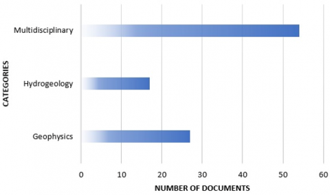
In terms of disciplinary distribution, over half of the studies (55.1%) were conducted in multidisciplinary areas, while 27.6% focused on geophysics and 17.4% on hydrogeology (Figure 4). The prevalence of these interdisciplinary approaches indicates a shift from purely methodological developments toward applied studies that address issues such as seawater intrusion, aquifer characterization, and groundwater resource management.
Figure 4. Categories of documents in the database
3.2 International scientific production
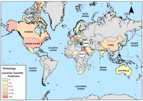
Figure 5 shows the countries participating in scientific production, with Egypt (Africa) in first place with 51 contributions, followed by Israel (Asia) with 41, the United States (Americas) with 35, Germany with 34, and Denmark (Europe) with 33 contributions. This research encompasses 41 countries; however, most contributions are focused on Egypt and Israel, which are situated near the Mediterranean Sea [59], Red Sea [60], and Dead Sea [61]. Their articles focused on determining saline intrusion zones using TEM due to excessive pumping in coastal areas, which are considered vulnerable areas. Similar objectives apply to European countries bordering the Mediterranean Sea [44] and to countries near the South China Sea [62].
Figure 5. Map of scientific contributions by country
On the other hand, in North America, studies focus on modelling coastal aquifer environments of glaciomarine deposits [63], characterisation for coastal aquifer prevention [64], and monitoring of saline intrusion [65].
3.3 International collaboration in the use of ground-based TEM
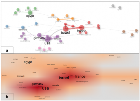
The co-authorship network (Figure 6) reveals that international collaboration is concentrated in a few scientific centres, particularly in Israel, the United States, France, Germany, Denmark, and Egypt. In contrast, Ecuador, Spain, Japan, and Tunisia appear as isolated nodes with limited collaborative ties.
Figure 6. Network (a) and density map (b) of international collaboration
While most international collaborations are concentrated in the Mediterranean Basin, Europe, and North America, our network also shows emerging but less connected contributions from South Asia (India, Sri Lanka), East Asia (China), and Oceania (Australia and New Zealand). In contrast, Southeast Asia, despite being widely recognised as a hotspot for saline intrusion in deltaic and island aquifers such as the Mekong Delta (Vietnam), Kelantan (Malaysia), and Manila Bay (Philippines), was poorly represented in the bibliometric dataset. This gap is critical, as many aquifers in these regions are highly vulnerable to seawater intrusion [66, 67].
3.4 Research areas in the use of the ground-based TEM method in the characterization of coastal aquifers
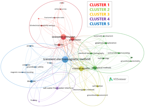
The co-occurrence analysis of author keywords (Figure 7) revealed five main thematic clusters related to the application of the TEM method in coastal environments, as identified by plotting 30 keywords with a minimum occurrence of two. The most active research areas revolve around saline intrusion, hydrogeological assessment, and coastal aquifer monitoring, with strong methodological links and environmental applications in the field. The clusters identified in this study are described in detail in the following sections.
Figure 7. Keyword co-occurrence map
Cluster 1: Saline-brackish water infiltration and 2D/3D modelling
Marine intrusion represents one of the largest nodes in the clusters, indicating a high recurrence of studies focusing on detecting and delimiting saline intrusion. This factor increases owing to excessive pumping in coastal regions [68] and affects the water quality in areas with high water demand for human consumption, tourism, and crop irrigation [65, 69, 70].
In the study of this phenomenon, ground-based and airborne TEM techniques were combined [71], generating 1D and 2D section models of the salt wedge [63, 72]. 3D models of the aquifer have been developed through geophysical exploration campaigns of more than 100 TEM surveys [69]. Additionally, in this cluster, TEM was used to assess the impact of prolonged pumping and its capacity to reverse the hydraulic gradient, thereby facilitating seawater penetration [65]. There is research that allows cross-validation between subsurface electrical properties and the physicochemical parameters of water [53]. Studies in this cluster have fostered the development of models that integrate geophysical and geochemical data, facilitating a more precise understanding of coastal aquifer system dynamics.
This cluster presents an intense concentration of studies from Greece, distinguished by the integration of TEM with numerical flow and density models (such as FEFLOW or 3D resistivity) to address saline intrusion in coastal aquifers [69, 70]. Canada uses TEM to characterise glacial deposits and basement topographies [63]. In addition to TEM, France uses total magnetic intensity, geological, and hydrogeological data from boreholes to analyse the structure and functioning of coastal aquifers [73].
Cluster 2: GIS and a combination of methods for hydrogeological modelling
This group of terms is represented by “geophysical methods”, “vertical electrical sounding”, “geophysical exploration”, “electrical resistivity tomography”, “hydrogeology”, and “GIS”. Research highlights the combination and correlation of the TEM technique with geophysical methods, including VES and ERT, to generate hydrogeological models before drilling [74]. Additionally, studies use Geographic Information Systems (GIS) tools to identify and create maps of Groundwater Potential Zones (GWPZs) using the Analytical Hierarchy Process (AHP) technique [24, 75]. Complementarily, remote sensing has been used to quantify coastline change rates, estimating areas gained or revealing considerable retreat due to erosion [76]. This cluster also suggests that the term “sustainable development” is closely related to the TEM method due to its non-invasive characteristics and effectiveness in evaluating aquifer capacity and determining the success or failure of future drilling plans [77]. These studies demonstrate the versatility of TEM, from its integration with GIS and remote sensing to its contribution in regions without wells, which enables the identification of strategic extraction points.
In this cluster, most affiliations were from Egypt, reflecting their leadership in the application of VES and TEM, in combination with remote sensing (Landsat), RS, and GIS, to assess groundwater availability in arid areas [51, 53, 76]. Ecuador stands out in the application of VES and TEM to map potential areas for sustainable groundwater exploitation [24]. Greece plays a significant role in the combined use of ERT and TEM for assessing coastal aquifers [74].
Cluster 3: Impact of salinization on coastal aquifers
This cluster presents a greater occurrence in the term “coastal aquifer”, associated with terms such as “salinisation”, “electromagnetic methods”, and “groundwater assessment”. This group of words indicates articles that relate TEM with the protection of coastal aquifers against salinisation, where the technique is used to detect and size the saline plume [78]. Additionally, TEM has been utilised to assess the infiltration of brine from oil fields into aquifers, aided by chemical tracers [79]. Likewise, they focus on evaluating the quality and quantity of groundwater before initiating a development plan for the water supply of coastal regions [80].
This cluster is dominated by Egypt, where the integration of VES and TEM in the study of marine intrusion and groundwater quality in coastal areas predominates [80, 81], and Germany, which investigates the presence and spatial extent of saline water intrusion using TEM [21]. Relevant contributions also appear from Japan and Tunisia, with joint work applying TEM and geochemical tracers [79].
Cluster 4: Dynamics between the freshwater/saltwater interface
Cluster IV presents two closely related terms: "saltwater-freshwater interface" and "flushing." Flushing refers to the displacement of saltwater residues from the Dead Sea caused by the rise and fall of sea levels. Its replacement occurs through the infiltration of freshwater from rivers and meteoric waters, thereby increasing the groundwater recharge. The TEM method was employed because of its ability to detect the low resistivity contrast between freshwater and saltwater, thereby determining the location of the interface and its irregularities, which are attributed to fluctuations in the Dead Sea and the existence of subaquifers [43, 82, 83]. TEM geophysical exploration campaigns enable the development of three-dimensional flow geomodels to simulate saline intrusion and determine its association with anthropogenic processes, such as overpumping, thereby becoming a tool for informed decision-making in policy management and climate change [84].
Cluster 4 is represented by Israel, where TEM-based studies combined with hydrogeological modelling (FEFLOW) predominate, focusing primarily on coastal aquifer dynamics in the Dead Sea area [43, 68]. India contributes by combining geophysical methods, including TEM, VES, ERT, and well logging, to delineate fresh and saline groundwater [85]. Finally, Saudi Arabia seeks to delineate marine intrusion in arid areas using TEM [45].
In this sense, the importance of TEM as a monitoring tool is linked to international initiatives such as the Groundwater Summit 2024, which promotes sustainable management. An example is the Arkansas Department of Agriculture (U.S.) [86], which recommends moving toward sustainable pumping by designating critical groundwater zones. This measure encourages conservation by offering tax incentives, expanding educational outreach, and facilitating access to federal programs and funding. The incorporation of these approaches demonstrates how the results of hydrogeophysical studies can extend beyond academic research and inform public policy decisions aimed at achieving water sustainability.
Cluster 5: Integration of TEM with other methods in early Mediterranean studies
According to the occurrence map, this cluster links the TEM method with other lesser-known techniques, such as Magnetic Resonance Sounding (MRS) and Direct Current-Time Domain Induced Polarisation (DC-TDIP). Some investigations have utilised TEM for sinkhole detection because of its sensitivity in identifying conductive zones associated with the rapid dissolution of salt and the creation of underground caverns [87].
Israel leads this cluster, followed by France, Germany, and Jordan. Israel combines TEM with a wide variety of geophysical methods (seismic, SNMR, MRS, microgravity, and MASW) to study salt intrusion and sinkhole development in the Dead Sea region [88, 89]. Jordan and France participated in joint research with Israel, reflecting a more pronounced international collaboration in this cluster [87, 90]. Germany, on the other hand, incorporates Differential Electric Dipole (DED), GPR, and Long-Offset Transient Electromagnetics (LOTEM), generally linked to coastal and marine environments [91, 92].
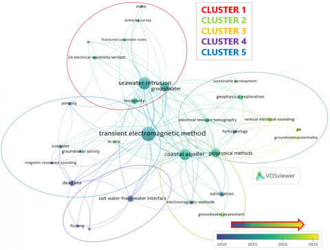
3.5 Temporal evolution of research areas
Figure 8 shows the temporal evolution of the five research clusters obtained in Figure 7. Around 2010, the terms in clusters 4 and 5 indicated a trend toward the use of TEM techniques near the Dead Sea to delineate interface zones. Between 2015 and 2020, the emphasis was placed on detecting marine intrusion affecting coastal aquifer systems, with 2D models being the most common method for obtaining a more accurate visual representation of the salt wedge. Currently, this geophysical technique is associated with the management and conservation of coastal aquifers in the region.
Figure 8. Keyword co-occurrence map over time
3.6 Thematic dynamics of TEM research in coastal environments
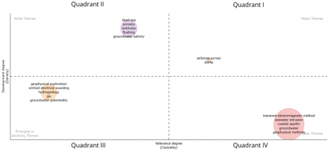
The thematic cluster diagram is presented in Figure 9, which is classified into four quadrants: Motor Themes (Quadrant I), Niche Themes (Quadrant II), Emerging or Declining Themes (Quadrant III), and Basic Themes (Quadrant IV). This diagram reveals the centrality and density of various themes (author keywords), offering key information on the successes and challenges of the research [93]. In the motor themes, we have “airborne survey” and “pump”, which indicate high relevance and density; however, the size of the circle reflects their low capacity to represent interrelationships within the network [94]. This is because the “airborne survey” subtheme is not the primary modality of the study; however, there are investigations that combine airborne and ground-based TEM methods for the characterisation of coastal aquifers [95], which suggests an evolution of the technique to facilitate the increase in the spatial coverage of the investigated area and data acquisition. The appearance of the term “pump” reflects a key line towards overexploitation, which is one of the factors that promote saline intrusion [96].
Figure 9. Map of the degree of relevance and development of the TEM method for searching for groundwater in arid coastal areas
“Dead Sea”, “porosity”, “sinkhole”, “flushing”, and “groundwater salinity” are grouped in the Niche Themes quadrant (II). They are specific topics with high specialisation but moderate connection to the subject of study. The strategic value of the issues “flushing” and “groundwater salinity” is associated with the research of Yechieli et al. [43], who studied the fluctuations in the level of the Dead Sea and determined by applying TEM and geochemical analysis that the freshwater-saltwater interface has not been thoroughly washed away. Using the TEM method, they detected saline remains near the sea at a depth of -400 m, which can be attributed to the high lake level in the late 1970s. In parallel, studies have been conducted to quantitatively evaluate the interstitial spaces of brine contained in pores in regions near the Dead Sea [88]. Furthermore, marine intrusion and its association with sinkholes represent a serious threat to human life and development in coastal zones [61].
The third quadrant includes the topics “geophysical exploration,” “vertical electrical sounding,” “hydrogeology,” “GIS,” and “groundwater potential.” To determine whether the topics are emerging or declining, the timeline keyword map developed in VOSviewer (Figure 8) was considered. These are emerging terms in ground-based TEM research spanning 2020-2025. Parameters such as precipitation, slope, and drainage density were integrated using GIS to create a map of potential groundwater zones, in combination with resistivity values obtained with VES and/or TEM, to estimate zones that favour infiltration [75].
Quadrant IV includes the terms "TEM," "seawater intrusion," "coastal aquifer," "groundwater," and "geophysical methods." This cluster represents the core of the research, demonstrating high relevance, and the node size is associated with a strong connection to other topics. However, a low density (i.e., a decreasing number of articles) is observed, so there remains an opportunity to explore, develop, and delve deeper into the topics. The presence of the terms TEM and geophysical methods in a single node implies that TEM surveys are insufficient to obtain a robust aquifer extension.
3.7 Main challenges and gaps in ground-based TEM geophysical investigation of coastal aquifers
The ground-based TEM method has several benefits for mapping saline zones and evaluating freshwater-saltwater interfaces to depths of ~300 m, thereby overcoming the limitations of other electrical methods, such as VES, in highly conductive materials [81]. TEM test setups are characterised by their simplicity of implementation in the field, requiring only a single transmitter loop and one or two receiver coils. Installation does not require galvanic contact, unlike other methods (e.g., SEV or ERT), which often fail in dry or high-resistivity subsurface. However, this study identified essential limitations that have been reported in the scientific literature.
a. The degradation of recording quality due to urban electromagnetic noise, originating from power lines or pipelines [47], can be addressed by correlated noise stacking, which improves the signal-to-noise ratio [97]. However, future studies are needed to address the energy consumption issues associated with the stacking process [97].
b. The low sensitivity to thin resistive layers, such as laterites, makes it challenging to detect formations that are critical for recharge or aquifer sealing [98-100].
c. Distortion is caused by multiple complex hydrogeological conditions (saline mixing, seasonal recharge, fault impact, and coastal climate), which require sophisticated modelling and multiscale inverts [101].
d. The limited lateral scaling in airborne TEM surveys reduces their spatial resolution (200 m between points), making them useful over large areas but with high uncertainty in local details [71, 101].
Despite these limitations, the TEM method has been applied in alluvial aquifer settings [71, 85], volcanic [56, 72, 98], and in the identification of saline intrusion pathways associated with faults (Table 2) [69, 101, 102], when complemented with additional geophysics (ERT, IP, structural geology).
Table 2. Application of TEM in different geological environments
| Geological Context | TEM Application | DOI |
| Sedimentar/Alluvial | Identification of the presence of hydraulic communication between a free saline aquifer and a confined freshwater aquifer. | 10.1190/GEO2012-0004.1 |
| Carbonates/Karst | Definition of the shape and thickness of the water lens beneath the carbonate plateau. | 10.1007/BF03175403 |
| Crystalline/metamorphic basement | Compatible prospecting in a young volcanic environment and improved groundwater management approach. | 10.1007/978-3-642-31395-0_24 |
| Volcanic (basalts, tuffs, lavas) | Detection of paleochannels under lava flows. | 10.1111/j.1745-6584.1997.tb00123.x |
| Offshore Marine | Detection of connection between marine system and terrestrial aquifer system. | 10.3389/fmars.2020.531293 |
There are still gaps related to multiscale data integration (joint inversion of TEM-ERT-IP) [72, 103], temporal validation for monitoring dynamic changes in coastal interface zones [104], and coupled numerical modelling that includes heterogeneities, subsidence, and climate change [68].
A trend was also observed in the use of TEM information in the assessment, strategic planning, and protection of aquifers in coastal cities that are vulnerable to saline intrusion [105]. They can even help plan future drilling operations, providing a non-destructive and low-cost alternative for coastal aquifer management [64].
The use of this technique is currently booming in the understanding, protection, and enhancement of coastal groundwater resources [100], as well as in the implementation of management strategies such as pollution regulations, the detection and utilisation of freshwater recharge zones, and the promotion of sustainable agriculture [106].
This study evaluated 98 documents from the Scopus database on groundwater exploration in coastal areas using the ground-based Time-Domain Electromagnetic Method (TDEM). Scientific production over 34 years has shown a scattered increase with no discernible trend, indicating that the TEM method is in a mature or specialised phase. Furthermore, the scientific contribution map revealed that the Mediterranean, Dead, and Red Seas influence countries such as Egypt and Israel because of their proximity to these seas, making them vulnerable to saltwater intrusion. This issue has driven multiple investigations in this region.
The ground-based TEM method reaches depths of up to 300 m. Additionally, five research areas were identified, focusing on saline-brackish water infiltration and 2D and 3D modelling, a combination of methods for hydrogeological modelling, the impact of salinisation on coastal aquifers, the dynamics of the freshwater/saltwater interface, and integration of TEM with other methods in early Mediterranean studies. However, limitations persist in the detection of thin resistive layers and urban noise management, underscoring the importance of integrating TEM with complementary methods (VES, ERT, MRS, and DC-TDIP) and well data.
However, significant research gaps persist. Some studies suggest intervals of several years for stable systems and a need for seasonal monitoring in dynamic aquifers. Furthermore, very few studies explicitly consider climate change scenarios, such as sea level rise or hydrological variability, despite their importance for the long-term resilience of aquifers. Standardizing monitoring frequencies and integrating climate pressures are key to advancing TEM into a tool for sustainable groundwater management under future change.
We acknowledge the research project titled "Registry of geological interest sites of Ecuador for sustainable development strategies" with institutional code CIPAT-004-2024 for its support and contributions to this study.
[1] Rekha, P., Kamalakkannan, M.K., Selvakumar, P., Bhattacharya, S. (2024). Ground water management. Advances in Environmental Engineering and Green Technologies, pp. 149-174. https://doi.org/10.4018/979-8-3693-6920-3.ch005
[2] Bandh, S.A., Mushtaq, B. (2025). Drinking water treatment process. In Wastewater Treatment Technology. Springer Water, pp. 165-227. https://doi.org/10.1007/978-3-031-86684-5_3
[3] Xian, J., He, Z., Hu, X., Liu, L., Auken, E., Revil, A., Cai, H. (2025). Groundwater mapping and modeling using towed transient electromagnetic data based on deep learning. IEEE Transactions on Geoscience and Remote Sensing, 63: 1-12. https://doi.org/10.1109/tgrs.2024.3509526
[4] Carrión-Mero, P., Olaya, P., Sanango-Ochoa, L., Cano-Alvarado, F., Bravo-Montero, Lady, Solórzano, J., Morante-Carballo, F. (2023). Hydrogeological characterization of a coastal area for the groundwater exploitation. Hondo River Micro-Watershed, Santa Elena-Ecuador. International Journal of Sustainable Development and Planning, 18(2): 401-410. https://doi.org/10.18280/ijsdp.180208
[5] Intergovernmental Panel on Climate Change (IPCC). (2023). Water. In Climate Change 2022-Impacts, Adaptation and Vulnerability: Working Group II Contribution to the Sixth Assessment Report of the Intergovernmental Panel on Climate Change, pp. 551-712. https://doi.org/10.1017/9781009325844.006
[6] Adams, K.H., Reager, J.T., Buzzanga, B.A., David, C.H., Sawyer, A.H., Hamlington, B.D. (2024). Climate-induced saltwater intrusion in 2100: Recharge-driven severity, sea level-driven prevalence. Geophysical Research Letters, 51(22): e2024GL110359. https://doi.org/10.1029/2024gl110359
[7] Closson, D., Djamil, A.H. (2025). Remote sensing and geophysical applications in the Dead Sea region: Insights, trends, and advances. Geosciences, 15(2): 50. https://doi.org/10.3390/geosciences15020050
[8] Chang, J., Wu, X., Lei, K., Lv, P., Zhao, Y., Meng, Q. (2022). Three-dimensional modeling of ground-airborne transient electromagnetic responses of typical models based on the finite difference approach. Journal of Applied Geophysics, 197: 104545. https://doi.org/10.1016/j.jappgeo.2022.104545
[9] Schamper, C., Pedersen, J.B., Auken, E., Christiansen, A.V., Vittecoq, B., et al. (2013). Airborne transient EM methods and their applications for coastal groundwater investigations. In Groundwater in the Coastal Zones of Asia-Pacific. Coastal Research Library, pp. 121-153. https://doi.org/10.1007/978-94-007-5648-9_7
[10] Wu, J., Li, X., Zhi, Q., Deng, X., Guo, J. (2016). Full field apparent resistivity definition of borehole TEM with electric source. In Proceedings of the 7th International Conference on Environment and Engineering Geophysics and Summit Forum of Chinese Academy of Engineering on Engineering Science and Technology, pp. 152-155. https://doi.org/10.2991/iceeg-16.2016.42
[11] Nabighian, M.N., Macnae, J.C. (1991). 6-time domain electromagnetic prospecting methods. In Electromagnetic Methods in Applied Geophysics, pp. 427-520. https://doi.org/10.1190/1.9781560802686.ch6
[12] Cook, P.G., Hughes, M.W., Walker, G.R., Allison, G B. (1989). The calibration of frequency-domain electromagnetic induction meters and their possible use in recharge studies. Journal of Hydrology, 107(1-4): 251-265. https://doi.org/10.1016/0022-1694(89)90060-7
[13] Christiansen, A.V., Auken, E., Sørensen, K. (2009). The transient electromagnetic method. In Groundwater Geophysics, pp. 179-226. https://doi.org/10.1007/978-3-540-88405-7_6
[14] Fitterman, D.V., Stewart, M.T. (1986). Transient electromagnetic sounding for groundwater. Geophysics, 51(4): 995-1005. https://doi.org/10.1190/1.1442158
[15] Carrasquilla, A.A.G., Ulugergerli, E. (2006). Evaluation of the transient electromagnetic geophysical method for stratigraphic mapping and hydrogeological delineation in Campos Basin, Brazil. Revista Brasileira de Geofísica, 24(3): 333-341. https://doi.org/10.1590/s0102-261x2006000300003
[16] Francés, A.P., Ramalho, E.C., Monteiro Santos, F., Llorente, J.M., Mateus, T., et al. (2024). Contribution of the time domain electromagnetic method to the study of the Kalahari transboundary multilayered aquifer systems in Southern Angola. Hydrogeology Journal, 32(6): 1709-1727. https://doi.org/10.1007/s10040-024-02822-x
[17] Xie, H., Guo, Y., Li, G., Li, J., Liu, R., Liang, Y. (2025). Laterally constrained inversion of time-domain transient electromagnetic data and using it for detecting water-rich zones in coal mines. Mine Water and the Environment, 44(2): 502-512. https://doi.org/10.1007/s10230-025-01036-1
[18] Carrasco-García, J., Porras-Sanchiz, D., Carrasco-García, P., Herrero-Pacheco, J.L., Martín-Nieto, I., Benito-Herrero, J.M., Huerta-Hurtado, P. (2022). Time-domain electromagnetics as a geophysical tool in hydrogeological exploitation projects in Mesozoic formations. Applied Sciences, 12(17): 8655. https://doi.org/10.3390/app12178655
[19] Wu, J., Xiao, D., Du, B., Liu, Y., Zhi, Q., Wang, X., Deng, X., Chen, X., Zhao, Y., Huang, Y. (2024). Exploring shallow geological structures in landslides using the semi-airborne transient electromagnetic method. Remote Sensing, 16(17): 3186. https://doi.org/10.3390/rs16173186
[20] Ma, Z., Di, Q., Lei, D., Gao, Y., Zhu, J., Xue, G. (2020). The optimal survey area of the semi-airborne TEM method. Journal of Applied Geophysics, 172: 103884. https://doi.org/10.1016/j.jappgeo.2019.103884
[21] Bou-Rabee, F., Yogeshwar, P., Burberg, S., Tezkan, B., Duane, M., Ibraheem, I.M. (2025). Imaging of groundwater salinity and seawater intrusion in Subiya Peninsula, Northern Kuwait, using transient electromagnetics. Water, 17(5): 652. https://doi.org/10.3390/w17050652
[22] Zhu, Z., Shan, Z., Pang, Y., Wang, W., Chen, M., Li, G., Sun, H., Revil, A. (2024). The transient electromagnetic (TEM) method reveals the role of tectonic faults in seawater intrusion at Zhoushan islands (Hangzhou Bay, China). Engineering Geology, 330: 107425. https://doi.org/10.1016/j.enggeo.2024.107425
[23] Junique, T., Fauchard, C., Antoine, R., Guilbert, V., Beaucamp, B., et al. (2023). Investigation of the hydrogeology at a chalk cliff site in normandy using multiple research approaches. In NSG2023 2nd Conference on Hydrogeophysics, Edinburgh, United Kingdom, pp. 1-5. https://doi.org/10.3997/2214-4609.202320027
[24] Carrión-Mero, P., Solórzano, J., Malavé-Hernández, J., Martínez-Angulo, J., Javier, M. F., Morante-Carballo, F. (2024). Mapping groundwater potential zones for sustainable agricultural development in Entre Ríos, Ecuador. International Journal of Design & Nature and Ecodynamics, 19(3): 817-830. https://doi.org/10.18280/ijdne.190312
[25] Briones-Bitar, J., Pinto-Ponce, B., Caicedo-Potosí, J., Santos-Baquerizo, E., Carrión-Mero, P., Morante-Carballo, F. (2025). Evolution of smart buildings: A bibliometric analysis and systematic review. International Journal of Sustainable Development and Planning, 20(4): 1369. https://doi.org/10.18280/ijsdp.200403
[26] Yang, Y., Yang, F., Wang, B., Qian, W., Wang, Y., Zuo, Y. (2025). Technical analysis and application prospects of magnetic source transient electromagnetic coil devices in hydrogeological survey of mining area. Water, 17(2): 171. https://doi.org/10.3390/w17020171
[27] Chang, J., Xue, J., Meng, Q., Li, H. (2024). Research progress in three-dimensional forward modeling for the transient electromagnetic method. Journal of Geophysics and Engineering, 21(6): 1764-1774. https://doi.org/10.1093/jge/gxae104
[28] Chakraborty, R., Khan, K.M., Dibaba, D.T., Khan, M.A., Ahmed, A., Islam, M.Z. (2019). Health implications of drinking water salinity in coastal areas of Bangladesh. International Journal of Environmental Research and Public Health, 16(19): 3746. https://doi.org/10.3390/ijerph16193746
[29] Van Weert, F., Van der Gun, J., Reckman, J.W.T.M. (2009). Global overview of saline groundwater occurrence and genesis. International Groundwater Resources Assessment Centre.
[30] Reimann, L., Vafeidis, A.T., Honsel, L.E. (2023). Population development as a driver of coastal risk: Current trends and future pathways. Cambridge Prisms: Coastal Futures, 1: e14. https://doi.org/10.1017/cft.2023.3
[31] Carrión-Mero, P., Brito-Matamoros, R., Jaya-Montalvo, M., Morante-Carballo, F., Berrezueta, E., Velastegui-Montoya, A. (2024). Bibliometric analysis of the effects of aquaculture on mangrove forests. International Journal of Design & Nature and Ecodynamics, 19(6): 2023-2039. https://doi.org/10.18280/ijdne.190619
[32] Bording, T., Christiansen, A.V., Auken, E., Gunnink, J.L., Oude Essink, G.H. (2017). Groundbased TEM survey in the subsiding mekong delta. In 23rd European Meeting of Environmental and Engineering Geophysics, Malmö, Sweden, pp. 1-5. https://doi.org/10.3997/2214-4609.201701991
[33] Medias, F., Rosari, R., Susamto, A.A., Ab Rahman, A.B. (2023). A bibliometric analysis on innovation in philanthropy research: A study based on Scopus database. International Journal of Innovation Science, 16(4): 748-771. https://doi.org/10.1108/ijis-08-2022-0139
[34] Madsen, L.M., Bording, T., Grombacher, D., Foged, N., Foley, N., et al. (2022). Comparison of ground-based and airborne transient electromagnetic methods for mapping glacial and permafrost environments: Cases from McMurdo Dry Valleys, Antarctica. Cold Regions Science and Technology, 199: 103578. https://doi.org/10.1016/j.coldregions.2022.103578
[35] VOSviewer. VOSviewer. https://www.vosviewer.com/, accessed on Jun. 21, 2025.
[36] Ghorbani, B.D. (2024). Bibliometrix: Science mapping analysis with R biblioshiny based on web of science in applied linguistics. A Scientometrics Research Perspective in Applied Linguistics, pp. 197-234. https://doi.org/10.1007/978-3-031-51726-6_8
[37] Mulet-Forteza, C., Socias Salvá, A., Monserrat, S., Amores, A. (2019). 80th anniversary of pure and applied geophysics: A bibliometric overview. Pure and Applied Geophysics, 177(2): 531-570. https://doi.org/10.1007/s00024-019-02328-8
[38] Perianes-Rodriguez, A., Waltman, L., van Eck, N.J. (2016). Constructing bibliometric networks: A comparison between full and fractional counting. Journal of Informetrics, 10(4): 1178-1195. https://doi.org/10.1016/j.joi.2016.10.006
[39] Goldman, M., Gilad, D., Ronen, A., Melloul, A. (1991). Mapping of seawater intrusion into the coastal aquifer of Israel by the time domain electromagnetic method. Geoexploration, 28(2): 153-174. https://doi.org/10.1016/0016-7142(91)90046-f
[40] Goldman, M., Du Plooy, A., Eckard, M. (1994). On reducing ambiguity in the interpretation of transient electromagnetic sounding data. Geophysical Prospecting, 42(1): 3-25. https://doi.org/10.1111/j.1365-2478.1994.tb00192.x
[41] Martínez, M.I., Troester, J.W., Richards, R.T. (1995). Surface electromagnetic geophysical exploration of the ground-water resources of Isla de Mona, Puerto Rico, a Caribbean carbonate Island. Carbonates and Evaporites, 10(2): 184-192. https://doi.org/10.1007/bf03175403
[42] Robineau, B., Ritz, M., Courteaud, M., Descloitres, M. (1997). Electromagnetic investigations of aquifers in the grand Brulé coastal area of Piton de la Fournaise Volcano, Reunion Island. Groundwater, 35(4): 585-592. https://doi.org/10.1111/j.1745-6584.1997.tb00123.x
[43] Yechieli, Y., Kafri, U., Goldman, M., Voss, C. (2001). Factors controlling the configuration of the fresh-saline water interface in the Dead Sea coastal aquifers: Synthesis of TDEM surveys and numerical groundwater modeling. Hydrogeology Journal, 9(4): 367-377. https://doi.org/10.1007/s100400100146
[44] Duque, C., Calvache, M.L., Pedrera, A., Martín-Rosales, W., López-Chicano, M. (2008). Combined time domain electromagnetic soundings and gravimetry to determine marine intrusion in a detrital coastal aquifer (Southern Spain). Journal of Hydrology, 349(3-4): 536-547. https://doi.org/10.1016/j.jhydrol.2007.11.031
[45] Al-Garni, M.A., El-Kaliouby, H.M. (2009). Delineation of saline groundwater and sea water intrusion zones using transient electromagnetic (TEM) method, Wadi Thuwal area, Saudi Arabia. Arabian Journal of Geosciences, 4(3-4): 655-668. https://doi.org/10.1007/s12517-009-0094-5
[46] Trabelsi, F., Mammou, A.B., Tarhouni, J., Piga, C., Ranieri, G. (2012). Delineation of saltwater intrusion zones using the time domain electromagnetic method: the Nabeul-Hammamet coastal aquifer case study (NE Tunisia). Hydrological Processes, 27(14): 2004-2020. https://doi.org/10.1002/hyp.9354
[47] El-Kaliouby, H., Abdalla, O. (2015). Application of time-domain electromagnetic method in mapping saltwater intrusion of a coastal alluvial aquifer, North Oman. Journal of Applied Geophysics, 115: 59-64. https://doi.org/10.1016/j.jappgeo.2015.02.003
[48] Ziadi, A., Hariga, N.T., Tarhouni, J. (2017). Use of time-domain electromagnetic (TDEM) method to investigate seawater intrusion in the Lebna coastal aquifer of eastern Cap Bon, Tunisia. Arabian Journal of Geosciences, 10(22): 492. https://doi.org/10.1007/s12517-017-3265-9
[49] Ez-zaouy, Y., Bouchaou, L., Schreiber, H., Montcoudiol, N., Kalberkamp, U., et al. (2023). Combined geophysical methods to investigate seawater intrusion in the Souss-Massa coastal area, Morocco. Groundwater for Sustainable Development, 21: 100915. https://doi.org/10.1016/j.gsd.2023.100915
[50] Kotb, A.D.M., Nabeh, M., Adham, A. (2021). Integrated remote sensing, VES, and TEM to evaluate the Rafah coastal aquifers for sustainable development—A case study. Arabian Journal of Geosciences, 14(17): 1697. https://doi.org/10.1007/s12517-021-08106-y.
[51] Elewa, H.H., Nosair, A.M., Ibrahim, A., Zelenakova, M., Pietrucha-Urbanik, K., et al. (2024). Use of remote sensing, spatial and geophysical modeling, and real recharging capabilities to identify suitable areas for groundwater exploitation in dry coastal areas. Journal of Environmental Management, 363: 121243. https://doi.org/10.1016/j.jenvman.2024.121243
[52] Kalisperi, D., Soupios, P., Kershaw, S., Kouli, M., Barsukov, P., et al. (2014). Geophysical and geochemical study of geropotamos aquifer in the north-central coast of Crete, Greece. In Near Surface Geoscience 2014-20th European Meeting of Environmental and Engineering Geophysics, Athens, Greece, pp. 1-5. https://doi.org/10.3997/2214-4609.20142009
[53] Zarif, F., Isawi, H., Elshenawy, A., Eissa, M. (2021). Coupled geophysical and geochemical approach to detect the factors affecting the groundwater salinity in coastal aquifer at the area between Ras Sudr and Ras Matarma area, South Sinai, Egypt. Groundwater for Sustainable Development, 15: 100662. https://doi.org/10.1016/j.gsd.2021.100662
[54] Goldman, M., Levi, E., Tezkan, B., Yogeshwar, P. (2011). The 2D coastal effect on marine time domain electromagnetic measurements using broadside dBz/dt of an electrical transmitter dipole. Geophysics, 76(2): F101-F109. https://doi.org/10.1190/1.3525276
[55] Martorana, R., Lombardo, L., Messina, N., Luzio, D. (2013). Integrated geophysical survey for 3D modelling of a coastal aquifer polluted by seawater. Near Surface Geophysics, 12(1): 45-59. https://doi.org/10.3997/1873-0604.2013006
[56] Pondthai, P., Everett, M.E., Micallef, A., Weymer, B.A., Faghih, Z., et al. (2020). 3D Characterization of a coastal freshwater aquifer in se Malta (Mediterranean Sea) by time-domain electromagnetics. Water, 12(6): 1566. https://doi.org/10.3390/w12061566
[57] Price, D.J.D.S. (1963). Little Science, Big Science. Columbia University Press.
[58] Ríos Riquelme, M., Denche-Zamorano, Á., Salas-Gómez, D., Castillo-Paredes, A., Ferrari, G., et al. (2025). Trends and scientific production on isometric training: A bibliometric analysis. Sports, 13(5): 145. https://doi.org/10.3390/sports13050145
[59] Shtivelman, V., Goldman, M. (2000). Integration of shallow reflection seismics and time domain electromagnetics for detailed study of the coastal aquifer in the Nitzanim area of Israel. Journal of Applied Geophysics, 44(2-3): 197-215. https://doi.org/10.1016/s0926-9851(98)00053-6
[60] Alharbi, S.S., Qaysi, S.I., Elwaheidi, M.M. (2022). Hydrogeophysical characterization of the Southern Red Sea coastal aquifer, Saudi Arabia, using Time-Domain electromagnetic method. Human and Ecological Risk Assessment: An International Journal, 29(2): 449-462. https://doi.org/10.1080/10807039.2022.2104693
[61] Ezersky, M., Goretsky, I. (2014). Velocity-resistivity versus porosity-permeability inter-relations in Dead Sea salt samples. Engineering Geology, 183: 96-115. https://doi.org/10.1016/j.enggeo.2014.09.009
[62] Tran, L.T., Larsen, F., Pham, N.Q., Christiansen, A.V., Tran, N., et al. (2012). Origin and extent of fresh groundwater, salty paleowaters and recent saltwater intrusions in Red River flood plain aquifers, Vietnam. Hydrogeology Journal, 20(7): 1295-1313. https://doi.org/10.1007/s10040-012-0874-y
[63] Simard, P.T., Chesnaux, R., Rouleau, A., Daigneault, R., Cousineau, P.A., et al. (2015). Imaging quaternary glacial deposits and basement topography using the transient electromagnetic method for modeling aquifer environments. Journal of Applied Geophysics, 119: 36-50. https://doi.org/10.1016/j.jappgeo.2015.05.006
[64] Nenna, V., Herckenrath, D., Knight, R., Odlum, N., McPhee, D. (2013). Application and evaluation of electromagnetic methods for imaging saltwater intrusion in coastal aquifers: Seaside Groundwater Basin, California. Geophysics, 78(2): B77-B88. https://doi.org/10.1190/geo2012-0004.1
[65] Torres-Martinez, J.A., Mora, A., Ramos-Leal, J.A., Morán-Ramírez, J., Arango-Galván, C., Mahlknecht, J. (2019). Constraining a density-dependent flow model with the transient electromagnetic method in a coastal aquifer in Mexico to assess seawater intrusion. Hydrogeology Journal, 27(8): 2955-2972. https://doi.org/10.1007/s10040-019-02024-w
[66] Aris, A.Z., Abdullah, M.H., Kim, K.W., Praveena, S.M. (2008). Hydrochemical changes in a small tropical island’s aquifer: Manukan Island, Sabah, Malaysia. Environmental Geology, 56(8): 1721-1732. https://doi.org/10.1007/s00254-008-1275-3
[67] Insigne, S.L., Kim, G.S. (2010). Saltwater intrusion modeling in the aquifer bounded by Manila Bay and Parañaque River, Philippines. Environmental Engineering Research, 15(2): 117-121. https://doi.org/10.4491/eer.2010.15.2.117
[68] Tal, A., Weinstein, Y., Wollman, S., Goldman, M., Yechieli, Y. (2018). The Interrelations between a Multi-Layered Coastal Aquifer, a Surface Reservoir (Fish Ponds), and the Sea. Water, 10(10): 1426. https://doi.org/10.3390/w10101426
[69] Kalisperi, D., Kouli, M., Vallianatos, F., Soupios, P., Kershaw, S., Lydakis-Simantiris, N. (2018). A transient electromagnetic (TEM) method survey in north-central coast of Crete, Greece: Evidence of seawater intrusion. Geosciences, 8(4): 107. https://doi.org/10.3390/geosciences8040107
[70] Kourgialas, N.N., Dokou, Z., Karatzas, G.P., Panagopoulos, G., Soupios, P., Vafidis, A., Manoutsoglou, E., Schafmeister, M. (2015). Saltwater intrusion in an irrigated agricultural area: Combining density-dependent modeling and geophysical methods. Environmental Earth Sciences, 75(1): 15. https://doi.org/10.1007/s12665-015-4856-y
[71] Persson, L., Erlström, M. (2015). Geophysical imaging of Silurian carbonates by use of ground and airborne electromagnetic and radiometric methods on the island of Gotland, Sweden. Interpretation, 3(3): SY1-SY11. https://doi.org/10.1190/int-2014-0186.1
[72] Bourhane, A., Comte, J.C., Join, J.L., Ibrahim, K. (2015). Groundwater prospection in Grande Comore Island—joint contribution of geophysical methods, hydrogeological time-series analysis and groundwater modelling. In Active Volcanoes of the Southwest Indian Ocean. Active Volcanoes of the World. Springer, Berlin, Heidelberg, pp. 385-401. https://doi.org/10.1007/978-3-642-31395-0_24
[73] Vittecoq, B., Reninger, P.A., Violette, S., Martelet, G., Dewandel, B., Audru, J.C. (2015). Heterogeneity of hydrodynamic properties and groundwater circulation of a coastal andesitic volcanic aquifer controlled by tectonic induced faults and rock fracturing - Martinique island (Lesser Antilles - FWI). Journal of Hydrology, 529: 1041-1059. https://doi.org/10.1016/j.jhydrol.2015.09.022
[74] Soupios, P.M., Kalisperi, D., Kanta, A., Kouli, M., Barsukov, P., Vallianatos, F. (2009). Coastal aquifer assessment based on geological and geophysical survey, northwestern Crete, Greece. Environmental Earth Sciences, 61(1): 63-77. https://doi.org/10.1007/s12665-009-0320-1
[75] Mosaad, S., Kotb, A.D.M., Basheer, A.A. (2024). Groundwater potentiality mapping: A case study in Baba and Sidri watersheds, South Sinai, Egypt. Journal of African Earth Sciences, 210: 105145. https://doi.org/10.1016/j.jafrearsci.2023.105145
[76] Mohamaden, M., Araffa, S.A.S., Taha, A., AbdelRahman, M.A.E., El-Sayed, H.M., Sharkawy, M.S. (2024). Geophysical techniques and geomatics-based mapping for groundwater exploration and sustainable development at Sidi Barrani Area, Egypt. Egyptian Journal of Aquatic Research, 50(1): 36-51. https://doi.org/10.1016/j.ejar.2023.12.001
[77] Kotb, A., Nabeh, M., Adham, A. (2019). Explore the suitability of Rafah coastal aquifers for sustainable development using geophysics and remote sensing. In Advances in Geophysics, Tectonics and Petroleum Geosciences, pp. 361-366. https://doi.org/10.1007/978-3-030-73026-0_83
[78] Abdalla, O.A.E., Ali, M., Al-Higgi, K., Al-Zidi, H., El-Hussain, I., Al-Hinai, S. (2010). Rate of seawater intrusion estimated by geophysical methods in an arid area: Al Khabourah, Oman. Hydrogeology Journal, 18(6): 1437-1445. https://doi.org/10.1007/s10040-010-0606-0
[79] Chekirbane, A., Tsujimura, M., Kawachi, A., Lachaal, F., Isoda, H., Tarhouni, J. (2014). Use of a time-domain electromagnetic method with geochemical tracers to explore the salinity anomalies in a small coastal aquifer in north-eastern Tunisia. Hydrogeology Journal, 22(8): 1777-1794. https://doi.org/10.1007/s10040-014-1180-7
[80] Gamal, G., Hassan, T.M., Gaber, A., Abdelfattah, M. (2023). Groundwater quality assessment along the West of New Damietta Coastal City of Egypt using an integrated geophysical and hydrochemical approaches. Environmental Earth Sciences, 82(4): 107. https://doi.org/10.1007/s12665-023-10762-0
[81] Abdelfattah, M., Gaber, A., Geriesh, M.H., Hassan, T.M. (2021). Investigating the less ambiguous hydrogeophysical method in exploring the shallow coastal stratified-saline aquifer: A case study at West Port Said Coast, Egypt. Environmental Earth Sciences, 80(4): 159. https://doi.org/10.1007/s12665-021-09442-8
[82] Kafri, U., Goldman, M. (2005). The use of the time domain electromagnetic method to delineate saline groundwater in granular and carbonate aquifers and to evaluate their porosity. Journal of Applied Geophysics, 57(3): 167-178. https://doi.org/10.1016/j.jappgeo.2004.09.001
[83] Yechieli, Y. (2006). Response of the groundwater system to changes in the Dead Sea level. New Frontiers in Dead Sea Paleoenvironmental Research. https://doi.org/10.1130/2006.2401(07)
[84] Nenna, V., Knight, R. (2014). Demonstration of a value of information metric to assess the use of geophysical data for a groundwater application. Geophysics, 79(1): E51-E60. https://doi.org/10.1190/geo2012-0474.1
[85] Singh, A., Pratap, B., Mankikar, T.Y., Singh, S.K. (2024). Hydrogeological resolution using composite geophysical methods: A case study of inland salinity in part of Agra, Uttar Pradesh India. Journal of the Geological Society of India, 100(10): 1409-1418. https://doi.org/10.17491/jgsi/2024/173996
[86] Groundwater Protection and Management Program. https://agriculture.arkansas.gov/natural-resources/water-management/groundwater-protection-and-management-program/.
[87] Ezersky, M., Legchenko, A., Al-Zoubi, A., Levi, E., Akkawi, E., Chalikakis, K. (2011). TEM study of the geoelectrical structure and groundwater salinity of the Nahal Hever sinkhole site, Dead Sea shore, Israel. Journal of Applied Geophysics, 75(1): 99-112. https://doi.org/10.1016/j.jappgeo.2011.06.011
[88] Ezersky, M.G., Frumkin, A. (2017). Evaluation and mapping of Dead Sea coastal aquifers salinity using Transient Electromagnetic (TEM) resistivity measurements. Comptes Rendus Géoscience, 349(1): 1-11. https://doi.org/10.1016/j.crte.2016.08.001
[89] Ezersky, M., Legchenko, A., Eppelbaum, L., Al-Zoubi, A. (2017). Overview of the geophysical studies in the Dead Sea coastal area related to evaporite karst and recent sinkhole development. International Journal of Speleology, 46(2): 277-302. https://doi.org/10.5038/1827-806x.46.2.2087
[90] Ezersky, M., Legchenko, A., Camerlynck, C., Al-Zoubi, A., Eppelbaum, L., Keydar, S., Boucher, M., Chalikakis, K. (2010). The Dead Sea sinkhole hazard new findings based on a multidisciplinary geophysical study. Zeitschrift Für Geomorphologie, Supplementary Issues, 54(2): 69-90. https://doi.org/10.1127/0372-8854/2010/0054s2-0005
[91] Haroon, A., Lippert, K., Mogilatov, V., Tezkan, B. (2018). First application of the marine differential electric dipole for groundwater investigations: A case study from Bat Yam, Israel. Geophysics, 83(2): B59-B76. https://doi.org/10.1190/geo2017-0162.1
[92] Weymer, B.A., Wernette, P.A., Everett, M.E., Pondthai, P., Jegen, M., Micallef, A. (2020). Multi-layered high permeability conduits connecting onshore and offshore coastal aquifers. Frontiers in Marine Science, 7: 531293. https://doi.org/10.3389/fmars.2020.531293
[93] Windarto, A.P., Yanto, M., Yuhandri, M.H. (2024). Sectoral vulnerabilities and adaptations to climate change: Insights from a systematic literature review. International Journal of Electrical and Computer Engineering, 14(6): 6944. https://doi.org/10.11591/ijece.v14i6.pp6944-6957
[94] Chiu, T. K., Li, Y., Ding, M., Hallström, J., Koretsky, M.D. (2025). A decade of research contributions and emerging trends in the International Journal of STEM Education. International Journal of STEM Education, 12(1): 12. https://doi.org/10.11591/10.1186/s40594-025-00533-7
[95] Siemon, B., Costabel, S., Voß, W., Meyer, U., Deus, N., Elbracht, J., Günther, T., Wiederhold, H. (2015). Airborne and ground geophysical mapping of coastal clays in Eastern Friesland, Germany. Geophysics, 80(3): WB21-WB34. https://doi.org/10.1190/geo2014-0102.1
[96] Ayari, S., Gabtni, H., Zouhri, L. (2023). Imaging seawater flow in porous media under climate change water stress using geophysics: A case study of Menzel Horr coastline in Northeastern Tunisia, Mediterranean Basin. Environmental Earth Sciences, 82(21): 499. https://doi.org/10.1007/s12665-023-11199-1
[97] McLachlan, P., Christiensen, N.B., Grombacher, D., Christiansen, A.V. (2023). Evaluating the impact of correlated noise for time-lapse transient electromagnetic (TEM) monitoring studies. Near Surface Geophysics, 21(5): 333-342. https://doi.org/10.1002/nsg.12262
[98] Corriols, M., Ryom Nielsen, M., Dahlin, T., Christensen, N.B. (2009). Aquifer investigations in the León-Chinandega plains, Nicaragua, using electromagnetic and electrical methods. Near Surface Geophysics, 7(5-6): 413-426. https://doi.org/10.3997/1873-0604.2009034
[99] Kafria, U., Goldman, M. (2006). Are the lower subaquifers of the Mediterranean coastal aquifer of Israel blocked to seawater intrusion? Results of a TDEM (time domain electromagnetic) study. Israel Journal of Earth Sciences, 55(2): 55-68. https://doi.org/10.1560/ijes_55_2_55
[100] Truong, T.Q., Descloitres, M., Ngo, T.P., Tran, T.A., Tweed, S., et al. (2025). Investigating aquifer vulnerability in the Saigon River Basin (Vietnam) using time domain electromagnetic soundings (TDEM). Journal of Hydrology: Regional Studies, 58: 102306. https://doi.org/10.1016/j.ejrh.2025.102306
[101] Abu Rajab, J., El-Kaliouby, H., Al Tarazi, E., Al-Amoush, H. (2023). Multiscale geoelectrical characteristics of seawater intrusion along the eastern coast of the Gulf of Aqaba, Jordan. Journal of Applied Geophysics, 208: 104868. https://doi.org/10.1016/j.jappgeo.2022.104868
[102] Panagopoulos, G., Soupios, P., Vafidis, A., Manoutsoglou, E. (2021). Integrated use of well and geophysical data for constructing 3D geological models in shallow aquifers: a case study at the Tymbakion basin, Crete, Greece. Environmental Earth Sciences, 80(4): 142. https://doi.org/10.1007/s12665-021-09461-5
[103] Ammar, A.I., Gomaa, M., Kamal, K.A. (2021). Applying of SP, DC-Resistivity, DC-TDIP and TDEM soundings in high saline coastal aquifer. Heliyon, 7(7): e07617. https://doi.org/10.1016/j.heliyon.2021.e07617
[104] Zamora-Luria, J.C., McLachlan, P., Christiansen, A.V. (2024). Long-term monitoring of water table and saltwater intrusion dynamics through time-lapse transient electromagnetic. Near Surface Geophysics, 22(6): 636-651. https://doi.org/10.1002/nsg.12323
[105] Soupios, P., Nektarios, K., Zoi, D., George, K., George, P., Antonis, V., Emmanuil, M. (2014). Modeling saltwater intrusion at an agricultural coastal area using geophysical methods and the FEFLOW model. Engineering Geology for Society and Territory, 3: 249-252. https://doi.org/10.1007/978-3-319-09054-2_51
[106] McLachlan, P., Vang, M.Ø., Pedersen, J.B., Kraghede, R., Christiansen, A.V. (2024). Mapping the hydrogeological structure of a small Danish Island using transient electromagnetic methods. Groundwater, 63(2): 280-290. https://doi.org/10.1111/gwat.13452