Surnayanti![]() | Machya Kartika Tsani*
| Machya Kartika Tsani*![]() | Sugeng Prayitno Harianto
| Sugeng Prayitno Harianto![]() | Refi Arioen
| Refi Arioen![]() | Erlina Rufaidah
| Erlina Rufaidah![]()
© 2025 The authors. This article is published by IIETA and is licensed under the CC BY 4.0 license (http://creativecommons.org/licenses/by/4.0/).
OPEN ACCESS
Sebesi Island is 19.1 km from the Anak Krakatau Volcano, which caused a tsunami in 2018, and is situated in Lampung Bay of the Sunda Strait. Coastal forests are essential for protecting the island from the impacts of erosion and tsunamis. This study analyzed the structure and diversity of coastal forest vegetation on Sebesi Island following the 2018 tsunami, using density analysis, the Important Value Index (IVI), dominance levels, and assessments of vertical and horizontal stand structures. Twelve plant species were recorded. Hibiscus tiliaceus predominated in the tree phase (33.33%), Rhizophora sp. achieved 100% density and an IVI of 300 in the pole phase, and Cyperus rotundus exhibited the highest seedling density (66.67%). Three vertical strata of vegetation were found, with stratum C (4–20 m high) exhibiting the greatest species variety. These results demonstrate the dominance of native species, particularly mangroves, and their structural complexity in the regeneration process. The study promotes the use of native vegetation in coastal ecosystem management and provides crucial baseline data for post-tsunami restoration. Future conservation and catastrophe mitigation measures should focus on mangroves in particular because of their high ecological resilience and role as natural buffers.
coastal forest, Sebesi Island, vegetation diversity, vegetation structure
One of the provinces in southern Sumatra that faces the Sunda Strait immediately is Lampung Province. The transportation route between Java Island and Sumatra Island is connected via the Sunda Strait [1]. In addition to serving as a route for shipping between the islands of Java and Sumatra, the Sunda Strait is home to numerous small islands with significant ecological, economic, and tourism potential [2]. Lampung Bay is the common name for the Sunda Strait region, which is geographically a part of Lampung Province, the Bay Region, and spans the administrative regions of South Lampung Regency and Bandar Lampung City. There are a lot of fascinating islands in the Bay Area, and each one is different. The majority of the 32 tiny islands in the Lampung area are ecotourism destinations and have a high level of biodiversity [3]. Sebesi Island is among the islands with a high level of ecotourism appeal.
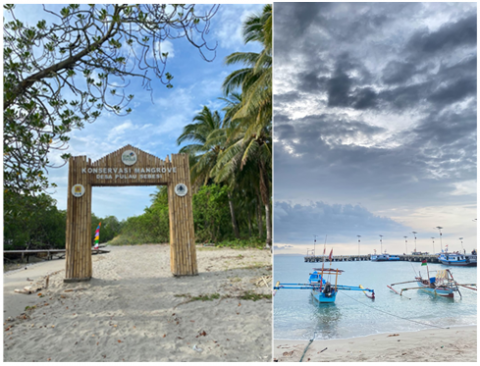
Among the islands with permanent residents is Sebesi Island [4, 5]. The island has become a popular tourist destination in Lampung Province, renowned for its exceptional natural beauty, including stunning beaches and hills reaching 844 meters above sea level, which are often used as recreational sites (Figure 1). Geographically, Sebesi Island is unique as it is the nearest island—located just 19.1 km—from the still-active Anak Krakatau Volcano.
Figure 1. Sebesi Island beach
Anak Krakatau Volcano, part of the original Krakatau Volcano that famously erupted in 1883, re-emerged as a new volcanic island known as Anak Krakatau. In 2018, the Sunda Strait saw an eruption that caused a tsunami [6-9]. One of the regions most badly hit by the 2018 tsunami was Sebesi Island, underscoring the island's ecological vulnerability and the necessity of improved coastal resilience. Coastal forest protection is one strategy to shield the island region from tsunamis. Among the many advantages of coastal woods are their ability to deter tsunami waves, prevent abrasion, and safeguard wildlife and plants [10]. In addition, coastal woods have a significant role in social, cultural, and economic facets of life, particularly for the local populations that surround the coast.
To support conservation efforts and sustainable management of coastal plant flora, it is critical to understand the diversity of plant species found in coastal locations [11]. The health of an ecosystem can be affected by the species' degree of diversity, whether it is high or low in coastal areas [12]. According to the findings of local interviews, the majority of the plant species found in Sebesi Island's coastal woods are naturally occurring, however, some are community-planted. Coastal forest management can be optimised to preserve the ecosystem with the aid of species diversity [13]. Numerous studies have been conducted on the variety of plant species and vegetative structure seen in coastal forests [14-17]. However, Sebesi Island has not had a thorough post-tsunami vegetation survey, and the South Lampung Regency Government's 2002 data solely addressed mangrove ecology [18]. This study evaluates the vegetation structure and variety following the 2018 tragedy to solve the specific ecological issue of post-tsunami coastal forest degradation on Sebesi Island.
The provision of baseline biological data to direct restoration, improve coastal resilience, and lead conservation efforts for endangered island ecosystems is what gives it scientific significance. This research is anticipated to support ecological conservation and sustainable recovery efforts, especially in comparable coastal and small-island habitats, given Sebesi Island's vulnerability to frequent natural disasters.
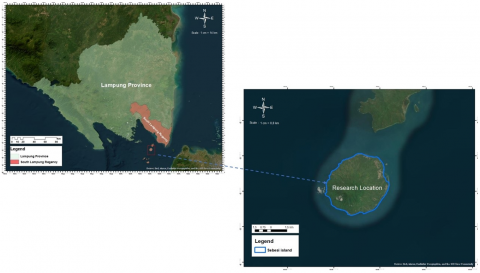
This study was carried out on Sebesi Island in Lampung Province in August and September of 2023 (Figure 2). Primary data, data derived from field measurements, was employed in this study.
2.1 Study area and sampling design
Data on the structure and diversity of coastal forest vegetation were gathered through vegetation analysis. On Sebesi Island, sampling was done along the coastline where the 2018 tsunami struck. Starting from the area nearest to the sea and moving inland, sampling plots were arranged in a systematic manner along the shoreline. Plots spanning regions with different vegetation densities and tsunami impact exposure were placed 50 meters apart. Sampling places were chosen based on three criteria: (1) closeness to the shoreline, (2) representation of both mangrove and non-mangrove vegetation types, and (3) areas with obvious indications of disturbance or regeneration.
Figure 2. Research location
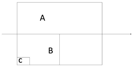
2.2 Plot sizes and vegetation classification
Different growth stages were categorised using three plot sizes:
a. 20 m × 20 m for the mature tree category
b. 10 m × 10 m for the sapling category
c. 2 m × 2 m for the seedling category were created in order to collect data (Figure 3) [19].
Figure 3. Research sample plot design
2.3 Data collection procedures
Plant height, diameter at breast height (DBH), species identification, number of individuals, and canopy cover were among the vegetation metrics that were measured. A clinometer for height estimation (for tall trees), a measuring tape for plot boundaries, a diameter tape for DBH, and a GPS unit for plot coordinate marking were among the measurement instruments.
Using field guides and references pertinent to tropical coastal vegetation, species identification was carried out.
The study area's coastal vegetation is dominated by mangrove species, hence, Cintron and Novelli's technique [20] was used to classify the different plant groups. This comprises:
·Seedlings and saplings: 4–10 cm in diameter
·Trees that are mature: diameter ≥ 10 cm
2.4 Analysis of data
Species Composition and Importance Value Index (IVI)
$Density \,\,(D)=\frac{ { Total \,\,number \,\,of \,\,individuals }}{ { Size \,\,of \,\,plots }}$
$Relative \,\,Density \,\,(R D)=\frac{ { Number \,\,of \,\,individuals \,\,of \,\,the \,\,species }}{ { Number \,\,of \,\,individuals \,\,of \,\,all \,\,species }} \times 100$
$Frequency \,\,(F)=\frac{ { Number \,\,of \,\,quadrats \,\,in \,\,which \,\,species \,\,occured }}{ { Total \,\,size \,\,of \,\,plots }}$
$Relative \,\,Frequency \,\,(R F)=\frac{{ Number \,\,of \,\,occurrence \,\,of \,\,the \,\,species }}{ { Number \,\,of \,\,occurence \,\,of \,\,all \,\,species }} \times 100$
$Relative \,\,Dominance \,\,(R D m)=\frac{{ Total \,\, basal \,\, area\,\, of \,\,the \,\,species }}{ { Total\,\, basal \,\,area \,\,of \,\,all \,\,species }} \times 100$
$Dominance \,\, (D m)=\frac{ { Total \,\, basal \,\,area \,\,of \,\,the \,\,species }}{{ Total \,\, size \,\,of \,\,plots }}$
IVI of tree and pole growth level = RD + RF + RDm
IVI of sapling and seedling growth level = RD + RF
To determine the level of control of a species in the sample plot, it is calculated using the following formula:
$Interval \,\,Class\,\, (I)=\frac{{ the \,\,highest\,\, IVI \,\,Value-the \,\,IVI \,\,value \,\,at\,\, its \,\,lowest }}{3}$
Dominance classification
·High Category (Dominant), if IVI > (lowest IVI 2I)
·Medium, if IVI = (lowest IVI + I) – (lowest IVI + 2I)
·Low (Not dominant), if IVI < (lowest IVI + I)
Vegetation Structure Analysis
Determine Vertical and Horizontal stands in plant vegetation. To determine the horizontal structure by determining canopy stratification, using the following criteria:
·Stratum A: height ˃ 30 m
·Stratum B: 20 – 30 m
·Stratum C: 4 – 20 m
·Stratum D: 1 – 4 m
·Stratum E: ˂ 1 m
One of the most crucial elements in a forest ecosystem's survival is natural regeneration. This is also true of Sebesi Island's coastal forest ecology, which contains a variety of plant species and compositions. Natural regeneration promotes the continuation of ecosystem services, including habitat provision, coastline protection, and biodiversity maintenance, in addition to demonstrating an ecosystem's ability to rebound from shocks like tsunamis. According to the findings of studies conducted on Sebesi Island, natural regeneration is calculated using a plant species' density value at each stage of growth, as shown in Table 1.
Table 1. Sebesi Island's stand density at each growth stage
|
No. |
Local Name |
Scientific Name |
Density Per Phase (%) |
Category |
||
|
Seedling |
Pole |
Tree |
||||
|
1 |
Mangrove |
Rhizophora sp. |
23.81 |
100 |
20.83 |
Tree |
|
2 |
Sea Hibiscus |
Thespesia populnea |
0 |
0 |
25 |
Tree |
|
3 |
Casuarina |
Casuarina sp. |
0 |
0 |
16.67 |
Tree |
|
4 |
Pine |
Pinus merkusii |
0 |
0 |
4.17 |
Tree |
|
5 |
Waru |
Hibiscus tiliaceus |
0 |
0 |
33.33 |
Tree |
|
6 |
Tropical Almond |
Terminalia catappa |
0 |
0 |
12.50 |
Tree |
|
7 |
Indian Beech |
Pongamia pinnata |
0 |
0 |
4.17 |
Tree |
|
8 |
White Mangrove |
Avicennia marina |
0 |
0 |
4.17 |
Tree |
|
9 |
Purple nutsedge |
Cyperus rotundus |
33.33 |
0 |
0 |
Undergrowth |
|
10 |
Yellow Nutsedge |
Cyperus esculentus |
16.67 |
0 |
0 |
Undergrowth |
|
11 |
Kera Bengu |
Mucuna pruriens |
16.67 |
0 |
0 |
Vines |
|
12 |
Merbau Pantai |
Intsia bijuga |
16.67 |
0 |
0 |
Tree |
According to Table 1, the purple nutsedge species (Cyperus rotundus) had the highest density results on Sebesi Island during the seedling phase. This is because the plant grows quickly and can also survive on disturbed soil [21]. Mangrove species exhibit the second-highest density value. Although they are frequently found on Sebesi Island, mangrove plants are only present in specific locations; not all of the island's beaches are covered in them. Since the community plants a number of different plant species, the hibiscus species had the highest density value in the adult phase (Figure 4). Aside from that, this species is found natively around the Asian shore. There are plants of this kind that can withstand severe salinity [22-24]. The most prevalent plant category in Sebesi is the tree category, or Waru plants. Sebesi Island is home to twelve different kinds of flora. Other varieties, like coconut plants, are found on Sebesi Island, according to field observations; however, the area is not close to the shore or the ocean. Nine plant species fall within the tree category out of the twelve planting kinds. This is consistent with studies by Klinka et al. [25] and Saha et al. [26] that show tree species are resistant to drought in addition to high water salinity.
High-density mangrove species, notably Rhizophora sp., are present during all growth stages, which is indicative of their vital ecological role in disaster recovery, especially in the wake of the 2018 tsunami. It has been demonstrated that mangroves serve as bio-shields that absorb wave energy, stop coastal erosion, and promote sediment deposition. Their dominance in Sebesi suggests that the restoration of natural coastal defence is on the rise. On Sebesi Island, mangrove plants have the highest density across all phases. Propagules floating in the sea are a useful method of regenerating new plants, and mangrove plants are more tolerant of maritime conditions [27, 28]. Compared to other plant species, mangrove plants produce new generations more quickly for this reason.
The growth of natural vegetation in a region is supported by the interactions between ecosystem components, which have a significant impact on the structure and composition of vegetation in that area [29]. The dynamics of a complex ecosystem are reflected in this relationship, with the environment, soil, and climate all playing a role in determining whether vegetation exists. One metric used to assess a species' degree of control or dominance in a given ecosystem is the IVI. IVI determines each species' proportional contribution at different stages of growth. IVI is a crucial metric for assessing species dominance in a measurement plot as a result. Table 2 shows the vegetation mix and degree of control of each species discovered in Sebesi Island's measurement plots.
Figure 4. Waru on the coast of Sebesi Island
Table 2. Composition and level of species control on Sebesi Island
|
No. |
Local Name |
Nama Ilmiah |
IVI Per Phase |
Mastery Level |
||
|
Seedling |
Pole |
Tree |
||||
|
1 |
Mangrove |
Rhizophora sp. |
40.48 |
300 |
47.58 |
High |
|
2 |
Sea Hibiscus |
Thespesia populnea |
- |
- |
72.19 |
Low |
|
3 |
Casuarina |
Casuarina sp. |
- |
- |
45.75 |
Low |
|
4 |
Pine |
Pinus merkusii |
- |
- |
17.97 |
Low |
|
5 |
Waru |
Hibiscus tiliaceus |
- |
- |
93.91 |
Low |
|
6 |
Tropical Almond |
Terminalia catappa |
- |
- |
32.98 |
Low |
|
7 |
Indian Beech |
Pongamia pinnata |
- |
- |
18.68 |
Low |
|
8 |
White Mangrove |
Avicennia marina |
- |
- |
18.58 |
Low |
|
9 |
Purple nutsedge |
Cyperus rotundus |
66.67 |
- |
- |
Low |
|
10 |
Yellow Nutsedge |
Cyperus esculentus |
26.19 |
- |
- |
Low |
|
11 |
Kera Bengu |
Mucuna pruriens |
26.19 |
- |
- |
Low |
|
12 |
Merbau Pantai |
Intsia bijuga |
40.48 |
- |
- |
Low |
With an IVI of 300 at the pole phase and 47.58 at the mature phase, Rhizophora sp. (mangrove) exhibits a high degree of expertise (Table 2). This demonstrates that Sebesi Island's coastal region is dominated by mangroves. According to a number of studies, mangrove trees offer significant ecological advantages, including preventing beach erosion and serving as habitat for marine biota [30, 31]. According to study findings, the majority of tree-level species, including sea hibiscus, casuarina, and waru plants, still possess a low degree of competence. Despite this, the IVI for this plant is rather high—72.19 for Sea Waru, 45.75 for Pine plants, and 93.91 for Waru plants. This is because Sebesi Island's coastline still has a very small number of individual plants. During the seedling stage, purple nutsedge and Kera Bengu plants predominate. In the meantime, IVI is in phase seedlings, specifically Kera Bengu (26.19), yellow nutsedge (26.19), and purple nutsedge (66.67). Due to its rapid growth and ability to adapt to sandy soil and open terrain, dominance in the seedling phase has great regeneration capacity [32-34]. The only time beach Merbau plants are seen on the beach is during the seedling stage. This is because adult Merbau plants on Sebesi Island grow naturally, but their growing place is still distant from the beach.
According to these results, mangrove species' dominance in both regeneration and mature stages validates their long-term importance in ecological stability, even though pioneer species and undergrowth vegetation like nutsedge considerably contribute to regeneration in the early post-disturbance phases. Similar patterns of mangrove reestablishment being essential for natural defence and biodiversity continuity are seen on Sebesi Island when compared to comparable post-tsunami vegetation studies in Aceh and Sri Lanka [35, 36]. Nonetheless, Sebesi's unique blend of tropical hardwoods and undergrowth plants provides information on successional stages unique to the area.
In attempts to conserve and maintain coastal vegetation, INP and the degree of species control are crucial. Mangrove plants are the dominant species of Sebesi Island. Dominance is still low for other types, though. However, some species are not very dominant. By comparing the number of distinct species present in the measurement plot with the tree diameter classes, the horizontal stand structure was examined. The purpose of this investigation is to comprehend Sebesi Island's tree size distribution and vegetation regeneration trends. Figure 5 displays the findings of the study on horizontal stand structure.
Figure 5. Sebesi Island's horizontal stand structure for tree classifications
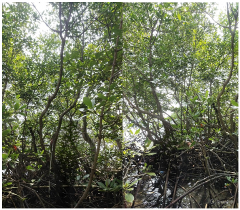
Figure 6. Sebesi Island mangrove (Rhizophora sp.) plants
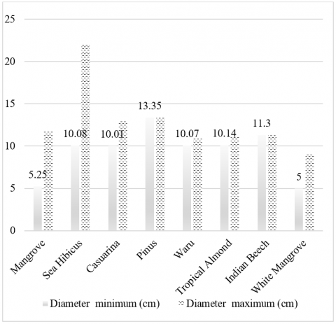
Only plants that fit into the mature and pole/stake categories have their diameters calculated, as illustrated in Figure 5, while Figure 6 shows the diversity of mangrove flora on Sebesi Island. The extent of mangrove vegetation has increased significantly due to the species’ adaptability to the island’s coastal conditions. In contrast, pine species are relatively scarce on Sebesi Island, as they are planted by local residents and do not occur naturally.
When compared to other plants, the Sea Hibiscus has the largest plant diameter. The diameter of adult Waru plants ranges from 10.08 cm at the minimum to 22.05 cm at the highest. Although the sea hibiscus plant is a plant that can adapt to the maritime environment, it can grow unevenly in less fertile soil types, which means that the Sea Hibiscus plant's diameter growth is not proportionate to its height.
Sebesi Island is home to a variety of naturally occurring plant species, including mangrove, sea hibiscus, casuarina, Waru, tropical almond, Indian beech, white mangrove, and Merbau Pantai. This is also consistent with studies by Ratnasooriya et al. [37] and Syafitri et al. [38] that found native species, including Waru, Sea Hibiscus, and tropical almond plants in the vicinity.
By comparing the number of individuals of each species with their stratum class in the measurement plot, the vertical stand structure was examined. Table 3 displays the findings of the vertical stand structure investigation conducted on Sebesi Island.
Table 3. Sebesi Island's vertical stand structure
|
No. |
Stratum |
Height (m) |
Constituent Species |
|
1 |
A |
30-40 |
- |
|
2 |
B |
20-30 |
- |
|
3 |
C |
4-20 |
Mangrove (Rhizophora sp.), Waru Laut (Thespesia populnea), Casuarina (Casuarina sp.), Pine (Pinus merkusii), Waru (Hibiscus tiliaceus), Tropical Almond (Terminalia catappa), Indian Beech (Pongamia pinnata), white mangrove (Avicennia marina) |
|
|
|
|
|
|
4 |
D |
1-4 |
Mangrove (Rhizophora sp.) and Merbau Pantai (Intsia bijuga) |
|
5 |
E |
0,4-1 |
Mangrove (Rhizophora sp.) and Intsia bijuga |
Table 3 presents the results of the research conducted on Sebesi Island. The highest number of species was recorded in stratum C, with a total of eight species. Strata D and E each contained two species.
This implies that, as is common with regrowing coastal forests, mid-level canopy species currently dominate the structure of coastal forests on Sebesi Island. In order to maintain continuity into higher strata, species that are found in Strata D and E (lower strata), such as seedlings and undergrowth, must be safeguarded because they are essential to the regeneration cycle. Their scarcity suggests that early regeneration is still limited, most likely as a result of post-tsunami disruptions.
In stratum B, there are the most species, which shows that the species on Sebesi Island are dominated by medium and small-sized species. The variety of strata on Sebesi Island indicates that the vertical stand structure is quite complex, with quite varied stratum arrangements. Regions have varying strata, indicating that the ecosystem functions are working optimally in the region [39]. The variety of stand strata produced is sufficient to create shade and maintain ecosystem function. Structural models that make up the stratum and light absorption models are carried out to aggregate the physiological processes of the entire canopy [40].
Strata D and E have fewer species than stratum B, indicating that there is still low species diversity in the lower plants. Regeneration from the lowest layer is essential for long-term forest recovery and resistance against future disturbances like storm surges or tsunamis, making this a significant ecological note. To improve resilience and ecosystem services, more proactive conservation measures are advised, such as protecting juvenile plants and planting enrichment plants.
After the 2018 tsunami, this study found that twelve plant species were flourishing along the coast of Sebesi Island. The Cyperus rotundus seedling phase (66.67 ind/ha), Rhizophora sp. pole phase, and Hibiscus tiliaceus mature tree phase all had the highest plant densities. Rhizophora sp.'s ecological significance in the coastal forest environment was highlighted by its dominance during all growth stages. Stratum C is the most developed of the three layers (C, D, and E) that make up the vertical stand structure. The low number of species found in the lower strata suggests that regeneration is continuing, but not at its best just yet.
These results highlight how crucial coastal vegetation, especially mangroves, is to bolstering ecosystem resilience and promoting ecological recovery after disasters. Planning for catastrophe risk reduction, restoration initiatives, and conservation measures can all benefit from the baseline data provided by the composition and structural complexity described in this paper. The significance of preserving and safeguarding coastal forest ecosystems in post-tsunami landscapes is further supported by the ongoing regeneration of native vegetation, which serves as a natural buffer against coastal dangers.
[1] Huchon, P., Le Pichon, X. (1984). Sunda strait and central Sumatra fault. Geology, 12(11): 668-672. https://doi.org/10.1130/0091-7613(1984)12%3C668:SSACSF%3E2.0.CO;2
[2] Harianto, S.P., Tsani, M.K., Arioen, R., Zuhelmi, T.P., Surnayanti. (2023). Perceptions of marine tourism in Lampung Bay's small islands: A comparative study. International Journal of Design and Nature and Ecodynamics, 18(5): 1261-1271. https://doi.org/10.18280/ijdne.180529
[3] Alviandy, A. (2018). 375_Pengembangan Wisata Bahari di Pesisir Pantai Teluk Lampung.pdf. https://www.academia.edu/37932469/375_Pengembangan_Wisata_Bahari_di_Pesisir_Pantai_Teluk_Lampung_pdf.
[4] Sihotang, V.B.L., Semedi, P., Triratnawati, A. (2021). The role of forest in the knowledge production of traditional medication in Tejang Village Sebesi Island, South Lampung. IOP Conference Series: Earth and Environmental Science, 917(1): 012023. https://doi.org/10.1088/1755-1315/917/1/012023
[5] Yulianto, Y., Meilinda, S.D., Fahmi, T., Hidayati, D.A., Inayah, A. (2022). Penerapan community based tourism (Cbt) Di Desa Merak Belantung Kabupaten Lampung Selatan Dalam Mewujudkan Desa Ekowisata. Jurnal Abdi Insani, 9(1): 9-19. https://doi.org/10.29303/abdiinsani.v9i1.469
[6] Muhari, A., Heidarzadeh, M., Susmoro, H., Nugroho, H. D., Kriswati, E., Supartoyo, Wijanarto, A.B., Imamura, F., Arikawa, T. (2019). The December 2018 Anak Krakatau volcano tsunami as inferred from post-tsunami field surveys and spectral analysis. Pure and Applied Geophysics, 176(12): 5219-5233. https://doi.org/10.1007/s00024-019-02358-2
[7] Walter, T. R., Haghshenas Haghighi, M., Schneider, F. M., Coppola, D., Motagh, M., Saul, J., Babeyko, A., Dahm, T., Troll, V.R., Tilmann, F., Heimann, S., Valade, S., Triyono, R., Khomarudin, R., Kartadinata, N., Laiolo, M., Massimetti, F., Gaebler, P. (2019). Complex hazard cascade culminating in the Anak Krakatau sector collapse. Nature Communications, 10(1): 4339. https://doi.org/10.1038/s41467-019-12284-5
[8] Riskianingrum, D., Tangkilisan, Y.B., Yogaswara, H., Kanumoyoso, B. (2022). The recalled of disaster memory on Sebesi Island: A historical perspective. In Proceedings of the 1st International Conference on Emerging Issues in Humanity Studies and Social Sciences (ICE-HUMS 2021), Bandung, Indonesia, pp. 607-619. https://doi.org/10.5220/0010755900003112
[9] Riskianingrum, D., Yogaswara, H. (2022). The fading of disaster memory in Pulau Sebesi: A historical construction. E3S Web of Conferences, 340: 05008. https://doi.org/10.1051/e3sconf/202234005008
[10] Irtem, E., Gedik, N., Kabdasli, M.S., Yasa, N.E. (2009). Coastal forest effects on tsunami run-up heights. Ocean Engineering, 36(3-4): 313-320. https://doi.org/10.1016/j.oceaneng.2008.11.007
[11] Loehle, C., Wigley, T.B., Schilling, E., Tatum, V., Beebe, J., Vance, E., Van Deusen, P., Weatherford, P. (2009). Achieving conservation goals in managed forests of the Southeastern Coastal Plain. Environmental Management, 44(6): 1136-1148. https://doi.org/10.1007/s00267-009-9389-2
[12] Acosta, A., Carranza, M.L., Izzi, C.F. (2009). Are there habitats that contribute best to plant species diversity in coastal dunes? Biodiversity and Conservation, 18: 1087-1098. https://doi.org/10.1007/s10531-008-9454-9
[13] Sperandii, M.G., Bazzichetto, M., Acosta, A.T.R., Barták, V., Malavasi, M. (2019). Multiple drivers of plant diversity in coastal dunes: A Mediterranean experience. Science of the Total Environment, 652: 1435-1444. https://doi.org/10.1016/j.scitotenv.2018.10.299
[14] Nugroho, Y., Suyanto, S., Makinudin, D., Aditia, S., Yulimasita, D.D., Afandi, A.Y., Harahap, M.A., Matatula, J., Wirabuana, P.Y.A.P. (2022). Vegetation diversity, structure and composition of three forest ecosystems in Angsana coastal area, South Kalimantan, Indonesia. Biodiversitas Journal of Biological Diversity, 23(5): 2640–2647. https://doi.org/10.13057/biodiv/d230547
[15] Fickert, T., Grüninger, F. (2010). Floristic zonation, vegetation structure, and plant diversity patterns within a Caribbean mangrove and swamp forest on the Bay Island of Utila (Honduras). Ecotropica, 16(2): 73-92.
[16] Burley, S.T., Harper, K.A., Lundholm, J.T. (2010). Vegetation composition, structure and soil properties across coastal forest–barren ecotones. Plant Ecology, 211: 279-296. https://doi.org/10.1007/s11258-010-9789-7
[17] Hedman, C.W., Grace, S.L., King, S.E. (2000). Vegetation composition and structure of southern coastal plain pine forests: An ecological comparison. Forest Ecology and Management, 134(1-3): 233-247. https://doi.org/10.1016/S0378-1127(99)00259-5
[18] Wiryawan, B., Bengen, D.G., Yulianto, I., Susanto, H.A., Mahi, A.K., Ahmad, M. (2002). Profil sumberdaya pulau Sebesi, kecamatan Rajabasa kabupaten Lampung selatan. Penerbitan Khusus Proyek Pesisir, Coastal Resources Center - University of Rhode Island. https://www.crc.uri.edu/download/Profil_Sumberdaya_Pulau_Sebesi.pdf.
[19] Indriyanto, I. (2024). Pengantar Budi Daya Hutan. Bumi Aksara.
[20] Vo, Q.T., Kuenzer, C., Vo, Q.M., Moder, F., Oppelt, N. (2012). Review of valuation methods for mangrove ecosystem services. Ecological Indicators, 23: 431-446. https://doi.org/10.1016/j.ecolind.2012.04.022
[21] Hou, Y., Liu, X., Zhang, X., Hu, X., Cao, L. (2016). Rhizosphere phytoremediation with Cyperus rotundus for diesel-contaminated wetlands. Water, Air, & Soil Pollution, 227: 1-8. https://doi.org/10.1007/s11270-015-2728-4
[22] Elevitch, C.R., Thomson, L.A. (2006). Hibiscus tiliaceus (beach hibiscus). Species Profiles for Pacific Island Agroforestry, 1.2: 1-14.
[23] Santiago, L.S., Lau, T.S., Melcher, P.J., Steele, O.C., Goldstein, G. (2000). Morphological and physiological responses of Hawaiian Hibiscus tiliaceus populations to light and salinity. International Journal of Plant Sciences, 161(1): 99-106. https://doi.org/10.1086/314236
[24] Wong, S.K., Lim, Y.Y., Chan, E.W.C. (2009). Antioxidant properties of Hibiscus: Species variation, altitudinal change, coastal influence and floral colour change. Journal of Tropical Forest Science, 21(4): 307-315. https://www.jstor.org/stable/23616755.
[25] Klinka, K., Qian, H., Pojar, J., Del Meidinger, V. (1996). Classification of natural forest communities of coastal British Columbia, Canada. Vegetatio, 125: 149-168. https://doi.org/10.1007/BF00044648
[26] Saha, A.K., Saha, S., Sadle, J., Jiang, J., Ross, M.S., Price, R.M., Sternberg, L.S.L.O., Wendelberger, K.S. (2011). Sea level rise and South Florida coastal forests. Climatic Change, 107: 81-108. https://doi.org/10.1007/s10584-011-0082-0
[27] Othman, M.A. (1994). Value of mangroves in coastal protection. Hydrobiologia, 285: 277-282. https://doi.org/10.1007/BF00005674
[28] Dangremond, E.M., Feller, I.C., Sousa, W.P. (2015). Environmental tolerances of rare and common mangroves along light and salinity gradients. Oecologia, 179: 1187-1198. https://doi.org/10.1007/s00442-015-3408-1.
[29] Rempas, R.D., Pasambuna, H. (2023). Vegetation potential analysis in lake Mooat Tourist Area, North Sulawesi. Journal of Tourism Economics and Policy, 3(2): 132-136. https://doi.org/10.38142/jtep.v3i2.618
[30] Gurjar, U.R., Takar, S., Bunkar, K., Pathak, V., Singh, J. (2019). Present status on distribution, biodiversity and management of Indian mangroves. Research Biotica, 1(1): 16-22. https://doi.org/10.54083/resbio.1.1.2019.16-22
[31] Su, J., Friess, D.A., Gasparatos, A. (2021). A meta-analysis of the ecological and economic outcomes of mangrove restoration. Nature communications, 12(1): 5050. https://doi.org/10.1038/s41467-021-25349-1
[32] Taheri, Y., Herrera-Bravo, J., Huala, L., Salazar, L.A., et al. (2021). Cyperus spp.: A review on phytochemical composition, biological activity, and health-promoting effects. Oxidative Medicine and Cellular Longevity, 2021(1): 4014867. https://doi.org/10.1155/2021/4014867
[33] Koné, B., Touré, A., Amadji, G.L., Yao-Kouamé, A., Angui, P.T., Huat, J. (2013). Soil characteristics and Cyperus spp. occurrence along a toposequence. African Journal of Ecology, 51(3): 402-408. https://doi.org/10.1111/aje.12050
[34] Kaizzi, C.K., Ssali, H., Vlek, P.L. (2004). The potential of Velvet bean (Mucuna pruriens) and N fertilizers in maize production on contrasting soils and agro-ecological zones of East Uganda. Nutrient Cycling in Agroecosystems, 68: 59-72. https://doi.org/10.1023/b:fres.0000012233.27360.60
[35] Wong, P.P. (2009). Impacts and recovery from a large tsunami: Coasts of Aceh. Polish Journal of Environmental Studies, 18(1): 5-16.
[36] Mattsson, E., Ostwald, M., Nissanka, S.P., Holmer, B., Palm, M. (2009). Recovery and protection of coastal ecosystems after tsunami event and potential for participatory forestry CDM–Examples from Sri Lanka. Ocean & Coastal Management, 52(1): 1-9. https://doi.org/10.1016/j.ocecoaman.2008.09.007
[37] Ratnasooriya, H.A.R., Samarawickrama, S.P., Imamura, F. (2007). Post tsunami recovery process in Sri Lanka. Journal of Natural Disaster Science, 29(1): 21-28. https://doi.org/10.2328/jnds.29.21
[38] Syafitri, D., Indriyanto, I., Setiawan, A.S.A. (2019). Populasi Tumbuhan Penyusun Hutan Pantai di Pantai Pulau Condong Lampung Selatan. Jurnal Hutan Tropis, 7(3): 302-309. https://ppjp.ulm.ac.id/journal/index.php/jht/article/view/7584.
[39] Rakocevic, M., dos Santos Scholz, M.B., Pazianotto, R.A.A., Matsunaga, F.T., Ramalho, J.C. (2023). Variation in yield, berry distribution and chemical attributes of coffea arabica beans among the canopy strata of four genotypes cultivated under contrasted water regimes. Horticulturae, 9(2): 215. https://doi.org/10.3390/horticulturae9020215
[40] Parker, G.G. (2020). Tamm review: Leaf Area Index (LAI) is both a determinant and a consequence of important processes in vegetation canopies. Forest Ecology and Management, 477: 118496. https://doi.org/10.1016/j.foreco.2020.118496