Alex J. Vergara![]() | Valeria S. Valqui-Reina
| Valeria S. Valqui-Reina![]() | Dennis Cieza-Tarrillo
| Dennis Cieza-Tarrillo![]() | Lucas D. Munoz-Astecker
| Lucas D. Munoz-Astecker![]() | Candy Lisbeth Ocaña*
| Candy Lisbeth Ocaña*![]() | Jefferson Cubas
| Jefferson Cubas![]() | Erick A. Auquiñivin-Silva
| Erick A. Auquiñivin-Silva![]()
© 2024 The authors. This article is published by IIETA and is licensed under the CC BY 4.0 license (http://creativecommons.org/licenses/by/4.0/).
OPEN ACCESS
In recent decades, the occurrence of forest fires has increased, causing damage to wild flora and fauna. For this reason, it is necessary to determine the areas susceptible to the occurrence of this phenomenon and thus implement policies for its management. In this study, the AHP and GIS method were used to map areas susceptible to forest fires in the province of Rodríguez de Mendoza located in the southern Amazon region of Peru, using climatic variables (Temperature, Precipitation and Wind Speed), topographic (altitude, slope and aspect), socioeconomic (proximity to roads and distance to populated centers) and biological (NDVI). The results indicate that 23.65% of the area is in the high-risk class and 19.05% in the very high-risk class. These risk levels are directly related to the topographic, meteorological, social and biological variables, and could trigger large-scale fires, generating losses in biological diversity and economic losses. It is concluded that 42.70% of the study area is classified as high and very high-risk areas, which makes it necessary to take relevant measures to reduce the risk of natural disasters; Furthermore, the methodology used in this research can be used in other provinces that have similar conditions.
spatial modeling, multicriteria analysis, ecological conservation, susceptibility, forest fire risk assessment
The Food and Agriculture Organization of the United Nations (FAO) mentions that the land area with a forest component covers 4.06 billion hectares (30.06%) of the land area; however, this type of component is threatened by deforestation, forest degradation and forest fires [1].
The Food and Agriculture Organization of the United Nations (FAO) indicated that the land area with a forest component covers 4.06 billion hectares (30.06%); however, this type of component is threatened by deforestation, forest degradation and forest fires [1]. Due to their exponential increase in terms of occurrence and severity, forest fires have become a major concern for many regions [2].
Several factors are involved in the initiation and development of a forest fire, including the availability of combustible material, climatic conditions, topographic characteristics of the terrain and the ignition source [3, 4]. Forest fires can be caused in two ways, the first has to do with natural events such as volcanoes and lightning, the second has to do with anthropogenic events, as humans can trigger forest fires by negligence or carelessness and by their own will to obtain some personal benefit [5], even though forest fires are beneficial for some ecological processes in forests when forest fires are caused by humans the damage increases exponentially as they put people's lives at risk and cause economic damage through the destruction of infrastructure [6], worldwide there are alarming reports on mortality due to this event, Sinha et al. [7] indicate that in the 10 countries most affected by forest fires the number of fatalities due to forest fires between the years 1900 and 2022 amounts to 2851 people.
To minimize the ecological and economic impact of forest fires, risk areas must be identified and the necessary precautionary measures must be adopted to prevent them [8]. An accurate assessment method is risk maps prepared using data layers of risk factors for the occurrence of a forest fire [9]. By using geographic information systems (GIS) and statistical methods, it is feasible to create a spatial map that describes potential forest fire risk areas in different geographic regions [10]. Susceptibility mapping involves the analysis of a multi-temporal data set, Sivrikaya and Küçük [11] indicate that four main criteria are used to prepare them: the structure of the forest, the topography, the environment and the climate. Pragya et al. [10] chose seventeen potential indicators for the evaluation of vulnerability to forest fires, these indicators covered physiographic factors, meteorological factors and anthropogenic factors that significantly affect fire susceptibility. In a similar study, Sari [12] generated zones of susceptibility to forest fires considering environmental, forestry, topographical, economic and meteorological parameters.
The need to develop studies where it is possible to know the areas that are susceptible to the occurrence of forest fires is very important, since it makes it possible to implement appropriate policies and plans to mitigate the damage that can be generated. Thus, over time, much research has been developed with the aim of studying forest fires using techniques such as geographic information systems (GIS) and remote sensing (RS) [12-15], since they provide an advanced tool with reliable spatial results that effectively contribute to fire risk management and are presented as a solution instrument to these problems, in addition to achieving the conservation of natural resources and reducing the number of victims [14].
Traditional measurements are very useful for assessing wildfire risk; however, they are expensive, time-consuming, and inaccurate [16] In the last decade, GIS techniques have been integrated with multi-criteria analysis to provide a rapid and effective method for fire risk mapping [17], as they identify various fire risk variables, such as topography, land surface temperature, vegetation types and meteorological conditions, in addition to allowing quick, economical and precise analyzes to generate a fire risk map [9, 11, 18].
In the literature, some multi-criteria analysis methods used are analytic hierarchy process (AHP), analytic network process (ANP), artificial neural networks (ANN) and fuzzy logic [11, 19]. The analytic hierarchy process (AHP) is one of the most widely used multi-criteria analysis methods for solving spatial problems and can be used as a tool for forest fire planning [10, 16, 18].
On the other hand, when trying to solve problems involving several variables such as forest fires, it is common to use multi-criteria analysis methods such as the Hierarchical Analysis Process (AHP) [19-21]. This method was developed by Saaty (1980) and is commonly used in multicriteria decision making exercises as it is useful for determining relative weights [22], the AHP method is often used in combination with other methods such as machine learning [23]. Because GIS techniques and the AHP method present optimal results for multicriteria analysis, over the years several researchers have been integrating this methodology to map areas susceptible to the occurrence of forest fires [24, 25].
In Peru, specifically in the Amazon region, the problems generated by forest fires are similar to those in other countries, as they are caused by both natural and anthropogenic factors. In this country there are few studies to map areas susceptible to forest fires using GIS and AHP [26], other studies use GIS and the AdaBoost algorithm [27], GIS and the MaxEnt algorithm [28].
This study integrated GIS techniques and the AHP method as a multi-criteria evaluation method to map areas susceptible to forest fires in the province of Rodriguez de Mendoza in the southern Amazon region of Peru, taking into account the specialization of climatic, topographic, socioeconomic and biotic factors. Based on this, the results obtained in this research will be of great help to the competent authorities and institutions so that, based on the mapping carried out, they can apply management, contingency and mitigation plans for forest fires, which represent a social and environmental risk.
2.1 Study area
Rodríguez de Mendoza is one of the seven provinces of the Amazonas region, located in northwestern Peru. It is bordered on the north, south and east by the San Martin region and on the west by the province of Chachapoyas. It covers an area of 2359 km2, which represents approximately 20.35% of the region's territory and has 31,192 inhabitants. The study area has an altitudinal range from 1022 m to 3778 m above sea level. The climate is hot and humid, with temperatures ranging from 12℃ to 30℃ (Figure 1).
Figure 1. Location of the province of Rodriguez de Mendoza
2.2 Acquisition and editing of the database
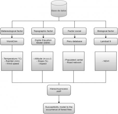
In order to build the forest fire risk model, all the factors involved in the triggering of forest fires such as anthropogenic, topographic and environmental factors must be taken into account [29, 30]; for such reason, the variables contemplated for this study were grouped into 4 factors: meteorological factor (temperature, precipitation (mm) and wind speed (m/s)), topographic factor (altitude, slope and aspect); biological factor (Normalized Difference Vegetation Index-NDVI) and the social factor (distance to roads and the distance to populated centers), all the variables contemplated contribute to the onset and spread of forest fires.
The editing and pre-processing of each of the factor variables was carried out in QGis 3.18.3 software according to the following process:
a. Meteorological factor
Meteorological variables are considered to be of great importance for the occurrence of forest fires, since they interrelate with each other easily and make the territories easy for fire initiation.
Variable 1-Temperature, Variable 2-Rainfall and Variable 3-Wind speed
The variable temperature (V1) and precipitation (V2) are important to evaluate the risk of forest fires, since in dry places and with high temperatures the combustible material is more prone to forest fires [2, 31]; on the other hand, the variable wind speed (V3) makes the fire spread more easily and intensely, making the higher the wind speed index, the more vulnerable the areas are [32]. For the elaboration of these variables, matrix images in raster format of monthly temperature and precipitation, as well as wind speed were obtained from the WorldClim database (http://www.worldclim.org) version 2.1 with a spatial resolution of 30 s (1 km²), then cut, reprojected and resampled (spatial resolution of 30 m) by "extract by mask", "reproject coordinates" and "resampling", respectively.
b. Topographic factor
Territories with higher altitudes, steep slopes and high exposure to sunlight are vulnerable to the occurrence of forest fires.
Variable 4-Altitude, Variable 5-Slope and Variable 6-Appearance
The variables of the topographic factor were generated from a Digital Elevation Model (DEM) of the SRTM (Shuttle Radar Topography Mission) radar system of 30 m spatial resolution obtained from the United States Geological Survey (USGS) website (https://earthexplorer.usgs.gov/). The variable altitude above sea level (V4) influences the occurrence of forest fires because the humidity of the site depends on it, since the higher the altitude, the higher the relative humidity, as well as the wind speed and the exposure of the land to solar radiation. The slope variable (V5) is essential to be able to model the risk for forest fire occurrence because as the slope angle increases the fire spreads faster [29, 33, 34], to obtain this variable the DEM was processed using the "slope" tool. The terrain aspect variable (V6) The indicates the risk to forest fires, since it represents the direct contact that the terrestrial surface has with the sun's rays, which facilitates the flammability of combustible material [35], as well as spaces with greater presence of high temperatures and vegetation with lower moisture content [36]. The aspect variable was obtained from DEM processing using the "aspect" tool.
c. Biological factor
Variable 7-Normalized vegetation index-NDVI
Evaluating the presence of vegetation, as well as the state of health in which it is found and how it behaves is important to determine the risk of forest fires, since it helps to interpret how the vegetation is in its entire process [1]. Therefore, NDVI takes values ranging from -1 to 1 to categorize healthy or damaged vegetation accordingly [37]. The NDVI was obtained from a Landsat 9 image, from which the NIR and RED bands were used and operationalized according to the following equation:
$N D V I=\frac{N I R-R E D}{N I R+R E D}$ (1)
where, NIR = Near infrared band and RED = Red band.
d. Social factor
Variable 8-Distance to roads
Roads are a variable because they represent a portion of bare soil, whose presence influences the risk of fire [38], and roads are also a means of contact between human activity and vegetation cover [2]. To generate the variable distance to roads, the vector database of road network of the Ministry of Transport and Communications (MTC) of Peru was used, then the "buffer" function was used, having as input the road network of the study area and an area of influence of 100 m (buffer) was established around the roads [2]; then the distance to roads was generated by applying Euclidean distance; the Euclidean distance follows the following mathematical expression:
$d_E\left(P_1, P_2\right)=\sqrt{\left(X_2-X_1\right)^2+\left(Y_2-Y_1\right)^2}$ (2)
where, dE is the Euclidean distance, P1 is the starting point, P2 is the end point and X1, X2, Y1and Y2are Cartesian coordinates.
Variable 9-Distance to population centers
Among the risks of forest fires, distance to population centers is one of the variables that influences risk due to the proximity to vegetation masses, through traditional customs that endanger forest ecosystems [38]. To generate the variable distance to populated centers, the vector database of populated centers of the National Institute of Statistics and Informatics (INEI) of Peru was used, then a buffer of 100 m was generated and then the Euclidean distance was applied to determine the distance to populated centers.
2.3 Assignment of risk classes
For the development of the model, we proceeded to classify each of the variables considered in the study as influential in the origin and spread of forest fires, making use of the "reclassify" function of Qgis, where each of the variables were classified into five risk classes Very low, Low, Medium, High and Very high [20, 39, 40], the values of each class for each variable are presented in Table 1.
Table 1. Types of irrigation applied to the study variables
|
Variables |
Class of Risk |
||||
|
Very High |
High |
Medium |
Low |
Very Low |
|
|
NDVI |
> 0.4 |
0.4 - 0.20 |
0.19 - 0.1 |
0.09 - 0.01 |
< 0.01 |
|
Distance to roads |
< 150 |
150 - 300 |
300 - 450 |
450 - 600 |
> 600 |
|
Distance to populated centers |
< 150 |
151 - 300 |
301 - 450 |
451 - 600 |
> 600 |
|
Altitude |
< 1000 |
1000 - 2000 |
2000 - 3000 |
3000 - 4000 |
> 4000 |
|
Slope |
> 50 |
30 - 50 |
20 - 30 |
10 - 20° |
10 |
|
Aspect |
North |
Northeast and Northwest |
Easth y West |
Southeasth and Southwest |
Flat and south |
|
Temperature |
> 29.4 |
23.9 - 29.4 |
18.4 - 23.9 |
12.9 - 18.4 |
< 12.9 |
|
Precipitation |
< 1000 |
1000 - 1100 |
1100 - 1200 |
1200 - 1300 |
> 1300 |
|
Wind speed |
> 4.10 |
4.10 - 3.30 |
3.30 - 2.55 |
2.55 - 1.60 |
< 1.60 |
2.4 Application of the AHP method
This is a method used for decision making based on multicriteria in a rationed and informed way, which makes it has been used in various studies of multicriteria analysis worldwide [41, 42]; this model, is based on evaluation, ranking, and synthesis [39], by means of AHP a hierarchy is established to analyze the problem and the relative priorities of each criterion are ranked using a numerical scale ranging from 1 to 9 (Table 2).
Table 2. Numerical scale for AHP
|
Intensity of Importance |
Definition |
|
1 |
Equal importance |
|
3 |
Weak importance over another |
|
5 |
Strong importance |
|
7 |
Demonstrated strong importance |
|
9 |
Absolute importance |
|
2, 4, 6, 8 |
Intermediate values between the judgments |
Table 3. Pair comparison matrix
|
Factors |
V1 |
V2 |
V3 |
V4 |
V5 |
V6 |
V7 |
V8 |
V9 |
|
NDVI |
1 |
5.00 |
3.00 |
7.00 |
9.00 |
2.00 |
4.00 |
3.00 |
2.00 |
|
Wind Speed |
0.20 |
1 |
0.50 |
3.00 |
5.00 |
0.33 |
2.00 |
1.00 |
0.50 |
|
Slope |
0.33 |
2.00 |
1 |
4.00 |
6.00 |
0.50 |
3.00 |
2.00 |
1.00 |
|
Temperature |
0.14 |
0.33 |
0.25 |
1 |
3.00 |
0.20 |
0.50 |
0.33 |
0.25 |
|
Precipitation |
0.11 |
0.20 |
0.17 |
0.33 |
1 |
0.14 |
0.25 |
0.20 |
0.17 |
|
Aspect |
0.50 |
3.00 |
2.00 |
5.00 |
7.00 |
1 |
3.00 |
2.00 |
1.00 |
|
Elevation |
0.25 |
0.50 |
0.33 |
2.00 |
4.00 |
0.33 |
1 |
0.50 |
0.33 |
|
Distance to Roads |
0.33 |
1.00 |
0.50 |
3.00 |
5.00 |
0.50 |
2.00 |
1 |
0.50 |
|
Distance to Populated Centers |
0.50 |
2.00 |
1.00 |
4.00 |
6.00 |
1.00 |
3.00 |
2.00 |
1 |
|
Sum |
3.37 |
15.03 |
8.75 |
29.33 |
46.00 |
6.01 |
18.75 |
12.03 |
6.75 |
Table 4. Random inconsistency index (RI)
|
Variables |
3 |
4 |
5 |
6 |
7 |
8 |
9 |
10 |
|
Inconsistency Random |
0.58 |
0.90 |
1.12 |
1.24 |
1.32 |
1.41 |
1.45 |
1.49 |
Table 5. Normalized AHP pairwise comparison matrix
|
Factors |
NDVI |
WS |
SL |
TM |
RF |
AS |
EI |
DR |
DS |
Weight |
|
NDVI |
0.30 |
0.33 |
0.34 |
0.24 |
0.20 |
0.33 |
0.21 |
0.25 |
0.30 |
0.28 |
|
Wind Speed (WS) |
0.06 |
0.07 |
0.06 |
0.10 |
0.11 |
0.06 |
0.11 |
0.08 |
0.07 |
0.08 |
|
Slope (SL) |
0.10 |
0.13 |
0.11 |
0.14 |
0.13 |
0.08 |
0.16 |
0.17 |
0.15 |
0.13 |
|
Temperature (TM) |
0.04 |
0.02 |
0.03 |
0.03 |
0.07 |
0.03 |
0.03 |
0.03 |
0.04 |
0.04 |
|
Precipitation (RF) |
0.03 |
0.01 |
0.02 |
0.01 |
0.02 |
0.02 |
0.01 |
0.02 |
0.02 |
0.02 |
|
Aspect (AS) |
0.15 |
0.20 |
0.23 |
0.17 |
0.15 |
0.17 |
0.16 |
0.17 |
0.15 |
0.17 |
|
Elevation (EI) |
0.07 |
0.03 |
0.04 |
0.07 |
0.09 |
0.06 |
0.05 |
0.04 |
0.05 |
0.06 |
|
Distance to Roads (DR) |
0.10 |
0.07 |
0.06 |
0.10 |
0.11 |
0.08 |
0.11 |
0.08 |
0.07 |
0.09 |
|
Distance to Populated Centers (DS) |
0.15 |
0.13 |
0.11 |
0.14 |
0.13 |
0.17 |
0.16 |
0.17 |
0.15 |
0.14 |
|
$\lambda$máx |
9.23 |
|||||||||
|
N |
9 |
|||||||||
|
CI |
0.029 |
|||||||||
|
IR |
1.45 |
|||||||||
|
CR |
0.02 |
In the process of developing the wildfire risk model, the analytic hierarchy approach (AHP) was used to organize and analyze the information in a systematic and objective manner [42, 43]. This method provides a structured framework for decomposing the problem into more manageable parts and assessing the relative importance of variables involved in wildfire occurrence [44]. To perform the pairwise comparison between the variables used in the model, a 9×9 matrix was constructed (Table 3), where each pair of variables was evaluated according to their relative importance in the occurrence of forest fires.
After the pairwise comparison (Table 3), the normalized matrix was calculated (Table 4), which represents the relative importance of each variable in relation to the others. Once the normalized matrix was obtained, the weights of the variables were calculated (Table 5). This was done by taking the average of each row of the normalized matrix, which reflects the importance of each variable in the problem to be developed.
To evaluate the consistency of the process and the reliability of the results, the consistency ratio (CR) was used [45], this relationship compares the Consistency Index (CI) obtained from the pairwise comparison matrix with an appropriate Random Coherence Index (RI) value [46]. This IR provides a reference point to determine whether the comparisons made are consistent and reliable [47].
$C I=\frac{\lambda_{m a ́ x}-n}{n-1}$ (3)
where, n is the number of criteria or factors, and $\lambda$máx is the maximum eigenvalue.
$C R=\frac{C I}{R I}$ (4)
2.5 Wildfire risk classes
There are some methods for classifying data equal interval, quantiles, natural jumps (jenks) and standard deviation in the GIS environment. In this research, once the model of areas susceptible to forest fires was generated, they were classified into five classes: very high, high, moderate, low and very low, using the Jenks Natural Breacks classification [46-48], which is a data categorization methodology that aims to maximize the organization of a given set of values into distinct and meaningful classes [49], this equal interval classification system divides the total range of characteristics from maximum to minimum into equal subranges. This creates an easy-to-understand legend and works best with continuous distribution data [50], so it is commonly used to classify forest fire maps [51-53], especially when there is an absence of threshold values in the methodology, such as the case of risk areas for the occurrence of forest fires applying AHP (Figure 2).
2.6 Model validation
The validation of the forest fire risk model obtained was verified by superimposing MODIS satellite fire points from 2010 to 2022 obtained from the portal of the National Institute of Space Research (INPE). For this, the frequency of fire hot spots and the amount of area they occupy were quantified. To analyze the possible differences between the observed and expected frequencies in the number of hot spots and the percentage of area corresponding to each fire risk class, the non-parametric chi-square (X2) hypothesis test was used [54, 55]. Additionally, the chi-square test will determine the association between the frequency of hotspots and the susceptibility of the classified areas (Very High, High, Moderate, Low and Very Low).
Figure 2. Methodological flowchart
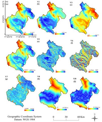
3.1 Representative variables for the occurrence of wildfires
The representative variables for the occurrence of forest fires in Rodriguez de Mendoza are shown in Figure 3. The meteorological factors are represented by the variables Temperature, Precipitation and Wind Speed (Figure 3(a), 3(b) and 3(c)), the topographic factors by the variables of altitude, slope and aspect (Figure 3(d), 3(e) and 3(f)), the biological factor is represented by the variable NDVI (Figure 3(g)), the socioeconomic factor by the variable of proximity to roads and distance to populated centers (Figure 3(h) and 3(i)).
Figure 3. Representative variables for the occurrence of forest fires in Rodríguez de Mendoza, Amazonas-Peru (a) V1-Temperature, (b) V2-Precipitation, (c) V3-Wind speed, (d) V4-Altitude, (e) V5-Slope (%), (f) V6-Terrain orientation, (g) V7-NDVI, (h) V8-Distance to roads and (i) V9-Distance to populated centers
3.2 Reclassification of representative variables for the occurrence of wildfires
Figure 4. Reclassified variables for the occurrence of forest fires in Rodríguez de Mendoza, Amazonas-Peru (a) V1-Temperature, (b) V2-Precipitation, (c) V3-Wind speed, (d) V4-Altitude, (e) V5-Slope (%), (f) V6-Terrain orientation, (g) V7-NDVI, (h) V8-Distance to roads and (i) V9- Distance to populated centers
Figure 4 shows the variables that make up each factor, reclassified according to the 5 risk classes (Table 1) identified for each variable.
3.3 Forest fire model with AHP
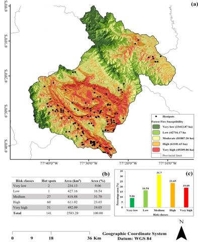
Figure 5 shows the final model of susceptible areas for the occurrence of forest fires in Rodríguez de Mendoza, Amazonas-Peru.
Figure 5. Areas at risk for the ocurrence of forest fires in Rodriguez de Mendoza, Amazonas-Peru (a) Map of forest fire risk, (b) Area of risk classes, (c) Percentage of risk classes
Table 6. Calculated area for each risk class for forest fire occurrence
|
Risk Classes |
Hot Spots |
Area (km2) |
Area (%) |
|
Very low |
2 |
234.13 |
9.06 |
|
Low |
1 |
427.16 |
16.54 |
|
Medium |
27 |
818.88 |
31.70 |
|
High |
60 |
611.02 |
23.65 |
|
Very high |
51 |
492.09 |
19.05 |
|
Total |
141 |
2583.28 |
100.00 |
Based on the results of the risk areas for the occurrence of forest fires (Figure 5 and Table 6), it can be seen that in Rodriguez de Mendoza 23.65% of the territory has a high risk level and 19.05% of the territory has a very high risk level for the occurrence of forest fires; in addition, it can be seen that the high class zone has a record of 60 hotspots and in the very high class zone there are 51 hotspots.
Modeling to determine areas susceptible to the occurrence of forest fires is complex because it integrates various factors, for this reason it is important that to determine the areas susceptible to the occurrence of forest fires by modeling in a GIS environment, the necessary geospatial data are identified and the methodology to be used is determined in study [56] order to be certain that the model generated will be efficient; in this study meteorological, biological, social and topographic variables were integrated, which are among the most used when determining areas at risk of forest fires [15, 16].
The fuel material is a determining factor for the start of a fire and the occurrence of a forest fire, since it depends on the nature of the fuel material to start and spread forest fires. For this reason, in this study we gave greater weight of importance to the NDVI variable that has the function of plant material, assigning a value of 0.28, this is consistent with the study by Zhao et al. [57], who, as in this study, gave the greatest weight of importance to the NDVI variable with 0.44, who, as in this study, gave the highest weight of importance to the NDVI variable with 0.44; on the other hand, study [58] of all the variables used in the modeling, the NDVI had a significant weight only below the topographic variables, which confirms the importance of this variable for forest fire modeling.
Forest fires are an environmental problem, Rojas Estrada et al. [59] indicate that its occurrence is related to climatic, environmental, topographic and socioeconomic variables; On the other hand, Pérez-Verdín et al. [60] suggest that they are mostly caused by human action, so factors such as accessibility, distance to roads and towns, among others, must be considered in their analysis. Anthropogenic forest fires are highly dependent on human activities and can change depending on human actions, especially the indiscriminate and inappropriate burning of grasses, weeds and stubble in rural areas of the country [61], therefore, the Susceptibility of territories to forest fires caused by natural or anthropogenic causes must be evaluated separately [62]. Topographic variables are important for the spread of forest fires, since it will depend on the topographic characteristics of the territory for forest fires to spread or stop their course; in this sense, this study considered topographic variables as the second order of hierarchical importance.
Topographic variables are important for the spread of forest fires, since it will depend on the topographic characteristics of the territory for forest fires to spread or stop their course; in this sense, this study considered topographic variables as the second order of hierarchical importance after NDVI, being the aspect and slope variables those that had the highest weight of the topographic factor with 0.17 and 0.13, respectively. The hierarchical ranking of these values is due to the fact that the aspect of the terrain has to do with the direction in which a slope faces the sun, an important factor that influences the fire behavior through the variation of solar radiation and wind action [63]; on the other hand, the slope has importance because this due to the fact that it does not directly influence the ignition of the fire, but it does influence the fire behavior [64].
Forest fires are often started by human activity [65] usually due to negligence in people's activities such as rubbing and burning of soils for the establishment of agricultural plots; given this and taking into account that the places closest to population centers are the most prone to start fires, the variable distance to population centers was given a higher score than the variable distance to the road network being 0.14 for the first mentioned variable and 0.09 for the second, this is similar to what was done by Akbulak et al. [66] who in their study indicate that areas with higher population density are more prone to wildfire occurrence.
There are different approaches regarding the role of humans in forest fires, most authors hold humans responsible for developing accidental or intentional practices [67] that trigger large-scale forest fires; on the other hand, there are authors who state that villagers can have a positive performance since in the event of a forest fire they can act as mitigators or controllers [68]; however, from our perspective it can be mentioned that it is unlikely that a group of villagers without respective training and equipment can mitigate a forest fire, if not that by exercising this type of actions they put their lives and those of their families at risk.
While it is true that topographic, social and biophysical factors are determinant in determining the occurrence of forest fires, the meteorological factor is of some importance since temperature and precipitation can create a favorable or unfavorable environment for the occurrence of forest fires and wind speed helps the fire to accelerate or stop, as it is known that temperature has a direct effect on forest fires [69], since high temperatures encourage biological material to reach the ignition point and start a fire; however, in areas with low temperatures this variable is less likely to start a fire, since high temperatures encourage biological material to reach the ignition point and start a fire; however, in areas with low temperatures the probability that this variable will start a fire is lower, for this reason in this study it was given low hierarchical importance with 0.04.
In this study, greater hierarchical importance was given to NDVI, Aspect, slope and Distance to populated centers, from which results were obtained that show that of the total area of the province of Rodríguez de Mendoza, 19.05% has a very high susceptibility level, 23.65% has high susceptibility and the average level is 31.7%, these results contrast with Kayet et al.’s study [3] who in their study give greater importance to NDVI, followed by topographic and meteorological variables, 2020) who in their study gave the greatest importance to NDVI, followed by topographic and meteorological variables, with which they obtained that most of the study area presented a medium to very high risk level, in the same way Sakellariou et al. [70] within the variables with the greatest hierarchical importance contemplated in their study were NDVI, aspect and slope of the terrain, with which they found that the study area has a greater area with a medium to very high risk level.
With the results generated in this study it is possible to determine that the main risk factor for the occurrence of forest fires is the combustible material that can be understood as vegetation and that topographic, social and meteorological factors are the ones that determine the start of the fire and its propagation, These results serve as an instrument and preventive measure against the possible occurrence of forest fires in the province of Rodriguez De Mendoza in the department of Amazonas, being elaborated by means of an analytical predictive model that allows the hierarchy of variables that function as conditioning factors for the origin, development and propagation of forest fires in the study area.
From the results obtained it can be concluded that 42.70% of the area of Rodriguez de Mendoza is classified as high and very high risk areas for the occurrence of forest fires, so it is necessary to take appropriate actions to prevent forest fires and implement policies that allow an action plan to deal with these events.
On the other hand, it can be indicated that the methodology used in this research can be applied to other provinces in the Amazon region and Peru as long as they have geographical and climatic conditions similar to those of Rodriguez de Mendoza. Applying the AHP method or other existing methodologies such as machine learning techniques, fuzzy logic, among others. Including socioeconomic and demographic variables, to obtain a result that covers the social aspects in terms of risks.
The researchers wish to express their gratitude to the project “Improvement of the undergraduate training service in university higher education of the Professional School of Forestry Engineering of the UNTRM district of Chachapoyas—Province of Chachapoyas—Department of Amazonas”, of the Peruvian Government with the number grant CUI 2513702, to the Institute of Research, Innovation and Development of the Agricultural and Agroindustrial (IIDAA), to the Laboratory of Geospatial Analysis and Forest Management of the National University of Amazonas Toribio Rodríguez de Mendoza (UNTRM) and to the Laboratory of Remote Sensing and Data Analysis (SIRANDA) of the National University of Jaén (UNJ), for the logistical and academic support for the development of this research.
[1] Abdo, H.G., Almohamad, H., Al Dughairi, A.A., Al-Mutiry, M. (2022). GIS-based frequency ratio and analytic hierarchy process for forest fire susceptibility mapping in the western region of Syria. Sustainability, 14(8): 4668. https://doi.org/10.3390/su14084668
[2] Vergara Anticona, A., Ocaña Zúñiga, C., Rosa, A, Lorenzon, A.S., Antonio, P. (2023). Gis and fuzzy logic approach for forest fire risk modeling in the Cajamarca region, Peru. Decision Science Letters, 12: 353-368. https://doi.org/10.5267/dsl.2023.1.002
[3] Kayet, N., Chakrabarty, A., Pathak, K., Sahoo, S., Dutta, T., Hatai, B.K. (2020). Comparative analysis of multi-criteria probabilistic FR and AHP models for forest fire risk (FFR) mapping in Melghat Tiger Reserve (MTR) forest. Journal of Forestry Research, 31: 565-579. https://doi.org/10.1007/s11676-018-0826-z
[4] Pourghasemi, H.R., Beheshtirad, M., Pradhan, B. (2016). A comparative assessment of prediction capabilities of modified analytical hierarchy process (M-AHP) and Mamdani fuzzy logic models using Netcad-GIS for forest fire susceptibility mapping. Geomatics, Natural Hazards and Risk; 7(2): 861-885. https://doi.org/10.1080/19475705.2014.984247
[5] Van Hoang, T., Chou, T.Y., Fang, Y.M., Nguyen, N.T., Nguyen, Q.H., Canh, P.X., Dang, N.B., Xuan, L.N., Michael, E.M. (2020). Mapping forest fire risk and development of early warning system for NW Vietnam using AHP and MCA/GIS methods. Applied Sciences, 10(12): 1-19. https://doi.org/10.3390/app10124348
[6] Gigović, L., Jakovljević, G., Sekulović, D., Regodić, M. (2018). GIS multi-criteria analysis for identifying and mapping forest fire hazard: Nevesinje, Bosnia and Herzegovina. Tehnicki Vjesnik, 25: 891-897. https://doi.org/10.17559/TV-20151230211722
[7] Sinha, A., Nikhil, S., Ajin, R.S., Danumah, J.H., Saha, S., Costache, R., Rajaneesh, A., Sajinkumar K.S., Amrutha, K., Johny, A., Marzook F., Mammen, C., Abdelrahman, K., Fnais, M., Abioui, M. (2023). Wildfire risk zone mapping in contrasting climatic conditions: An Approach employing AHP and F-AHP models. Fire, 6(44): 1-33. https://doi.org/10.3390/fire6020044
[8] Akay, A.E., Wingm M.G., Zenginm, M., Kose, O. (2017). Determination of fire-access zones along road networks in fire-sensitive forests. Journal of Forestry Research, 28: 557-564. https://doi.org/10.1007/s11676-016-0283-5
[9] Akay, A.E., Şahin, H. (2019). Forest fire risk mapping by using GIS techniques and AHP method: A case study in Bodrum (Turkey). European Journal of Forest Engineering, 5: 25-35. https://doi.org/10.33904/EJFE.579075
[10] Pragya, Kumar, M., Tiwari, A., Majid, S.I., Bhadwal, S., Sahu, N., Verma, N., Tripathi, D., Avtar, R. (2023). Integrated spatial analysis of forest fire susceptibility in the Indian Western Himalayas (IWH) using remote sensing and GIS-based fuzzy AHP approach. Remote Sens, 15(19): 4701. https://doi.org/10.3390/rs15194701
[11] Sivrikaya, F., Küçük, Ö. (2022). Modeling forest fire risk based on GIS-based analytical hierarchy process and statistical analysis in Mediterranean region. Ecological Informatics, 68: 101537. https://doi.org/10.1016/j.ecoinf.2021.101537
[12] Sari, F. (2021). Forest fire susceptibility mapping via multi-criteria decision analysis techniques for Mugla, Turkey: A comparative analysis of VIKOR and TOPSIS. Forest Ecology and Management, 480: 118644. https://doi.org/10.1016/j.foreco.2020.118644
[13] Chuvieco, E., Aguado, I., Yerba, M., Nieto, H., Martin, P., Vilar, L., Martinez, J., Padron, D., Martin, S., Salas, J. (2007) Generación de un Modelo de Peligro de Incendios Forestales mediante Teledetección y SIG. Teledetección: Hacia Un Mejor Entendimiento de La Dinámica Global y Regional, 19-26.
[14] Chuvieco, E.A., Aguado, I.A., Jurdao, S.A., Pettinari, M.L.A., Yebra, M.A., Salas, J., Hanston, S., de la Riva, J., Ibarra, P., Rodrigues, M., Echevarría, M., Azqueta, D.C., Román, M.V., Bastarrika, A., Martínez, S., Recondo, C., Zapico, E., Martínez-Vega, F.J. (2014). Integrating geospatial information into fire risk assessment. International Journal of Wildland Fire, 23: 606-619. https://doi.org/10.1071/WF12052
[15] Eugenio, F.C., Santos, A.R, Fiedler, N.C., Ribeiro, G.A., da Silva, A.G., dos Santos, Á., Paneto, G., Schettino, R. (2016). Applying GIS to develop a model for forest fire risk: A case study in Espírito Santo, Brazil. Journal of Environmental Management, 173: 65-71. https://doi.org/10.1016/j.jenvman.2016.02.021
[16] Novo, A., Fariñas-Álvarez, N., Martínez-Sánchez, J., González-Jorge, H., Fernández-Alonso, J.M., Lorenzo, H. (2020). Mapping forest fire risk—A case study in Galicia (Spain). Remote Sens, 12(22): 3705. https://doi.org/10.3390/rs12223705
[17] Çolak, E., Sunar, F. (2020). Evaluation of forest fire risk in the Mediterranean Turkish forests: A case study of Menderes region, Izmir. International Journal of Disaster Risk Reduction, 45: 101479. https://doi.org/10.1016/j.ijdrr.2020.101479
[18] Esen, F., Avci, V. (2018). Forest fire susceptibility analysis of Kahramanmaras Province. Bingöl Üniversitesi Sosyal Bilimler Enstitüsü Dergisi, 8: 335-356. https://doi.org/10.29029/busbed.437858
[19] Sari, E.N., Prueksakorn, K., Gonzalez, J.C., Arpornthip, T., Areerob, T., Pornsawang, C., Pimonsree, S. (2018). Inventory of greenhouse gas emissions for Phayao Province - An agricultural city in Thailand. Chemical Engineering Transactions, 63: 163-168. https://doi.org/10.3303/CET1863028
[20] Kumari, B., Pandey, A.C. (2020). Geo-informatics based multi-criteria decision analysis (MCDA) through analytic hierarchy process (AHP) for forest fire risk mapping in Palamau Tiger Reserve, Jharkhand state, India. Journal of Earth System Science, 129. https://doi.org/10.1007/s12040-020-01461-6
[21] Pradeep, G.S., Danumah, J.H., Nikhil, S., Prasad, M.K., Patel, N., Mammen, P.C., Rajaneesh, A., Valeria-Ersilia, O., Ajin, R.S., Kuriakose, S.L. (2022) Forest fire risk zone mapping of eravikulam national park in India: A comparison between frequency ratio and analytic hierarchy process methods. Croatian Journal of Forest Engineering, 43: 199-217. https://doi.org/10.5552/crojfe.2022.1137
[22] Thakur, A.K., Singh, D. (2014). Forest fire risk zonation using geospatial techniques and analytic hierarchy process in Dehradun District, Uttarakhand, India. Universal Journal of Environmental Research and Technology, 4(2): 82-89.
[23] Stević, Ž., Tanackov, I., Vasiljević, M., Novarlić, B., Stojić, G. (2016). An integrated fuzzy AHP and TOPSIS model for supplier evaluation. Serbian Journal of Management, 11: 15-27. https://doi.org/10.5937/sjm11-10452
[24] Busico, G., Giuditta, E., Kazakis, N., Colombani, N. (2019). A hybrid GIS and AHP approach for modelling actual and future forest fire risk under climate change accounting water resources attenuation role. Sustainability, 11(24): 7166. https://doi.org/10.3390/su11247166
[25] Çoban, H.O., Erdin, C. (2020). Forest fire risk assessment using GIS and AHP integration in bucak forest enterprise, Turkey. Applied Ecology and Environmental Research, 18(1): 1567-1583. https://doi.org/10.15666/aeer/1801_15671583
[26] Ysla Huaman, M.H., Ponce Ramos, C.J., Zacarias Arauco, N.D, Cornejo Tueros, J.V. (2023). Modeling of Risk Zones for Forest Fires in High Andean Zones of Peru. In 7th International Conference on Energy and Environmental Science, Cham, pp. 65-78.
[27] Bax, V. (2018). Mapping the risk of forest fires in Peru’s Amazon and Andean Forest regions using the AdaBoost algorithm and Geographic Information Systems. In 2018 IEEE XXV International Conference on Electronics, Electrical Engineering and Computing (INTERCON), pp. 1-4. https://doi.org/10.1109/INTERCON.2018.8526470
[28] Rojas-Briceño, N.B., Soto Carrión, C., Tuesta-Mendoza, S., Silva-López, J.O., Sáenz Pohl, G. (2023). Probabilidad de ocurrencia de incendios forestales en Apurímac. Hatun Yachay Wasi, 2: 85-97. https://doi.org/10.57107/hyw.v2i2.49
[29] Ghorbanzadeh, O., Blaschke, T., Gholamnia, K., Aryal, J. (2019). Forest fire susceptibility and risk mapping using social/infrastructural vulnerability and environmental variables. Fire, 2(3): 50. https://doi.org/10.3390/fire2030050
[30] Kim, S.J., Lim, C.H., Kim, G.S., Lee, J., Geiger, T., Rahmati, O., Son, Y., Lee, W. (2019). Multi-temporal analysis of forest fire probability using socio-economic and environmental variables. Remote Sens, 11(1): 86. https://doi.org/10.3390/rs11010086
[31] Mishra, B., Panthi, S., Poudel, S., Ghimire, B.R. (2023). Forest fire pattern and vulnerability mapping using deep learning in Nepal. Fire Ecology, 19: 3. https://doi.org/10.1186/s42408-022-00162-3
[32] Zhang, G., Wang, M., Liu, K. (2019). Forest fire susceptibility modeling using a convolutional neural network for Yunnan Province of China. International Journal of Disaster Risk Science, 10: 386-403. https://doi.org/10.1007/s13753-019-00233-1
[33] Kolden, C.A., Abatzoglou, J.T. (2018). Spatial distribution of wildfires ignited under katabatic versus non-katabatic winds in mediterranean Southern California USA. Fire, 1: 1-17. https://doi.org/10.3390/fire1020019
[34] Oulad, S.Y., Mousannif, H., Al Moatassime, H. (2019) Predictive modeling of wildfires: A new dataset and machine learning approach predictive modeling of wildfires: A new dataset approach. Fire Safety Journal, 104: 130-146. https://doi.org/10.1016/j.firesaf.2019.01.006
[35] Naderpour, M., Rizeei, H.M., Ramezani, F. (2021). Forest fire risk prediction: A spatial deep neural network-based framework. Remote Sens, 13(13): 2513. https://doi.org/10.3390/rs13132513
[36] Moayedi, H., Mehrabi, M., Bui, D.T., Pradhan, B., Foong, L.K. (2020) Fuzzy-metaheuristic ensembles for spatial assessment of forest fire susceptibility. Journal of Environmental Management, 260: 109867. https://doi.org/https://doi.org/10.1016/j.jenvman.2019.109867
[37] Atun, R., Kalkan, K., Gürsoy, Ö. (2020). Determining the forest fire risk with sentinel 2 images. Turkish Journal of Geosciences, 1(1): 22-26.
[38] López, D.C.R., Ochoa, D.C.L. (2021). Evaluación espaciotemporal de la cobertura vegetal del parque nacional Henri Pittier, Venezuela. Geofocus: Revista Internacional de Ciencia y Tecnología de la Información Geográfica, 28: 25-58.
[39] Rahmani, S., Benmassoud, H. (2019) Modelling of forest fire risk spatial distribution in the region of Aures, Algeria. Geoadria, 24. https://doi.org/10.15291/geoadria.2846
[40] Kanga, S., Tripathi, G., Singh, S.K. (2017). Forest fire hazards vulnerability and risk assessment in Bhajji forest range of Himachal Pradesh (India): A geospatial approach. Journal of Remote Sensing & GIS, 8: 1-16.
[41] Tshering, K., Thinley, P., Shafapour, Tehrany, M., Thinley, U., Shabani, F. (2020). A comparison of the qualitative analytic hierarchy process and the quantitative frequency ratio techniques in predicting forest fire-prone areas in Bhutan using GIS. Forecasting, 2: 36-58. https://doi.org/10.3390/forecast2020003
[42] Dey, B., Abir, K.A.M., Ahmed, R., Salam, M.A., Redowan, M., Miah, M.D., Iqbal, M.A. (2023). Monitoring groundwater potential dynamics of north-eastern Bengal Basin in Bangladesh using AHP-machine learning approaches. Ecological Indicators, 154: 110886. https://doi.org/10.1016/J.ECOLIND.2023.110886
[43] Sinha, A., Nikhil, S., Ajin, R.S., Danumah, J.H., Saha, S., Costache, R., Rajaneesh, A., Sajinkumar, K.S., Amrutha, K., Johny, A., Marzook, F., Mammen, P.C., Abdelrahman, K., Fnais, M.S., Abioui, M. (2023). Wildfire Risk zone mapping in contrasting climatic conditions: An approach employing AHP and F-AHP models. Fire, 6(2): 44. https://doi.org/10.3390/FIRE6020044
[44] Ju, W., Xing, Z., Wu, J., Kang, Q. (2023). Evaluation of forest fire risk based on multicriteria decision analysis techniques for Changzhou, China. International Journal of Disaster Risk Reduction, 98: 104082. https://doi.org/10.1016/J.IJDRR.2023.104082
[45] Parajuli, A, Manzoor, S.A., Lukac, M. (2023). Areas of the Terai Arc landscape in Nepal at risk of forest fire identified by fuzzy analytic hierarchy process. Environmental Development, 45: 100810. https://doi.org/10.1016/J.ENVDEV.2023.100810
[46] Unver, S., Ergenc, I. (2021). Safety risk identification and prioritize of forest logging activities using analytic hierarchy process (AHP). Alexandria Engineering Journal, 60: 1591-1599. https://doi.org/10.1016/J.AEJ.2020.11.012
[47] Ajin, R., Loghin, A.M., Vinod, P., Jacob, M. (2016). Forest fire risk zone mapping using rs and gis techniques: A study in achankovil forest division, Kerala, India. Journal of Earth, Environment and Health Sciences, 2:109. https://doi.org/10.4103/2423-7752.199288
[48] Ajin, R.S., Ciobotaru, A.M., Vinod, P.G., Jacob, M.K. (2015). Forest and wildland fire risk assessment using geoespatial techniques: A case study of Nemmara forest division, Kerala, India. Journal of Wetlands Biodiversity, 5: 29-37.
[49] Juvanhol, R.S., Fiedler, N.C., Dos Santos, A.R., Da Silva, G.F., Omena, M.S., Eugenio, F.C. Pinheiro, J.G., Filho, F.A. (2021). Gis and fuzzy logic applied to modelling forest fire risk. Anais da Academia Brasileira de Ciencias, 93(3): e20190726. https://doi.org/10.1590/0001-3765202120190726
[50] Sivrikaya, F., Günlü, A., Küçük, Ö., Ürker, O. (2024). Forest fire risk mapping with Landsat 8 OLI images: Evaluation of the potential use of vegetation indices. Ecological Informatics, 79: 102461. https://doi.org/10.1016/j.ecoinf.2024.102461
[51] Erden, T., Coşkun, M.Z. (2010). Multi-criteria site selection for fire services: The interaction with analytic hierarchy process and geographic information systems. Natural Hazards and Earth System Science, 10: 2127-2134. https://doi.org/10.5194/nhess-10-2127-2010
[52] Beverly, J.L., McLoughlin, N. (2019). Burn probability simulation and subsequent wildland fire activity in Alberta, Canada – Implications for risk assessment and strategic planning. Forest Ecology and Management, 451: 117490. https://doi.org/10.1016/j.foreco.2019.117490
[53] Nikhil, S., Danumah, J.H., Saha, S., Prasad, M.K., Rajaneesh, A., Pratheesh, C., Mammen, R., Ajin, S. (2021). Application of GIS and AHP Method in Forest Fire Risk Zone Mapping: A study of the Parambikulam Tiger Reserve, Kerala, India. Journal of Geovisualization and Spatial Analysis, 5-14. https://doi.org/10.1007/s41651-021-00082-x/Published
[54] Janiec, P., Gadal, S. (2020). A comparison of two machine learning classification methods for remote sensing predictive modeling of the forest fire in the north-eastern Siberia. Remote Sens, 12(24): 4157. https://doi.org/10.3390/rs12244157
[55] Lamat, R., Kumar, M., Kundu, A., Lal, D. (2021). Forest fire risk mapping using analytical hierarchy process (AHP) and earth observation datasets: A case study in the mountainous terrain of Northeast India. SN Applied Sciences, 3: 425. https://doi.org/10.1007/s42452-021-04391-0
[56] Sharma, L.K., Kanga, S., Nathawat, M.S., Sinha, S., Pandey, P.C. (2021). Fuzzy AHP for forest fire risk modeling. Disaster Prevention and Management, 21(2): 160-171. https://doi.org/10.1108/09653561211219964
[57] Zhao, P., Zhang, F., Lin, H., Xu, S. (2021). Gis-based forest fire risk model: A case study in Laoshan national forest park, Nanjing. Remote Sens, 13. https://doi.org/10.3390/rs13183704
[58] Novo, A., Fariñas-Álvarez, N., Martínez-Sánchez, J., González-Jorge, H., Fernández-Alonso, J.M., Lorenzo, H. (2020). Mapping forest fire risk—A case study in Galicia (Spain). Remote Sens, 12(22): 3705. https://doi.org/10.3390/rs12223705
[59] Rojas Estrada, L.I., Romo Lozano, J.L., Rodríguez Trejo, D.A., Villanueva-Morales, A. (2022). Susceptibilidad a incendios en el Campo Forestal Experimental Las Cruces, Texcoco, México: una priorización basada en el enfoque multicriterio. Sociedad y Ambiente, 1-35. https://doi.org/10.31840/sya.vi25.2484
[60] Pérez-Verdín, G.A., Márquez-Linares, M., Cortés-Ortiz, A., Salmerón-Macías, M. (2013) Análisis espacio-temporal de la ocurrencia de incendios forestales en Spatial-temporal analysis of fire occurrence in Durango, Mexico. Madera y bosques.
[61] Sari, F. (2021). Forest fire susceptibility mapping via multi-criteria decision analysis techniques for Mugla, Turkey: A comparative analysis of VIKOR and TOPSIS. Forest Ecology and Management, 480: 118644. https://doi.org/https://doi.org/10.1016/j.foreco.2020.118644
[62] Edwards, R.B., Falcon, W.P., Higgins, M.M., Naylor, R.L. (2019). Causes of Indonesia’s forest fires. World Development, 127: 104717. https://doi.org/10.1016/j.worlddev.2019.104717
[63] Enoh, M.A., Okeke, U.C., Narinua, N.Y. (2021). Identification and modelling of forest fire severity and risk zones in the Cross – Niger transition forest with remotely sensed satellite data. The Egyptian Journal of Remote Sensing and Space Science, 24: 879-887. https://doi.org/https://doi.org/10.1016/j.ejrs.2021.09.002
[64] Pandey, K., Ghosh, S.K. (2018). Modeling of parameters for forest fire risk zone mapping. International Archives of the Photogrammetry, Remote Sensing and Spatial Information Sciences - ISPRS Archives, 299-304. https://doi.org/10.5194/isprs-archives-XLII-5-299-2018
[65] Zhou, L., Liu, Y., Lu, J., Zhou, W., Wang, H. (2021) Influence of recycled concrete powder (RCP) and recycled brick powder (RBP) on the physical/mechanical properties and durability of raw soil. Coatings, 11. https://doi.org/10.3390/coatings11121475
[66] Akbulak, C., Tatlı, H., Aygün, G., Sağlam, B. (2018). Forest fire risk analysis via integration of GIS, RS and AHP: The case of Çanakkale, Turkey. Journal of Human Sciences, 15: 2127. https://doi.org/10.14687/jhs.v15i4.5491
[67] Gibson, R., Danaher, T., Hehir, W., Collins, L. (2020). A remote sensing approach to mapping fire severity in south-eastern Australia using sentinel 2 and random forest. Remote Sensing of Environment, 240: 111702.
[68] Martínez Torres, H.L., Pérez Salicrup, D.R. (2018). El papel del campesinado ante la regulación de los incendios forestales en México: Consecuencias inesperadas. Perspectivas Rurales Nueva Época, 30. https://doi.org/10.15359/prne.16-31.5
[69] Masinda, M.M., Li, F., Qi, L., Sun, L., Hu, T. (2022). Forest fire risk estimation in a typical temperate forest in Northeastern China using the Canadian forest fire weather index: Case study in autumn 2019 and 2020. Natural Hazards, 111: 1085-1101. https://doi.org/10.1007/s11069-021-05054-4
[70] Sakellariou, S., Cabral, P., Caetano, M., Pla, F., Painho, M., Christopoulou, O., Sfougaris, A., Dalezios, N., Vasilakos, C. (2020). Remotely sensed data fusion for spatiotemporal geostatistical analysis of forest fire hazard. Sensors, 20(17), 5014. https://doi.org/10.3390/s20175014