Zhanna Almanova*![]() | Sayagul Kenzhegulova
| Sayagul Kenzhegulova![]() | Askar Kashkarov
| Askar Kashkarov![]() | Gulnur Kekilbayeva
| Gulnur Kekilbayeva![]() | Erkin Ussalinov
| Erkin Ussalinov![]() | Dilmurat Yerzhan
| Dilmurat Yerzhan![]() | Aizhan Zhakenova
| Aizhan Zhakenova![]() | Grigory Zvyagin
| Grigory Zvyagin![]()
© 2023 IIETA. This article is published by IIETA and is licensed under the CC BY 4.0 license (http://creativecommons.org/licenses/by/4.0/).
OPEN ACCESS
The examination of alterations in fundamental soil properties as a consequence of long-term agricultural usage holds significant theoretical and practical implications. This research was primarily designed to analyze the agroecological transformation of zonal soil fertility attributes due to extended agricultural practices in Northern Kazakhstan. The methodological approach adopted in this study incorporated soil and landscape mapping, supplemented by Geographic Information System (GIS) interpolation techniques. The focus of the paper is on the temporal evolution of key soil components - namely humus, nitrogen, mobile phosphorus, and exchangeable potassium - over an extended period of agricultural land use within the Kostanay district, situated in the Kostanay region. The Soil Absorbing Complex (SAC) of the scrutinized soils was found to be predominantly composed of calcium (77-87%) and magnesium (11-15%). Over the course of a 33-year timeline, a slight reduction in the levels of humus, nitrogen, phosphorus, and potassium was observed. It was discerned that prolonged agricultural practices instigated minor decremental trends in crucial soil fertility parameters. In essence, the study offers valuable insights into the subtle, yet significant, impacts of long-term agricultural land use on soil fertility, contributing to our understanding of sustainable agricultural practices. This research underscores the need for careful management of agricultural lands to preserve soil health and ensure long-term productivity.
fertility, humus, labile phosphorus, nitric nitrogen, property transformation, sum of absorbed bases
The incorporation of steppe zone lands into agricultural utilization has been identified as a primary factor influencing the transformation of soil characteristics. Long-term plowing has been found to modify morphological properties, humus content, and agrochemical and physicochemical attributes of soils, thereby impacting their fertility [1, 2]. A multitude of publications has documented a decline in soil fertility concurrent with intensive agricultural usage in Kazakhstan [2-4].
Under such intensive use, soils undergo dehumification, acidification, salinization, compaction of the arable layer, de-structuring, and anthropogenic pollution. These deleterious processes are particularly pronounced in the fertile soils of the central chernozem zone, leading to a downward trend in agricultural crop productivity. The necessity to address transformations in soil formation processes and soil fertility under anthropogenic pressures stems from the pivotal roles that soil and soil cover play in the biosphere. These functions include serving as habitats and sources of matter and energy for terrestrial organisms [2, 3].
The intensification of agriculture has also been linked with fertility decline in black soils [1, 2, 4], accompanied by similar negative processes as observed in the chernozem zone [2-4]. The impact on crop productivity has been equally detrimental.
Therefore, there is an urgent need for research focusing on the development of new, efficient, and environmentally friendly technologies and techniques to protect agricultural landscapes from degradation and enhance productivity [5, 6]. Rational natural resource management requires a comprehensive understanding of the natural and ecological conditions that define the productive capacity and environmental resilience of soil cover units - soil combinations in agricultural landscapes [7, 8].
Several solutions have been proposed for optimal site selection for additional sampling, with the conventional kriging technique of geostatistics being the primary method [7]. This approach often necessitates prior knowledge of the correlation function (or variogram) of the targeted property. Soil fertility investigations under varying farming and environmental conditions have been extensively addressed in prior studies [9, 10].
The chernozem steppe zone, a grain-oriented agricultural zone, has experienced significant humus loss; on average 19-22% of chernozem and 28-30% of humus has been lost over 50 years of plowing [1, 3]. Humus content is also influenced by soil treatment methods. Dump processing, for example, can accelerate organic matter decomposition and reduce humification processes. This heightens humus mineralization rates, thus reducing soil humus content given insufficient organic matter intake. Conversely, plant matter decomposition tends to decelerate with no-till plowing, which enhances humification processes.
Optimizing agricultural land use in the Republic of Kazakhstan may be achieved by considering the spatial heterogeneity of soil cover and its agrochemical properties, which directly impact and limit soil productive capacity [11, 12]. The objective of this research, therefore, was to evaluate the agroecological transformation of zonal soil fertility properties during prolonged agricultural use in Northern Kazakhstan.
The research was carried out on chernozem soils of the steppe zone of Kostanay district of Kostanay region in the period from 2021 to 2022.
Kostanay region has a sharply continental climate. The climatic conditions of the region vary widely due to the large extent of the territory. Atmospheric drought is sometimes combined with soil drought when there is no supply of productive moisture in the soil. In some years, drought covers the entire growing season, and more often individual periods of vegetation of plants.
At the first stage of the research, clarifying soil mapping and analysis on morphological, physico-chemical, agrochemical properties of the soil cover at control points were carried out [13-15]. During the field survey, 4 soil sections, 4 half-holes and 10 heel-in were laid in 4 different places of Kostanay region on the same relief element, where a morphological description of soil horizons was carried out. 16 soil samples were taken from the sections for laboratory analysis at the Agroecological Testing Center of the Kazakh Agrotechnical University named after S. Seifullin.
Using space images and a digital relief map, a route of the studied soils was compiled and the cut points are plotted in the ArcGIS program of the American company ESRI. All soil sections were linked to the coordinate system.
According to the digs, clarifying generic and specific characteristics of soils were determined (the thickness of the humus horizon, carbonate content, salinity, salinity).
At the second stage, the analysis of data sources on the main soil and agrochemical indicators of the past years for 1989 of the Kostanay district of the Kostanay region was also carried out to identify changes in the fertility of chernozem soils over a long period of anthropogenic impact on them, based on existing 1:25,000 scale soil maps, maps of agricultural production groupings and agrochemical data.
The analysis of soil and agrochemical indicators for 1989 was done according to the data of the "State Research and Production Center of Land Resources and Land Management". The agrochemical and physicochemical characteristics of chernozems were studied and an assessment was made of changes in the properties of these soils from 1989 to 2022.
Soil-agrochemical analysis was carried out according to the following methods:
- Sample preparation of soil samples was carried out in a special room using a set of laboratory sieves of different diameters C20/50 (LLC "Vibrotechnik" - Russia, 2019) and at room temperature set in accordance with the requirements, which was controlled by glass thermometers TS-7-M1 (PJSC "Steklopribor" - Ukraine, 2018);
- The determination of total nitrogen was carried out by the photometric method; the determination of nitrate nitrogen was carried out by the ionometric method pH-meter-ionometer ITAN (LLC NPP "Tomanalit" – Russia, 2018);
- Determination of mobile phosphorus and exchangeable potassium according to the Machigin method [14, 16]. The method is based on the extraction of liquid mobile compounds of phosphorus and potassium with a solution of ammonium carbonate at a concentration of 10 g/dm3 at a soil concentration of 1:20 solution and then compare phosphorus in the form of a blue phosphorus-molybdenum complex on a KFK -3 photoelectrocolorimeter (OFO "ZOMZ" - Russia, 2016) and potassium on a flame photometer (BWB-XP 2017 – Britain, 2017).
Organic matter (humus) according to the Machigin method. The method is based on the oxidation of organic matter with a solution of potassium bicarbonate in sulfuric acid and the subsequent determination of trivalent chromium, equivalent to the content of organic matter, on a КФК-3 photoelectrocolorimeter (OFO "ZOMZ" - Russia, 2016).
The pH of the soil medium was determined on a pH meter (GMH 5530 BNC – Germany, 2019). At the third stage, to evaluate the spatial heterogeneity of the content of humus, nitrogen and phosphorus in the soil during long-term agricultural use, Simple Kriging and Geostatistical Analyst interpolation of the ArcGIS program were used. The interpolation of variables - humus, nitrogen and phosphorus over soil horizons (A, B1) was carried out.
Kriging is analogous to IDW in that it weighs the surrounding measured values to obtain prediction for an uncharted location. The basic formula for these two interpolation tools is formed as a weighted sum of data. The kriging-value estimation method (interpolation coefficient) is based on a probabilistic model considering the studied spatial variable Z.
Kriging assumes that the distance or direction between the reference points reflects the spatial correlation that can be used to explain the surface change. The Kriging tool uses mathematical functions for a certain number of points or all points within a given radius to determine the output value for all directions. Kriging includes retrieval statistical data analysis, variogram modelling, surface creation and (additionally) dispersion surface study [6].
The coefficient of statistical correlation of nitrogen and humus in the soil was also calculated by the Pearson method in Excel depending on their changes over the years.
According to the results of research for 2022, it was revealed that the humus content in the upper horizon is 3.60% - 4.42% and these soils were classified as medium and low humus. The content of mobile nutrients in the soil - mobile phosphorus and nitrate nitrogen fluctuated between low and very low content, and the results on exchangeable potassium showed its high content in the soil.
The amount of absorbed soil bases in the Kostanay region is typical for this territory. In the studied black soils, there is a gradual decrease in the amount of absorbed bases. The absorbed bases are represented mainly by calcium in the upper soil horizons and to a lesser extent by magnesium. The sodium percentage is up to 1.45% (Table 1).
Over a 33-year period, agricultural use of soils has led in most cases to a decrease and deterioration in fertility indicators (Table 2). For the formation of soil fertility, the main role is assigned to humus, the quality and content of which depends on the quantity and quality of plant fragments, regimes in the soil, the intensity of tillage, erosion, and many other factors. According to the results of the analysis in the Kostanay region, a slight decrease in the amount of humus in the transitional horizon (B1) was noted in comparison with the arable annually cultivated layer (Ap). The reaction of the soil solution increased with long-term agricultural use, if earlier the soil pH was below 6.9 (Table 2), now it fluctuates between 7.0 - 8.0.
Table 1. Agrochemical and physical-chemical characteristic of black earth of the steppe zone of the Kostanay district in the Kostanay region, 2022
|
No. |
Layer and Depth of Sampling, cm |
Humus, % |
Nitrate Nitrogen, mg/kg (N-NO3) |
Labile Soil Nutrients, mg/kg |
рН |
Soil Base Absorption, meq per 100 gr. of Soil |
Absorbed Bases in % of Sum or Capacity |
||||||
|
Phosporus (P2O5) |
Potassium (К2О) |
||||||||||||
|
Ca2+ |
Mg2+ |
Na+ |
sum |
Ca2+ |
Mg2+ |
Na+ |
|||||||
|
Ordinary, low powered chernozem, Kostanay district, Kostanay region |
|||||||||||||
|
1 |
Ap 0-18cm |
3.89 |
7.2 |
15.3 |
619 |
7.5 |
18.84 |
3.25 |
0.27 |
22.36 |
84.26 |
14.53 |
1.21 |
|
В1 18-39cm |
2.74 |
9.5 |
9.3 |
384 |
7.7 |
18.13 |
3.44 |
0.47 |
22.04 |
82.26 |
15.61 |
2.13 |
|
|
В2 39-63cm |
1.57 |
2.1 |
13.3 |
453 |
7.8 |
16.08 |
4.09 |
0.57 |
20.74 |
77.53 |
19.72 |
2.75 |
|
|
ВС 63-84cm |
1.05 |
5.5 |
8.5 |
376 |
8.5 |
14.55 |
4.10 |
0.83 |
19.48 |
74.69 |
21.04 |
4.26 |
|
|
Ordinary, medium solonetz-saline chernozem, Kostanay district, Kostanay region |
|||||||||||||
|
2 |
Ap0-20cm |
4.42 |
6.8 |
41.3 |
792 |
8.2 |
25.74 |
3.41 |
0.43 |
29.58 |
87.02 |
11.53 |
1.45 |
|
В1 20-43cm |
2.24 |
7.2 |
28.0 |
367 |
9.0 |
22.15 |
3.45 |
2.95 |
28.55 |
77.58 |
12.08 |
10.33 |
|
|
В2 43-58cm |
2.15 |
3.6 |
|
|
8.8 |
20.34 |
4.38 |
3.37 |
28.09 |
72.41 |
15.59 |
12.00 |
|
|
ВС 58-83cm |
1.10 |
5.1 |
|
|
8.5 |
16.38 |
5.10 |
3.01 |
24.49 |
66.88 |
20.82 |
12.29 |
|
|
С1 83cm |
|
|
|
|
8,4 |
- |
- |
- |
|
|
|
|
|
|
Southern chernozem, Kostanay district, Kostanay region |
|||||||||||||
|
3 |
Ap0-20cm |
3.77 |
8.6 |
10.0 |
744 |
7.0 |
21.14 |
3.17 |
0.25 |
24.56 |
86.07 |
12.91 |
1.02 |
|
В1 20-42cm |
2.44 |
6.1 |
6.7 |
528 |
7.8 |
18.28 |
3.56 |
0.45 |
22.29 |
82.01 |
15.97 |
2.02 |
|
|
В2 42-65cm |
1.50 |
3.3 |
3.0 |
305 |
8.0 |
16.19 |
4.40 |
0.62 |
21.21 |
76.33 |
20.74 |
2.92 |
|
|
ВС 65-87cm |
0.85 |
4.3 |
4.2 |
450 |
8.5 |
12.00 |
4.50 |
0.65 |
17.15 |
69.97 |
26.24 |
3.79 |
|
|
Southern chernozem, Kostanay district, Kostanay region |
|||||||||||||
|
4 |
Ap0-23 cm |
3.60 |
8.5 |
10.3 |
600 |
7.3 |
26.75 |
4.83 |
0.41 |
31.99 |
83.62 |
15.10 |
1.28 |
|
В123-46 cm |
1.75 |
6.8 |
6.7 |
308 |
7.8 |
24.46 |
4.50 |
0.66 |
29.62 |
82.58 |
15.19 |
2.22 |
|
|
В246-68 cm |
1.05 |
2.3 |
3.1 |
546 |
8.4 |
21.20 |
5.32 |
0.69 |
27.21 |
77.91 |
19.55 |
2.54 |
|
|
ВС68-83 cm |
0.89 |
4.4 |
4.1 |
555 |
8.6 |
18.33 |
5.75 |
0.86 |
24.94 |
73.50 |
23.06 |
3.45 |
|
Table 2. Agrochemical and physical-chemical characteristic of black earth of the steppe zone of the Kostanay district in the Kostanay region, data of State Research and Production Center of Land Resources and Land Management, 1989
|
Layer and Depth of Sampling, cm |
Humus, % |
Nitrate Nitrogen, mg/kg (N-NO3) |
Labile Soil Nutrients, mg/kg |
рН |
Soil Base Absorption, meq per 100 gr. of Soil |
Absorbed Bases in % of Sum or Capacity |
||||||
|
Phosporus (P2O5) |
Potassium (К2О) |
|||||||||||
|
Ca2+ |
Mg2+ |
Na+ |
Sum |
Ca2+ |
Mg2+ |
Na+ |
||||||
|
Ordinary, low powered chernozem, Kostanay district, Kostanay region |
||||||||||||
|
Ap 0-20cm |
4.05 |
79.1 |
17.2 |
620 |
7.2 |
20.69 |
3.40 |
0.32 |
24.41 |
84.76 |
13.93 |
1.31 |
|
В120-41cm |
2.88 |
15.7 |
11.8 |
360 |
7.4 |
20.55 |
3.84 |
0.50 |
24.89 |
82.56 |
15.43 |
2.01 |
|
Ordinary, medium solonetz-saline chernozem, Kostanay district, Kostanay region |
||||||||||||
|
Ap0-20 cm |
4.52 |
19.0 |
43.5 |
780 |
8.0 |
29.11 |
3.90 |
0.50 |
33.51 |
86.87 |
11.63 |
1.49 |
|
В120-42 cm |
2.37 |
15.2 |
30.0 |
375 |
9.0 |
23.56 |
4.24 |
2.77 |
30.57 |
77.07 |
13.87 |
9.06 |
|
Southern chernozem, Kostanay district, Kostanay region |
||||||||||||
|
Ap0-20 cm |
3.85 |
25.8 |
12.5 |
730 |
6.9 |
20.50 |
2.85 |
0.18 |
23.53 |
87.12 |
12.11 |
0.76 |
|
В120-41 cm |
2.59 |
18.1 |
8.5 |
540 |
7.5 |
20.06 |
3.70 |
0.51 |
24.27 |
82.65 |
15.24 |
2.10 |
|
Southern chernozem, Kostanay district, Kostanay region |
||||||||||||
|
Ap0-25cm |
3.77 |
29.3 |
12.3 |
600 |
7.0 |
29.40 |
4.90 |
0.34 |
34.64 |
84.87 |
14.15 |
0.98 |
|
В125-46cm |
1.83 |
17.9 |
8.4 |
460 |
7.5 |
26.64 |
4.92 |
0.57 |
32.13 |
82.91 |
15.31 |
1.77 |
According to the data of previous years, long-term agricultural use of arable land contributed to a decrease in the content of nitrate nitrogen (Table 2). On complexes of chernozems with solonetzes, the content of nitrate nitrogen in the upper layer and in layer B1, compared with the results of surveys of previous years (1989), decreased.
We have made collapsing between nitrogen and humus over the years. The correlation coefficient between nitrogen and humus (Figure 1) was 0.370919 in 1989, in 2022. The correlation coefficient was 0.195172, and the collapsing by years was 0.277235 for humus and nitrogen.
Chernozem soils, despite the high content of gross phosphorus, are poor in digestible and reserve phosphates. To obtain high yields, it is necessary to apply fertilizers containing phosphorus.
Long-term agricultural use of chernozems led to a decrease in mobile forms of phosphorus in the soil in the topsoils, which decreased by an average of 5-10 mg/kg.
According to the physical and chemical properties of soils, it was found that in ordinary and southern chernozems, the content of labile forms of potassium in the form of K2O is high along the soil profile. The long-term use of soils as arable land did not affect the content of potassium in the soil. According to the results of the survey in 2021. The content of potassium in all soils varied between - high and very high (Table 2).
Figure 1. Humus content of topsoils (1989, 2021)
Figure 2. Soil and agrochemical indicators of the Kostanay district of the Kostanay region
Changes in the physicochemical properties of soils, especially the absorption capacity and the amount of absorbed bases, depend on the degree of humus content and particle size distribution. With long-term agricultural use of soils, a regular decrease in humus was revealed, and the amount of exchangeable cations of the studied soils of the Kostanay region also decreased (Figure 2). Over the 33-year period of soil use in agriculture, the amount of exchangeable cations slightly decreased in the upper humus layer of ordinary chernozem.
The main components of the soil absorbing complex (SAC) of the studied soils are calcium, magnesium, and there is also a small amount of exchangeable sodium, with the exception of the complexes of chernozems with solonetzes, where profile in layer B1, the proportion of sodium increases. The composition of exchangeable cations in the soil absorbing complex has a significant effect on the soil structure, physical and mechanical properties, water-air regime, absorption capacity, cation exchange capacity, soil solution reaction and soil buffering, on the fixation of nutrients and, in general, on the nutritional regime of the soil, which ultimately determines the level of soil fertility.
Analysis of data on changes in the composition of exchangeable cations in the SAC of chernozems since 1989 to 2022 indicates that with long-term agricultural use, the soil undergoes changes in the main indicators. According to the results, it was found that in most cases in all upper layers (Ap + B1) of the studied soils there is a decrease in the proportion of absorbed calcium, this decreases especially intensively in the plow layer and an increase in the amount of absorbed sodium. In the composition of exchange bases, the amount of sodium cation in the complexes of chernozem with solonetzes increased.
The chernozems of the Kostanay region have undergone significant changes during long-term agricultural use, which led to a general deterioration in the state of their fertility. In the upper arable soil layer, the content of humus, nitrate nitrogen, and mobile phosphorus decreased. On the studied soils in various sections, the content of humus, nitrogen and phosphorus has decreased since 1989 to 2021 several times.
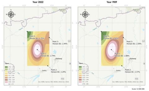
The comparison of humus content over a thirty-three-year period in the GIS program was assessed (Figure 3). Humus content in the soil of the Kostanay region, at the points being examined during long-term agricultural use, has changed from 1989 to 2022 at point 1. At point 3 and point 4, humus content decreased in 2022 (Figure 3). Comparative analysis of nitrate nitrogen was carried. Since this element is mobile and can vary during the whole growing season depending on various factors, including climate conditions, this indicator was considered to be the only form of nitrogen that was detected in early 1989 works for which a comparison could be made by years.
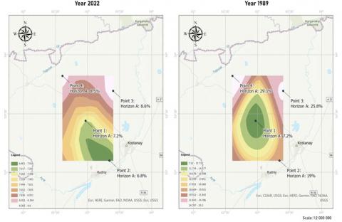
If we compare nitrate nitrogen content in 1989 in the fields, its content has decreased significantly compared to 2022 at the points 2, 3, 4. At points 3 and 4, the nitrate nitrogen content varied in horizon A. In 1989, and in 2022, nitrate nitrogen decreased at these points (Figure 4).
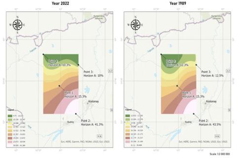
The content of mobile phosphorus forms showed slight changes over a thirty-three-year period, at points 2, 3, 4, a decrease in mobile phosphorus from 1 mg/kg to 2 mg/kg is seen, at point 1 the phosphorus content does not change in the upper horizons (Figure 5). A comparative analysis of the main indicators of soil fertility shows that phosphorus and humus content has not changed much over the 30 years of agricultural use. Nitrate nitrogen content has decreased, but this figure changes actively with even little variations in temperature and humidity.
Interpolation results show spatially correlated distances between humus points and north-south shift of data (Figure 6).
Spatial interpolation of nitrate nitrogen content through ArcGIS Geostatistical Analyst program shows correlation of the indicators with time (Figure 7).
The spatial interpolation of mobile phosphorus content in horizons A and B1 in Figure 8 does not show a large variation in values.
Figure 3. Comparative analysis of humus content in the soil of Kostanay region
Figure 4. Comparative analysis of nitrate nitrogen content in soil of Kostanay region
Figure 5. Comparative analysis of mobile phosphorus content in the soil of Kostanay region
Figure 6. Spatial interpolation of humus content in horizons A and B1 of the Kostanay region in ArcGIS geostatistical analyst program
Figure 7. Spatial interpolation of nitrate nitrogen content in the horizons A and B1 of the Kostanay region in geostatistical analyst program ArcGIS
Figure 8. Spatial interpolation of mobile phosphorus content in the horizons A and B1 of the Kostanay region in ArcGIS geostatistical analyst program
The results of the research showed that the annual plowing of the lands of the steppe zone is the main factor in soil degradation, the morphological properties of the profile, humus content, agrochemical, physicochemical properties of the soil change, which ultimately affects their fertility. On average, over 50 years, 19-22% of humus was lost during plowing of chernozem, and 28-30% of humus was lost during plowing of chestnut soils in Kazakhstan [17].
According to Amerguzhin [18] one of the factors of soil degradation is soil fatigue, which manifests itself in monoculture or with an excessively high proportion of one crop (for example, wheat) in the crop rotation. Basically, the processes of soil degradation that occur during soil fatigue are associated with the accumulation of the same type of organic residues, the same nature of their decomposition, disruption of the succession of microorganisms and the accumulation of toxic concentrations of some products of incomplete decomposition of organic residues. These processes are exacerbated by the accumulation of specific pests and diseases.
The high content of exchangeable potassium in the southern and ordinary chernozem is the result of their potential fertility, and its reduction is due to the decrease in organic matter and other nutrients during agricultural use [19, 20]. It should be highlighted that if exchangeable calcium is clearly accumulating in the most humid part of the chernozem profile, primarily due to biogenic processes, then metabolic magnesium is found here only marginally and it usually plays a minor role in exchange processes [21].
4.1 Estimation of kriging soil interpolation
Chernozem fertility is declining due to intense anthropogenic pressure and the ability to self-regulate and maintain the basic components of soil fertility is being lost. Soil enrichment with organic matter at a level of deficit-free and positive balance is a prerequisite for increasing the productivity of agroecosystems in obtaining sufficient quantities of high-quality products [22-24].
Changes in soil properties, inadequate knowledge of the links between environmental conditions and organic matter, limitations of data to provide small-scale variability of soil properties may contribute to the large variability of values.
Among geostatistical interpolation methods, the universal kriging method was the most accurate and informative. This conclusion relates to the results of research carried out on the territory of Kazakhstan.
4.2 Recommendations
Based on the studies carried out, it is necessary to carry out a set of measures to preserve and reproduce soil fertility in the Kostanay region: conduct an agro-ecological assessment of the entire territory, identify the degree of soil degradation, apply agricultural technologies taking into account soil characteristics, apply fertilizers. Conduct annual monitoring of the content of nutrients in the soil and apply fertilizers differentially to equalize the diversity of the soil cover.
It is necessary to introduce adaptive landscape farming systems that take into account not only the terrain, but also the features of the soil cover. In the use of complex soil cover, it is necessary to improve agricultural technologies for cultivating crops, while taking into account their biological capabilities.
The main results showed a decrease in the content of nitrate nitrogen and mobile phosphorus in the upper horizons of the soil in all the studied areas in the period from 1989 to 2021, a decrease in the content of humus in the upper horizons in the period from 1989 to 2021, with prolonged agricultural use of land, as well as minor changes in the amount of absorbed bases and the pH of the soil medium for a 30-year period.
Geostatistical analysis of spatial interpolation of nitrate nitrogen and humus content showed a noticeable correlation of indicators by points depending on time. Due to the availability of sufficient geostatistical methods, they are widely used to predict the spatial distribution of humus content in soil. For this reason, further research is needed to determine the optimal interpolation method for this purpose which will be suitable for assessing and mapping humus in the soil.
These studies are promising for further monitoring of the transformation of zonal properties of soil fertility during prolonged agricultural use, as well as assessment of changes in soil fertility using modern research methods. Further research can be aimed at assessing the transformation of soil fertility properties.
The research was carried out within the scientific and technical program: "Development of organic agriculture technologies for growing crops, taking into account the specifics of the regions, digitalization, and export" for 2021-2023, on the project topic: "Assessment of the agro-ecological state of agricultural land from the impact of the anthropogenic factor and determination of the degree of pollution of soils and agricultural systems of the steppe and dry steppe zones of the Kostanay region”.
[1] Guney, M., Yagofarova, A., Yapiyev, V., Schönbach, Ch., Kim, J.R., Inglezakis, V.J. (2020). Distribution of potentially toxic soil elements along a transect across Kazakhstan. Geoderma Regional, 21: e00281. https://doi.org/10.1016/j.geodrs.2020.e00281
[2] Jiang, L., Jiapaer, J., Bao, A., Kurban, A., Guo, H., Zheng, G., De Maeyer, P. (2019). Monitoring the long-term desertification process and assessing the relative roles of its drivers in Central Asia. Ecological Indicators, 104: 195-208. https://doi.org/10.1016/j.ecolind.2019.04.067
[3] Tleubaev, A.B., Rustembaev, B.E., Rakhimov, A.M. (2021). Application of mineral fertilizers in the main grain-growing regions of Kazakhstan. Problems of the Agricultural Market, 4(4): 104-112. https://doi.org/10.46666/2021-4.2708-9991.11
[4] Nukeshev, S.O., Eskhozhin, D.Z., Romanyuk, N.N., Akhmetov, E.S., Tleumbetov, K.M., Kosatbekova, D.Sh., Saktaganov, B.Zh. (2020). Technological and technical solutions to the problem of applying the main dose of mineral fertilizers in the precision farming system in Northern Kazakhstan. Novosti nauki Kazakhstana, 1(143): 176-187.
[5] Klebanovich, N.V., Oleshkevich, O.M., Sazonov, A.A., Kindeev, A.L., Genin, V.A. (2019). To Develop a Geoinformation Database of Spatial Information and Analytical Data Reflecting the Resistance of Various Types of Agricultural Landscape Lands to Man-Made Impacts: Research Report (Conclusion). Institute of Soil Science and Agrochemistry, Minsk.
[6] Myslyva, T.N., Kutsaeva, O.A., Podlesny, A.A. (2017). Comparison of the effectiveness of GIS-based interpolation methods for estimating the spatial distribution of humus in soil. Bulletin of the Belarusian State Agricultural Academy, 4: 146-152.
[7] Wadoux, A.M.J.-C., Marchant, B.P., Lark, R.M. (2019). Efficient sampling for geostatistical surveys. The European Journal of Soil Science, 70(5): 975-989. https://doi.org/10.1111/ejss.12797
[8] Samofalova, I.A. (2020). The use of geostatistical tools in the process of spatial analysis of organic carbon content in soils of the Basegi ridge. In: Digital Geography: Materials of the All-Russian Scientific and Practical Conference with International Participation, vol. 1. PGNIU, Perm, pp. 316-319.
[9] Zhao, K., Zhang, L., Dong, J., Wu, J., Ye, Z., Zhao, W., Ding, L., Fu, W. (2020). Risk assessment, spatial patterns and source apportionment of soil heavy metals in a typical Chinese hickory plantation region of southeastern China. Geoderma, 360: 114011. https://doi.org/10.1016/j.geoderma.2019.114011
[10] Kiboi, M.N., Ngetich, F.K., Fliessbach, A., Muriuki, A., Mugendi, D.N. (2020). Nutrient release from organic resources in Nitisols of the Central Highlands of Kenya. Geoderma Regional, 21: e00287. https://doi.org/10.1016/j.geodrs.2020.e00287
[11] Sun, B., Jia, S., Zhang, S., McLaughlin, N.B., Zhang, X., Liang, A., Chen, X., Wei, S., Liu, S. (2016). Tillage, seasonal and depths effects on soil microbial properties in black soil of Northeast China. Soil & Tillage Research, 155: 421-428. https://doi.org/10.1016/j.still.2015.09.014
[12] Negacz, K., Malek, Z., de Vos, A., Vellinga, P. (2022). Saline soils worldwide: Identifying the most promising areas for saline agriculture. Journal of Arid Environments, 203: 104775. https://doi.org/10.1016/j.jaridenv.2022.104775
[13] Vasilchenko, N.I., Bykov, A.N., Zvyagina, G.A. (2020). Reproduction of fertility of southern chernozems of Northern Kazakhstan. Agrarian Bulletin of the Upper Volga region, 2(31): 9-16. https://doi.org/10.35523/2307-5872-2020-31-2-9-16
[14] Zvyagin, G.A., Shaparny, E.E. (2018). Assessment of agrogenic transformation of agrochemical properties of chernozem soils of Northern Kazakhstan with minimal treatment system. Internauka, 40(74): 40-42.
[15] Akhmanova, A.U., Jalankuzov, T.D., Toregozhina, Zh.R. (2015). Local monitoring of arable lands of Kostanay region. KazNU Bulletin. Ecology series, 44(3): 56-61.
[16] Almanova, Zh.S., Kenzhegulova, S.O., Kalakova, M.E. (2021). The current state of soil fertility of arable soils of Fedorovsky district of Kostanay region. Bulletin of the Kursk State Agricultural Academy, 9: 81-86.
[17] Matynenko, I.A., Meshalkina, J.L., Rappoport, A.V., Shabarova, T.V. (2019). Spatial heterogeneity of some soil properties of the Botanical Garden of Lomonosov Moscow University. In Proceedings of the 9th SUITMA Congress, pp. 185-194. https://doi.org/10.1007/978-3-319-89602-1_22
[18] Amerguzhin, H.A. (2006). Agroecological assessment of soils of Kostanay region of Kazakhstan. Bulletin of the V.V. Dokuchaev Soil Institute, 58: 62-69.
[19] Fei, X., Lou, Z., Xiao, R., Ren, Z., Lv, X. (2022). Source analysis and source-oriented risk assessment of heavy metal pollution in agricultural soils of different cultivated land qualities. Journal of Cleaner Production, 341: 130942. https://doi.org/10.1016/j.jclepro.2022.130942
[20] Feng, W., Lu, H., Kang, J., Yan, P., Yao, T., Guan, Y., Jiang, C., He, M., Xue, Y., Yu, Q., Yan, Y. (2023). Optimized multilateral crop trade patterns can effectively mitigate phosphorus imbalance among the involved countries. Science of the Total Environment, 870: 161841. https://doi.org/10.1016/j.scitotenv.2023.161841
[21] Prabhakar, S.V.R.K. (2021). A succinct review and analysis of drivers and impacts of agricultural land transformations in Asia. Land Use Policy, 102: 105238. https://doi.org/10.1016/j.landusepol.2020.105238
[22] Zhang, D., Wu, L., Huang, S., Zhang, Z., Ahmad, F., Zhang, G., Shi, N., Xu, H. (2021). Ecology and environment of the Belt and Road under global climate change: A systematic review of spatial patterns, cost efficiency, and ecological footprints. Ecological Indicators, 131: 108237. https://doi.org/10.1016/j.ecolind.2021.108237
[23] Volkov, D.S., Rogova, O.B., Proskurnin, M.A., Farkhodov, Y.R., Markeeva, L.B. (2020). Thermal stability of organic matter of typical chernozems under different land uses. Soil & Tillage Research, 197: 104500. https://doi.org/10.1016/j.still.2019.104500
[24] Artemyeva, Z., Danchenko, N., Kolyagin, Yu., Kirillova, N., Kogut, B. (2021). Chemical structure of soil organic matter and its role in aggregate formation in Haplic Chernozem under the contrasting land use variants. Catena, 204: 105403. https://doi.org/10.1016/j.catena.2021.105403