Evaluating Spatial Data Infrastructure for Subak Management in Tabanan Regency, Bali, Indonesia

I Ketut Sardiana*![]() | Putu Perdana Kusuma Wiguna
| Putu Perdana Kusuma Wiguna![]()
© 2023 IIETA. This article is published by IIETA and is licensed under the CC BY 4.0 license (http://creativecommons.org/licenses/by/4.0/).
OPEN ACCESS
This investigation scrutinized the integration of geospatial intelligence in decision-making related to Subak management in Tabanan Regency, Bali. Focused on ascertaining comprehensive Subak data, evaluating local government readiness for Spatial Data Infrastructure (SDI) implementation, and constructing a web GIS-based Subak information system, this study was underpinned by a three-pronged methodological approach. Primary data was collected via interviewing Tabanan's Office of Agriculture personnel, supplemented by an in-depth secondary data analysis. Additionally, a web GIS, using QGIS and JavaScript, was developed. Findings revealed a significant deficit in the Office's preparedness for SDI implementation in Subak management due to the unavailability of critical SDI components. Consequently, a web GIS was constructed to facilitate Subak data dissemination. Usability testing suggested this system was 'easy' to use for 42.5% of respondents, while 52.5% found it 'very easy'. This research underscores the importance of Subak data provision and its potential role in decision-making processes for Subak preservation. The study was delimited to the evaluation of SDI in Tabanan Regency, and the development of a web-based GIS was executed using the waterfall method.
Subak, Spatial data infrastructure, web GIS
As a cornerstone of Balinese culture in Indonesia, Subak is a social organization that governs the distribution of water for rice field irrigation. The preservation of this system is integral to the sustainability of rice fields [1]. Effective data-sharing tools that provide pertinent geospatial data, encompassing diverse spatial objects such as area, pollution, fertilizer requirement, land conversion, and socio-economic parameters of Subak, have been proposed for conserving the Subak system. Spatial Data Infrastructure (SDI) and Web GIS are deemed to offer accurate geospatial data, enhancing data accessibility and utilization, and thus bolstering the decision-making process [2, 3].
Bali Province heavily relies on Subak for rice cultivation, its staple food, with Tabanan Regency, one of the largest Subak areas and rice producers, dedicating 28% of its total area to rice cultivation [4, 5]. The Tabanan Office of Agriculture holds the mandate for Subak data management and the implementation of SDI. Successful SDI development necessitates the presence of several components: legislation and policies, data accessibility, data and standards, and human resources [6-8]. Moreover, the SDI development should be accompanied by an information system for monitoring progress and facilitating data-sharing [9-11]. This underscores the need for assessing the current state of SDI, a cornerstone for evaluating SDI implementation for Subak data management and developing an information system as a data-sharing tool.
This research aimed to gather information on Subak in Tabanan, assess the local government's readiness for SDI implementation, and establish a web GIS-based Subak information system for data sharing among government agencies and stakeholders in Tabanan. Previous studies on Subak have primarily concentrated on mapping irrigated rice fields and discerning the socio-economic and cultural aspects of Subak [12-14], while SDI has been utilized and evaluated for lahar hazard mitigation and tourism village promotion [7, 8]. This research, therefore, holds significant implications for providing Subak data and developing an information system to facilitate the sharing of high-quality Subak data, thereby aiding decision making and the preservation of Subak. However, it is noteworthy that this research is limited to the evaluation of SDI in Tabanan Regency with respect to Subak data and the development of a web GIS using the waterfall method on existing Subak data.
2.1 Geospatial data
Geospatial data, or geodata, include information relating to locations on the earth's surface [15, 16]. Objects, events, and other real-world phenomena at a particular location can be mapped and identified using a coordinate system. Geospatial data are needed by every level of government, from local to regional and central. They can be processed to produce useful geospatial information to support various tasks and activities and play an essential role in decision-making [17].
In many cases, spatial data are spread across different agencies, institutions, or organizations according to their respective authorities and duties. More often than not, the available spatial data are incomplete and difficult to access and integrate [18]. Numerous constraints on data integration are the use of different software, data formats, structures, protocols, and policies, data duplication, and attribute inconsistencies. These have caused problems in realizing optimal data utilization. Moreover, the provision of spatial data still revolves around the nature of data visualization and is yet to realize easy access and data utilization in policy-making.
2.2 Spatial data infrastructure
Spatial Data Infrastructure (SDI) is a system to manage spatial data that has integrated components (human resources, policy and legislation, technology, standardization, and spatial data), thus enabling data sharing and ease of access to increase the effectiveness and efficiency of spatial data utilization in an area [17-19]. SDI is a computer-based system containing maps or spatial data [20]. It was created to facilitate access to data contained in government agencies and competent private institutions and the process of manipulating and analyzing data, as well as presenting the results of data analysis onto paper [21].
SDI is built based on the information needed by users. In addition to data retrieval and analysis, this system is also useful as a tool to provide considerations in making decisions and plans in certain fields. However, SDI can only be applied at all levels if supported by active cooperation between map data producers and users [22].
2.3 Subak
Subak is a traditional rice field irrigation system in Bali, Indonesia, with an agricultural socio-religious concept and has existed and been applied for a long time [23-25]. The term subak is legally defined in Provincial Regulation Number 9 of 2012 as a traditional organization of water use and plant management that is both socio-agrarian and religious at the rice field level by the indigenous people of Bali [26]. Balinese people are an agrarian society that preserves and adheres to cultural and religious values. This is evident in the Balinese subak system, which is rich in historical and cultural values and has been actively practiced to this day.
Subak is governed by a traditional leader called Pekaseh and usually also works as a farmer. Subak is a traditional organization that refers to the concept of Tri Hita Karana, which originated from Hinduism. Tri Hita Karana means a harmonious relationship among people, with the environment, and with God. Therefore, subak is a form of irrigation that is able to accommodate the dynamics of the socio-cultural system of the local community. Subak is characterized by the spirit of mutual cooperation in an effort to obtain water with the aim of meeting water needs in producing food crops [1].
According to the Bali Cultural Office, subak has existed in Bali since 882 AD. This long-standing system proves that the Balinese people care deeply about its existence. The United Nations Educational, Scientific, and Cultural Organization (UNESCO) also recognizes the substantial historical value of the Balinese subak system and, considering such a rich history, feels the need to protect, preserve, and develop it to prevent its extinction. UNESCO finally approved and designated subak in Bali as a world cultural heritage on June 29, 2012, at the 36th session of the UNESCO World Heritage Committee in Saint Petersburg, Russian Federation [26-29].
3.1 Research location
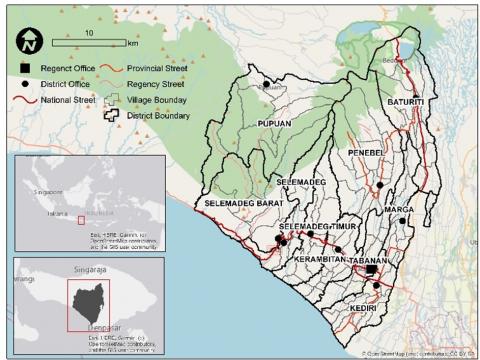
Tabanan, one of the regencies in Bali Province, is located in the southern part of the island of Bali. Geographically, it spans from 114°54'52" to 115°12'57" E and from 8°14'30" to 8°30'70" S, covering an area of 839.33 km2. Tabanan consists of ten districts: Tabanan, Kediri, Kerambitan, Selemadeg, Selemadeg Barat, Selemadeg Timur, Penebel, Pupuan, Marga, and Baturiti [30, 31]. It is bordered by Buleleng Regency to the north, Badung Regency to the east, the Indian Ocean to the south, and Jembrana Regency to the west. The leading economic sector is agriculture because the livelihood of the residents and existing land use are primarily associated with farming practices [32, 33]. Figure 1 shows the position of the research area.
Figure 1. Map of the research location
Table 1. Data collection methods
|
No. |
Data Collection Method |
Objective |
|
1 |
Interviews |
To seek information from trusted sources regarding the existence of SDI and spatial data on subak |
|
2 |
Questionnaire |
To collect relevant information about SDI and spatial data on subak during the interview |
|
3 |
Observation |
To gather various data and information so as to confirm statements obtained in the interviews and questionnaires |
|
4 |
Document studies |
To discover theoretical foundations, frameworks for thinking, and research hypotheses and to understand previous documents and research on SDI and web GIS development |
Table 2. Questionnaire about the readiness of SDI
|
SDI Component/Question |
|
1. Legislation and Policies
|
|
2. Access
|
|
3. Human Resources
|
|
4. Data and Standards
|
3.2 Research design
This research employed a qualitative design, which is conducted by examining the perspectives of respondents or informants [34]. It comprised three stages of data acquisition and analysis. In the first stage, primary data were collected by interviewing the personnel or staff members of the Tabanan Office of Agriculture and observing the current spatial data availability and SDI status. Second, relevant reports and documents were gathered to obtain secondary data on existing SDI. Finally, the third stage focused on data analysis and developing a web GIS-based information system as a means of sharing spatial data on subak.
3.3 Data collection
Data were collected through interviews, questionnaires, observations, and document studies, with the objectives summarized in Table 1.
3.3.1 Interviews
Interviews were conducted to find out information on SDI from four aspects: legislation and policies, data accessibility, human resources, and data and standards. The informants were the heads of the agricultural data sectors, the heads of the agricultural extension sectors, and five staff members responsible for handling data. A questionnaire was also used to record and summarize the results of the interviews. Table 2 shows the questionnaire for SDI readiness. The questionnaire also includes respondent data such as name, contact, position and address.
3.3.2 Observations
Observations were used to confirm findings from the interviews and questionnaires. Observations were conducted at the Tabanan Office of Agriculture to retrieve data related to subak, data management system, internet network, the availability of GIS staff, and relevant regulations and standards (including Regent decrees, policies, standard operational procedures, and national or provincial standards).
3.4 Web GIS development
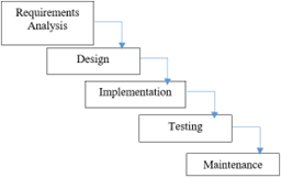
The waterfall method was employed to develop the web GIS. The system allows for repeated cycles (iterative) in smaller portions each time (incremental), meaning that software developers can learn from earlier versions or developments of its applications [35, 36]. Figure 2 shows an illustration of the waterfall method.
Figure 2. Illustration of the waterfall model
The web GIS display used qgis2web (a plugin for QGIS application), Leaflet (leaflet, js) library and its plugins, and maps from OpenStreetMap and Google Satellite Imagery. It was developed with bootstrap (a CSS framework), PHP as the backend language, and MySQL as the database. JavaScript processes data on the client side and presents more interactive web components, adding functionality and convenience to web pages [37]. Leaflet JS is an open-source JavaScript library that is used widely to build a web mapping application. It supports most mobile and desktop platforms, as well as HTML5 and CSS3, and is used by many web mapping sites [38]. PHP is a server-side scripting language that can be embedded and inserted into HTML and is designed for web development [39]. MySQL is a database management system (DBMS) commonly used by web-based application programmers [40]. MySQL offers various advantages over other DBMS because it is freely available, powerful, and frequently updated. Moreover, MySQL often bundles with web servers, making installation easier.
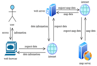
The architecture of the web GIS allows users to request spatial information from the web server, which then provides a response with a digital map. In other words, for each request, users will receive the desired spatial data in a digital map. In its implementation, subak is spatially expressed as polygons.
The web GIS was developed with a user-friendly front-end design with different features: adjustable legends that can show and hide layers, navigation (zoom in, zoom out, pan), pop-up attribute identification, subak search, and downloadable data. Figures 3 and 4 show the use case diagram and the system architecture of the web GIS development.
Figure 3. The use case diagram of the web GIS development
Figure 4. System architecture of web GIS
3.5 System evaluation
Following the development, the web GIS was evaluated with usability testing to measure user satisfaction [41]. User testing can directly provide information on the user’s experience and any problems faced when utilizing the system. In this research, 30 respondents from the Tabanan Office of Agriculture were given eight tasks to be completed on the web GIS app. Respondents were between 25 and 50 years old and familiar with the features and functions of laptops and mobile phones. Afterward, they were asked to score the difficulty of completing each task on a scale of 1 (very difficult) to 5 (very easy), as seen in Table 3. The scores were then calculated to determine the task completion rate (in percent) to evaluate the system (Table 4).
Table 3. Tasks to complete by respondents in the web GIS evaluation
|
No. |
Tasks |
Score |
||||
|
1 |
2 |
3 |
4 |
5 |
||
|
1 |
Display the main page |
|||||
|
2 |
Select basemap |
|||||
|
3 |
Download data |
|||||
|
4 |
Filter data |
|||||
|
5 |
Using attribute identification |
|||||
|
6 |
Activate/deactivate a legend |
|||||
|
7 |
Navigate (zoom in and zoom out) |
|
|
|
|
|
|
8 |
Print data |
|||||
Table 4. System evaluation categories based on task completion rates for the developed web GIS
|
No. |
Task Completion Rate |
Category |
|
1 |
80–100% |
Very Good |
|
2 |
60–79.99% |
Good |
|
3 |
40–59.99% |
Moderate |
|
4 |
20–39.99% |
Poor |
|
5 |
0–19.99% |
Very Poor |
Based on the interview data, the Tabanan Office of Agriculture is not fully prepared to implement Spatial Data Infrastructure (SDI) to support subak management. From the legislation and political aspect, no regulation has been laid to modulate SDI by the Regent. The only regulation pertinent to spatial data is issued for regional planning at the regency level. Related to access, the main governmental institution responsible for maintaining the subak data is the Office of Agriculture, even though others like the Culture and Tax Offices also use these data in their database to preserve subak as a world cultural heritage and regulate subak practices. Coordinating the offices to produce, disseminate, and share the subak data is difficult because they have dissimilar tasks and responsibilities. Moreover, the data accuracy and details often differ across the offices and are usually stored in formats other than shapefile, e.g., printed versions, pdf files, or office formats. Data can only be shared after an official request letter has been submitted to the office in question and transferred using a USB flash drive or emailed. In addition, data sharing between the Office of Agriculture and other offices or agencies at the regency, provincial, and national levels is considered rare.
In terms of human resources, the Office employed 214 people at the time of the research. Like in other governmental institutions, personnel are assigned to different sections or units with their respective tasks and activities. However, further observations showed that no unit is responsible for data management. Also, the staff members do not have an educational background in Earth Sciences (i.e., Geodesy, Geomatics, or Geography) and have not attended any courses or training related to spatial data, hardware management (e.g., servers, computers, dedicated server rooms), and map server programs for the management and publication of geospatial data. Employing more personnel from the geoscience fields is potentially challenging because the Office can only hire staff once a year through the selection tests held by the national government.
Table 5. Subak data attributes for Tabanan Regency
|
Attribute Name |
Type |
Description |
|
NAMA_SUBAK |
String |
Name of subak |
|
DESA |
String |
Name of the village where subak is located |
|
KECAMATAN |
String |
Name of the district where subak is located |
|
KABUPATEN |
String |
Name of the regency where subak is located |
|
JML_PETANI |
String |
Number of farmers, including land owners and sharecroppers |
|
AWIG-AWIG |
String |
Awig-awig is a set of rules that contain provisions governing all subak members, including subak management. |
|
JNS_TANAH |
String |
The type of soil in subak rice fields |
|
JNS_IRIG |
String |
Irrigation type: technical (or permanent irrigation canal with concrete lining), semi-technical (semi-permanent), or non-technical (not permanent) |
|
SUMBER_AIR |
String |
Water source: from dams or springs |
|
KOND_IRIGASI |
String |
General conditions of irrigation channels: good, moderate, or bad/damaged |
|
POLA_TNM |
String |
Arrangement of planting activities on a plot of land, including the layout and order of plants throughout the year (tillage, cropping or cultivating seasons, and fallow periods) |
|
JDWL_TANAM |
String |
Cropping schedule in an area for a year, including land preparation, planting, and harvesting; usually presented in a month or two-week period |
|
SIST_TANAM |
String |
Management and regulation of planting methods to provide an optimal space for plant growth and development |
|
PENG_LAHAN |
String |
A process of mechanically changing the nature of the soil using tractors or plows (traditional) to provide desirable arable land that is suitable for plant growth |
|
PROD_TON/HA |
Decimal Number |
The number of agricultural yields obtained over a certain period; mostly expressed as tonnes per ha |
|
MASL_UMUM |
String |
Problems encountered in subak rice fields |
|
HAMA |
String |
Undesirable organisms in rice fields that are considered harmful to plants |
Regarding data and standards, the Office stores several spatial data on subak distribution in Tabanan in a shapefile format, although without metadata. The subak data were produced in 2017 with Universal Transverse Mercator (UTM) coordinates from surveys and participatory mapping with the help of pekaseh, or head of subak rice fields. However, the mapping results have never been followed up, updated, or used. As listed in Table 5, the data attributes comprise the name of the subak, the administrative location (village, district, and regency), the number of farmers, awig-awig or a set of rules containing provisions to govern all subak members, soil type, irrigation type, water source, planting arrangement, planting schedule, planting system, land tillage, production, problems, and pests.
These subak data, however, cannot be shared and used across governmental institutions in Tabanan because the Office of Agriculture does not have a web GIS to store, display, and share spatial data. One of the challenges is that the Office has limited funding for servers and Geographic Information System (GIS) software; hence, no special internet subscription to the SDI server and its bandwidth. The current status (i.e., aspects) of SDI for subak management in Tabanan is explained in Table 6.
Table 6. Current conditions of Spatial Data Infrastructure (SDI) for subak management
|
No. |
SDI Category |
Condition |
|
1 |
Data |
Spatial data on subak are stored as shapefiles, but the spatial information, attributes, and metadata are incomplete. |
|
2 |
Standards |
No standards are applied to the data format and attribute. |
|
3 |
Access |
Data can be accessed after submitting an official request letter. No technologies are available to access the data. |
|
4 |
Policies |
No policies are regulating SDI. |
|
5 |
Human resources |
Despite the many staff members, none have the relevant educational backgrounds or skills to manage and work with GIS and SDI. |
Based on the above situations, SDI development should be focused on data availability and access network. To assist the Tabanan Office of Agriculture in preparing SDI, a web GIS has been built to store, display, and download the subak data and to give government workers from different departments, agencies, or offices and community members access to search, discover, and visualize geospatial data related to subak. At the same time, the web GIS increases the readiness of the Office for developing SDI.
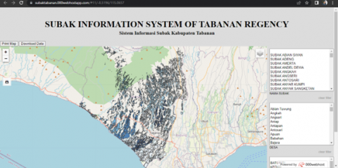
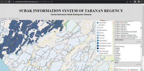
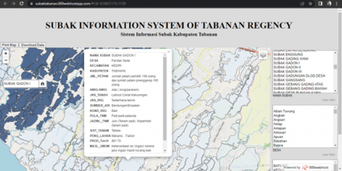
The web GIS was developed with a user-friendly front-end view containing legends, navigation (zoom in, zoom out, measure), data filters tool, search features, a pop-up window for attributes, and downloadable data (Figure 5). Users can access maps online and quickly display their data attributes (see Table 5) using the identification feature with just one click on the data. This identification feature allows users to understand the information contained in the data attributes using a pop-up window (Figure 6).
In addition, as seen in Figure 7, the developed system also has a dynamic map legend where users can activate and deactivate one or several items in the legend. Another important component is the search feature (Figure 8). Users can find the location of a specific subak and identify its data attributes merely by typing the name of the subak in the search field.
Figure 5. Front-end view of the developed web GIS
Figure 6. Pop-up window showing data attributes
Figure 7. Dynamic map legend
Figure 8. Subak search function with pop-up data attributes
Figure 9. An example of filter by village showing the name and location of existing subak systems
Figure 10. Google satellite basemap with data filter result
Figure 11. Distance and area measurements with google satellite basemap
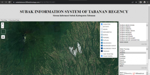
The web GIS also has data filters by subak name, village, and district. As seen in the example in Figure 9, to find which subak is located in Angseri Village, users can click on the village name, and the system will return with the locations and names of existing subak. Another feature is the option to change the basemap on the screen between OpenStreetMap and Google Satellite Image. The basemap from OpenStreetMap allows users to find locations easier, while the one from Google Satellite can help determine the boundaries of a subak and changes in land utilization (Figure 10). The next feature is the ability of the system to measure distance and area on the displayed map, which can also be used to determine the extent of land-use change (Figure 11). Coordinates for each measurement point are recorded and displayed on the system map.
The last features are map printing and data download that allow users to obtain subak data and maps. The primary user of the developed web GIS is the Tabanan Office of Agriculture and related offices in the regency. With the map print feature, users can print a map in a PNG format according to the display on the system. Meanwhile, the download feature produces data in a GeoJSON format. This web GIS is published on a free hosting site to help the Office with cost-effective maintenance. It can be accessed at this address https://subaktabanan.000webhostapp.com/.
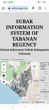
With a web browser application, the web GIS can also be accessed from mobile devices like smartphones or tablet computers. It has a responsive design in that the website layout will automatically adjust to the user's screen size. As seen in Figure 12, the mobile view clearly displays the system’s name and all the designed features.
According to the system evaluation, the developed web GIS can be easily used, navigated, and understood by the respondents (i.e., personnel or staff members of the Tabanan Office of Agriculture). Of the 30 respondents, 52.5% rated the task completion on the web GIS as very easy and 42.5% as easy. Only 5% found it moderately difficult to complete the assigned tasks. Further, 22 users (73%) thought it was very easy to display the main page by clicking on the provided link, and 18 users (60%) considered the zoom-in and zoom-out features very easy. The user testing results are presented in detail in Table 7. The respondents also gave suggestions for improving the web GIS, including adding the contact information of the Office, more non-spatial information related to subak in addition to the spatial data, and a login feature to prevent data misuse and developing the web GIS into a mobile application.
Figure 12. Mobile view of the developed web GIS for Subak
There is an increasing number of research reporting the use of GIS-based information systems in agriculture [42-45]. With technological advances, the subak web GIS is expected to solve issues frequently faced in subak data inventory and management and other spatial problems like land management, suitability, and conversion. The ability of the subak web GIS to switch the basemap between OpenStreetMap and Google Satellite Image, the designed web GIS can help identify the location of subak rice fields and track land-use conversion. Through a comprehensive data inventory, the identification feature can produce a combination of spatial and non-spatial data (attributes). Thus, the developed web GIS helps promote agricultural management with an integrated system and improve subak sustainability by incorporating the spatial and non-spatial dimensions of farming practices in making agricultural policies. Web GIS development for subak is the first time it has been carried out. Research on GIS for agriculture in Bali mainly covers land suitability, soil fertility status and disaster-related research [46-51].
Table 7. User testing results
|
No |
Task |
Score |
||||
|
1 |
2 |
3 |
4 |
5 |
||
|
1 |
Display the main page |
0 |
0 |
0 |
8 |
22 |
|
2 |
Select basemap |
0 |
0 |
2 |
15 |
13 |
|
3 |
Download data |
0 |
0 |
2 |
13 |
15 |
|
4 |
Filter data |
0 |
0 |
3 |
13 |
14 |
|
5 |
Using attribute identification |
0 |
0 |
2 |
17 |
11 |
|
6 |
Activate/deactivate a legend |
0 |
0 |
1 |
12 |
17 |
|
7 |
Use zoom (in and out) |
0 |
0 |
0 |
12 |
18 |
|
8 |
Print data |
0 |
0 |
2 |
12 |
16 |
|
Total (Frequency) |
0 |
0 |
12 |
102 |
126 |
|
|
Total (%) |
0 |
0 |
5 |
42.5 |
52.5 |
|
The Tabanan Office of Agriculture is not entirely prepared to establish a full-fledged spatial data infrastructure (SDI) for subak management. Even though the subak data are available at the Office, most of the SDI aspects are lacking, including no standards for data format and attribute, no technological application to access the data, no policies regulating SDI, and no human resources with the necessary educational background and skills for SDI management. Based on the task completion rate, the designed web GIS is generally easy (according to 42.5% of the respondents) and very easy (52.5%) to use and navigate. It suggests that web GIS can solve problems frequently faced in managing subak data and sustaining the existence and productivity of subak rice fields.
Effective SDI development must be preceded by issuing data standards and sharing policies and building the necessary technical and human capacity. Meanwhile, the Office of Agriculture is expected to develop concrete strategies and plans to build up the critical components of SDI systematically. Relevant training and education for staff members should also be prioritized.
This work is supported by the Faculty of Agriculture, Udayana University, Indonesia.
[1] Norken, I.N., Suputra, I.K., Arsana, I.G.K. (2015). Water resources management of Subak irrigation system in Bali. Applied Mechanics and Materials, 776: 139-144. https://doi.org/10.4028/www.scientific.net/AMM.776.139
[2] Ajmi, M., Hamza, M.H., Labiadh, M., Yermani, M., Khatra, N.B., Al-Thubaiti, A.S., El Arrim, A. (2014). Setting up a Spatial Data Infrastructure (SDI) for the ROSELT/OSS Network. Journal of Geographic Information System, 6: 150-161. http://dx.doi.org/10.4236/jgis.2014.62016
[3] Zwirowicz-Rutkowska, A., Michalik, A. (2016). The use of spatial data infrastructure in environmental management: An example from the spatial planning practice in Poland. Environmental Management, 58(4): 619-635. https://doi.org/10.1007/s00267-016-0732-0
[4] Dyatmikawati, P. (2017). Functions of customary law in managing water management within farmers’ organization: Case of Subak Kedua, Denpasar City, Bali province, Indonesia. Jurnal PIPSI (Jurnal Pendidikan IPS Indonesia). 2(2): 33-37. https://doi.org/10.26737/jpipsi.v2i2.309
[5] Trigunasih, N.M., Lanya, I., Hutauruk, J., Arthagama, I.D.M. (2017). Spatial numeric classification model suitability with Landuse change in Sustainable food agriculture zone in Kediri sub-district, Tabanan Regency, Indonesia. IOP Conference Series: Earth and Environmental Science, 98: 1-14. https://doi.org/10.1088/1755-1315/98/1/012046
[6] Tripathi, A.K., Agrawal, S., Gupta, R.D. (2020). Cloud enabled SDI architecture: A review. Earth Science Informatics, 13: 211-231. https://doi.org/10.1007/s12145-020-00446-9
[7] Permatasari, A.L., Suherningtyas, I.A., Wiguna, P.P.K. (2020). Analysis of local spatial data infrastructure to support volcanic mudflow mitigation along Putih River. Magelang Regency, Central Java Province, Indonesia. Forum Geografi, 34(1): 66-76. https://doi.org/10.23917/forgeo.v34i1.11169
[8] Sardiana, I.K., Purnawan, N.L.R., Wiguna, P.P.K., Suyarto, R., Kusmiyarti, T.B. (2021). Analysis of spatial data infrastructure (SDI) to support tourism village promotion in Badung regency, Bali, Indonesia. The Indonesian Journal of Geography, 53(3): 179-184. https://doi.org/10.22146/ijg.52556
[9] Jabbour, C., Rey-Valette, H., Maurel, P., Salles, J.M. (2019). Spatial data infrastructure management: A two-sided market approach for strategic reflections. International Journal of Information Management, 45: 69-82. https://doi.org/10.1016/j.ijinfomgt.2018.10.022
[10] Maphale, L., Smit, J.L. (2020). A theoretical proposition for spatial data infrastructure on-going improvement. ISPRS International Journal of Geo-Information, 10(1): 1-16. https://doi.org/10.3390/ijgi10010009
[11] Trystuła, A., Dudzińska, M., Źróbek, R. (2020). Evaluation of the completeness of spatial data infrastructure in the context of cadastral data sharing. Land, 9(8): 1-18. https://doi.org/10.3390/land9080272
[12] Arisena, G.M.K., Krisnandika, A.A.K., Darmawan, D.P. (2020). Social economy and digital mapping of Subak Sembung ecotourism. Agriekonomika, 9(2): 231-240. https://doi.org/10.21107/agriekonomika.v9i2.8754
[13] Suryada, I.G.A.B. (2020). Spatial meanings imbedded in cultural landscape of subak in Denpasar, the case study of pura Batu Bintang subak Sanglah. The First International Conference on Cultural Communication and Space (ICCCS).
[14] Darmawan, D.P., Arisena, G.M.K., Utami, N.W.F., Krisnandika, A.A.K. (2021). The dynamics of the social network of urban farmers in subak Sembung Denpasar. Agris On-line Papers in Economics and Informatics, 13(2): 51-58. https://doi.org/10.7160/aol.2021.130204
[15] Putra, T.Y.D., Sekimoto, Y., Shibasaki, R. (2019). Toward the evolution of national spatial data infrastructure development in Indonesia. ISPRS International Journal of Geo-Information, 8(6): 1-27. https://doi.org/10.3390/ijgi8060263
[16] Goyal, H., Sharma, C., Joshi, N. (2017). An integrated approach of GIS and spatial data mining in big data. International Journal of Computer Applications, 169(11): 1-6. https://doi.org/10.5120/ijca2017914012
[17] Hu, Y., Li, W. (2017). Spatial data infrastructures. The Geographic Information Science & Technology Body of Knowledge, John P. Wilson (ed.). https://doi.org/10.22224/gistbok/2017.2.1
[18] Bill, R., Blankenbach, J., Breunig, M., Haunert, J.H., Heipke, C., Herle, S., Werner, M. (2022). Geospatial information research: State of the art, case studies, and future perspectives. PFG-Journal of Photogrammetry, Remote Sensing and Geoinformation Science, 90: 349-389. https://doi.org/10.1007/s41064-022-00217-9
[19] Hendriks, P., Dessers, E., Hootegem, G. (2012). Reconsidering the definition of a spatial data infrastructure. International Journal of Geographical Information Science-GIS, 26(8): 1-16. https://doi.org/10.1080/13658816.2011.639301
[20] Nurdin, N., Pettalongi S.S., Mangasing, M. (2021). Implementation of geographic information system based on Google Maps API to determine Bidikmisi scholarship recipient distribution in Central Sulawesi, Indonesia. Journal of Humanities and Social Sciences Studies (JHSSS), 3(12): 38-53. https://doi.org/10.32996/jhsss
[21] Matheus, R., Janssen, M., Maheshwari, D. (2020). Data science empowering the public: Data-driven dashboards for transparent and accountable decision-making in smart cities. Government Information Quarterly, 37(3): 101284. https://doi.org/10.1016/j.giq.2018.01.006
[22] Vancauwenberghe, G., Dessers, E., Crompvoets, J., Vandenbroucke, D. (2014). Realizing data sharing: The role of spatial data infrastructures. Open Government: Opportunities and Challenges for Public Governance, 155-169. https://doi.org/10.1007/978-1-4614-9563-5_10
[23] Lanya, I., Subadiyasa, N.N., Hutauruk, J. (2017). Subak land information system based on remote sensing and geographic information system in Denpasar City. Geoplanning: Journal of Geomatics and Planning, 4(2): 225-232. https://doi.org/0.14710/geoplanning.4.2.225-232
[24] Norken, I.N. (2019). Efforts to preserve the sustainability of Subak irrigation system in Denpasar City, Bali Province, Indonesia. MATEC Web of Conferences, 276: 1-13. https://doi.org/10.1051/matecconf/201927604002
[25] Yuliana, E.D., Ayu, P.D.W., Pradipta, G.A., Ali, A. (2019). Reasons Subak conserving irrigation water resources. In Proceedings of the International Conference on Industrial Engineering and Operations Management, Toronto, Canada, pp. 1312-1317.
[26] Lestari, N.P.N.E., Sunia, W., Wikayanthi, N.W., Sinarti, N.N. (2017). Empowerment of “Subak” in development of sustainable eco-tourism village in Bali Indonesia (Case study of Jatiluwih Village, Bali Province, Indonesia). International Journal of Economics, Commerce and Management, 5(6): 796-810.
[27] Prastyadewi, M.A., Susilowati, I., Iskandar, D.D. (2020). Preserving the existence of Subak in Bali: The role of social, cultural, and economic agencies. Economia Agro-alimentare/Food Economy: An International Journal on Agricultural and Food Systems, 22(3): 1-20. https://doi.org/10.3280/ecag3-2020oa11045
[28] Suryada, I.G.A.B., Dwijendra, N.K.A., Sueca, N.P. (2019). The role of power in the existence of Subak cultural landscape in Denpasar, Bali. International Journal of Current Advanced Research, 8(1): 16810-16814. https://doi.org/10.24327/ijcar.2019.16814.3122
[29] Rahmi, D.H., Setiawan, B. (2020). Pressures on the Balinese world cultural landscape heritage: The case of Jatiluwih Subak Village, IOP Conf. Series: Earth and Environmental Science, 501: 1-10. https://doi.org/10.1088/1755-1315/501/1/012032
[30] Statistical Beureau of Tabanan Agency. (2020). Tabanan in Numbers. Statistical Beureau of Tabanan Agency, Tabanan.
[31] Trigunasih, N.M., Wiguna, P.P.K. (2020). Land suitability for rice field and conservation planning in Ho Watershed, Tabanan Regency, Bali Province, Indonesia. Geographia Technica, 15(1): 124-131. https://doi.org/10.21163/GT_2020.151.11
[32] Yulandari, A.N., Sudarma, I.M., Arisena, G.M.K. (2021). Functional change of agricultural land in Tabanan Regency, Bali (Case study in Subak Jadi, Kediri District). Agriecobis: Journal of Agricultural Socioeconomics and Business, 4(1): 13-21. https://doi.org/10.22219/agriecobis
[33] Sutjana, I. (2012). Balinese agriculture in a changing world. Indonesia Journal of Biomedical Science, 2(1): 1-9. https://doi.org/10.15562/ijbs.v2i1.49
[34] Hammarberg, K., Kirkman, M., de Lacey, S. (2016). Qualitative research methods: When to use them and how to judge them. Human Reproduction, 31(3): 498-501. https://doi.org/10.1093/humrep/dev334
[35] Mwangi, E., Kimani, S., Mindila, A. (2019). A framework for web GIS development: A review. International Journal of Computer Applications, 178(16): 6-10. https://doi.org/10.5120/ijca2019918863
[36] Papua, O., Kumaat, J., Runtuwene, J., Rompas, P. (2018). Web GIS university for planning infrastructure. In the 7th Engineering International Conference (EIC): Engineering International Conference on Education, Concept and Application on Green Technology, pp. 330-334. https://doi.org/10.5220/0009010803300334
[37] Kulawiak, M., Dawidowicz, A., Pacholczyk, M. (2019). Analysis of server-side and client-side Web-GIS data processing methods on the example of JTS and JSTS using open data from OSM and geoportal. Computers & Geosciences, 129: 26-37. https://doi.org/10.1016/j.cageo.2019.04.011
[38] Edler, D., Vetter, M. (2019). The Simplicity of Modern Audiovisual Web Cartography: An Example with the Open-Source JavaScript Library leaflet.js. KN-Journal of Cartography and Geographic Information, 69(1): 51-62. https://doi.org/10.1007/s42489-019-00006-2
[39] Alih, S., Ogala, E. (2019). Concept of web programming: An overview of PHP Vol. 1. International Journal of Scientific and Engineering Research, 10(12): 1-6.
[40] Koo, K.Y., de Battista, N., Brownjohn, J. (2011). SHM data management system using MySQL database with MATLAB and web interfaces. In Proceedings of the 5th International Conference on Structural Health Monitoring of Intelligent Infrastructure (SHMII-5), Cancún, México, pp. 1-9.
[41] Rohandi, M., Husain, N., Bay, I.W. (2021). Usability testing of intensive course mobile application using the usability scale system. ILKOM Jurnal Ilmiah, 13(3): 252-258. https://doi.org/10.33096/ilkom.v13i3.821.252-258
[42] Ismanto, H., Doloksaribu, A., Susanti, D.S. (2020). Web GIS-based land suitability using remote sensing technology in Merauke Regency of Papua. Journal of Engineering Research and Application, 10(4): 58-64. https://doi.org/10.9790/9622-1004025864
[43] Mani, J.K., Varghese, A.O. (2018). Remote sensing and GIS in agriculture and forest resource monitoring. Geospatial Technologies in Land Resources Mapping, Monitoring and Management, 377-400. https://doi.org/10.1007/978-3-319-78711-4_19377
[44] Mathenge, M., Broerse, J.E.W., Sonneveld, B. (2022). Application of GIS in agriculture in promoting evidence-informed decision making for improving agriculture sustainability: A systematic review. Sustainability, 14: 1-15. https://doi.org/10.3390/su14169974
[45] Sarmah, K., Deka, C., Sharma, U., Sarma, R. (2018). Role of GIS-based technologies in sustainable agriculture resource planning & management using spatial decision support approach. International Journal of Innovative Research in Engineering & Management, 5(1): 30-34. https://doi.org/10.21276/ijirem.2018.5.1.7
[46] Trigunasih, N.M., Wiguna, P.P.K. (2022). Identification of soil fertility status of Subak rice fields based on soil chemical properties in Denpasar City, Bali, Indonesia. African Journal of Food, Agriculture, Nutrition and Development, 22(10): 21807-21824. https://doi.org/10.18697/ajfand.115.20880
[47] Trigunasih, N.M., Wiguna, P.P.K. (2020). Land suitability for rice field and conservation planning in Ho Watershed, Tabanan Regency, Bali Province, Indonesia. Geographia Technica, 15(1): 124-131. https://doi.org/10.21163/GT_2020.151.11
[48] Kartini, N.L., Wiguna, P.P.K., Fudholi, A. (2023). Analysis of organic waste decomposition and quality of organic fertilizer using earthworms and black soldier fly (BSF). International Journal of Design & Nature and Ecodynamics, 18(2): 465-471. https://doi.org/10.18280/ijdne.180226
[49] Wiguna, P.P.K., Sutari, N.W.S., Febriarta, E., Permatasari, A.L., Suherningtyas, I.A., Pulungan, N.A.H.J., Sukraini, T.T., Gani, M. (2022). Spatial analysis of mangrove distribution using Landsat 8 OLI in Badung Regency and Denpasar City, Bali Province, Indonesia. Forum Geografi, 36(1): 21-29. https://doi.org/10.23917/forgeo.v36i1.14711
[50] Wiguna, P.P.K. (2021). Using big global database to analyze impact of webnews to tourist visits due to the 2017 eruption of Agung Volcano, Bali, Indonesia. Geographia Technica, 16(2): 40-52. https://doi.org/10.21163/GT_2021.162.04
[51] Sukraini, T.T., Yasa, I.M.A., Wiguna, P.P.K. (2022). Comparing choropleth and graduated symbols: How different map types affect public understanding in COVID-19 map reading in Badung Regency, Bali, Indonesia. Geographia Technica, 17(1): 151-167. https://doi.org/.10.21163/GT_2022.171.12