Fernando Morante-Carballo*![]() | María José Domínguez-Cuesta
| María José Domínguez-Cuesta![]() | Nataly Paz-Salas
| Nataly Paz-Salas![]() | Jenifer Malavé-Hernández
| Jenifer Malavé-Hernández![]() | Paúl Carrión-Mero
| Paúl Carrión-Mero![]()
© 2023 IIETA. This article is published by IIETA and is licensed under the CC BY 4.0 license (http://creativecommons.org/licenses/by/4.0/).
OPEN ACCESS
Coastal regions are increasingly recognised as prime locations for recreational tourism. Among these, the province of Manabi, Ecuador, with its distinct coastal cliff geomorphology, has considerable tourist appeal. However, a major seismic event in 2016, registering Mw 7.8, resulted in significant geomorphological alterations at the coastal level. This study sought to characterise the geomorphology of beach-cliff systems in Manabi province, utilising Geographic Information Systems (GIS) to identify the geomorphological changes induced by the 2016 earthquake, with the objective of informing sustainable management strategies. GIS was employed to discern the geomorphological alterations in the beach-cliff systems and compute their retreat rates. A Strengths, Weaknesses, Opportunities, and Threats (SWOT) analysis facilitated understanding of the current state of the cliffs, critical for devising coastal and tourism management strategies. The study area encompassed the beach-cliff systems of Canoa, Bahia de Caraquez, Crucita, Santa Marianita, San Lorenzo, and Los Frailes, with coastal, gravitational, and fluvial dynamics identified. Comparisons of pre- and post-earthquake conditions revealed notable changes, including surface flows and uplifts. Calculated cliff retreat rates (in m/year) yielded values of 0.76 (Canoa), 0.89 (Bahia), 1 (Crucita), 0.53 (Sta. Marianita), 0.83 (San Lorenzo), and 0.62 (Los Frailes). The study concludes with proposed strategies centred on political, scientific-academic, social, and tourism sectors to foster sustainable local development. These findings underscore the importance of comprehensive geomorphological assessment in the context of natural disasters, and its significance in informing management strategies for sustainable tourism and development.
coastal zones, geomorphological processes, earthquake, resilience, Manabi, GIS, multitemporal analysis, SWOT analysis
Coastal environments, representing some of the most dynamic landscapes on Earth, are shaped by a convergence of exogenous and endogenous processes [1]. Exogenous agents such as waves, gravity, and meteorological events interact with endogenous processes like tectonic activities, resulting in unique landscapes typified by beaches, dunes, and cliffs [2-5].
These coastal regions frequently serve as preferred sites for human habitation [6], fostering urbanisation and a dense concentration of anthropogenic activities. The resultant intensive occupation and use of these spaces for leisure, tourism, and recreation have further shaped their character. Coastal areas situated along seismic activity zones, influenced by tectonic effects, demonstrate seismic events as the primary drivers of geomorphological evolution [7].
Secondary seismic effects, linked to tectonic movements, can induce significant morphological changes in geomorphological structures, leading to landscape modifications [8]. These may manifest as mass movements such as landslides and rockfalls [9, 10], slope weakening and failure [11, 12], and ground surface uplifts [13, 14]. Notably, in coastal areas, cliffs often exhibit the most evident changes, with rock displacement towards lower areas and, in some instances, the surficial exposure of abrasion platforms due to coastal uplifts over the sea level [15].
Situated on an active subduction margin, where the Nazca oceanic plate subducts beneath the South American continental plate, Ecuador's coast experiences high seismicity [16, 17]. This tectonic activity results in numerous varied-magnitude earthquakes, capable of damaging human settlements and infrastructures, posing threats to human lives, and influencing relief modelling through ground deformations and faults [18].
The province of Manabi, within the coastal zone, has been subjected to large-magnitude earthquakes, causing substantial destruction, as evidenced by the events of 1896 and 1998, which triggered extensive landslides on coastal cliffs and terrain uplifts [19, 20]. A recent major earthquake, occurring on April 16, 2016, with a magnitude of Mw 7.8, further impaired accessibility and weakened structures [21, 22], causing landslides [18], loss of human life, and significantly impacting the coastal tourism appeal of the region.
Satellite imagery in conjunction with Geographic Information Systems (GIS) provide valuable tools for conducting multi-temporal studies to analyse coastal zone evolution, generating crucial information for land planning and management [23]. Given the seismic influence on Manabi's coastal areas and their significance as tourist recreation sites, a study analysing the geomorphological implications of an earthquake in these locales is warranted. The recent 2016 seismic event serves as a valuable reference point for multi-temporal satellite image studies aimed at illustrating the geomorphological alterations induced by a major earthquake in coastal tourist areas.
Addressing the research gap on geomorphological changes in beach-cliff systems influenced by seismic events, this study raises questions such as: "To what extent did the 2016 earthquake influence the geomorphological modification of the studied beach-cliff systems?" and "What strategies can be implemented for the protection and safe tourist use of these sites?"
The aim of this study is to characterise the geomorphology of beach-cliff systems in Manabi province using satellite imagery and GIS tools, in order to identify changes, alterations, and predominant active geomorphological processes in a pre- and post-2016 earthquake context. The results can inform strategies for coastal site management and tourism promotion.
As this type of analysis has not yet been conducted in the area of interest, this study aims to contribute to this research niche. The findings could be extrapolated to future events and integrated into coastal management strategies in seismically active zones.
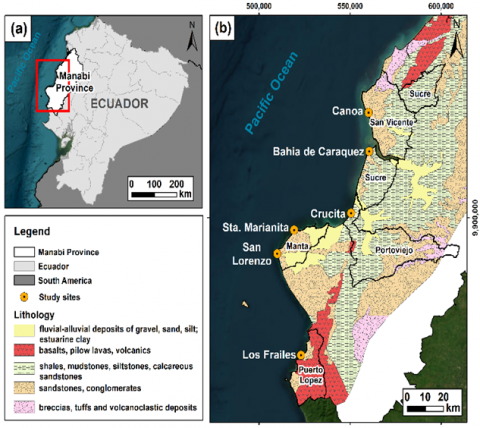
Figure 1. The study area map. a) General location in Ecuador, b) Location of coastal study sites and associated lithology
Source: Adapted from [18]
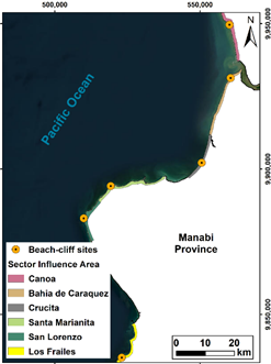
The study area includes the beach-cliff systems of Canoa, Bahia de Caraquez, Crucita, Santa Marianita, San Lorenzo and Los Frailes, located along the coastline of the province of Manabi, Ecuador, in the cantons of Sucre, San Vicente, Portoviejo, Manta and Puerto Lopez, respectively (Figure 1a, b). These beach-cliff systems are the most representative of Manabi due to their geomorphology of tens of meters high and long rectilinear beaches [24], which constitute an important tourist attraction and promote the development of the surrounding communities that benefit economically from tourism of sun and beach [25]. In the study cantons, the population reaches 713,870 inhabitants, of which around 172,598 belong to the rural population [26] and are mainly engaged in fishing activities and commerce.
The geological context is varied, recognising five lithological units: (i) basalts, pillow lavas and volcanics of the Piñon and Cayo Formations (Cretaceous); (ii) sandstones and conglomerates of the Angostura, Borbon and San Mateo Formations (Miocene, Pliocene, Eocene); (iii) shales, mudstones, siltstones and calcareous sandstones of the Dos Bocas, Villingota and Onzole Formations (Miocene); (iv) breccias, tuffs and volcanoclastic deposits of the upper member of the Borbon Formation (Pleistocene), and fluvial-alluvial deposits (gravel, sand, silt) and estuarine clays of the Quaternary (Pleistocene) (Figure 1b) [18].
The study area presents a seismic history related to the subduction zone. In the past, large-magnitude earthquakes occurred, causing landslides, cracks and terrain uplifts in Canoa, Portoviejo and Bahia de Caraquez, such as those of 1896 and 1998 [19, 20]. The most recent earthquake (2016), in addition to geomorphological changes (with landslides in cliff areas and coastal upheavals mainly in Crucita and Pedernales) [27], caused 663 deaths and 6,274 injured [28], damage to infrastructure valued at millions of dollars, and impacts at a social and tourist level.
The methodology of this study had three phases: i) compilation of satellite images and delimitation of the study area, ii) multitemporal geomorphological analysis and iii) analysis of Strengths, Weaknesses, Opportunities and Threats (SWOT) and strategies proposal (Figure 2).
Figure 2. Methodological scheme of the study
3.1 Phase I: Satellite images and study area
Phase I consisted of collecting satellite images from the Google Earth platform, before and after the 2016 earthquake, for the six beach-cliff systems of the study to visualise the terrain's evolution and verify geomorphological changes in this part of the coast.
In addition, the study contemplated the creation of analysis sections for each beach-cliff system, taking into account an area of influence of 1 km from the coastline, considered the area subject to constant coastal dynamics.
3.2 Phase II: Multitemporal geomorphological analysis
This stage included recognising the main geomorphological elements in the areas of interest (beach-cliff systems) before and after the 2016 earthquake.
For this, the study first considered the elaboration of slope models of the study sections elaborated from the Manabi provincial Digital Terrain Model (DTM), obtained from the Ecuadorian Military Geographic Institute (IGM) free access platform. The digital slope models were classified into five slope units detailed in Table 1.
Table 1. Degree of slope and categorization
|
Slope (°) |
Categorization |
|
<10 |
Low |
|
<30 |
Medium |
|
<50 |
Medium-High |
|
<70 |
High |
|
>70 |
Very High |
Subsequently, using a Geographic Information System, the main geomorphological elements were identified and delimited on the images collected from the study sections of the beach-cliff systems, both in the orthophotos before and after the earthquake.
The identification and delimitation of the different geomorphological elements considered the values obtained from the slope model (degree of slope) and other features observed in the photointerpretation of the satellite images and their three-dimensional visualisation on the Google Earth platform, such as vegetation development, concave or convex lines in the cliffs and strong topographic changes.
The recognised elements were grouped according to genetic criteria such as forms of coastal, gravity and fluvial dynamics.
This phase also considered calculating the cliffs' retreat rates, measuring between delimited cliff edges before and after the 2016 earthquake in images with four years gap, using the ArcMap software's "measure" tool.
3.3 Phase III: SWOT analysis and strategies proposal
Phase III used the DELPHI technique to analyse Strengths, Weaknesses, Opportunities and Threats for the six beach-cliff systems. To this end, a focus group was formed made up of five researchers specialised in the areas of geomorphology and geotourism, who, based on field observations and the results of the multitemporal geomorphological analysis in the study sectors, issued their criteria and formulated strategies aimed at managing coastal sites for the promotion of local tourism.
The analysis was carried out through a series of three rounds. In the first round, the main findings of the study were presented; in the second round, the strengths, weaknesses, opportunities and threats were identified; and in the third round, the strategic proposal was made through the Strengths-Opportunities, Weaknesses-Opportunities, Strengths-Threats, and Weaknesses-Threats relationships.
4.1 Phase I: Image collection and study area delimitation
4.1.1 Satellite images
The images before and after the 2016 earthquake come from the Google Earth platform, selected according to the temporal availability and visualization quality (low cloudiness and sharpness). Table 2 shows the detail of the date of the images selected for each sector of the study.
Table 2. Detail of the date of images selected for the study in each sector
|
Sector |
Year of Image Pre-Earthquake |
Year of Image Post-Earthquake |
|
Canoa |
2014 |
2016 |
|
Bahia de Caraquez |
2014 |
2016 |
|
Crucita |
2015 |
2016 |
|
Santa Marianita |
2014 |
2016 |
|
San Lorenzo |
2014 |
2017 |
|
Los Frailes |
2013 |
2017 |
4.1.2 Study area
The study area was limited to a place of influence of 1 km from the coastline in each beach-cliff sector (Figure 3) by applying the “buffer” function of the ArcMap software.
Figure 3. Delimitation of the study area to an area of influence of 1 km from the coastline
4.2 Phase II: Comparative geomorphological analysis
4.2.1 Slope models
The slope models obtained for each study section (Figure 4) allowed the differentiation of the different geomorphological elements associated with the slope value ranges, as shown in Table 3. Likewise, those abrupt zones (>50°), with a greater probability of instability or possibility of slippage.
Table 3. Associated geomorphological elements based on the range of slope values
|
Slope (°) |
Geomorphological Element Associated |
|
0-10 |
Abrasion platform |
|
30-50 |
Balanced slope |
|
50-70 |
Active cliff |
Figure 4. Slope models for the study sectors
The geomorphological elements were identified and delimited for all the study sectors in the pre- and post-earthquake images, generally identifying forms of coastal, gravity and fluvial dynamics of an erosive and depositional nature as shown in Table 4.
Table 4. Geomorphological elements identified in the study areas
|
Identified Landform |
Geomorphological Element |
|
|
Coastal Dynamic |
Erosive |
Abrasion platform |
|
Active cliff |
||
|
Sea stump |
||
|
Depositional |
Cracks |
|
|
Gravity |
Erosive |
Scars |
|
Balanced slope |
||
|
Surface debris flow |
||
|
Depositional |
Complex slope movement |
|
|
Fluvial |
Erosive |
Fluvial basin |
4.2.2 Evolution of study areas
The Canoa sector's geomorphology showed active cliffs, superficial debris flows, balanced slopes, abrasion platforms, cracks and scars. The comparison of the images before and after the seism allowed us to observe the increase in the surface of the superficial debris flows associated with the weakening of the slopes of the active cliff and the hillsides (Figure 5).
Figure 5. Geomorphological analysis Canoa sector 2014 vs 2016
The geomorphological elements in the Bahia de Caraquez sector include active cliffs, complex slope movements, superficial debris flows, balanced slopes, cracks, scars, and a fluvial basin. The evolutionary analysis of the area allowed us to observe the development of extensive superficial debris flows in the part of the active cliffs, as well as complex slope movements, cracks and scars on the southern side of the river basin (Figure 6).
Figure 6. Geomorphological analysis Bahia de Caraquez sector 2014 vs 2016
The Crucita sector evidenced a system that groups active cliffs, superficial debris flows, complex slope movements, cracks and scars. After the earthquake, the terrain shows an increase in complex slope movements, causing large superficial debris flows that appear to cover the cliff walls and the development of new cracks. A significant increase in the abrasion platform was also appreciated in this area, indicating its uplift due to the earthquake (Figure 7).
Figure 7. Geomorphological analysis Crucita sector 2015 vs 2016
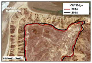
The Santa Marianita sector is the only one that exhibits all the geomorphological elements of Table 4. In comparing both years, there was little variation in the extension of the identified features, except for the superficial debris flows, which appear larger in the post-event image, indicating the weakening of the hillside near this area. Another important characteristic of the sector is that the abrasion platform presents a minor outcrop associated with a possible increase in the coastline due to the waves (Figure 8).
Figure 8. Geomorphological analysis Santa Marianita sector 2014 vs 2016
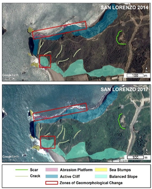
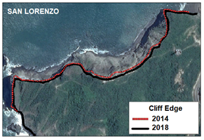
The San Lorenzo beach-cliff system is one of the simplest, presenting a stretch of an active cliff to the north and balanced slopes to the south. In the evolution of this part of the coast, the most noticeable change was the increase in the balanced slope. In addition, the abrasion platform's greater outcropping surface relates to the coastline's retreat (Figure 9).
Figure 9. Geomorphological analysis San Lorenzo sector 2014 vs 2017
The Los Frailes sector comprises two cape landforms, joined by an extensive bay. In the place, abrasion platforms, active cliffs, superficial debris flows and balanced slopes were identified. After the 2016 seismic event, there was a development of complex movement zones near the active cliffs, as well as new cracks in the southern part. In addition to the increase in the extent of superficial debris flows (Figure 10).
Figure 10. Geomorphological analysis Los Frailes sector 2013 vs 2017
4.2.3 Cliff retreat rate
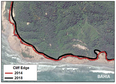
For calculating the retreat rates of the cliffs, four-year periods between the images after and before the seismic event was taken into account to carry out analysis over a longer and more equitable period for all the cliffs. Figures 11-16 show the change in the cliff's edge for each study sector in the considered period.
Table 5 summarizes the six beach-cliff systems' minimum, and maximum distances retreated and retreat rates. Crucita has the highest retreat rate (1 m/year), while Santa Marianita has the lowest (0.53 m/year).
Table 5. Cliff retreat: Minimum and maximum distance and retreat rates for each sector of the study
|
Sector |
Minimum Retreat Distance (m) |
Maximum Retreat Distance (m) |
Retreat Rate (m/year) |
|
Canoa |
1.3 |
3.05 |
0.76 |
|
Bahia de Caraquez |
1.15 |
3.55 |
0.89 |
|
Crucita |
1.88 |
4 |
1 |
|
Santa Marianita |
1.24 |
2.10 |
0.53 |
|
San Lorenzo |
2.88 |
3.33 |
0.83 |
|
Los Frailes |
0.89 |
2.48 |
0.62 |
Figure 11. Canoa cliff limit comparison (2014-2018)
Figure 12. Bahia de Caraquez cliff limit comparison (2014-2018)
Figure 13. Crucita cliff limit comparison (2013-2017)
Figure 14. Santa Marianita cliff limit comparison (2014-2018)
Figure 15. San Lorenzo cliff limit comparison (2014-2018)
Figure 16. Los Frailes cliff limit comparison (2013-2017)
4.3 Phase III: SWOT analysis and strategic approach
Through three rounds of analysis, the beach-cliff systems’ strengths, weaknesses, opportunities, and threats were uncovered, ultimately creating a strategic proposal.
Figure 17 summarizes the SWOT analysis for the set of sectors considered in the study. The analysis revealed that the beach-cliff systems have weaknesses related to their exposure to natural phenomena and the lack of conservation plans and signage for adequate tourism, which are increased by threats such as the lack of tourism development projects and weather events. However, due to their strengths linked to the landscape and geomorphological resources with good accessibility, they are considerable places for continuous tourist use, which can be improved by taking advantage of project development opportunities, government and community participation, and tourism promotion.
Figure 17. SWOT analysis for the study sites
Figure 18. Proposal of management strategies for the study sites
The SWOT analysis allowed the configuration of various strategies to improve the management of the beach-cliff systems in the study. The strategies were proposed based on the Strengths-Opportunities, Weaknesses-Opportunities, Strengths-Threats, and Weaknesses-Threats. This work suggests a comprehensive management model focused on the political, academic-scientific, social and tourist aspects to achieve their protection as natural landforms and, in turn, promote responsible and safe tourism in each sector (Figure 18). For its effective development, articulating inter-institutional and interdisciplinary working groups with the participation of local governments, higher education institutions, the community and public-private sector companies is essential.
The process of developing the strategies in terms of the axes mentioned is detailed below:
-Politics: There is delivery to local governments of these results and the documentation generated for their management.
-Scientific-Academic: Motivate the development of undergraduate and postgraduate works that contribute to the knowledge of the processes that influence the study sectors at a technical, social and environmental level and serve as an input in decision-making for the benefit of the habitants.
-Social: Carry out socialization and training workshops with participatory methods so the community knows the information and can use it in its development process.
-Touristic: Highlight the value of the landscape with the risks that must be considered. Four of the six sites (San Lorenzo, Santa Marianita, Los Frailes and Crucita) are catalogued in the tourism inventory of Ecuador, and the rest have a similar tourism potential, which is why their inclusion is encouraged in the future.
This paper presents the geomorphological characteristics associated with six Manabi beach-cliff systems, considering the changes in relief as a result of seismic events of significant magnitude. The results express a constant marine-coastal dynamic, reflected in the receding of the cliffs, which in turn is enhanced by eventual geological phenomena such as seismic events. The estimated minimum setback distance was 0.89 m (Los Frailes), and the maximum was 4 m (Crucita).
The geomorphological analysis made it possible to identify the influence of coastal, gravitational and fluvial dynamics in the modelling of the coastal terrain and also to show local geomorphological modifications in the study sectors, attributed to the 2016 earthquake, mainly in the Bahia de Caraquez and Crucita sectors, which they presented the most notorious changes, with the increase in superficial debris flows, complex slope movements and cracking of the terrain; and in the case of Crucita, the lifting of the abrasion platform.
On the other hand, these coastal sites have a scenic charm linked to the geomorphology of the place, which makes its beaches and cliffs sites for tourism and recreation. However, they are natural attractions that need infrastructure that allows adequate tourism in the area and that, at the same time, supports the entrepreneurship of the local population for these purposes. In addition, they constitute sites with the potential for geological education regarding active coastal and tectonic geoprocesses and the development of risk reduction programs and conservation studies, which need consideration.
The earthquake that occurred in 2016 caused sequelae that impacted various aspects of the province, affecting the social, labour, tourist and economic outlook [29, 30], for which the analysis of this work seeks to provide a possible solution to social demands of the sector, adapting to coastal dynamics and making use of local representative geological resources, fostered through comprehensive strategies that combine political, academic, social and tourist participation.
The empowerment of these places, which stand out for their landscaping and diverse geomorphological characteristics, is key to local development strategies [31]. Coastal sites with features of this type make use of their benefits and resources through trending proposals such as geological tourism (geotourism) and geological education (geoeducation), such as the case of the Anconcito cliff in Santa Elena (Ecuador) included in a tourist route [32], and the case of the cliffs of São Paulo presented as geomorphosites [33]. In this way, similar initiatives can be favourable for improving the tourist proposal in the context of sustainability.
This work allowed knowing the influence of seismic events in the geomorphological modelling of six beach-cliff systems on the central coast of Manabi. The Crucita and Bahia de Caraquez sites show the highest retreat rates, with values of 1 and 0.89 m/year, respectively, and in the Santa Marianita and Los Frailes sites, there is a slower retreat rate, with values of 0.53 and 0.62 m/year. This analysis allows the configuration of strategies aimed at coastal management and strengthening tourist activity with acceptable levels of security in the area, thus building an alternative solution to the socio-economic impacts after the earthquake. The geomorphological analysis showed that erosive, gravitational and fluvial processes predominate in the study sectors, which give rise to various geomorphological elements, but which, in turn, are enhanced by seismic events, such as the 2016 earthquake, which promote strong changes, mainly associated with mass movements and upheavals of the terrain. The SWOT analysis allowed the configuration of strategies to improve the tourist use and conservation of these coastal landforms.
This work represents a basis for territorial planning, with possibilities of use by local governments and decision-makers to establish coastal management policies. In addition, it opens the way for future research with periodic data and in situ mapping.
Among the study's limitations is using satellite images, comparing only two dates, one before and one after the earthquake, therefore, a multitemporal analysis is recommended more frequently to detect other possible affectations or considerations. Future lines can contemplate elaborating vulnerability maps to erosion, anthropic, and seismic activity. These vulnerability maps can help build an early warning system in risk prevention.
The research was funded by ESPOL. The following project support this work: Registro del Patrimonio Geológico y Minero y su incidencia en la defensa y preservación de la geodiversidad en Ecuador (Registry of Geological and Mining Heritage and its impact on the defense and preservation of geodiversity in Ecuador), with code No. CIPAT-01-2018. Also, the authors would like to thank the Centro de Investigación y Proyectos Aplicados a las Ciencias de la Tierra (CIPAT), Universidad de Oviedo (UO), Instituto Geológico y Minero de España (IGME) for the support given in the development of the present scientific work.
[1] Yang, F., Zhang, L., Chen, B., Li, K., Liao, J., Mahmood, R., Hasan, M.E., Al Mamun, M.M.A., Raza, S.A., Sutrisno, D. (2023). Long-term change of coastline length along selected coastal countries of Eurasia and African continents. Remote Sensing, 15(9): 2344. https://doi.org/10.3390/rs15092344
[2] Trenhaile, A.S. (1987). The Geomorphology of Rock Coasts. Oxford University Press. https://doi.org/10.1177/030913338801200215
[3] Guitián, M.A.R., Real, C., Ramil-Rego, P., Franco, R.R., Castro, H.L. (2020). Characteristics, vulnerability and conservation value of active tufa-forming springs on coastal cliffs in the NW Iberian Peninsula. Ocean & Coastal Management, 189: 105122. https://doi.org/10.1016/j.ocecoaman.2020.105122
[4] Bird, E. (2016). Coastal Cliffs: Morphology and Management. Springer International Publishing.
[5] Orchard, S., Hughey, K.F., Measures, R., Schiel, D.R. (2020). Coastal tectonics and habitat squeeze: Response of a tidal lagoon to co-seismic sea-level change. Natural Hazards, 103: 3609-3631. https://doi.org/10.1007/s11069-020-04147-w
[6] Gravel-Miguel, C., De Vynck, J., Wren, C.D., Murray, J.K., Marean, C.W. (2022). Were prehistoric coastal sites more intensively occupied than inland sites? Using an agent-based model to understand the intensity of prehistoric coastal occupation, and what it means for studies on the evolution of the coastal adaptation. Quaternary International, 638: 148-158. https://doi.org/10.1016/j.quaint.2022.02.003
[7] Normand, R., Simpson, G., Bahroudi, A. (2019). Pleistocene coastal evolution in the Makran subduction zone. Frontiers in Earth Science, 7: 186. https://doi.org/10.3389/feart.2019.00186
[8] Li, C., Wang, M., Liu, K., Coulthard, T.J. (2020). Landscape evolution of the Wenchuan earthquake-stricken area in response to future climate change. Journal of Hydrology, 590: 125244. https://doi.org/10.1016/j.jhydrol.2020.125244
[9] Huang, H., Ju, S., Duan, W., Jiang, D., Gao, Z., Liu, H. (2023). Landslide monitoring along the Dadu River in Sichuan based on Sentinel-1 multi-temporal InSAR. Sensors, 23(7): 3383. https://doi.org/10.3390/s23073383
[10] Grant, A.R., Struble, W.T., LaHusen, S.R. (2022). Limits to coseismic landslides triggered by Cascadia Subduction Zone earthquakes. Geomorphology, 418: 108477. https://doi.org/10.1016/j.geomorph.2022.108477
[11] Carrión-Mero, P., Briones-Bitar, J., Morante-Carballo, F., Stay-Coello, D., Blanco-Torrens, R., Berrezueta, E. (2021). Evaluation of slope stability in an urban area as a basis for territorial planning: A case study. Applied Sciences, 11(11): 5013. https://doi.org/10.3390/app11115013
[12] Morante, F., Aguilar, M., Ramírez, G., Blanco, R., Carrión, P., Briones, J., Berrezueta, E. (2019). Evaluation of slope stability considering the preservation of the general patrimonial cemetery of Guayaquil, Ecuador. Geosciences, 9(3): 103. https://doi.org/10.3390/geosciences9030103
[13] Castilla, J.C. (1988). Earthquake-caused coastal uplift and its effects on rocky intertidal kelp communities. Science, 242(4877): 440-443. https://doi.org/10.1126/science.242.4877.440
[14] Kitamura, A., Ina, T., Suzuki, D., Tsutahara, K., Sugawara, D., Yamada, K., Aoshima, A. (2019). Geologic evidence for coseismic uplift at~ AD 400 in coastal lowland deposits on the Shimizu Plain, central Japan. Progress in Earth and Planetary Science, 6(1): 1-15. https://doi.org/10.1186/s40645-019-0305-y
[15] Vargas, G., Farías, M., Carretier, S., Tassara, A., Baize, S., Melnick, D. (2011). Coastal uplift and tsunami effects associated to the 2010 Mw8. 8 Maule earthquake in Central Chile. Andean Geology, 38(1): 219-238.
[16] Lynner, C., Koch, C., Beck, S.L., et al. (2020). Upper-plate structure in Ecuador coincident with the subduction of the Carnegie Ridge and the southern extent of large mega-thrust earthquakes. Geophysical Journal International, 220(3): 1965-1977. https://doi.org/10.1093/gji/ggz558
[17] Tamay, J., Galindo-Zaldívar, J., Martos, Y.M., Soto, J. (2018). Gravity and magnetic anomalies of ecuadorian margin: Implications in the deep structure of the subduction of Nazca Plate and Andes Cordillera. Journal of South American Earth Sciences, 85: 68-80. https://doi.org/10.1016/j.jsames.2018.04.020
[18] Chunga, K., Livio, F.A., Martillo, C., Lara-Saavedra, H., Ferrario, M.F., Zevallos, I., Michetti, A.M. (2019). Landslides triggered by the 2016 Mw 7.8 Pedernales, Ecuador earthquake: Correlations with ESI-07 intensity, lithology, slope and PGA-h. Geosciences, 9(9): 371. https://doi.org/10.3390/geosciences9090371
[19] Beauval, C., Yepes, H., Palacios, P., et al. (2013). An earthquake catalog for seismic hazard assessment in Ecuador. Bulletin of the Seismological Society of America, 103(2A): 773-786. https://doi.org/10.1785/0120120270
[20] Egred, J. (2009). Catálogo de terremotos del Ecuador. Instituto Geofísico/Escuela Politécnica Nacional, Quito, Ecuador.
[21] Ye, L., Kanamori, H., Avouac, J.P., Li, L., Cheung, K.F., Lay, T. (2016). The 16 April 2016, MW 7.8 (MS 7.5) Ecuador earthquake: A quasi-repeat of the 1942 MS 7.5 earthquake and partial re-rupture of the 1906 MS 8.6 Colombia–Ecuador earthquake. Earth and Planetary Science Letters, 454: 248-258. https://doi.org/10.1016/j.epsl.2016.09.006
[22] Furtado, A., Rodrigues, H., Arêde, A., Varum, H. (2021). A review of the performance of infilled RC structures in recent earthquakes. Applied Sciences, 11(13): 5889. https://doi.org/10.3390/app11135889
[23] Nath, A., Koley, B., Choudhury, T., Saraswati, S., Ray, B.C., Um, J.S., Sharma, A. (2023). Assessing coastal land-use and land-cover change dynamics using geospatial techniques. Sustainability, 15(9): 7398. https://doi.org/10.3390/su15097398
[24] Winckell, A. (1982). Relieve y geomorfología del Ecuador. Documentos de investigacion, Centro ecuatoriano de investigacion geografica Guayaquil, 1: 3-19. http://pascal-francis.inist.fr/vibad/index.php?action=getRecordDetail&idt=12451924.
[25] Rodolfo, M.D.E., Del Rosario, D.O.M., Antonio, L.S.J. (2021). Are there opportunities for sustainable tourism in the province of Manabí - Ecuador after COVID-19? The case study of Puerto Lopez. International Journal of Sustainable Development and Planning, 16: 1415-1423. https://doi.org/10.18280/ijsdp.160802
[26] INEC. (2021). Proyección poblacional a nivel cantonal periodo 2020-2025. Sistema Nacional de Información. https://sni.gob.ec/proyecciones-y-estudios-demograficos.
[27] Chunga, K., Livio, F., Mulas, M., Ochoa‐Cornejo, F., Besenzon, D., Ferrario, M.F., Michetti, A.M. (2018). Earthquake ground effects and intensity of the 16 April 2016 Mw 7.8 Pedernales, Ecuador, earthquake: Implications for the source characterization of large subduction earthquakes. Bulletin of the Seismological Society of America, 108(6): 3384-3397. https://doi.org/10.1785/0120180051
[28] Troya, M.I., Greene, M.C., Santos, C.G., Shultz, J.M. (2016). Conducting a desk review to inform the mental health and psychosocial support response to the 2016 Ecuador earthquake. Disaster Health, 3(4): 90-101. https://doi.org/10.1080/21665044.2016.1261598
[29] Félix Mendoza, Á.G., Mateos, M.R., Reinoso, N.G. (2021). Perception and rating of tourism entrepreneurs in the recovery of travel destinations affected by social-natural disasters: Case study from the April 16th earthquake in Ecuador. International Journal of Disaster Risk Reduction, 64: 102488. https://doi.org/10.1016/j.ijdrr.2021.102488
[30] Guerrero-Miranda, P., Luque González, A. (2021). Social responsibility, sustainability, and public policy: The lessons of debris management after the Manabí Earthquake in Ecuador. International Journal of Environmental Research and Public Health, 18(7): 3494. https://doi.org/10.3390/ijerph18073494
[31] Carrión-Mero, P., Ayala-Granda, A., Serrano-Ayala, S., Morante-Carballo, F., Aguilar-Aguilar, M., Gurumendi-Noriega, M., Paz-Salas, N., Herrera-Franco, G., Berrezueta, E. (2020). Assessment of geomorphosites for geotourism in the northern part of the “Ruta Escondida” (Quito, Ecuador). Sustainability, 12(20): 8468. https://doi.org/10.3390/su12208468
[32] Herrera-Franco, G., Mora-Frank, C., Kovács, T., Berrezueta, E. (2022). Georoutes as a basis for territorial development of the Pacific Coast of South America: A case study. Geoheritage, 14(3): 78. https://doi.org/10.1007/s12371-022-00711-x
[33] Mazzucato, E., de La Corte Bacci, D., de Gouveia Souza, C.R. (2022). Geomorphological heritage on the North Coast of the State of São Paulo: A perspective about current and past climate changes. Geoheritage, 14(4): 121. https://doi.org/10.1007/s12371-022-00756-y