Basim Thair Mitab*![]() | Rana Mozahim Hamdoon
| Rana Mozahim Hamdoon![]() | Khamis Naba Sayl
| Khamis Naba Sayl![]()
© 2023 IIETA. This article is published by IIETA and is licensed under the CC BY 4.0 license (http://creativecommons.org/licenses/by/4.0/).
OPEN ACCESS
Solid waste management poses a significant challenge in rapidly growing urban centers in developing countries, including Iraq. Landfilling is the most prevalent method for solid waste disposal, and identifying suitable landfill locations that minimize environmental and societal impacts is crucial. The proliferation of random waste disposal sites in Kirkuk city underscores the need for the application of international standards in selecting optimal landfill sites. In this study, Geographic Information System (GIS) and Analytical Hierarchy Process (AHP) were integrated to determine the most appropriate landfill site in Kirkuk city. A model was developed to identify the most suitable location for a proposed landfill, taking into account various factors. Four potential sites were proposed and compared to the existing location, with the selection based on multiple criteria. Key criteria included proximity to villages, wells, rivers, surface water, hospitals, schools, oil pipelines, airports, and parks; environmental factors such as agricultural land, hydrology, groundwater, and land use/land cover (LULC); engineering aspects including soil, roads, slopes, railways, and valleys; and socio-economic factors like cost and public acceptance. The results indicated that the current landfill site exhibited the least negative impact on environmental, economic, and social aspects. The proposed method demonstrated efficiency in application, reducing the time and cost with remarkable accuracy.
geographical information system (GIS), Iraq, landfill, waste
The process of landfill site selection is a complex task in waste management, as it entails a combination of social, environmental, and technical factors [1, 2]. Solid waste is generally classified into three main categories, each managed by different government agencies: hazardous waste, which includes infectious waste, sharp tools, chemicals, pharmaceuticals, and radioactive waste, falls under environmental management; medical waste, generated by medical or veterinary facilities, is overseen by the Ministry of Health; and municipal solid waste (non-hazardous), comprising residential, commercial, institutional, industrial, and public waste, is supervised by the Ministry of Housing. Identifying landfill locations is a challenging endeavor for planners and authorities due to numerous factors, such as population growth, increased environmental awareness, limited land availability for landfills, government regulations, municipal financing, and urbanization [3].
Waste management can be succinctly defined as an integrated process associated with the main elements that must be controlled, including waste generation, storage, collection, transportation, treatment, and disposal. Integrated solid waste management involves selecting and implementing appropriate waste management technologies and programs to achieve specific goals and objectives. Conducting a proper environmental assessment requires determining the actual needs (demand) of the area. Quantifying solid waste generated in Kirkuk is essential for developing an effective solid waste management plan. At the feasibility study level, waste quantity can influence the preference of one alternative over another. At the design level, the amount of waste generated affects the volume and cost of design alternatives. In the solid waste management sector, demand volume is primarily based on the solid waste generation rate. The composition of generated waste is another critical factor influencing the waste management plan, as resource recovery and recycling options can change significantly.
The process of selecting optimal landfill locations depends on one or more social, environmental, economic, and engineering factors. This procedure demands significant effort and time due to the multitude of factors influencing location cost determination. Previous experiences in landfill planning and construction have demonstrated that weak and imperfect planning can lead to increased costs and other issues [4, 5]. Traditional methods are characterized by reduced accuracy, long duration, and difficulties that arise when making location changes and considering all relevant features. Therefore, it is imperative to implement new approaches that aid in taking into account the consequence of each factor and relating them to each other. Geographic Information Systems (GIS) serve as one of the most significant tools, functioning both as a collection and analysis tool for diverse geographic information simultaneously.
Several prior studies have addressed landfill planning, specifically using GIS-based multi-criteria analysis [5-14]. The resulting combination of these methods enhances the effectiveness and quality of spatial analysis. However, not all criteria were considered in the process of selecting optimal locations in these studies, as some were limited to environmental, economic, proximity, or social aspects. In the present study, all these criteria were combined to produce the spatial suitability of the landfill. To resolve the problem of landfill site location, the integration of Geographic Information Systems (GIS) and the Analytical Hierarchy Process (AHP) was employed. AHP is one of the most common methods for multi-criteria decision-making due to its theoretical basis and high ability to solve complex problems during the selection process in various fields [3, 15-23]. AHP is used to determine the consistency of weighting criteria.
The main objective of this study is to select the most appropriate candidate sites for landfill in Kirkuk, Iraq, which meet environmental and scientific criteria. This study aims to establish the foundations for proper planning of sanitary waste dumps and suggest specific places as suitable sites for waste dump establishment based on a set of conditions and criteria. Researchers have emphasized the limited data used for landfill sites while employing conventional methods. These methods are generally time-consuming, costly, and limited in their ability to retrieve temporal and spatial variability, particularly in large-scale areas. The literature gap is that previous researchers considered engineering, environmental, and proximity criteria, while models addressing social criteria remain scarce. Therefore, this study fills the literature gaps by considering engineering, environmental, proximity, and socio-economic criteria. To achieve this goal, several steps are required: (1) Divide the area of each standard map into categories to suit the requirements and assign an appropriate weighting to each category. (2) Determine the final map of landfill sites using GIS analysis tools, excluding areas unsuitable for landfill sites. These outcomes successfully fulfill the objectives set out in this study, including identification of suitable criteria, estimation of their respective weights, determination of appropriate and unsuitable areas for sanitary landfills based on four key criteria, and comparison of these results with suggested landfill sites. Ultimately, this study identifies suitable sites for establishing landfill projects in the study region.
Kirkuk city is situated in the Khassa chia river, which is passing through the city and bifurcates it into Eastern and Western Kirkuk , as shown in Figure (1). The city position is located on the latitude of “35° 28' 5"” north and longitude of “44° 23' 31"” east, and almost at “350m” over the sea level based on the Universal Transverse Mercator System “UTMS”. It includes 13 administrative units forming four districts, Kirkuk district region has an area of 797km2 of the area is 797km square. In 2010, the people of Kirkuk city were estimated to be 1,475,711 people.
Kirkuk lies between the Zagros Mountains (northeast), the Zab and Tigris rivers (west), the Hamrin Mountains (south), and Sirwan, the Diyala River (southeast).
The topography of Kirkuk is generally very flat with a similar topography in the north, which is 786km from the Arabian Gulf. The northeastern highlands start south of Kirkuk and extend towards the Iraqi borders with Iran and Turkey.
Figure 1. Study area
3.1 Data sources and modeling procedure
-An aerial photograph of Kirkuk Governorate for the year 2019 with a resolution of (5m*5m), obtained from the Urban Planning Department, showing the proposed landfill sites.
-The DEM image for the year 2021 was downloaded with a resolution of (12.5m*12.5m) from the USGS, through which a slope map of the study area is generated.
-A geological map at a scale of 1:750,000 obtained from the Iraqi Geological Survey, and used to digitize the geological formations of the study area.
-Sentinel 2 satellite image with spatial resolution (10x10m) Obtained in November 2021 from the USGS.
-In ArcGIS 10.8, using the UTM-WGS84 projection of zone 38 N, a database of all parameters and digitization and necessary analyzes was created to produce a spatial adequacy map.
3.2 Method
In this research, the GIS program and the AHP method, which is one of the most common MCDA methods, were used to manage the process of selecting the appropriate landfill site in Kirkuk city as shown in Figure 2. This procedure includes several steps that were performed using ESRI's ArcGIS 10.8 spatial analyzer. The following steps will be explained in detail:
Figure 2. Flowchart for proposed method
Five sites were proposed to be a landfill for waste in the city of Kirkuk, and this proposal came after discussion with the relevant authorities, which are the Municipality of Kirkuk, the Department of Urban Planning, and the Environment of Kirkuk, in order to reduce the impact of these sites on human health and the environment. The five sites are shown in the (Figure 3, Table 1) and they are:
A1: It is located in the Zindaneh sector in Kirkuk Governorate, 10km south of the city of Kirkuk, between Taza and Laylan. Its area is about 70 hectares.
A2: It is located between Laylan district and Daquq district in Kirkuk Governorate, 18km south of Kirkuk city, its area is 48 hectares.
A3: It is located between the Al-Hawija district and the Riyadh district in Kirkuk Governorate, 17km southwest of the city of Kirkuk, with an area of 90 hectares.
A4: It is located between Al-Dibs district and Al-Hawija district in Kirkuk governorate, 12km west of Kirkuk city, its area is 66 hectares.
A5: It is located between Al-Dibs and Al-Hawija districts in Kirkuk Governorate, 11km west of Kirkuk, with an area of 67 hectares.
Table 1. The proposed landfill coordinates
|
sites |
X-coordinates |
Y-coordinates |
|
A1 |
442867 |
3906784 |
|
A2 |
466424 |
3905861 |
|
A3 |
403807 |
3929714 |
|
A4 |
414101 |
3941345 |
|
A5 |
424894 |
3942193 |
Figure 3. Proposed landfill sites
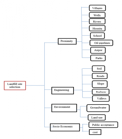
At this stage, the appropriate criteria are determined for choosing the ideal landfill sites. The criteria were determined based on previous studies such as [5, 8, 24-26], where there were several criteria. A database has been developed for each of the criteria used. The standards have been classified into four main groups, namely: the proximity standard includes human settlements, major rivers, parks, wells, airports, hospitals, schools, and oil pipelines, the engineering standard includes soil type, roads, slopes, railways, and valleys, the environmental standard includes groundwater, land uses, finally, the social criterion that includes general acceptance and cost, as shown in Figure 4, where these criteria will be explained in detail:
Figure 4. Hierarchy of the selected criteria for landfill site selection
5.1 Proximity criteria
This criterion aims to minimize the possibility of settling a waste landfill near any facility related to humanity, to reduce potential negative impacts [27, 28]. The most relevant matters in the assessment are represented by a set of genuinely necessary criteria including:
5.1.1 Distance to villages
The importance of residential areas must be taken into account before starting a project to implement landfill sites. According to studies [29, 30], areas located at distances of less than 5000m are less suitable, while areas of more than 5000m are more appropriate. This is a result of preserving the aesthetics of residential areas and preventing air pollution and other health phenomena. This leads to the spread and spread of diseases within the residential areas close to the dump site. Therefore, landfill sites must be far from humans to avoid potential negative effects. In this study, the residential settlements layer was created based on the distance not less than 5000m from settlements using the 2019 aerial photograph of Kirkuk Governorate.
5.1.2 Distance to wells
Landfill sites have severe environmental impacts not only on the earth's surface, but also on underground resources, including wells. This effect occurs through the leakage of the landfill juice and its permeation into the groundwater, causing pollution in it, especially if the water depths are close to the surface. Therefore, the landfill sites must be far from groundwater sources and wells far from groundwater sources and wells. According to study [8], distances less than 400 meters are not suitable, and distances greater than 800 meters are the most suitable areas. The well layer was obtained from the Water Resources Department in Kirkuk.
5.1.3 Distance to oil pipes
Considering that the study area is rich in oil, a buffer zone must be defined between the landfill site and the oil pipelines. The buffer zone required for oil pipelines has been determined to be 75m on both sides [31], which is considered a safe distance to the landfill site, according to the specifications of the Iraqi Ministry of Oil/oil pipelines Company, 1989 (Iraqi Ministry of Oil, 2015). The oil pipeline layer was obtained from the North Oil Company.
5.1.4 Distance to airports
The purpose of this standard is to reduce the indiscriminate collision of birds with aircraft during take-off or landing at airports to the lowest possible extent, unless there are procedures approved by the site manager to control birds. The safe distances between airports and waste burial sites have been determined as 3000m [32]. The airports layer was drawn through the 2019 aerial image of Kirkuk Governorate with the GIS program.
5.1.5 Distance to rivers
Landfills pose a potential threat to the surface water resources of rivers, ponds, lakes, etc. through leachate movement and waste erosion. It is always better to locate landfills away from water bodies. Opinions differed regarding the buffer zone between the landfill site and the rivers, where Dörhöfer and Siebert [33] considered distances of more than 500m considered safe for building a landfill, while the Iranian Water Resources Management Company (2013) they proved that landfills should be established at least 750m away from sources Surface water. A distance of 1000m was adopted from the river borders, and a value of 0 was given for distances less than 1000m and a value of 1 for distances more than 1000m. The rivers layer was drawn through the aerial image of Kirkuk 2019 in the GIS program.
5.1.6 Distance to hospitals
Hospitals are considered places with a crowded population, and they must be far from all sources of pollution that may be caused by landfill sites. The buffer zone between hospitals and landfill sites is 3000m, where a value of 0 is given for distances less than 3000m, and a value of 1 for distances more than 3000m [34]. The criterion was represented by making use of a land use map.
5.1.7 Distance to schools
Schools are considered places with a crowded population, and they must be far from all sources of pollution that may be caused by landfill sites. The buffer zone between schools and landfill sites is 3000m, where a value of 0 is given for distances less than 3000m, and a value of 1 for distances more than 3000m [35]. The criterion was represented by making use of a land use map.
5.1.8 Parks
Parks and public parks need a suitable environment away from noise and pollution sources that may cause many problems. There must be a buffer zone between landfill sites and recreational places to reduce air pollution and potential environmental risks from landfill sites, in addition to that it has a negative impact in terms of aesthetic and unpleasant odors emanating from waste sites. The buffer zone is 3000m between the landfill site and parks and public gardens [36]. The criterion was represented by making use of a land use map.
5.2 Engineering criteria
Engineering standards are among the most prominent criteria that must be taken into account when planning the construction of landfills, and this has been confirmed by many previous studies such as [8, 11, 37]. Engineering factors are considered part of the infrastructure structure and costly projects, so the choice must be careful because of their serious effects, and they include:
5.2.1 Distance to road
The road criterion is one of the main criteria in the process of locating waste landfills. The areas are classified according to their proximity and distance from the main roads, where the areas less than 100 meters from the main roads are not suitable for landfilling waste, while the distances that are more than 2000 meters are less suitable. The distance between 100 and 1000m is considered appropriate in most cases, this result is consistent with the studies [29, 38]. A distance of more than one kilometer from the main roads should be strictly avoided because they are often very expensive due to the cost of building new roads and transportation costs. The distance between 200 and 500m from main roads is the most appropriate and which is consistent with the assertions made by [5, 8]. The road map of the study area was obtained through the main road network of Iraq, and the study area was deducted using the GIS program.
5.2.2 Distance to railways
The railway is considered one of the important means of transport, and there must be a buffer zone separating it from the waste burial site. A buffer zone of 500 meters was used, which was confirmed by [39, 40]. The railway layer was drawn based on the aerial image of Kirkuk 2019 in the GIS program.
5.2.3 Slope
The slope is an important factor in determining waste burial sites because it is associated with construction costs and land preparation. Areas with steep slopes are economically costly [21]. In addition to increasing the discharge of pollutants from the landfill site to the surrounding areas [35]. Areas with a slope of more than 15% are not suitable, between 10-15% are less suitable, and slopes between 5-10% are moderate, and areas with a slope of less than 5% are considered very suitable [36]. While [37] areas with a gradient of 0-10% were considered the most appropriate and gradients of 40-50% were not appropriate. Slope map It was prepared using DEM at a resolution of 12.5m. The slope was coordinated and a value of 1 was given for slopes greater than 5% and a value of 2 for slopes less than 5% in the study area.
5.2.4 Soil
To prepare the soil type layer, Iraq exploration soils (scale 1:1,000,000) were numbered in Polygon type. Soil types that reduce the rate of infiltration or leaching of pollutants Landfill sites are a better choice [41, 42]. There were 4 types of soils in Kirkuk city: clay, clay loam, loam and sand.
5.2.5 valleys
Since the valley is a basin or a depression and rain and torrential water may collect in it and rivers flow in it, therefore, the landfill sites must be far from it so that the leachate does not leak, causing the pollution of that water. The buffer zone between the landfill site and the valley is 100 meters [43]. Distances that are more than 100 meters are appropriate for landfill construction, while less than 100 meters are not suitable. The valleys map was created from the DEM map for the year 2021 in the Geographic Information Systems program.
5.3 Environment criteria
Matters related to environmental protection were represented in the assessment through the most important and influential criteria, which are (ground water, land uses) according to [44-46]. Environmental standards represent the first part in sustainable development and planning. The goal of environmental standards is to protect the surrounding environment from any pollution of water, air or soil [34]. Therefore, it is necessary to move away from sensitive areas during the evaluation, and to place landfills at a sufficient distance.
5.3.1 Land use
Land use is an important element for sorting public quarrels to select the unnecessary site for the landfill facility, avoiding site selection in a high productivity area [47]. Classification was performed on Sentinel 2 satellite image of the study area to create a map of land use and land cover. land uses four types of land uses were identified in the study of the area, including: residential areas, vegetation, crop lands, and water bodies. Land uses were reclassified according to importance in locating waste landfills, according to [48] residential areas are the lowest rank because they are not suitable for locating waste landfills, water bodies are less suitable, and dense vegetation cover is somewhat suitable, while croplands are very suitable because of the ease of cleaning and good terrain low economic values for humans because it will not involve economic logging as indicated [19].
5.3.2 Groundwater
The landfill site must be far from groundwater sources and wells so that no leakage of leachates occurs and no pollution occurs, and therefore it must be avoided and protected by a complex system and control of wells [49, 50]. The buffer zone between the underground resources and the landfill site, the more it is, the more suitable for the construction of the landfill. The study area was classified into five categories. The groundwater elevations layer was established from the geological map.
5.4 Socio economic criteria
Social and economic criteria, what is meant by social is the general acceptance or consensus of the social and political opposition that can arise from the establishment of a new landfill site, and this happens when a site is determined close to a residential area because it is considered an abominable area [45, 50]. While the economic criteria is to reduce the final cost of modeling landfill sites to a minimum and includes the cost of transportation and infrastructure for the project in addition to the work staff [34]. For this, two important aspects must be taken into account during the implementation of a new landfill project.
5.4.1 Cost
It is preferable to have a potential landfill with lower expenditures. The cost of the process is determined by a number of factors, including the cost of land or the prices of land allocated to landfill sites, which vary by region, the costs of transportation from the point of waste generation to the landfill site, and the costs of personnel working at the landfill site [50]. The most influential factor in the amount of cost, and this is due to the distance between the landfill site and the source of waste generation. The closer the distance, the less the cost, and the far distances have a higher cost. The five proposed sites for landfilling, a high value was given to the near site and a reduced value to the remote site. The cost layer was established by calculating the distance near or far from the proposed landfill site from the source of waste generation, and this is done on the aerial image of Kirkuk 2019.
5.4.2 Public acceptance
Public acceptance is one of the most important factors that must be taken into account before starting the implementation of a landfill site project. It generally means potential effects on public health, the standard of living, real estate value and land ownership. It also means public resistance that refuses to construct a landfill in the vicinity [45]. The five proposed sites for the landfill site were presented, and a value or weight was given to each site according to public acceptance. The public acceptance layer was created by presenting the proposed landfill sites to the public and taking their opinions in order to choose the correct site.
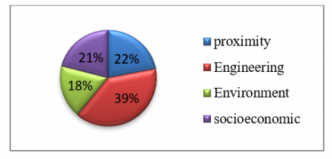
Weight can be defined as the value assigned to an evaluation criterion which indicates the importance of each criterion in relation to the others. There are different techniques by which weights are determined: classification, pairwise comparison and analysis method. In this research, the weights of the sub-criteria were deduced through a group of previous literature shown in Table 3, while the values of the main criteria were obtained using the AHP method, which is one of the most effective techniques presented by Saati (1977) pairwise comparison method, for calculating criteria Weighting using comparison matrix The comparison matrix indicates the importance of the criterion in the columns compared to the criterion in the rows in order to determine which of the two criteria is more important and to allocate a pairwise comparison was carried out using expert opinions by assigning a score of 9 points from 1 to 9 Table 2. The scores are from experts and then imported into the AHP Online System platform, and the final weight for each criterion is obtained. The results of the weights are shown in the Table 3, Figure 5.
Table 2. Saaty and Vargas preference scales
|
Intensity of importance |
Description |
|
1 |
Equal importance |
|
2 |
Equal to average importance |
|
3 |
Average importance |
|
4 |
Average to strong importance |
|
5 |
Strong importance |
|
6 |
Strong to very strong importance |
|
7 |
Very strong importance |
|
8 |
Very strong or super strong importance |
|
9 |
Super strong importance |
Figure 5. A graph showing the percentages of the weights of the main criteria obtained by the AHP method
Table 3. Criteria weights by using pairwise comparison method (AHP)
|
Main criteria |
Sub criteria |
Normalized weights for sub criteria from previous studies such as [5, 8, 24, 25] |
Normalized weights for main criteria from AHP method 100% |
|
Proximity |
Villages Wells Rivers Hospitals Schools Oil pipelines Airports Parks |
0.1 0.14 0.20 0.14 0.1 0.1 0.12 0.1 |
22 |
|
Engineering |
Soil Roads Slope Railways Valleys |
0.25 0.25 0.07 0.15 0.28 |
39 |
|
Environment |
Groundwater LULC |
0.3 0.7 |
18 |
|
Socio Economic |
Public acceptance Cost |
0.4 0.6 |
21 |
*Consistency rate: 0.023
The third step is the process of combining the various layers of sub-criteria obtained by GIS to form a unified map for each major criteria. This process is done through the tool Raster Calculator (Map Algebra) by giving each layer its weight through the following equation.
$\mathrm{S}=\sum \mathrm{Wi}^* \mathrm{Xi}$ (1)
where, Xi is standardized raster layers, Wi is layer’s weight, and S shows the final map.
The final step is to produce a suitable map for the landfills by overlaying the standardized maps of the main criteria by means of the same equation that was mentioned above. All the standardized maps were Combined according to the formula in ArcGIS10.8 and an appropriate map of final waste dumps has been created.
Which areas are better or less suitable for landfill site selection after a series of operations followed by the interaction of GIS software with AHP software can simply be demonstrated by giving each decision criterion specific importance and matching the results to produce the final map. First step, the suitability of the sites for sanitary landfill was calculated using the sub-criteria parameters based on the previous studies in Table 3 using the ArcGIS 10.8 packages. based on Eq. (1), All layers of sub-criteria were added to the raster calculator to obtain the final map of the WLC parameter method for the four main criteria. Due to the differences between the maximum and minimum value of the WLC parameters, the result maps for the WLC parameters are included WLC has five comparable units, i.e., very high suitable, high suitable, moderate suitable, low suitable and not suitable, which have been used as markers for potential landfill sites because of their suitability.
In the proximity criterion map shown in the Figure 6 it was found that a very high fit represents the area 10%, a high fit represents 18%, a moderate fit represents 25%, a low fit represents 30%, while an inappropriate fit represents 17% of the entire study area. The map of the results for the proximity criterion shows that the appropriate areas, suitable high and very high, are the areas that are located far from residential settlements, rivers, wells, hospitals, airports, schools, oil pipelines, and parks, while the unsuitable areas, and low appropriateness are the areas that are located near these factors. The results of the teachers support the previous studies conducted by [29, 33, 36]. From the map of spatial suitability for the proximity criterion, we find that the proposed sites (A2, A3, A4, A5) are located within the low suitability region, while the site (A1) is located within the unsuitable region due to its proximity to residential settlement factors.
Figure 6. Suitability index map for proximity criterion
Figure 7. Suitability index map for engineering criterion
Figure 8. Suitability index map for environment criterion
The second criterion is the engineering criterion shown in Figure 7, in which we find a map of the results for the WLC parameters that a very high fit represents 5%, a high fit represents 20%, a moderate fit represents 30%, a low fit represents 36%, while an unsuitable 9% of the area. The soil texture of the high and very high suitable areas was clayey soil while the low and unsuitable areas were sandy soils. The main highly suitable areas suitable for landfilling had slopes between 0-4% while the low and unsuitable areas were located at slopes between 8-63 %. We find that the high and very high suitable areas are located at a medium distance from highways and railways, while the low and unsuitable areas are located near or far from the roads. The suitable areas are located outside the valleys, while the low and unsuitable areas were close to the valleys. The results of WLC parameters support the previous studies conducted by [38, 41]. These studies showed that areas with fine to medium slopes integrated with clay soil and medium distances from main roads and away from the valleys area were suitable for sanitary landfill sites. The proposed landfill sites (A2, A3) are located within the high suitable region, (A1, A5) are located within the low suitable region, while A4 is located in the unsuitable region.
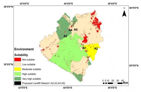
The third criterion is the environmental criterion resulting from the superposition of the two criteria, the depths of groundwater, and the land uses shown in Figure 8, in which we find a map of the results for the WLC parameters that a very high fit represents 12%, a high fit represents 28%, a moderate fit represents 6%, a low fit represents 49%, while an unsuitable 5% of the area. The groundwater depths in the areas with high suitability ranged between 50-150m, the low suitability ranged between 30-50m, while the unsuitable ones were less than 20m. High suitability areas are cropland land use areas, temperate areas are vegetation cover areas, while less favorable and unsuitable areas are residential areas and water bodies. The results of WLC parameters support previous studies conducted by [47, 49]. These studies showed that areas with remote groundwater depths, cropland uses and vegetation cover are suitable for sanitary landfill sites. The proposed landfill sites (A1, A2) fall within the moderate suitability zones, (A5) are located within the low suitable region, while the sites (A3, A4) fall within the very high suitability zone.
The last criterion is the social and economic criterion resulting from the superposition of the two criteria, cost and public acceptance shown in the Figure 9. in which we find a map of the results for the WLC parameters that a very high fit represents 18%, a high fit represents 22%, a moderate fit represents 14%, a low fit represents 39%, while an unsuitable 8% of the area. The cost of the appropriate area was low and this is a result of its proximity to the source of waste generation. High cost as a result of its remoteness from the source of waste generation, thus increasing waste disposal expenses. The general acceptance of the appropriate area was somewhat good, while the unsuitable areas were unacceptable and had negative effects on society in general. The proposed landfill sites (A1, A2, A4) are all within the very high suitability zone, (A3) are located within the moderate suitable region, while the site (A5) within the high suitability zone.
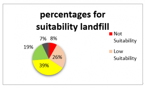
The final step is to produce a spatial adequacy map of the landfill sites, where the spatial adequacy is calculated using the main criteria parameters based on the AHP analytical hierarchy based on the pairwise comparison matrix based on the opinions of the experts in Table 3 using ArcGIS 10.8 packages. based on Eq. (1), All major criteria layers were added to the raster calculator and multiplied by the overlay methods to create the final map for the raster file as in Figure 10. This map included five comparable units, very high fit, high fit, moderate fit, low fit, and inappropriate fit Which were used as markers for potential landfill sites because of their suitability. The results indicated that 7% represent very high suitability, 19% are high suitability areas, 39% represent moderate suitability areas, 26% represent low suitability, and 8% are unsuitable areas. the entire study area as shown in Figure 11.
Figure 9. Suitability index map for social economic criterion
Figure 10. Final landfill suitability
Figure 11. Graph shown percentages for suitability landfill
The process of selecting landfills in most Iraqi cities is carried out using traditional methods that are not specific and random in most cases. High accuracy in the selection process. This study reveals many of the negatives that exist in the process of integrated waste management by comparing the current site in the city with the final suitability map in this study, and thus it becomes clear whether the current management in the city is sound or not. In this study, four main sets of criteria, namely proximity, engineering, environmental, social, and economic, were taken in order to determine the most suitable landfill site. There are five proposed sanitary landfill sites in this study, where these sites are compared with the final fit map obtained. We find that the two sites (A3, A2) are among the most suitable sites because they are located within a region of high affinity, while the sites (A1, A4, A5) is in a region of low affinity and is preferred to be excluded from the proposed options. Based on the expert opinions gathered through a questionnaire, proximity criteria received a weight of 22%, engineering criteria received 39%, environmental criteria received 18%, and socio-economic criteria received 21%. We find the difference in the current study from the previous studies that the sub-criteria were collected within four main groups because there is a huge number of specific criteria for the process of selecting landfill sites, and this step facilitates the decision-makers in choosing the appropriate site.
[1] Alavi, N., Goudarzi, G., Babaei, A.A., Jaafarzadeh, N., Hosseinzadeh, M. (2013). Municipal solid waste landfill site selection with geographic information systems and analytical hierarchy process: a case study in Mahshahr County, Iran. Waste Management & Research, 31(1): 98-105. https://doi.org/10.1177/0734242X1245609
[2] Olay-Romero, E., Turcott-Cervantes, D.E., del Consuelo Hernández-Berriel, M., de Cortázar, A.L.G., Cuartas-Hernández, M., de la Rosa-Gómez, I. (2020). Technical indicators to improve municipal solid waste management in developing countries: A case in Mexico. Waste Management, 107: 201-210. https://doi.org/10.1016/j.wasman.2020.03.039
[3] Eskandari, M., Homaee, M., Mahmodi, S. (2012). An integrated multi criteria approach for landfill siting in a conflicting environmental, economical and socio-cultural area. Waste Management, 32(8): 1528-1538. https://doi.org/10.1016/j.wasman.2012.03.014
[4] Tchobanoglous, G. (1993). Integrated solid waste management: engineering principles and management issues. 628 T3.
[5] Alanbari, M.A., Al-Ansari, N., Jasim, H.K. (2014). GIS and multicriteria decision analysis for landfill site selection in AL-Hashimyah Qadaa. Natural Science, 6(5): 282-304. https://doi.org/10.4236/ns.2014.65032
[6] Sameer, Y.M., Abed, A.N., Sayl, K.N. (2023). Geomatics-based approach for highway route selection. Applied Geomatics, 15(1): 161-176. https://doi.org/10.1007/s12518-023-00495-x
[7] Muneer, A.S., Sayl, K.N., Kamal, A.H. (2021). Modeling of spatially distributed infiltration in the Iraqi Western Desert. Applied Geomatics, 13: 467-479. https://doi.org/10.1007/s12518-021-00363-6
[8] Karimi, H., Amiri, S., Huang, J., Karimi, A. (2019). Integrating GIS and multi-criteria decision analysis for landfill site selection, case study: Javanrood County in Iran. International Journal of Environmental Science and Technology, 16: 7305-7318. https://doi.org/10.1007/s13762-018-2151-7
[9] Mallick, J. (2021). Municipal solid waste landfill site selection based on fuzzy-AHP and geoinformation techniques in Asir Region Saudi Arabia. Sustainability, 13(3): 1538. https://doi.org/10.3390/su13031538
[10] Osra, F.A., Kajjumba, G.W. (2020). Landfill site selection in Makkah using geographic information system and analytical hierarchy process. Waste Management & Research, 38(3): 245-253. https://doi.org/10.1177/0734242X19833153
[11] Tercan, E., Dereli, M.A., Tapkın, S. (2020). A GIS-based multi-criteria evaluation for MSW landfill site selection in Antalya, Burdur, Isparta planning zone in Turkey. Environmental Earth Sciences, 79(10): 246. https://doi.org/10.1007/s12665-020-08974-9
[12] Sameer, Y.M., Abed, A.N., Sayl, K.N. (2021). Highway route selection using GIS and analytical hierarchy process case study Ramadi Heet rural highway. In Journal of Physics: Conference Series, IOP Publishing, 1973(1): 012060. https://doi.org/10.1088/1742-6596/1973/1/012060
[13] Khudhair, M.A., Sayl, K.N., Darama, Y. (2020). Locating site selection for rainwater harvesting structure using remote sensing and GIS. In IOP Conference Series: Materials Science and Engineering, IOP Publishing, 881(1): 012170. https://doi.org/10.1088/1757-899X/881/1/012170
[14] Majid, M., Mir, B.A. (2021). Landfill site selection using GIS based multi criteria evaluation technique. A case study of Srinagar city, India. Environmental Challenges, 3: 100031. https://doi.org/10.1016/j.envc.2021.100031
[15] Şener, Ş., Sener, E., Karagüzel, R. (2011). Solid waste disposal site selection with GIS and AHP methodology: A case study in Senirkent-Uluborlu (Isparta) Basin, Turkey. Environmental Monitoring and Assessment, 173(1): 533-554. https://doi.org/10.1007/s10661-010-1403-x
[16] Aydi, A., Zairi, M., Dhia, H.B. (2013). Minimization of environmental risk of landfill site using fuzzy logic, analytical hierarchy process, and weighted linear combination methodology in a geographic information system environment. Environmental Earth Sciences, 68: 1375-1389. https://doi.org/10.1007/s12665-012-1836-3
[17] Kumar, S., Hassan, M.I. (2013). Selection of a landfill site for solid waste management: an application of AHP and spatial analyst tool. Journal of the Indian Society of Remote Sensing, 41: 45-56. https://doi.org/10.1007/s12524-011-0161-8
[18] Beskese, A., Demir, H.H., Ozcan, H.K., Okten, H.E. (2015). Landfill site selection using fuzzy AHP and fuzzy TOPSIS: A case study for Istanbul. Environmental Earth Sciences, 73: 3513-3521. https://doi.org/10.1007/s12665-014-3635-5
[19] Bahrani, S., Ebadi, T., Ehsani, H., Yousefi, H., Maknoon, R. (2016). Modeling landfill site selection by multi-criteria decision making and fuzzy functions in GIS, case study: Shabestar, Iran. Environmental Earth Sciences, 75: 1-14. https://doi.org/10.1007/s12665-015-5146-4
[20] Rahmat, Z.G., Niri, M.V., Alavi, N., Goudarzi, G., Babaei, A.A., Baboli, Z., Hosseinzadeh, M. (2017). Landfill site selection using GIS and AHP: A case study: Behbahan, Iran. KSCE Journal of Civil Engineering, 21: 111-118. https://doi.org/10.1007/s12205-016-0296-9
[21] Torabi-Kaveh, M., Babazadeh, R., Mohammadi, S.D., Zaresefat, M. (2016). Landfill site selection using combination of GIS and fuzzy AHP, a case study: Iranshahr, Iran. Waste Management & Research, 34(5): 438-448. https://doi.org/10.1177/0734242X16633777
[22] Hashim, H.Q., Sayl, K.N. (2021). Detection of suitable sites for rainwater harvesting planning in an arid region using geographic information system. Applied Geomatics, 13: 235-248. https://doi.org/10.1007/s12518-020-00342-3
[23] Assaf, A.T., Sayl, K.N., Adham, A. (2021). Surface water detection method for water resources management. In Journal of Physics: Conference Series, IOP Publishing, 1973(1): 012149. https://doi.org/10.1088/1742-6596/1973/1/012149
[24] Adewumi, J.R., Ejeh, O.J., Lasisi, K.H., Ajibade, F.O. (2019). A GIS-AHP-based approach in siting MSW landfills in Lokoja, Nigeria. SN Applied Sciences, 1: 1-18. https://doi.org/10.1007/s42452-019-1500-6
[25] Ajibade, F.O., Olajire, O.O., Ajibade, T.F., Nwogwu, N.A., Lasisi, K.H., Alo, A.B., Owolabi, T.A., Adewumi, J.R. (2019). Combining multicriteria decision analysis with GIS for suitably siting landfills in a Nigerian state. Environmental and Sustainability Indicators, 3-4: 100010. https://doi.org/10.1016/j.indic.2019.100010
[26] Chabuk, A., Al-Ansari, N., Hussain, H.M., Knutsson, S., Pusch, R. (2016). Landfill site selection using geographic information system and analytical hierarchy process: A case study Al-Hillah Qadhaa, Babylon, Iraq. Waste Management & Research, 34(5): 427-437. https://doi.org/10.1177/0734242X16633778
[27] Rushton, L. (2003). Health hazards and waste management. British Medical Bulletin, 68(1): 183-197. https://doi.org/10.1093/bmb/ldg034
[28] Minichilli, F., Bartolacci, S., Buiatti, E., Pallante, V., Scala, D., Bianchi, F. (2005). A study on mortality around six municipal solid waste landfills in Tuscany Region. Epidemiologia e Prevenzione, 29(5-6 Suppl): 53-56.
[29] Allen, A., Brito, G., Caetano, P., Costa, C., Cummins, V., Donelly, J., Fernades, C., Koukoulas, S., O’Donnell, V., Robalo, C., Vendas, D. (2002). Procedure for the location of landfill sites using a GIS model. In 9th Congress of the International Association of Engineering Geology and the Environment, Durban, 16-20.
[30] Allen, A.R. (2002). Attenuation: A cost effective landfill strategy for developing countries. In Proceedings of 9th Congress of the International Association for Engineering Geology and the Environment, 136-147.
[31] Uyan, M. (2014). MSW landfill site selection by combining AHP with GIS for Konya, Turkey. Environmental Earth Sciences, 71: 1629-1639. https://doi.org/10.1007/s12665-013-2567-9
[32] Chalkias, C.N., Stournaras, G. (1997). GIS application for the selection of sanitary waste disposal landfills and quarries sites in major Sparti area, Greece. In Engineering Geology and the Environment, 1675-1680.
[33] Dörhöfer, G., Siebert, H. (1998). The search for landfill sites-requirements and implementation in Lower Saxony, Germany. Environmental Geology, 35: 55-65. https://doi.org/10.1007/s002540050292
[34] Demesouka, O.E., Vavatsikos, A.P., Anagnostopoulos, K.P. (2013). Suitability analysis for siting MSW landfills and its multicriteria spatial decision support system: Method, implementation and case study. Waste Management, 33(5): 1190-1206. https://doi.org/10.1016/j.wasman.2013.01.030
[35] Shaikh, M.A. (2006). Using GIS in solid waste management planning: A case study for Aurangabad, India. Institutionen för datavetenskap.
[36] Milevski, I., Dimitrovska, O., Markoski, B., Gorin, S. (2012). Optimal landfill site selection as prevention of diseases. In Medical Geography, Symposium with International Participation “Traditions and Modernity in Medical Geography and Disaster Medicine”, Sofia, 63-71.
[37] Alanbari, M., Al-Ansari, N., Jasim, H., Knutsson, S. (2014). Al-Mseiab Qadaa landfill site selection using GIS and multicriteria decision analysis. Engineering, 6(9): 526-549.
[38] Khan, D., Samadder, S.R. (2015). A simplified multi-criteria evaluation model for landfill site ranking and selection based on AHP and GIS. Journal of Environmental Engineering and Landscape Management, 23(4): 267-278. https://doi.org/10.3846/16486897.2015.1056741
[39] Baban, S.M.J., Flannagan, J. (1998). Developing and implementing GIS-assisted constraints criteria for planning landfill sites in the UK. Planning Practice & Research, 13(2): 139-151. https://doi.org/10.1080/02697459816157
[40] Cointreau, S. (2004). Sanitary landfill design and siting criteria. Washington, DC: World Bank, 1-6.
[41] Rapti-Caputo, D., Sdao, F., Masi, S. (2006). Pollution risk assessment based on hydrogeological data and management of solid waste landfills. Engineering Geology, 85(1-2): 122-131. https://doi.org/10.1016/j.enggeo.2005.09.033
[42] Sayl, K.N., Sulaiman, S.O., Kamel, A.H., Muhammad, N.S., Abdullah, J., Al-Ansari, N. (2021). Minimizing the impacts of desertification in an arid region: A case study of the west desert of Iraq. Advances in Civil Engineering, 2021: 1-12. https://doi.org/10.1155/2021/5580286
[43] Vatalis, K., Manoliadis, O. (2002). A two-level multicriteria DSS for landfill site selection using GIS: case study in Western Macedonia, Greece. Journal of Geographic Information and Decision Analysis, 6(1): 49-56.
[44] Khamehchiyan, M., Nikoudel, M.R., Boroumandi, M. (2011). Identification of hazardous waste landfill site: A case study from Zanjan province, Iran. Environmental Earth Sciences, 64: 1763-1776. https://doi.org/10.1007/s12665-011-1023-y
[45] Hussin, W.M.A.W., Kabir, S., Din, M.M., Jaafar, W.W. (2010). Modelling landfill suitability based on multi-criteria decision making method. Interdisciplinary Themes Jour, 2(1): 20-30.
[46] Adewumi, J.R., Akomolafe, J.K., Ajibade, F.O., Fabeku, B.B. (2016). Application of GIS and remote sensing technique to change detection in land use/land cover mapping of Igbokoda, Ondo State, Nigeria. Journal of Applied Science & Process Engineering, 3(1): 34-54. https://doi.org/10.33736/jaspe.173.2016
[47] Olatona, O.O., Nduka, O.V. (2017). Integration of geographical information system and multicriteria decision analysis for landfill site selection in Akure, Nigeria. AASCIT Journal of Environment, 2(2): 23-33.
[48] Mohammed, O.A., Sayl, K.N. (2021). A GIS-based multicriteria decision for groundwater potential zone in the west desert of Iraq. In IOP Conference Series: Earth and Environmental Science, IOP Publishing, 856(1): 012049. https://doi.org/10.1088/1755-1315/856/1/012049
[49] Zelenović Vasiljević, T., Srdjević, Z., Bajčetić, R., Vojinović Miloradov, M. (2012). GIS and the analytic hierarchy process for regional landfill site selection in transitional countries: A case study from Serbia. Environmental Management, 49: 445-458. https://doi.org/10.1007/s00267-011-9792-3
[50] Mohammed, O.A., Sayl, K.N. (2020). Determination of groundwater potential zone in arid and semi-arid regions: A review. In 2020 13th International Conference on Developments in eSystems Engineering (DeSE), IEEE, 76-81. https://doi.org/10.1109/DeSE51703.2020.9450782