Nina Yulianti*![]() | Fengky Florante Adji
| Fengky Florante Adji![]() | Kurniawan Eko Susetyo
| Kurniawan Eko Susetyo![]() | Kitso Kusin
| Kitso Kusin![]() | Daisuke Naito
| Daisuke Naito![]()
© 2023 IIETA. This article is published by IIETA and is licensed under the CC BY 4.0 license (http://creativecommons.org/licenses/by/4.0/).
OPEN ACCESS
18 kilometers from Palangka Raya City, the capital of Central Kalimantan, Borneo’s part of Indonesia, Kalampangan is populated by farming communities who primarily produce important tropical crops. This former transmigrant village was occupied in the early 1980s, is located on peatland with a depth of approximately 4 meters. Peat is a vulnerable, spongy and acid soils. Recently, pressure from regulation and market demands for low carbon products has forced some local farmers to stop burnt and over-drainage and adapt their agricultural practices to more sustainable practices. The adoption rate, however, is still low. This study identifies the challenges and efforts towards sustainable management in Kalampangan’s agricultural communities, based on the information collected during a field visit, soil sampling and the discussion sessions, held with the selective farming and its community. The roles of the stake-holder through transformative leadership were shown to be very important for the shift from conventional to environmentally-friendly practices.
farming, Indonesia, Kalimantan, Borneo, peatland, sustainable management
Borneo is the top third of the largest island in the world with reaching 740,000km2. It is divided into four political regions, namely five provinces of Kalimantan belong to Indonesia (~73% of the island), Sabah and Sarawak are part of Malaysia (~26% of the island), and a small remaining region comprises the sultanate of Brunei (~1% of the island). To the north and northwest, the South China Sea, to the northeast, the Sulu Sea, to the east, the Celebes Sea and the Makassar Strait, and to the south, the Java Sea and the Karimata Strait, encircle the island as it stands today. Sumatra and the Malay Peninsula are to the west of Borneo. Java and Sulawesi, two Indonesian islands, are to the south and east, respectively. The Philippine Islands are located in the northeast. Borneo is located on the Equator. It is 1,336 km long from northeast to southwest and 960 km wide at its widest point. Although the island is mostly mountainous, there are extensive lowlands, particularly in Central Kalimantan and Sarawak, that are frequently swampy along the coasts. A long series of mountain ranges extend southwest across the island from Mount Kinabalu in the far northeast, which is the highest point on the island and the tallest peak in Malaysia at 4,101 metres. Equatorial, hot, and humid, Borneo's climate can be roughly divided into two seasons: a relatively dry summer for the rest of the year and a wet monsoonal period between October and March [1, 2].
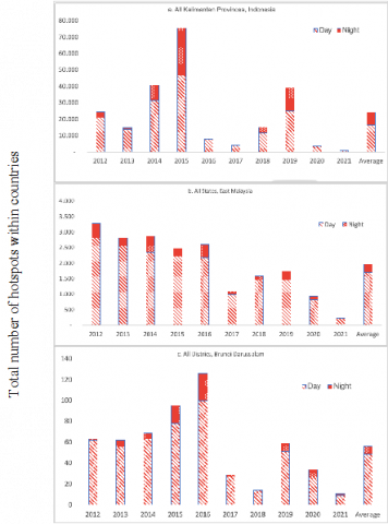
This region is covered by rich tropical rainforest and one of the noteworthy ecosystems is the peat swamp forest (PSF) and the converted peatlands. Indonesia has ~140,000 km2 of peatlands [3], Malaysia has ~18.000 km2 of peatlands [4] and Brunei has ~900 km2 of an extensive peat swamp forest [5, 6]. The PSF had experience several greatest disturbances such annual fire over the last decade as shown in Figure 1. Extreme weather conditions caused by El Niño, which increases ocean temperatures in the Southern Ocean and this region typically experiences lower rainfall amount (negative anomaly). Then, the fires became noticeable in very strong El Nino in 1997/1998 [7] and recurrence in very strong El Nino in 2015/2016 [8]. Southeast Asia has seen an increase in fire frequency in recent years, particularly on the islands of Borneo and where agriculture and wood harvesting have increased. High carbon and particulate emissions are being produced by these peatland fires, along with structural, biomass, and long-term changes to the forest [9]. The smoke from the fires creates massive air pollution, which is commonly referred to as “transboundary haze”-across Indonesia, Malaysia, Singapore and other Southeast Asia countries It is considered to be one of the causes of global warming and climate change across ASEAN countries [10].
Figure 1. The Annual MODIS Hotspots (Fires) in Borneo, from 2012 to 2021 (Note: the data is till 25 June 2021)
Prior to the Sustainable Development Goals agenda on 2015, ASEAN members started to approve the ASEAN Agreement on Transboundary Haze Pollution (AATHP) in 2002. This was a response to the severe land and forest fires of 1997/1998, which were strongly associated with El Nino and miss-management of peatland swamp forest [11-13]. For months during the dry season, severe haze and thousand fires were cover Malaysia Peninsular and Indonesia main island, especially Sumatra and Kalimantan. Four other ASEAN countries were spread by the transboundary haze, namely Malaysia, Singapore, Brunei, Thailand, and Philippines [14, 15]. Fires and haze occur almost every year for the last two decades. As has been proven by previous research, this condition causes not only short-term and sporadic but also long-term and global impacts such carbon emission, long-term health problem and the extinction of biodiversity [16-20]. Global warming and climate change are allegedly driven by the frequent forest and land fires, where mostly be detected from tropical peatland of ASEAN. Then, more efforts to reduce the threat and effect of annual fire and hazed are required, and the countries still could go further in preventing the future fires.
Fire in Indonesian Borneo and Sumatra is contributing 35 to 50 % of Southeast Asia [21] One area of concerns is Central Kalimantan Province. This province has higher fire occurrence than the other four provinces; even compared to two states in Malaysia and all districts of Brunei [22]. This province is not only an affected area but also exposed to smoke haze during the months of fires. There is a very vurnerable are so called ex Mega Rice Project. The aim of the project was to provide new agricultural land by converting one million hectares of peat and swamp land for rice cultivation. The project is carried out by constructing canals with the aim of splitting the peat dome and drain acid water. There, the main canal (SPI) was built for 222 kilometers, the main primary canal is 620 kilometers, the embankment area is 82 hectares, the business area is 61,000 hectares, the rice fields area is 144,440 hectares, and the yard area is 14,375 hectares. The project was ended in complete failure in the late 1990s. The cause of this failure is the peatlands are less suitable for dryland-based crops. Therefore, remaining transmigrant community in an area of Kalampangan (18 kilometers from Palangka Raya City, the capital of Central Kalimantan) was rely on slash and burn practice, where fires set intentionally in preparation for farming. This unsustainable way causes more fire and smoke haze pollution to the surrounding areas.
ASEAN Peatland Management Strategy (APMS) 2006-2020 was endorsed by the 12th ASEAN Ministerial Meeting on Environment (AMME), just a few months after the severe fire and haze in 2006. The main goal of the strategy is to promote sustainable management of peatlands among ASEAN members through collective actions and enhanced cooperation to support and sustain local livelihoods, reduce risk of fire and associated haze and contribute to global environmental management [23]. There are two project to support the implementation of sustainable peatland management namely ASEAN Peatland Forests Project had completed in 2014 and SEApeat Project had completed in 2016. The countries that involved in both projects include Malaysia, Indonesia, Philipines and Vietnam. Post severe fire and haze in 2015, Indonesia Government was established the Peatland Restoration Agency (BRG) through Indonesia Presidential Regulation No.1 of 2016. The main task is to accelerate the recovery and restoration of the hydrological function of peat damaged by fire and drainage of around two million hectares by 2020. The task of this agency is succeeded by the Peat and Mangrove Restoration Agency with the broader aim of facilitating the acceleration of peat restoration implementation and accelerating mangrove rehabilitation in Indonesia. According to Indonesia Presidential Regulation No.120 of 2020, three provinces in Kalimantan (or Borneo Indonesia) became the priority areas for peatland and three provinces became the priority areas for mangrove rehabilitation [22].
This study was carried out in the renowned Ex-Mega Rice Project (EMRP) areas in 1996/1997 (one million hectares), some of which will be included in the national government's New Food Estate (FE) Nation Program in 2020/2021 (more than one hundred hectares) referred to [24]. Fertile land, skilled labor, and expertise or good management are required for peatland areas to produce high yields and high-quality agriculture. Particularly in the last two decades, Indonesia has come under increasing fire for its commercial unsustainable management of peatland. Adaptive lowland agriculture development is required to achieve a balance between productivity, environmental preservation, and social-cultural ecosystem services [25]. Several methods have been used in Central Kalimantan, ranging from shallow to deep peatland, and from traditional to modern agriculture only in certain areas. Then, more research and lessons learned seem to be necessary to fill in the gaps for large-scale sustainable farming application.
Utilizing farming methods that take into account ecological cycles is known as sustainable farming or, in a broader sense, sustainable agriculture [26]. It is also sensitive to the interactions between human and the environment as a whole. Simply put, sustainable farming is ecological farming by supporting strategies and tactics that are financially feasible, environmentally responsible, and safeguard public health. This study would like to see the possibility of replicating the model from one village to neighboring villages with similar profiles. As a result, we aim (i) to study the current farming practices in Kalampangan, where is one of remaining agriculture areas in ex Mega Rice Project, (ii) to identify challenges in promoting sustainable peatland management through the introduction of environmentally-friendly farming in deep peatland, and (iii) to understand how leadership transformation and sustainability concepts can contribute towards sustainability and promote well-being of the farmers in the village level.
2.1 Case study site
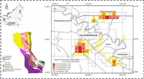
The area interest of this study is Kalampangan, where covering north of Ex Mega Rice Project and located in Sebangau District, 18 kilometers from Palangka Raya City, Central Kalimantan (Figure 2). Kalampangan is lied from S 2o16’48” to 2o20’24” and from E 114o00’18” to 114o02’42”. This area serves as a farming hub for Palangka Raya City and the surrounding area. Since the 1980s, most farmers in Kalampangan have converted over 3 meters of peatland deep to agricultural land. Sweet corn, kale, spinach, mustard greens, chilies, long beans, eggplant, and cucumber are some of their most common products. This area and its surroundings are also becoming a natural laboratory for tropical peatland farming [27] and peatland restoration [28].
Previous studies on improving soil fertility, growth, yields, and reducing slash and burn in the study area were conducted to test the effectiveness of organic source ameliorants and fertilizers such as manure, biochar, compost, and ash [29-32]. Another study focused on implementing agriculture based on natural conditions, specifically farming in wetlands, such as selecting water tolerant plants [33, 34], water management [35, 36], and agroforestry farming or non-monoculture crops [37, 38].
Figure 2. Map of Kalampangan and fire prone area in southeast Palangka Raya City
However, as shown in Figure 2, fires frequently occurred in the southeast of Palangka Raya City, including the Kalampangan area. In Kalampangan Canal, there were 290 distinct fires in 2002 and 218 fires in 2009. Their respective contributions were approximately 57% and 40% of the total fire in the north area [39]. A more severe fire occurred before the COVID-19 phenomenon was in the El Nino year of 2019. Some peat layer loss ranges from 20 to 50 cm as a result of frequent fires [40, 41]. Carbon emissions from peat fires are a major problem in the areas. The study area should then be researched in terms of sustainable peatland farming and climate change mitigation.
2.2 Methods
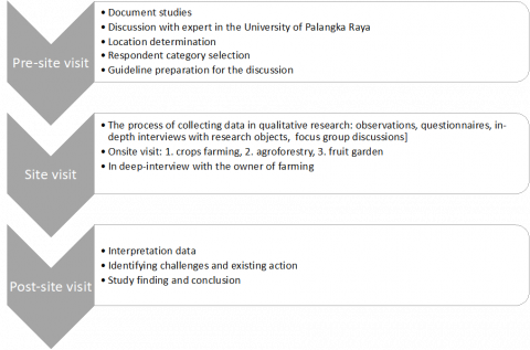
Documentary research was used in combination with a qualitative approach for data collection. The documentary research included a review of the literature on existing development practices such as the sustainable livelihoods framework and participatory impact assessment approaches. It also examined sources that evaluate the limitations of past and current impact assessment approaches to sustainable peatland initiatives, implemented by various institutions such as university, government and farmer group. The purposive sampling method was used for the selection of participants of both the Focus Group Discussions (FGDs), in-deep interview and online questioner, in order to include with a quantitative choice experiment (CE) in Kalampangan that focused according previous similar study [42].
Figure 3. Flowchart of Methodology
A FGD with fifteen farmers in village and deep interview with communal leader were conducted on March 28, 2019. Further, a google form questioner for the local community in Kalampangan was conducted from 25 May to 25 June 2021. The online instrument was chosen with the consideration that the timing of the questionnaire coincided with the Community Activities Restrictions Enforcement (semi-lockdown of COVID-19 pandemic) in Indonesia, which was not possible to have face-to-face meetings with respondents. The survey contains 100 questions, is entirely anonymous and implemented based on the flowchart for the respondent to follows. In Figure 3, the main instrument for both the discussion and questioner is a “guide” (all open-ended questions, which are semi- structured to ensure the session does not go astray to other topics). This study applied a method similar to the study in Bundu Tuhan, Sabah, Malaysia as mentioned in the study of Yulianti et al. [43].
3.1 Current farming practices
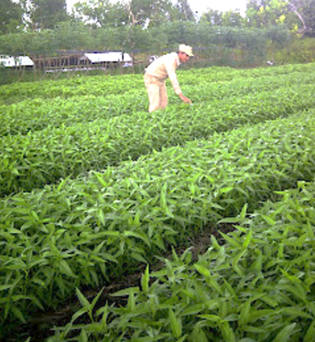
The beginning of the Kalampangan Village came from the transmigration area in 1980 in Bereng Bengkel Village, Pahandut District, Palangka Raya Municipality. Since the end of 1990s, the most of transmigrant farmer in Kalampangan, the southern part of Palangka Raya City growth with various crops instead of paddy. Observation in the first farm carried out on August 2015. One of the most popular and easy-to-cultivate crops in the area is Kangkung (Ipomoea spp.) as in Figure 4. This plant has other names, namely water spinach, swamp cabbage, sater convovulus, and kale. There is name in local Indonesian tribes such as kangkong (Dayak), naniri, lare (Sulawesi), debtko, behob, tatako, kangko (Maluku), pangpung (Bali) and lara (Bima Nusa Tenggara).
This vegetable can grow well in the yard and former paddy fields. Kangkung can live anywhere, both in the lowlands and highlands, so that water spinach is easily found in almost all parts of Indonesia. Soils with a high organic matter content such peat soils are preferred. Kangkung can provide optimum results in tropical lowland conditions with high temperatures and short irradiation. The ideal temperature ranges from 25-30oC, while below 10oC the plant will be damaged. There are two types of water spinach, namely land spinach (Ipomoea reptans), which has narrow leaves and adapts to moist soil, and is harvested only once; and water spinach (Ipomoea aquatica) which has wider leaves and is arrow-shaped. This species adapts to waterlogged conditions and is harvested several times.
Figure 4. Water spinach (Ipomoea spp.) in yard of farmer
Mr. Haryono, one of the organic farmers in the Kalampangan Village area, is currently developing an organic farming method. The main crops planted are sweet corn while other vegetable crops such as water spinach, soup leaves, basil, mustard greens and lettuce are planted while waiting for the corn harvest to arrive. The initial process from planting to harvesting in the fields does not use chemical fertilizers or pesticides like other farmers in the area. The perception of vegetable farmers in Kalampangan Village, Palangka Raya City in the use of organic fertilizers is still quite good. Innovation in the use of organic fertilizers with the characteristics of relative advantage, suitability, complexity, possibility to apply in their farm. The decision of farmers to adopt the technology of using organic fertilizers is very dependent on how farmers interpret or perceive what are the characteristics of the organic fertilizers themselves [44]. Further, Rario et al. [45] found that socioeconomic level was significantly related and had little effect on knowledge, perception and handling of pesticides.
We visited the second farm on March 2019, which the owner has adopted agroforestry system. This 1.75 Ha peat land in the Kalampangan area, Palangka Raya is managed by Ahmad Tamanuruddin (62) or better known as Pak Taman Recently, a quite popular plant as an agroforestry core in peat and swamp land is Jelutung (Dyera polyphylla). This plant is native to tropical forests that can grow in riverbanks, swamps and peat swamps. This plant is able to grow in the ground water level of less than 40 cm, this is because jelutung has breath roots that can help this plant deal with standing water for a long time [46]. Cultivation of marsh jelutung on peatlands is usually carried out without the use of canals (drainage) to regulate water [47]. The cultivation methods of jelutung are generally divided into two, namely monoculture and agroforestry or mixed (intercropping with other plants). Jelutung plants can be used either for wood products or non-timber products in the form of sap. According to Budiningsih and Effendi [48]. Indonesia is one of the largest suppliers of jelutung sap to the importing countries. The largest importing country of jelutung is Japan. The sap is tapped as a mixture of chewing gum and used in the manufacture of paints and paper [49].
Figure 5. Jelutung (Dyera polyphylla) Agroforestry
About 1.75 Ha peat land in the Kalampangan area, Palangka Raya is managed by Ahmad Tamanuruddin (62) or better known as Pak Taman. He explained that his land which is planted with chili, spinach, corn as well as some perennials such as Jelutung (Dyera polyphylla) and fruits such as bananas, rambutan and oranges thrives on peatlands (Figure 5). He promotes PLTB or tillage non burning with three understandings, first is Land Clearing without Burning which means the initial process of building or clearing land for farmers. The second is Land Preparation without Burning, which is a habit of farmers at the time of the planting season by not burning the land [50]. The third is Land Management Without Burning, namely controlling and processing land in a wise and controlled way. All stages should be done without having to burn the land in the process.
The Horticultural Agrotourism Place visited in Palangka Raya is the Kameloh Misik Fruit Picking Tourism Garden. This orchard is better known as the Kalampangan Fruit Garden which is an Agrotourism Garden located in the Kalampangan Village, Sabangau District. The location is 18 km north of Palangka Raya City, Central Kalimantan. This fruit garden has an area of about 5,000 hectares with the dominance of dragon fruit cultivation and others which are managed by the local community of Kalampangan Village. This garden sart after fire in 2015 and growths on peat soil with a depth of approximately 4 meters. In this location there is less dragon fruit development and is a rural area that is considered successful. Sumardi, a member of the Berkah Tani Farmers Group, Kalampangan Village, Jekan Raya District, Palangka Raya City, develops dragon fruit (Hylocereus undatus) as shown in Figure 6. His dragon fruit plant is 3 years old and covers an area of 7 hectares. This plant has produced dragon fruit as much as 30-40 tons at a price of Rp 15 - 20 thousand per kg. Most of the fruit produced is sold for consumption by urban residents in Palangka Raya.
Figure 6. Dragon Fruit (Hylocereus undatus) Agro-tourism
3.2 Annual forest and land fire occurrences: A challenge on sustainable peatland
3.2.1 When fires occur?
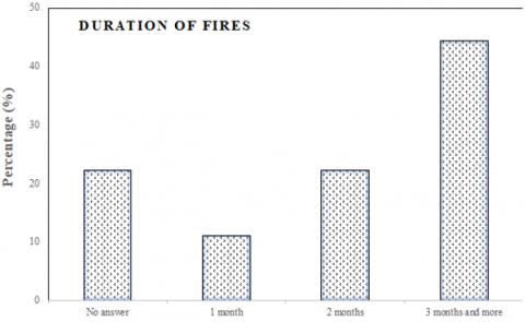
Figure 7. Severe fire occurrences and duration of fires based on the respondent’s answer in Kalampangan Village
The question about the when the most fire activities was a multiple tick question and this explains why the sum of the percentage was higher than 100 %. Figure 7 (above) show the most fire not only in 2015 and 2019 but also the other years (~40% of respondents), followed by only 2015 (~30% of respondents) and only 2019 (~20% of respondents). Our previous study in scale of Central Kalimantan Province mentioned that the above average fires occur in 2006, 2009, 2014, 2015 and 2019 (Figure 7). A severe drought coupled with the land degradation has sparked annual fire season in study site and the duration of can reaches three months and more (~40% of respondents). However, the other was not answer (~20% of respondents) the exactly how long the fire season in Kalampangan Village. The annual cycle with a rainfall minimum in MJJ/ASO is dominant in the most of southern part of Indonesia [51]. Further, Putra and Hiroshi [13] found there is a strong relationship among the precipitation pattern and fire occurrences in Central Kalimantan Province.
3.2.2 What the causes of fires?
Respondents perceived the general causes of fires as being different in terms of severity of fires Respondents perceived that the general causes of fires differed in terms of the severity of fires caused by humans and the environment. Figure 8 (a) shows that dry peat layer is the most common fire cause, chosen by 30% of respondents. Other causes include land clearing and waste burning (30% of respondents). The remaining factors were not specified by the respondent. According to the previous study, the most common cause of fire in Central Kalimantan is environmental conditions, followed by irresponsible human behavior.
Figure 8. Main causes of severe fire (a) and environmental causing fire (b) based on the respondent’s answer in Kalampangan Village
Figure 8 (b) depicts a more specific fire that was caused by an environmental factor. Nearly half of respondents (40%) said they had no idea what caused the fire to start. Furthermore, hot temperatures (30%) and drought (20%) were mentioned as natural factors that contribute to fires by respondents. The experts' causal variables highlighted the terms climate condition and biophysical. Rainfall, temperature, ENSO, drought, and hotspot are all examples of climate conditions. The terms land cover, land use, ground water level, land condition, peat moisture content, and peat depth are then used too [52].
3.2.3 Is the practice of fire swiddening still practiced and is there any prohibition?
It has become a tradition for generations in almost all parts of Indonesia to use fire as part of land clearing. Table 1 consists how attitude and knowledge of respondent in three section of question. The majority of respondents, which is around 70%, still practice this way. From our previous research, it was found that the reason for the high practice of respondents who chose to clear their land by fire was because it was the fastest, most efficient, easy and practical way to clean up remaining boundaries and logs [53-55]. One of efforts to reduce or to minimize the use of fire swiddening in several area of peatland is the law enforcement of local regulation and/or customary law. Around 60 percent of the respondents were aware of the existence of a local regulation on fire prohibition but were not aware of the existence of customary law governing such prohibition in the study area. Currenty, Central Kalimantan Government was released two local regulation, namely Regional Regulation Number 1 of 2020 concerning land fire control and Governor Regulation Number 4 of 2021 concerning the clearing and management of non-peat land for indigenous peoples. Burning forest or land at this time can be categorized as an act against Dayak customary law and is contrary to the term Belom Bahadat (life with customary ethic), although the sanctions are not specifically explained in Article 96 of the Tumbang Anoi Peace Agreement [53].
Table 1. Percentage of respondent based on their practice of burning and information of regulation and law on burning prohibition in Kalampangan Village
|
Parameter: |
Percentage (%) |
|
1. Fire swiddening practice for land clearing |
|
|
-Yes |
78 |
|
-No |
22 |
|
2. Local regulations of prohibition of the practice of burning |
|
|
-There is not any |
33 |
|
-There is regulation |
67 |
|
3. Customary laws of prohibition of the practice of burning |
|
|
-There is not any |
89 |
|
-There is law |
11 |
3.2.4 How the impact on the environment?
In Table 2, we divide the impact of forest and land fires on soil or land, air, plants and water. The impact is qualitative and can be seen or experienced directly. The impact on soil or land is more fertile and more prone to flooding according to 40 percent of respondent respectively. The impact on changes in the growing plant species/type was not significant, namely only about 20 percent of the respondents answered that there was a change. Changes in land and plant conditions that occurred in the 2015 fires can be seen in Figure 9. The impact on the air is the presence of smog pollution according to 60% of the respondents. The impact on peat water is not changing its colour according to 80% of the respondents. Based on our previous Focus Group Discussion in several villages in Central Kalimantan, fire impacted peatlands shrink and heat rises, animals and wood are of less economic value and are even extinct, severe and transboundary haze and lots of burnt residue and acid release from peat material to water body. This situation was also proven by previous researchers [54-56].
Table 2. Percentage of respondents who affected by fire directly in Kalampangan Village
|
Parameter |
Percentage (%) |
|
1. The impact of frequent fire on soil/land |
|
|
-More fertile |
44 |
|
-More flood |
44 |
|
-Other changes |
11 |
|
2. Fires always causes haze (air pollution) |
|
|
-Yes |
67 |
|
-No |
33 |
|
3. The growing plant type changes after fires |
|
|
-Yes |
22 |
|
-No |
78 |
|
4. The water colour changes after fires |
|
|
-Yes |
11 |
|
-No |
89 |
|
5. The other impacts |
|
|
-Temperature increasing and less fresh air |
33 |
|
-Soil subsidence |
22 |
|
-Peat more flammable |
11 |
|
-Don't know sure |
33 |
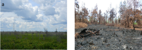
Figure 9. Peatland condition a) pre-fire and b) post-fire
3.3 The contribution of leadership on community
3.3.1 Leading actor
The main function of the leader is to help the group being led to be willing to learn to decide and work together more effectively and efficiently. Then, the role of a leader includes being a coach who can provide assistance to his community for better livelihood. Based on the results of the focus group discussions (FGDs), a trend from slash-burn to land cultivation without burning agriculture in Kalampangan was strongly supported by influential leadership provided by the government, academia and elders in the rural communities. The role of the three will be described in the following subsection.
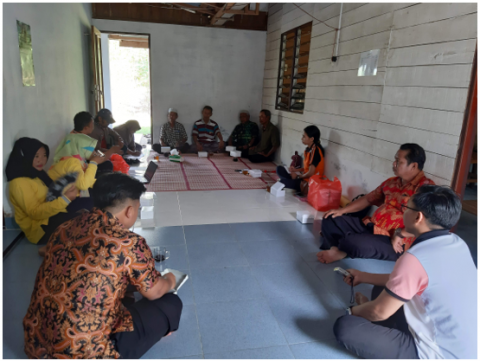
There are over 20 farmer groups in Kalampangan Village, with the number of members per group ranging from 17-35 people. Author conducted a focus group discussion with representative of community as shown in Figure 10. Among the farmer groups there are several group leaders who have influence over other farmers, namely Mr. Budiyana who initiates Honey Bee project, Mr. Joko Widodo who cultivates dragon fruit agrotourism, and Mr. Tamanurudin who campign for PLTB program [50].
Figure 10. A focus group discussion for community in Kalampangan Village
The leader of the group duties in village are: a) coordinating the implementation of group activity plans, b) leading group meetings and meetings, c) determining/deciding the results of the deliberation, d) representing the group in dealing with other parties, e) being responsible for finances and group activities, f) sign papers, either inward or outward g) encourage and encourage members. This type of community leader can inspire members and hold himself accountable for his actions.
The Indonesia Government’s strategic action plan for the peatland restoration in Central and West Kalimantan is implemented by the Regional Peat Restoration Team under the coordination of the Governor by involving the National Army, Police, Universities, Planning Agencies, Technical Unit of Ministry of FoE, Forestry Service, Agriculture Service, to field activities at the Regency/City, District and Village levels. Structurally and financially, this team is under the Provincial Environment Agency. Its duties are outlined in the 3R activities, namely: Rewetting, Revegetation and Economic Revitalization in peatlands in Central Kalimantan. One of the program was PLTB program or tillage without burning in collaboration with formal leaders in the village social structure as well as opinion leaders and innovators of land management without burning. In addition to farmer leaders, Restoration Team and Environment Agency considers the role of traditional leaders, community leaders, and religious leaders. To create homophilic conditions and improve communication effectiveness, BRG also involves field school participants and the younger generation [57]. Therefore, the leadership role of the local government is mostly on the policy level and should be improved in the future. It is a typical bureaucratic apparatus, following rules rigorously, and ensuring that people follow procedure.
The research and education sector, in this case the University of Palangka Raya (UPR), have initiated the contract farmer program. Centre For International Cooperation In Sustainable Management of Tropical Peatland (CIMTROP) UPR developed a pilot project of reforestation system innovation on degraded land called the Buying Living Tree System (BLTS), funded by Ehime University – Japan (2006 – 2008) and Siemenpuu Foundation from Finland (2008 – 2009). The project area is located south of the city of Palangka Raya and north of the city of Pulang Pisau in the so-called Kalampangan zone in the Ex-Mega Rice project area. In the BLTS/SBTT strategy, the government is encouraged to nominate this area as land owned and managed by farmers for at least 30 to 35 years. The area will be reserved for tree planting for the duration of the project, and after project closure the area will be managed by the farmers with assistance and guidance from CIMTROP. The BLTS/SBTT approach includes the involvement of local communities to improve the environment through nurseries after maintenance and maintenance, and thus have a longer scope of operation, instead of only planting a predetermined number of seedlings. Limin et al. [58] explained that the Living Tree Purchase System is a method that will provide direct benefits to the community. Based on this experiment, the percentage of live trees after one year was higher than using other methods. This method is not only for economic reasons, but also a strategy to educate and raise public awareness. The trees selected for planting are native to peat swamps and can adapt to acidic conditions. In Indonesia, university should apply, what we call “Tri Dharma Perguruan Tinggi” or three pillar of higher education leadership. One of them is the pillar of community service that can generate ideas, inspiration and development for the field of research and development, as well as form a humanist personality from the field of community service to the field of education and teaching. The more than 50 projects in collaborate with UPR concerning the conservation and utilization of peatland in Central Kalimantan [10].
3.3.2 Actions and programs to reduce the risk of land fires in sustainable peatland management
Table 3. Actions and programs in Kalampangan Village
|
A |
Recovery |
|
|
|
|
|
|
|
|
|
|
|
|
|
B |
Prevention |
|
|
|
|
|
|
|
|
|
|
C |
Program |
|
|
|
|
|
|
|
|
|
|
|
|
|
D |
Remark |
|
|
|
The findings of the FGD with the Kalampangan village community are displayed in Table 3. To lower the risk of fires and improve the sustainability of peatlands, numerous recovery, prevention, and program initiatives have been put in place. Many groups, including the government, academic institutions, and village leaders, support these initiatives. Collaboration is necessary to reduce peatland fires in Indonesia, but this is very challenging. The community of Kalampangan appears to be doing well with this. One indication that this is still a viable agricultural region is the fact that there aren't as many fires here as there are in nearby villages [59].
There is (3) three ways of farming in Kalampangan Village, namely vegetable farm, agroforestry and agro-tourism. The development of vegetable crops for livelihood has been carried out since 1990s, followed by the popularity of fruit-picking agro-tourism after 2015. The biggest challenge for the future of sustainable peat management is the annual forest and land fires. One of the reasons is the practice of land clearing with uncontrolled burning during the dry season. The most common impact is that floods become more frequent and peatlands become more vulnerable to repeated fires. Then, the local leadership is shown by the existence of several government programs related to peat restoration after the 2015 fires. The University of Palangka Raya through one of research centers, CIMTROP, has encourages peatland revegetation using the Buying Living Tree System method, which is widely followed by the community. The heads of the farmer groups in the village of Kalampangan have also become champions in the utilizing peatlands to revitalize the community's economy there.
Regarding the state of agricultural practices today in addressing the demands to increase productivity while also preserving the environment and natural resources, this study's lesson learned serves as one of references. Researchers and agribusiness players can use the findings to accommodate stakeholders and add value for degraded peatland. However, the scope of our study is restricted to local leadership in reducing fire risk due to ecological and environmental factors. Other sustainable standards and certification (Sustainability Standards and Certification/SSC) for Indonesia will be the subject of future study. Non-governmental organizations (NGOs) and businesses in the North (Western world) developed the majority of these standards, frequently in partnerships (businesses and NGOs, and between SSCs). Despite participation in the voluntary SSC scheme, SSC gradually becomes a requirement for farmers (developing countries from the South) to access global markets.
Great thanks to Chief of Kalampangan Village and local community who participated in this collaborative researches. The study partly funded by Ministry of Education, Culture, Research and Technology, Indonesia and Research Institute for Humanity and Nature, Japan. For publication is supported by Ministry of Agriculture, Forestry and Fishery, Japan (MAFF) contributes to CIFOR. We are grateful to editors and reviewers for their feedback.
[1] MacKinnon, K., Hatta, G., Mangalik, A., Halim, H. (1996). The ecology of Kalimantan, 3. Oxford University Press.
[2] Wadley, R.L. (2022). Histories of the Borneo environment: Economic, political and social dimensions of change and continuity. Brill. https://doi.org/10.1163/9789004454279
[3] Wahyunto, N.K., Ritung, S., Sulaeman, Y. (2014). Indonesian peatland map: method, certainty, and uses. Proceeding Lokakarya Kajian dan Sebaran Gambut di Indonesia, 81-96.
[4] Malaysia, W.I. (2010). A quick scan of peatlands in Malaysia. https://malaysia.wetlands.org/publications/a-quick-scan-of-peatlands-in-malaysia-2/, accessed on 11 Nov. 2022.
[5] Lupascu, M., Akhtar, H., Smith, T.E., Sukri, R.S. (2020). Post-fire carbon dynamics in the tropical peat swamp forests of Brunei reveal long-term elevated CH4 flux. Global Change Biology, 26(9): 5125-5145. https://doi.org/10.1111/gcb.15195
[6] Kobayashi, S. (2016). Peatland and peatland forest in Brunei Darussalam. In Tropical peatland ecosystems, 75-89. Springer, Tokyo. https://doi.org/10.1007/978-4-431-55681-7_5
[7] Putra, E.I., Hayasaka, H., Takahashi, H., Usup, A. (2008). Recent peat fire activity in the mega rice project area, Central Kalimantan, Indonesia. Journal of Disaster Research, 3(5): 334-341. https://doi.org/10.20965/jdr.2008.p0334
[8] Yulianti, N., Kusin, K., Naito, D., Kawasaki, M., Kozan, O., Susatyo, K.E. (2020). The linkage of El Niño-induced peat fires and its relation to current haze condition in Central Kalimantan. Journal of Wetlands Environmental Management, 8(2): 100-116. https://doi.org/10.20527/jwem.v8i2.221
[9] Page, S., Hoscilo, A. (2018). Fire in Borneo peatlands, The Wetland Book. Springer, Dordrecht, 65-71. https://doi.org/10.1007/978-90-481-9659-3_11
[10] Yulianti, N. (2021). An introduction of fire and transboundary haze disaster [Case study of ex-mega rice project in central Kalimantan]. PT Penerbit IPB Press.
[11] Dennis, R. (1999). A review of fire projects in Indonesia, 1982-1998. https://doi.org/10.17528/cifor/000564
[12] Harrison, M.E., Cheyne, S.M., Sulistiyanto, Y., Rieley, J.O. (2007). Biological effects of smoke from dry-season fires in non-burnt areas of the Sabangau Peat-Swamp Forest, Central Kalimantan, Indonesia. In The International Symposium and Workshop on Tropical Peatland “Carbon-Climate-Human Interactions-Carbon Pools, Fire, Mitigation, Restoration and Wise Use.” Yogyakarta, Indonesia.
[13] Putra, E.I., Hiroshi, (2011). The effect of the precipitation pattern of the dry season on peat fire occurrence in the Mega Rice Project area, Central Kalimantan, Indonesia. Tropics, 19(4): 145-156. https://doi.org/10.3759/tropics.19.145
[14] Heil, A., Goldammer, J. (2001). Smoke-haze pollution: A review of the 1997 episode in Southeast Asia. Regional Environmental Change, 2(1): 24-37. https://doi.org/10.1007/s101130100021
[15] Islam, M.S., Hui Pei, Y., Mangharam, S. (2016). Trans-boundary haze pollution in Southeast Asia: Sustainability through plural environmental governance. Sustainability, 8(5): 499. https://doi.org/10.3390/su8050499
[16] Davies, S.J., Unam, L. (1999). Smoke-haze from the 1997 Indonesian forest fires: effects on pollution levels, local climate, atmospheric CO2 concentrations, and tree photosynthesis. Forest Ecology and Management, 124(2-3): 137-144. https://doi.org/10.1016/S0378-1127(99)00060-2
[17] Van Der Werf, G.R., Randerson, J.T., Giglio, L., Van Leeuwen, T.T., Chen, Y., Rogers, B.M., Kasibhatla, P.S. (2017). Global fire emissions estimates during 1997-2016. Earth System Science Data, 9(2): 697-720. https://doi.org/10.5194/essd-9-697-2017
[18] Ramakreshnan, L., Aghamohammadi, N., Fong, C.S., Bulgiba, A., Zaki, R.A., Wong, L.P., Sulaiman, N.M. (2018). Haze and health impacts in ASEAN countries: a systematic review. Environmental Science and Pollution Research, 25(3): 2096-2111. https://doi.org/10.1007/s11356-017-0860-y
[19] Erb, W.M., Barrow, E.J., Hofner, A.N., Utami-Atmoko, S.S., Vogel, E.R. (2018). Wildfire smoke impacts activity and energetics of wild Bornean orangutans. Scientific Reports, 8(1): 1-8. https://doi.org/10.1038/s41598-018-25847-1
[20] Wasis, B., Winata, B., Marpaung, D.R. (2018). Impact of land and forest fire on soil fauna diversity in several land cover in Jambi Province, Indonesia. Biodiversitas Journal of Biological Diversity, 19(2): 690-696. https://doi.org/10.13057/biodiv/d190249
[21] Reddington, C.L., Yoshioka, M., Balasubramanian, R., Ridley, D., Toh, Y.Y., Arnold, S.R., Spracklen, D.V. (2014). Contribution of vegetation and peat fires to particulate air pollution in Southeast Asia. Environmental Research Letters, 9(9): 094006. https://doi.org/10.1088/1748-9326/9/9/094006
[22] Yulianti, N., Adji, F.F. (2022). Selayang Pandang Restorasi Gambut Pasca Karhutla Region Kalimantan. PT Penerbit IPB Press.
[23] Secretariat, A.S.E.A.N. (2020). ASEAN sustainable development goals indicators baseline report. ASEAN: Jakarta, Indonesia.
[24] Marwanto, S., Pangestu, F. (2021). Food estate program in central kalimantan province as an integrated and sustainable solution for food security in Indonesia. In IOP Conference Series: Earth and Environmental Science, 794(1): 012068. https://doi.org/10.1088/1755-1315/794/1/012068
[25] World Bank. (2021). Sustainable lowland agriculture development in Indonesia. World Bank. https://doi.org/10.1596/36223.
[26] Syuaib, M.F. (2016). Sustainable agriculture in Indonesia: Facts and challenges to keep growing in harmony with environment. Agricultural Engineering International: CIGR Journal, 18(2): 170-184.
[27] Surahman, A., Soni, P., Shivakoti, G.P. (2019). Improving strategies for sustainability of short-term agricultural utilization on degraded peatlands in Central Kalimantan. Environment, Development and Sustainability, 21(3): 1369-1389. https://doi.org/10.1007/s10668-018-0090-6.
[28] Afentina, Yanarita, Indrayanti, L., Rotinsulu, J.A., Hidayat, N., Sianipar, J. (2021). The potential of agroforestry in supporting food security for peatland community–a case study in the Kalampangan village, Central Kalimantan. Journal of Ecological Engineering, 22(8): 123-130. https://doi.org/10.12911/22998993/140260
[29] Maftu’ah, E., Susilawati, A., Hayati, A. (2019). Effectiveness of ameliorant and fertilizer on improving soil fertility, growth and yields of red chili in degraded peatland. In IOP Conference Series: Earth and Environmental Science, 393(1): 012011. https://doi.org/10.1088/1755-1315/393/1/012011
[30] Fahmi, A., Susilawati, A. (2020). The utilization of agricultural waste for peatland management; in case chili cultivation. In IOP Conference Series: Materials Science and Engineering, 980(1): 012069. https://doi.org/10.1088/1757-899X/980/1/012069
[31] Edison, M.N.F.E., Sukraini, N. (2020). Environmentally friendly and economically sustainable local peatland cultivation strategies. Sociae Polites, 21(2): 171-178. https://doi.org/10.33541/sp.v21i3.2247
[32] Kusuma, E.W.W., Maas, A., Utami, S.N.H., Maftuah, E. (2021). Effects of rice husk biochar and raised bed on CO2 flux and shallot (Allium cepa L.) production on peatland. SAINS TANAH-Journal of Soil Science and Agroclimatology, 18(2): 159-165. https://doi.org/10.20961/stjssa.v18i2.47974
[33] van der Meer, P.J., Tata, H., Rachmanadi, D., Arifin, Y. F., Suwarno, A., van Arensbergen, P. (2021). Developing sustainable and profitable solutions for peatland restoration. In IOP Conference Series: Earth and Environmental Science, 914(1): 012032. https://doi.org/10.1088/1755-1315/914/1/012032
[34] Tata, H.L., Nuroniah, H.S., Ahsania, D.A., Anggunira, H., Hidayati, S.N., Pratama, M., Kolka, R. (2022). Flooding tolerance of four tropical peatland tree species in a nursery trial. PloS One, 17(4): e0262375. https://doi.org/10.1371/journal.pone.0262375
[35] Takahashi, H., Yamamoto, K., Inoue, T. (2021). Principles of hydrological management of tropical peatland. Tropical Peatland Eco-management, 537-566. https://doi.org/10.1007/978-981-33-4654-3_19
[36] Yuwati, T.W., Rachmanadi, D., Qirom, M.A., Santosa, P.B., Kusin, K., Tata, H.L. (2021). Peatland restoration in Central Kalimantan by rewetting and rehabilitation with Shorea balangeran. In Tropical Peatland Eco-Management, 595-611. https://doi.org/10.1007/978-981-33-4654-3_21
[37] Jaya, A., Antang, E.U., Djaya, A.A., Gunawan, H. (2021). Agroforestry farming system as peatland restoration efforts in Central Kalimantan, Indonesia. In IOP Conference Series: Earth and Environmental Science, 694(1): 012016. https://doi.org/10.1088/1755-1315/694/1/012016
[38] Harun, M.K., Arifin, H.S., Anwar, S., Putri, E.I.K., Tata, H.L. (2022). Agroforestry approaches in the restoration of peatland landscapes in central Kalimantan, Indonesia. In Forest Dynamics and Conservation, 331-362. https://doi.org/10.1007/978-981-19-0071-6_16
[39] Yulianti, N., Hayasaka, H. (2013). Recent active fires under El Niño conditions in Kalimantan, Indonesia. American Journal of Plant Sciences, 4(3A): 685-696. https://doi.org/10.4236/ajps.2013.43a087
[40] Arvelyna, Y., Takahashi, H., Indrayanti, L., Hayasaka, H., Vadrevu, K.P., Maryani, R., Kazuyo, H. (2021). Peatland surface loss due to fires in central Kalimantan, Indonesia–a case study using differential interferometry SAR (DInSAR). In Biomass Burning in South and Southeast Asia, 77-90. https://doi.org/10.1201/9780429022258-5
[41] Kusin, K., Jagau, Y., Ricardo, J., Saman, T.N., Aguswan, Y. (2020). Peat lost by fire in Kalampangan area, Central Kalimantan, Indonesia. In IOP Conference Series: Earth and Environmental Science, 504(1): 012009. https://doi.org/10.1088/1755-1315/504/1/012009
[42] Schaafsma, M., Van Beukering, P.J.H., Oskolokaite, I. (2017). Combining focus group discussions and choice experiments for economic valuation of peatland restoration: A case study in Central Kalimantan, Indonesia. Ecosystem services, 27: 150-160. https://doi.org/10.1016/j.ecoser.2017.08.012
[43] Yulianti, N., Hoa, P., Jha, K., Awang, A. (2016). Sustainable highland development-a case of bundu Tuhan, Kundasang, Sabah, Malaysia. https://www.researchgate.net/publication/299411254_Sustainable_Highland_Development_-_A_Case_of_Bundu_Tuhan_Kundasang_Sabah_Malaysia.
[44] Sunaryati, R. (2019). Perception of peatland vegetables farmers on the development of sustainable agricultural systems in Kalampangan village, Sabangau district, Palangka Raya city. J. Agri Peat, 20(2): 99-106. http://e-journal.upr.ac.id/index.php/Agp/article/download/145/151.
[45] Rario, B., Kasto, K., Ritohardoyo, S. (2005). Persepsi dan perilaku petani dalam penanganan risiko pestisida pada lingkungan di kelurahan kalampangan, kecamatan sabangau kota palangka raya (Farmer’s perception and behavior toward the risk of pesticide to the environment in Kalampangan Village, Sabang). Jurnal Manusia dan Lingkungan, 12(1): 43-52. https://doi.org/10.22146/jml.18633
[46] Tata, H.L., van Noordwijk, M., Widayati, A. (2016). Domestication of Dyera polyphylla (Miq.) Steenis in peatland agroforestry systems in Jambi, Indonesia. Agroforestry Systems, 90(4): 617-630. https://doi.org/10.1007/s10457-015-9837-3
[47] Bastoni, M., Choirul Akhmad, M.E. (2014). Budidaya jelutung rawa (Dyera lowii Hook. F), Balai Penelitian Kehutanan Palembang. Available: https://www.forda-mof.org/files/jelutung_rawa.pdf
[48] Budiningsih, K., Effendi, R. (2013). Analisis kelayakan finansial hutan tanaman jelutung (Dyera polyphylla) di Kalimantan Tengah. Jurnal Penelitian Hutan Tanaman, 10(1): 17-23. https://doi.org/10.20886/jpht.2013.10.1.17-23
[49] Wati, H., Azwar, F. (2009). Gulma penting pada lokasi penanaman beberapa jenis lokal di Sumatera Selatan in Prosiding seminar hasil-hasil penelitian balai penelitian kehutanan, mengenal teknik budidaya jenis-jenis pohon lokal sumsel dan upaya Pengembangannya”, 2009(0711): 189-193. https://123dok.com/document/yj7491em-prosiding-diterbitkan-penelitian-pengembangan-tanaman-penelitian-pengembangan-kehutanan.html.
[50] Yulianti, N., Adji, F.F. (2018). Mari belajar tentang pengelolaan lahan tanpa bakar (PLTB). Penerbit IPB Press. Available: https://books.google.co.id/books?id=3uIszQEACAAJ
[51] Aldrian, E., Dwi Susanto, R. (2003). Identification of three dominant rainfall regions within Indonesia and their relationship to sea surface temperature. International Journal of Climatology: A Journal of the Royal Meteorological Society, 23(12): 1435-1452. https://doi.org/10.1002/joc.950
[52] Lestari, A., Rumantir, G., Tapper, N., Saharjo, B.H., Usup, A., Graham, L., Teguh, R. (2018). Analysing causal factors of peatland wildfires: A knowledge-based approach. In Pacific Asia Conference on Information Systems 2018: Opportunities and Challenges for the Digitized Society: Are We Ready? 276. https://aisel.aisnet.org/pacis2018/276/
[53] Citranu. (2020). Implementation of the adat dayak criminal sanctions (singer / fine) against the perpetrators of burning forests and land in the Central kalimantan region. eL-Mashlahah, 10(1): 64-78. https://e-journal.iain-palangkaraya.ac.id/index.php/maslahah/article/download/1786/pdf.
[54] Syaufina, L., Ainuddin, A.N. (2011). Impacts of fire on Southeast Asia tropical forests biodiversity: A review. Asian Journal of Plant Sciences, 10(4): 238-244. https://doi.org/10.3923/ajps.2011.238.244
[55] Yulianti, N., Kusin, K., Murni, E., Barbara, B., Naito, D., Kozan, O., Susetyo, K.E. (2020). Preleminary analysis of cause-effect on forest-peatland fires prior to 2020 in Central Kalimantan. Ecotrophic, 14(1): 62-73.
[56] Sazawa, K., Syawal, M.S., Kuramitz, H., Saito, T., Hosokawa, T., Kurasaki, M., Tanaka, S. (2016). Peat fire impact on water quality and organic matter in peat soil. In Tropical Peatland Ecosystems, 281-296. https://doi.org/10.1007/978-4-431-55681-7_18
[57] Anggraini, R.D. (2020). Difusi inovasi pengolahan lahan basah tanpa bakar di kalimantan tengah. Jurnal Penelitian Pers dan Komunikasi Pembangunan, 24(1): 518651. https://doi.org/10.46426/jp2kp.v24i1.113
[58] Limin, S.H., Rieley, J.O., Ritzema, H.P., Vasander, H. (2008). Some requirements for restoration of peatland in the former Mega Rice Project in Central Kalimantan, Indonesia: blocking channels, increasing livelihoods and controlling fires. Restoration of Tropical Peatlands, 223-229.
[59] Akbar, A. (2022). Lesson learned from the 2019 peatland fire in Tumbang Nusa Area, Indonesia. In IOP Conference Series: Earth and Environmental Science 959(1): 012054. https://doi.org/10.1088/1755-1315/959/1/012054