Bambang Wicaksono* | Ari Siswanto | Widya Fransiska Febriati Anwar | Susilo Kusdiwanggo
© 2022 IIETA. This article is published by IIETA and is licensed under the CC BY 4.0 license (http://creativecommons.org/licenses/by/4.0/).
OPEN ACCESS
The growth of settlements on the banks of the Musi River, Palembang as a center of trade and government cannot be separated from the existence of rivers and their flows which then change the morphology of the riverbanks. The morphological development of the city formed as a result of riverbank reclamation is strongly influenced by endogenous and exogenous forces. Physical development by the community that is not in harmony with the river causes environmental problems that affect the quality of the residential environment. The research method uses a qualitative case study approach to explore information on the reality of the field in the research area. Each segment is analyzed for settlement growth which is formulated into four categories and then produces a theme. Overall, the morphology of the settlement growth of the Musi Riverside is in two patterns, namely with urban growth where the riverside settlement area has a cluster and linear pattern that has an impact on the economic growth of the settlement and is not in harmony with the morphology of the riverbank with all its mixing activities. Furthermore, linear growth, where the growth of suburban settlements is only concentrated in areas that provide road access, and riverside land is still a water catchment area.
settlement, morphology, riverside, growth, Musi of Palembang
One of the manifestations of ethnic culture is the life of riverside community groups. The growth and development of a settlement as a center of trade and government cannot be separated from the existence of a river and its flow at the beginning of its formation. In the study of riverside settlements in Palembang, Palembang city is one of the river cities that was born from the development of settlements in riverside areas, namely the Musi River and its tributaries [1]. The city is the center of creativity, the city is also a place for humans to carry out activities where the overall importance of regular mobility and access to the city for residents in the suburbs. Regular mobility is an ingrained part of people's livelihood strategies. The majority of households depend on one or more members who regularly travel to the central part of the city in relation to their livelihood activities [2]. This reflects the vitality and opportunity of the community to develop socio-economic progress which is supported by the potential of a city, one of which is a river [3]. For example, the life of the people of Banjarmasin City which rooted in the river and the magnitude of the influence of the river in the formation of the city was not enough be a driving and directing factor change/development of the city in a better direction good. Riverside settlements, as a forerunner the formation of the city of Banjarmasin [4]. The limited land for settlement and the high level of competition for land use in the city of Palembang resulted in the shift of land use from riverside settlements to land-based settlements. As a result, in the riverside areas, scattered settlements resulted in the houses being disorganized and disintegrating with each other. The development of the morphology of the city formed in the riverside reclamation area. Changes in the shape of the city due to reclamation are strongly influenced by two forces, namely endogenous forces in the form of community social structures, beliefs, ways of life and exogenous forces, namely the existence of policies in shaping the built environment [5].
At first, the community chose an area to live in an area that guaranteed their needs and was in harmony with river life. However, due to increasing population growth and the limitations of the community's economy to choose a place to live, this results in the inappropriateness of the area where they live [5]. Some settlements or old houses in settlements were left by the original inhabitants abandoned because they had the economic capacity to move to new housing or migrated out of the area. It can be stated that the population cannot adapt to the environment. Meanwhile, their houses attract residents with weak economies to occupy them with limited economic resources, as a result they are unable to repair damaged buildings and settlement networks. This condition affected all settlements [6]. In addition, the growth of this settlement also has an influence on changes in the morphology of the riverside area in it. Changes in physical development and land use can cause various problems, one of which is the problem of the residential environment, which of course also affects the quality of the residential environment [7]. The physical development of the city can be identified based on the area built, which is mostly used as a residential area. Riverside settlements are areas that are dominated by an aquatic environment supported by riverside infrastructure, environmental facilities and workplaces. Losses arising from the irregular growth of settlements, especially in the city center, can cause a decrease in the quality of rivers and settlements themselves. Where the growth in the number of dwellings can close the space for water to move, the density of these settlements is also the cause of the slums of the river environment. In the context of the riverside residential environment, the quality of settlements decreases or is not visible from the development of residential areas which are more oriented towards achieving quantity targets [8].
This study focuses on changes in the morphology of the riverside area caused by the growth of urban settlements. Where the results show changes because the growth of settlements affects the morphology of the settlements, namely the shape of the house, the function of space, and the shape of the settlement environment towards the river. The morphological changes that occur today can be categorized into two, namely (1) physical changes that eliminate the architectural character of the riverbanks (2) changes that adjust for environmental improvement according to the socio-economic conditions of the community. Change creates reciprocity between humans and rivers, although rivers tend to receive negative effects from the changes that occur.
2.1 Morphology of riverside settlement
The presence of water causes the formation of an elongated waterfront settlement pattern along the water's edge, coastal settlements surround the waters and coastal settlements follow the physical shape of the waters [9]. The influence of settlement growth on settlement morphology typologically occurs at the location:
2.1.1 Morphology of settlements to land
These settlements were formed on the banks of the river and then developed towards the mainland to form residential groups. This shape is influenced by the topography of the waters. At first the housing faced the river, then changed to face the access that was formed like a road and even formed a new settlement network. There are two basic substances related to population growth, namely the spatial conflict between humans and water, namely: First, the population increases, the need for land (built space) increases and the need for water increases. Second, the availability of water decreases because the water container (in green open spaces) decreases and water absorption in the recharge area also decreases [10]. increasingly dense settlement growth and difficulty in accessing settlements on the banks of the Musi River. Overall, the increasing population growth and limited land for settlements on the banks of the Musi River are the reasons for building in the river border area. Meanwhile, humans and society (man and society) experienced growth which made the density of settlements on the banks of the Musi River. There are 3 patterns of occurrence of riverside settlements, the first is the pattern of land communities who occupy river land. The second is changing the orientation of living in rivers to non-rivers. The three dominant land settlements. Changes that occur in the form of building materials, building structures in the form of facades, spatial organization, orientation and achievements due to the declining quality of the Musi River, silting processes, slums, increasingly dense settlements.
2.1.2 Morphology of settlements to the river
This settlement pattern leads towards the waters, starting with the formation of houses on the water's edge and then developing towards the water to form residential groups. This morphology occurs due to the density of buildings on the coast or plains so that settlements develop towards the waters. However, in settlements in Palembang, this is actually the opposite, the number of dwellings that lead to the river is even less. The houses that were once built on water are now mostly pulled over and made on stilts, some have even been demolished. This typology describes the area of the river bank as more desirable as a place to build, as well as the difficulty of access to the river. Settlement growth can be understood more clearly through changes in containers, in nature, shelter and networks. In particular the shell element as it is the most visible. With the following observations on the growth of containers can understand the phenomenon as well as related to content, people and society, as well as the total balance between content and containers [6].
2.1.3 Morphology of settlements is unidirectional
This unidirectional morphology indicates that there is an indication of damage to the watershed, which makes the community try to create a new network. The engineering efforts that have been made can be said to be insignificant. Very large funds have been spent by the Government to build water infrastructure systems for various purposes. However, floods, landslides and droughts still occur throughout the year and tend to increase. The most dominant cause of flooding is the conversion of land that was previously green open space or forest area into a built space, especially housing as the population continues to grow. The government's efforts to control flooding, especially with the structural method, will be outpaced by the level of damage to watersheds due to changes in land use, which consequently increases even though water infrastructure has been built at a cost.
2.1.4 Morphology on the riverside
The presence of water causes the formation of a waterfront settlement pattern along the water's edge, coastal settlements surround the waters and coastal settlements follow the physical shape of the waters [9]. The uncontrolled growth of settlements and the presence of some natural limitations cause serious problems in carrying capacity and environmental quality [11].
2.2 Urban riverside settlement
The process of urbanization pressure on settlements tends to diminish the traditional values of waterfront housing [12]. The spatially intensive development of rural settlements has become an important power, which is driving the current new-type urbanization [13]. The neglect of river layout makes the river no longer the orientation and location of residential houses due to the development of the city towards the mainland. The condition of the riverside residential area which had previously been neatly arranged during the sultanate has now become a dense and irregular area and is known to be quite vulnerable both socially, culturally and environmentally. With the development of land transportation networks, river transportation is not considered the main thing. This condition leads to a transformation process that is not in accordance with the natural cultural conditions of the river and decreased attention to riverside areas, then decreased quality of life in riverside areas.
In settlements in Palembang, changes occur in the center of settlements due to pressure from increasing population and mixing activities of riverside settlements on land. This is what makes people try to build settlements in the river border area and close the swamp area, because it is a public area or unused land. Overall, the settlements on the banks of the Musi River in Palembang have undergone changes and growth from vernacular settlements to urban settlements.
The process of urbanization pressure on settlements tends to diminish the traditional values of waterfront housing [12]. The neglect of river layout makes the river no longer the orientation and location of residential houses due to the development of the city towards the mainland. The condition of the riverside residential area which had previously been neatly arranged during the sultanate has now become a dense and irregular area and is known to be quite vulnerable both socially, culturally and environmentally. With the development of land transportation networks, river transportation is not considered the main thing. This condition leads to a transformation process that is not in accordance with the natural cultural conditions of the river and decreased attention to riverside areas, then decreased quality of life in riverside areas.
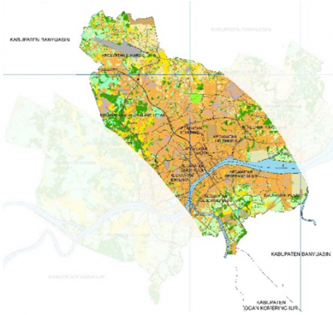
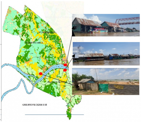
In settlements in Palembang, changes occur in the center of settlements due to pressure from increasing population and mixing activities of riverside settlements on land. This pressure makes the population's housing needs increase. This is what makes people try to build settlements in the river border area and close the swamp area, because it is a public area or unused land. Overall, the settlements on the Riverside Musi in Palembang have undergone changes and growth from vernacular settlements to urban settlements. Urban riverside settlement area can be seen in Figure 1.
Figure 1. Urban riverside settlement area in Palembang
From the map description in Palembang City above, it shows the rapid flow of urbanization from various areas in the center of Palembang City, with various cultural backgrounds, and the unclear regulations that exist now make settlements on the banks of the Musi River increasingly dense and irregular, while the residents themselves continue to build on land that is a water catchment area and even build in a tributary area in a settlement.
2.3 Urban sprawl settlement
Urban sprawl is defined as the emergence of low density residential and other commercial facilities on undeveloped land [15]. Urban activities that have an impact on physical changes, such as the conversion of agricultural land into built-up land, are found in the transition zone. The expansion of urban areas and the increasing number of people entering suburban areas have changed land use, especially in urban border areas [8]. There are factors that influence the growth of suburban areas, namely First, an increase in transportation services so as to facilitate community mobilization to the city center, Second, the movement of people from the city center to suburban areas, Third, increasing the standard of living of the community.
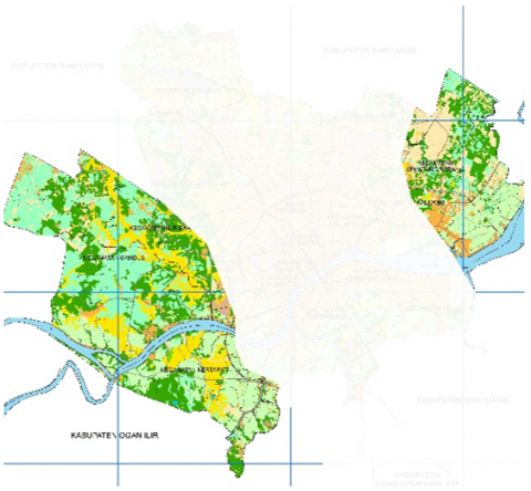
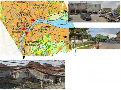
Urban sprawl generally occurs in big cities, one of which is in the settlements on the banks of the Musi River in Palembang. Urban sprawl in settlements in Palembang is a suburban area. The conversion of residential land functions is increasing every year and cannot be avoided due to rapid population growth, both from community kinship and community migration, as well as the increasing demands of community needs for land [14]. These kinds of place understanding reflect ontological relationships developed between people, nature and their designs (settlements) rather than as traditional or modern [16]. The limited land in Palembang City Center causes the development of the city to spread to other surrounding areas, one of which is in the upstream and downstream areas of the Musi River Palembang. Changes in land use along the Musi River, with the conversion of land use along the river border into built-up land. Urban sprawl riverside settlement area in Palembang can be seen in Figure 2.
Figure 2. Urban sprawl riverside settlement area in Palembang
This research uses a case study research strategy with multiple case studies. Case study as an approach to the location of settlements on the banks of the Musi River which was adopted in collecting information on the influence of growth on changes in settlement morphology. Case study research examines the characteristics of a few cases. These characteristics include the outskirts of the city which is a residential and industrial area as well as the characteristics of the city center which tends to be residential, trade and government.
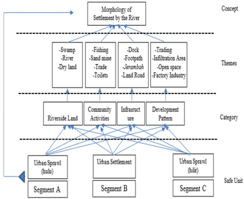
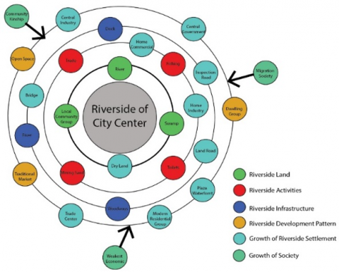
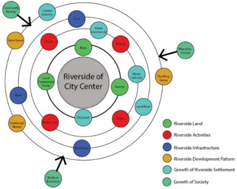
Primary data was collected by field observations, observations, and interviews, while secondary data was collected by literature studies, and observations on satellite image maps. This study divides the research area into three segments as the unit of observation, namely Segment A in the Ulu urban sprawl, Segment B in the urban settlement center and Segment C in the Ilir urban sprawl. This aims to see changes in the morphology of riverside settlements in the downtown area and the outskirts of the city. Each segment will be analyzed by case studies related to settlement growth which are formulated into four categories, namely, (1) riverside land, (2) Community Activities, (3) Infrastructure, (4) Development Patterns, then grouped to produce morphological themes of growth settlements include swamps, rivers, land, sand mining, fishing, trading, toilets, docks, trails, rafters, land roads, trade, absorption areas, open spaces, industrial factories. Furthermore, the morphological concept of settlement growth is known from each segment. The research flow can be seen in Figure 3.
Figure 3. Flowchart research
4.1 Research area and morphology of riverside
The research area is located in Palembang City, namely in settlements along the upstream and downstream banks of the Musi River Palembang. The location selection was based on the form of settlement growth in the upstream and downstream parts of the Musi River which tended to be low and in the dense and irregular city center. The research area is divided into three segments, where segment 1 is the outskirts of the city of Palembang in the west, segment 2 is the area in the center of the city of Palembang, and segment 3 is the suburbs for the eastern part of the city of Palembang. however, the research area is focused on the riverbank area with a boundary of approximately one kilometer from the Musi River in Palembang. This is limited because the focus of the research is on changes in the morphology of the riverside area due to the growth of urban settlements. Map of the research area can be seen in Figure 4.
Figure 4. Map of the research area on the Musi riverside Palembang
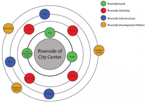
Riverside settlements in Palembang were originally formed by community groups or population groups in the Ilir and Ulu areas of Palembang City. Settlement groups are generally caused by ethnic groups, social class, and the ability to access land to build houses. The riverside community is currently inhabited by various cultural tribes that have been acculturated into a riverside culture. The morphology of settlements on the banks of the Musi River grows through four aspects, namely land, activities, infrastructure, and development patterns. The grouping can be seen in Figure 5.
Figure 5. Morfologi permukiman tepi Sungai Musi
4.2 Settlement segment 1
The settlements in segment 1 of the research location are in the western area of the city of Palembang. In the Seberang Ilir area, segment 1 is limited from the Ward of 36 Ilir to the Subdistrict of Gandus, while for the Seberang Ulu area it is limited from the Ward of 1 Ulu to Watd of Kertapati Palembang. The morphology of riverside settlements in the segment 1 area, the land use of this riverside land is approximately 60% which tends to be swamps and vacant lands. Segment 1 of the research location can be seen in Figure 6.
Figure 6. Research area map segment 1
The morphology of the settlements in segment 1 is an area with low residential and population intensity. The growth of settlements in this area tends to be linear along the riverside land route. This is due to the lack of government land ownership, community activities, infrastructure, and regional development. Community activities in this area still utilize the river, namely the many riverside sand mining activities. In addition, there is still a lack of regional infrastructure due to the distance of access from the city center. Regional infrastructure facilities in segment 1 already have a land route which is the access to this area on the riverside in Seberang Ulu and Seberang Ilir, Palembang City. In addition to road, this area can still be accessed via the river with the infrastructure of traditional piers and piers. Linear settlement pattern can be seen in Figure 7.
Figure 7. Linear settlement pattern on the Riverside Musi Palembang
The pattern of regional development is also still in the form of community dwellings (land houses and raft houses), and there are still many water catchment areas. Overall, the morphology of the settlement growth on the Riverside Musi Palembang in segment 1 is linearly patterned along the riverside road, low-intensity residential density, and still has floodplains and natural river conditions. Morphologically, the growth of riverside settlements in segment 1 can be seen in Figure 8.
Figure 8. The pattern of residential growth in segment 1 on the Riverside Musi Palembang
4.3 Settlement segment 2
The settlements in segment 2 of the research location are the downtown area of Palembang. In the Seberang Ilir area, segment 2 is limited from the Ward of 35 Ilir to Ward of Kuto Batu, while the Seberang Ulu area is limited from Ward of 1 Ulu to Ward of 15 Ulu Palembang. The morphology of riverside settlements in the segment 2 area, this riverside land use tends to be a densely built area. Segment 2 of the research location can be seen in Figure 9.
Figure 9. Research area map segment 2
The morphology of the settlements in segment 2 is the central area of Palembang City with the intensity of buildings and dense population. The growth of settlements in this area tends to be uncontrolled, so that it almost no longer has a river floodplain area. Land use, community activities, infrastructure facilities, and the development of riverside residential areas are highly considered and continuously updated. Various kinds of community activities in this segment 2 area tend to be on land, while river activities are only for those who will cross, riverside tourism, and trade.
In addition, the area's infrastructure is very good and very supportive of the riverside settlements. Access to settlements tends to use land routes. Where the carrying capacity of the infrastructure to connect Seberang Ulu and Seberang Ilir can be through bridges, namely the Ampera Bridge, Musi 2 Bridge, Musi 4 and Musi 6. The pattern of regional development is very densely populated and populated. In fact, most of the settlements in Seberang Ulu and Seberang Ilir no longer have floodplains or infiltration areas. The Seberang Ulu Settlement in segment 2 has riverbank development dominated by community dwellings building on river land, and even building houses on rivers with massive structures. This residential community group builds housing that is no longer in harmony with the concept of riverside housing, but rather an adjustment to dry land, which is characterized by land dwellings. Meanwhile, in the Seberang Ilir area, the pattern of riverside development tends to be more programmed. This is because the segment 2 area in Seberang Ilir is the center of Palembang City, where the area is the center of government, trade center, and industrial center. While the pattern of riverside development is trade, piers for tourism or crossing, waterfront plazas, and community dwellings.
The results of the analysis show that the morphology of the growth of the Musi Riverside settlements in the city center in segment 2 occurs because (1) The downtown riverside has growing infrastructure (2) The city center riverside becomes a trading center that is able to support the community's economy (3) The central riverside is the center of government. (4) Availability of downtown riverside land that does not have legality. These factors trigger community groups from various backgrounds to live on the banks of the river. The growth of riverside communities in the center of Palembang City, is a group of migration communities, local communities, kinship communities, economically weak communities. These communities then try to get land in the city center even though it is located on the banks of the river. Riverside settlements grow uncontrollably, this is what makes the morphology of riverside settlements in the city center become dense and slums occur. With the condition of the riverside which is densely built, the morphological movement of settlement growth tends to depend on life in a land environment that is able to meet the needs of its people.
The pattern of settlement growth in segment 2 can be seen in Figure 10.
Figure 10. The pattern of settlement growth in segment 2 on the Riverside Musi Palembang
Overall, the morphology of the growth of settlements on the banks of the Musi River in Palembang in segment 2 is a high-density area with all the mixing of activities in it, especially in settlements on the Riverside Musi which tend to be urban.
4.4 Settlement segment 3
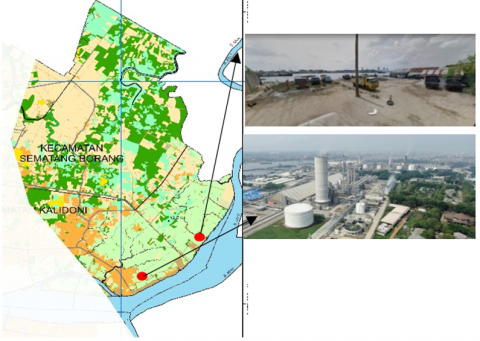
The settlements in segment 3 of this research location have almost the same morphology as the research location in segment 1, which is a residential area on the outskirts of the city. This settlement is an area east of Palembang City. In the Seberang Ilir area, segment 3 is limited from the Ward of Kuto Batu to Ward of Mata Merah, while the Seberang Ulu area is limited from the Ward of 15 Ulu area to Ward of Plaju Ilir. The morphology of the riverside settlements in the segment 3 area, the land use of this riverside land is less than 50%, tends to still be swamps and vacant lands which are lands for state-owned industrial factories (Pupuk Sriwijaya and Pertamina). Segment 3 research locations can be seen in Figure 11.
Figure 11. Research Area Map segment 3
The morphology of the settlements in segment 3 is an area on the edge of Palembang City with low building and population intensity. The growth of settlements in this area tends to be low, due to the legality of land ownership. Land use, community activities, infrastructure, and regional development tend to be limited because they are areas of factories that have an impact. Community activities in this segment 3 area tend to be on land and in rivers.
Figure 12. The pattern of settlement growth in segment 3 on the Riverside Musi Palembang
Table 1. Morphology of settlement growth in the area along the Musi River Palembang
|
Area |
Land of Riverside |
Community Activity |
Infrastructure |
Development Pattern |
|
Segment 1 |
Dominate Swamp and vacant land |
-Mining sand |
-Land Road -Jerambah (concrete ways) -Traditional Pier |
-Brich dwelling – Raft dwelling |
|
Riverside density <50% |
-Toilets |
|
Green line/water catchment |
|
|
Segment 2 |
Padat bangunan hunian |
Trade |
Land Road |
Trade Center |
|
Ruang terbuka non hijau |
Recreation |
Amprea Bridge, Musi IV, Musi VI Dock |
Central Government |
|
|
Riverside density >75% riverside dwelling |
Fishing Work at office |
|
Central Industry |
|
|
Segment 3 |
Swamp |
Trade |
Land Road |
Brich dwelling |
|
|
Work |
Inspection Road |
Factory Industry |
|
|
|
Factory Production |
Dock |
|
|
|
Riverside density <50% |
|
Inspection Road |
|
|
|
|
|
Plaza Waterfront |
|
The results of the analysis show that the regional infrastructure is very good and very supportive of the riverside settlements. Access to settlements tends to use land routes. Most of the settlements in Seberang Ulu and Seberang Ilir in this segment 3 area still have floodplains or infiltration areas. Seberang Ulu Settlement in segment 3 is the development of settlements for community dwellings located 500-800 meters from the Riverside Musi. Meanwhile, the Seberang Ilir area has the same pattern of riverside development as Seberang Ulu. This is because the riverside area is a development area for industrial factories. Overall, the morphology of the growth of the settlements along the Musi Palembang River in segment 3 is a low-density area where most of the area is privately owned by state-owned enterprises. Morphology, the growth of riverside settlements in segment 3 can be seen in Figure 12.
From the three segments of the research area, morphological themes of settlement growth can be formulated based on the four categories of the Musi River bank area which are arranged in Table 1.
The results of these themes can be crystallized into a morphological concept of the growth of the settlements on the banks of the Sungi Musi Palembang by (1) urban growth (2) linear growth. Urban growth means that the growth of riverside settlements in the downtown area is irregular and has characteristics that are not in harmony with the morphology of the riverbanks. Even river land is also a development area with all the mixing of activities. While linear growth means that regional growth is only centered on areas that provide access, where river land areas are still water catchment areas.
The growth of settlements has an influence on changes in the morphology of the Palembang Musi River bank area. Physical development by the community that is not in harmony with the river causes various problems, one of which is the problem of the residential environment that affects the quality of the residential environment. It was concluded that the morphology of the settlement growth on the banks of the Musi River in segment 1 was linear growth because the growth pattern was only on the axis of the riverside land road, while more than 75% of the land use was still in the form of vacant land or water catchment areas. In segment 2, the growth morphology is a combination growth (cluster and linear) which tends to be irregular, this growth is due to the dynamics of the population who tend to want to get land in urban areas and the ease of access. This growth gives a negative response to the river. Where almost 90% of the land which is a river area has become built up land. Meanwhile, the morphology of settlement growth in segment 3 has a linear pattern of settlement growth. The difference with the settlement growth in segment 1, the pattern of settlement growth in this area starts from 500-800 meters from the river, because it is a special area where 50% is land for the construction of state-owned factories. Overall, the morphology of the settlement growth on the banks of the Musi River occurs in a cluster and linear manner along the river, where the center of Palembang City is the growth with the highest intensity. This growth has changed the image of Palembang City from vernacular riverside settlements to urban riverside settlements. This research mostly formulates the morphology of settlement growth from the pattern of movement of dwellings or buildings. Future research can be more specific about growth because of the influence of community activities.
We would like to thank Universitas Indo Global Mandiri Palembang for providing permission and assistance to carry out this research. Then, thank you also to co-authors from the Architecture Study Program of Universitas Sriwijaya and Universitas Brawijaya who have contributed to provide input in this research.
[1] Purnama, S. (2014). Identification of physical architecture of the Musi riverside ethnic residential area in Palembang City based on regulatory aspects. Agreement No: III/LPPM/2014-03/30-P. Universitas Katolik Parahyangan.
[2] Andreasen, M.H., Møller-Jensen, L. (2017). Access to the city: Mobility patterns, transport and accessibility in peripheral settlements of Dar es Salaam. Journal of Transport Geography, 62: 20-29. https://doi.org/10.1016/j.jtrangeo.2017.05.005
[3] Daskalova, D., Slaev, A.D. (2015). Diversity in the suburbs: Socio-spatial segregation and mix in post-socialist Sofia. Habitat International, 50: 42-50. https://doi.org/10.1016/j.habitatint.2015.07.007
[4] Mentayani, I. (2019). Identity and existence riverside settlement of banjarmasin. Prosiding Seminar Nasional Lingkungan Lahan Basah, 4: 497-502.
[5] Wawan, R. (2014). Definition of change and social disorganization. Modul 1.
[6] Doxiadis, C.A. (1968). Ekistic, an introduction to the science of human settlements. London: Hutchinson of London.
[7] Oktarini, M.F. (2018). The settlement morphology along the Musi River. International Journal of Built Environment and Scientific Research, 2(2): 97-104.
[8] Mardiansjah, F.H. (2020). The development of a small urban place on the outskirts of Pekalongan city. 20: 151-168.
[9] Maclaren, V.W. (1996). Urban sustainability reporting. Journal of the American Planning Association, 62(2): 184-202. https://doi.org/10.1080/01944369608975684
[10] Kodoatie, R.J., Widiarto. (2016). Maintain water sovereignty. Yogyakarta: Paradigma. Chicago Style.
[11] Nugroho, S. (1999). Traditional estuary settlement of sungsang area south sumatera in vernaculat settlement: The role of local knowledge in built environment. Proceeding Universitas Indonesia, Depok.
[12] Prayitno, B. (2003). Culture-based riverside settlement arrangement model for living in the city of water. Proceeding Universitas Indonesia: Jakarta.
[13] Nogroho, I.S. (2022). The urban sprawl phenomenon on the factors of land use change in the outskirts of the city. Journal of Urban Regional Planing.
[14] Prihatin, R.B. (2015). Land function transfer in urban areas (Case study in Bandung and Yogyakarta Cities). Jurnal Aspirasi, Pusat Pengkajian, Pengolahan Data dan Informasi Sekretariat Jenderal DPR RI.
[15] Wang, J., Zhao, J. L., Wu, T.Y., Tang, L.K. (2017). New-type intensive rural settlements in China based on the unified and self-construction mechanisms of spatial organization. International Journal of Sustainable Development and Planning, 12(6): 1073-1084. https://doi.org/10.2495/SDP-V12-N6-1073-1084
[16] De Silva, W. (2017). Nature and buddhist architecture: Sri Lanka. International Journal of Design & Nature and Ecodynamics, 12(2): 225-234. https://doi.org/10.2495/DNE-V12-N2-225-234