Devianti* | Sri Haryani | Agus Arip Munawar | Dewi Sartika Thamren
© 2022 IIETA. This article is published by IIETA and is licensed under the CC BY 4.0 license (http://creativecommons.org/licenses/by/4.0/).
OPEN ACCESS
Agricultural problems that often arise are due to a lack of suitable and strategic agricultural land for its use, which results in poor agricultural production in the area. A land potential index that classifies existing land potentials from high to low class can be used to overcome this. This study aims to build an agricultural land potential index using a geographic information system in the Regency of Aceh Tengah, Indonesia, using a geographic information system. The method used in this research is a survey approach to collect information in the form of rainfall data, slope, lithology, soil type, land use and administrative maps of the Aceh Tengah Regency. The land potential index is obtained by overlaying the slope parameters, lithology, soil type, hydrology, and susceptibility to erosion into a land map unit that can classify it into five classes of a land potential index. The results of this study indicate that the Regency of Aceh Tengah is included in the very wet climate type. Maximum erosion was 1,213.6 tons per ha per year. The land potential index with very low criteria was 23.38% (102,002.42 ha) with a slope greater than 40%. The land potential index with very high criteria has an area of 3,807.80 ha (0.87%) with a maximum slope of 15%. A land potential index with very high criteria was found in the Linge, Atu Lintang, Lut Tawar, Pegasing, Bintang, Jagong Jeget, Kebayakan, Ketol, and Celala districts with an area of 2,014.26 ha, 1,266.33 ha, 174.81 ha, 148.07 ha, 77.86 ha, 73.63 ha, 46.77 ha, 4.14 ha and 1.94 ha, respectively. Meanwhile, the land potential index with very low criteria is found in all districts except Kute Panang and Atu Lintang.
Aceh, agricultural technology, appropriate technology, land potential index, GIS
The province of Aceh, Indonesia, has great potential in the agricultural sector. The agricultural sector in Aceh province has great potential for rapid growth. Based on the general description, the province of Aceh has an area of 397,512 ha of productive rice fields, 139,049 ha of dry land agriculture, 1,001 ha of plantations, 36,597 ha of ponds, 2,270 ha of forest, and 232 ha of grassland [1]. Agricultural resources in Aceh province are scattered in the Regency of Subulussalam, Singkil, Lokop City, and Pulau Banyak. Potential plantation and forest products are spread over several areas, including Krueng Jreu, Krueng Baro, Seulimum and Takengon.
The decrease in agricultural land from time to time and the suitability of land use that is less attention to result in agricultural production that is not good and not optimal. The land potential index can be one solution to these agricultural problems . The land potential index has land characteristics in the form of topography, such as various slopes, soil types, rock types, and rainfall, which are used to obtain land that has potential for agricultural land. Land with potential for agricultural cultivation has criteria such as having a flat topography with a slope of less than 3%, very low to low erosion sensitivity, deep effective depth, good water retention capacity, responsive to fertilization, and suitable for climate.
A land potential index is an activity that classifies existing land potentials into specific classes, from high to low class. From this, information will be generated on the best potential that can be optimally used in the land and provide the appropriate information on the supporting technology . The land potential index can be determined through several parameters such as slope maps, hydrological maps, soil maps, lithological maps, disaster risk maps, and agricultural land use maps. Determining the land potential index will be more efficient if presented in spatial data. The boundaries of each potential land can be known with certainty in its spatial pattern and, most importantly, in its absolute position. Therefore, an efficient method is needed to process and analyze spatial and attribute data to create a land potential index map.
A geographic information system is a device that helps in data storage, processing data, analyzing data, managing data, and presenting the information. Geographic information systems can be used to create a map of the land potential index of an area and can then be managed according to its long-term function. Geographic information systems have been widely used in agriculture . To date, there have been no research results reporting the use of this geographic information system in providing spatial data on land use indexes in the regency of Aceh Tengah. This is very much needed because the area has complex land characteristics ranging from very steep slopes to sloping land topography. Therefore, this study aims to build an agricultural land potential index using a geographic information system in the regency of Aceh Tengah, Indonesia. The results of this study are expected to help related parties and stakeholders in the Aceh Tengah regency manage their land use, primarily agricultural land, to maximize land use in their area.
2.1 Experimental site and data collection
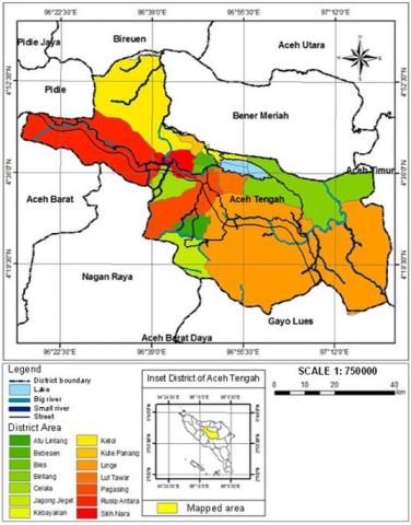
Research was carried out on an agricultural land potential index using a geographic information system in the Aceh Tengah regency, Aceh Province, Indonesia. The climate in this province is tropical with a characteristic location far from the seaside and tends to be in a hilly topography. This research was carried out from July 2018 to January 2019. The research location is presented in Figure 1. The method used in this research is a survey conducted through secondary data collection in relevant agencies. The data collected includes rainfall, administrative, slope, soil type, lithological, and land use maps. Raw data is then transformed into numerical data to be further converted into map data using GIS.
Figure 1. The location of Aceh Tengah regency as the object of the research area
2.2 Determination of land potential index
The hydrological map is generated by classifying climate types using the Schmidt-Ferguson method . This method compares the average percentage of dry months with the average of wet months. The dry month is if in one month the amount of rainfall is less than 60 mm, while the wet month is if in one month the amount of rainfall is greater than 100 mm.
Erosion susceptibility maps are generated by combining soil type maps, slope maps, land use maps, and rain erosivity maps, which overlay according to their weighting using a GIS application. Calculating the level of erosion risk in the study area uses the Universal Soil Loss Equation (USLE) approach using Eq. (1) .
A=R×K×L×S×C×P (1)
where, A-annual soil loss per acre, R-rainfall erosion, K-soil erodibility, L-slope length, S-slope steepness, C-vegetation cover, P-erosion control practices.
The potential land index is determined by assigning a score to each secondary data parameter of the relevant agencies. Each parameter is scored according to its effect on the land potential of the study area [17-19]. Then all parameter scores are added and erosion parameters are excluded. The results of the scoring calculation are then classified as potential land using Table 1. This study's land potential index class will at least represent the parameters of a land slope, soil type, lithology, land use, hydrology, erosion for protected forests, production forests, limited production forests, mixed gardens, plantations, settlements, wetland agriculture, dry land, agriculture, livestock, shrubs, and national parks.
Table 1. Land potential index class [20]
|
Land potential class |
Value |
|
Very high |
> 22.8 |
|
High |
18.5 – 22.7 |
|
Middle |
14.2 – 18.4 |
|
Low |
9.9 – 14.1 |
|
Very low |
< 9.8 |
3.1 Parameter of sloping land
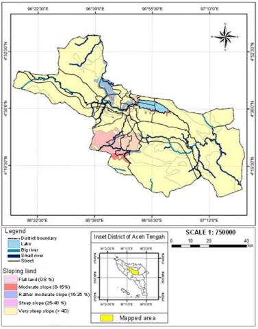
Figure 2. Characteristics of the land slope map in the regency of Aceh Tengah
The slope map of the regency of Aceh Tengah is presented in Figure 2. The total area of the slopes with flat conditions is 3.08% of the total area of the regency of Aceh Tengah. With moderate, relatively moderate, and moderate steep terrain, they are 1.18%, 1.91%, and 3.81% of the total area of the Regency of Aceh Tengah, respectively. The widest area is on very steep land slopes, with a total of 90.03% of the total area of the regency of Aceh Tengah.
Furthermore, the percentage of slope on the land based on its use consists of a cultivated area of 95,844.19 ha (21.56%) and a protected forest area of 348,688.44 ha (78.44%) of the total area of the Aceh Tengah regency. The land use according to the slope level refers to and follows the recommendations of the research results of Deshmukh et al. [21]. The cultivated area that does not require conservation measures is 6,086.55 ha (6.35%) of the total cultivated area with a slope of less than 8%. The cultivation areas that require conservation measures for the mound terraces are 3,590.54 ha (3.75%) of the total cultivable area with a slope range of 8% to 15%. The cultivar area that requires conservation measures for the soil of the bench terrace is 7,291.76 ha (7.61%) of the total cultivar area with a slope of 16% to 25%. The cultivation area requiring individual terrace soil conservation measures is 55,744.28 ha (58.16%) of the total cultivated area with a slope of 26% to 60%. The cultivated area that cannot be given soil conservation measures is 14,951.15 ha (15.60%) of the total cultivated area because it is located on a slope greater than 60%. According to the results of research by Liu et al. [22], the slope condition is difficult to cultivate as agricultural land. The rest are settlements and livestock, which have an area of 5,022.33 ha (5.24%) and 3,157.58 ha (3.29) of the total cultivated area.
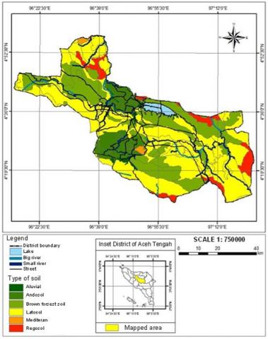
Figure 3. Characteristics of the soil type map in the regency of Aceh Tengah
3.2 Parameter of soil type
The soil types found at the research site are classified as brown forest soil, latosol, alluvial, regosol, andosol and mediterranean soil according to the 1974 UENESCO classification [23]. The map of soil types in the Aceh Tengah regency is presented in Figure 3. The latosol soil is the widest type of soil found in the Aceh Tengah regency, which is 230,166.76 ha (51.74%) of the total area. The types of andosols, regosol, and alluvial soil have 9.97%, 5.74%, and 2.56% of the total area, respectively. According to some literature [24-26] this type of soil is very suitable for agricultural cultivation, especially for horticultural crops and plantations. Mediterranean soil is the type of soil that has the smallest area of 3,052.58 ha (0.69%) of the total area.
3.3 Parameters of lithology
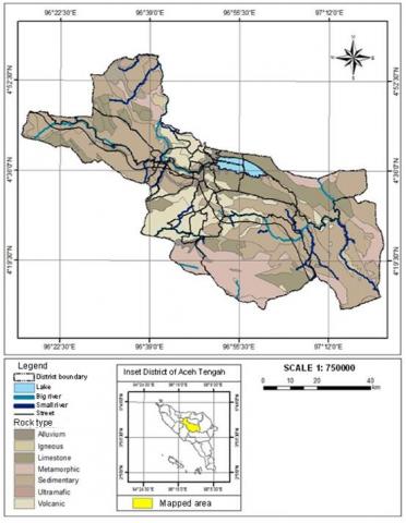
The rock types found in Aceh Tengah regency include alluvium rock, limestone rock, sedimentary rock, volcanic rock, igneous rock, metamorphic rock, and ultramafic rock. This type of rock is a classification commonly used as in previous studies [27-29]. The lithological distribution map in the Aceh Tengah regency is presented in Figure 4. The sedimentary rock types have the largest area of 211,242.53 ha (48.65%) of the total area. The types of limestone, metamorphic, volcanic, alluvium and igneous rock are 17.0%, 15.28%, 15.04%, 2.42% and 1.34%, respectively. Ultramafic rock types are rock types that have the smallest area with a wide difference between the two, which is 48.38%.
Figure 4. Characteristics of the lithology map in the regency of Aceh Tengah
3.4 Parameter of land use
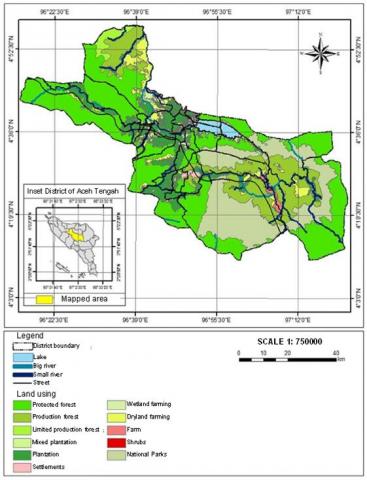
The land use of the Aceh Tengah regency is divided into 12 areas, including protected forests, production forests, limited production forests, mixed gardens, plantations, settlements, wetland agriculture, dry land agriculture, livestock, shrubs and national parks. The land use map in the Aceh Tengah regency is presented in Figure 5. According to Sartika et al. [30], this map must consider the needs of residential areas (75 m2/person) with other needs proportionally. The largest land use is protected forest, with 181,244.60 ha (40.67%) of the total area. The land use with the smallest area is a mixed garden with an area of 379.15 ha (0.09%).
3.5 Parameter of hydrology
The classification of climate types processed from rainfall data for the research area of the Aceh Tengah regency was carried out between 2009 and 2017 (Table 2). The average annual rainfall for nine years is 3,378.33 mm per year. The highest rainfall in 2017 was 4,129 mm and the smallest in 2016 was 2,790 mm. The regency of Aceh Tengah has 86 wet months and ten dry months according to the Schmidt-Ferguson classification [31-33]. The results of the analysis show that the average dry month is 1.1 months while the average wet month is 9.6. When comparing the average number of dry months and the average wet month, the percentage index value of Q is 12%. The Q-value index shows that Aceh Tengah regency is included in type A climate with a Q value ranging from 0 to 14.3%.
Figure 5. Characteristics of the land use in the regency of Aceh Tengah
Figure 6. Characteristics of Hazard Erosion in the Regency of Aceh Tengah
Table 2. Rainfall data in the Regency of Aceh Tengah
|
Months |
2009 |
2010 |
2011 |
2012 |
2013 |
2014 |
2015 |
2016 |
2017 |
|
January |
93 |
451 |
292 |
179 |
201 |
58 |
174 |
180 |
679 |
|
February |
236 |
217 |
256 |
274 |
128 |
57 |
89 |
202 |
259 |
|
March |
310 |
426 |
483 |
335 |
155 |
94 |
167 |
158 |
386 |
|
April |
128 |
695 |
254 |
498 |
219 |
427 |
401 |
251 |
635 |
|
May |
80 |
261 |
302 |
65 |
627 |
424 |
625 |
191 |
280 |
|
June |
79 |
180 |
39 |
105 |
172 |
17 |
86 |
278 |
195 |
|
July |
77 |
117 |
24 |
157 |
39 |
21 |
106 |
82 |
52 |
|
August |
184 |
52 |
459 |
404 |
157 |
52 |
244 |
234 |
222 |
|
September |
275 |
272 |
219 |
244 |
92 |
459 |
360 |
198 |
483 |
|
October |
768 |
244 |
96 |
286 |
330 |
600 |
1002 |
170 |
82 |
|
November |
651 |
366 |
294 |
849 |
275 |
296 |
372 |
486 |
433 |
|
December |
624 |
341 |
249 |
320 |
536 |
445 |
169 |
360 |
423 |
3.6 Parameter of erosion
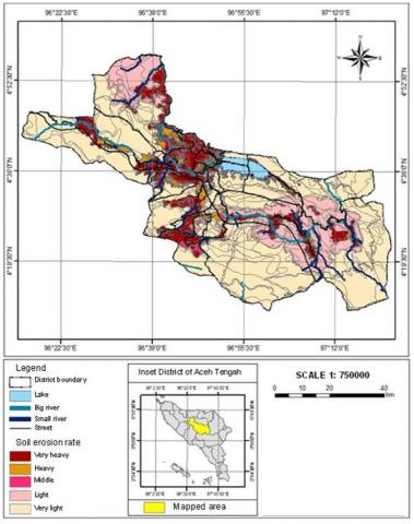
The erosion hazard in this study was obtained from calculations using the USLE method . The erosion hazard distribution map in the Central Aceh Regency is presented in Figure 6. The annual rainfall erosivity is obtained from the average rainfall from January to December 2017, 271.80 cm per year. The risk of erosion in the use of protected forest land is the largest, 180,047.15 ha (41.17%), in the category of mild risk of erosion. Meanwhile, livestock is a land that has the smallest erosion risk area, which is 0.17 ha, with a moderate erosion risk category in conformity with the expression listed by . Land use in settlements has a high erosion value of 155,947.22 tons per ha per year. Meanwhile, land use in limited production forests has the lowest erosion value of 92.51 tons per ha per year. The area with the largest area experiencing erosion hazards is 268,621.27 ha, a very light category. In contrast, the area with the smallest area is 3,300.76 ha in the medium category.
3.7 Land potential index
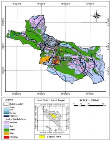
The results of the map of the land potential index of the Aceh Tengah regency on a scale of 1: 750,000 are presented in Figure 7. The land potential index map is developed by overlaying intersections of five parameters, including slope maps, lithology maps, soil type maps, hydrological maps and erosion hazard maps. The development of the overlay of the five parameters takes the form of a map unit that stores information on the index value of the land potential of the Aceh Tengah regency. The overlay results will provide a land potential index value for each region in the Central Aceh Regency area, which is then classified into land potential index classes. The potential of the land can be classified from very low to very high, with each value being less than 9.8 (very low), 9.9 – 14.1 (low), 14.2 – 18.4 (moderate), 18.5 – 22.7 (high) and greater than 22.8 (very high).
The distribution of very high land potential index areas is only found in a few districts in the regency of Aceh Tengah. The highest level of land potential index is found in the Linge district. Furthermore, they are in Atu Lintang District and so on in Lut Tawar District, Pegasing District, Bintang District, Jagong Jeget District, Kebayakan District, Ketol District and Celala District. Districts that do not have a very high level of land potential index include Kute Panang, Rusip Antara, Bies, Silih Nara, and Bebesen. The study results found that the level of land potential with the highest area was the medium land potential index with an area of 164,788.56 ha (37.76%) and the very low land potential index was 102,022.42 ha (23.38%). Areas with a low land potential index have an area of 148,425.89 ha (34.01%). The high potential land index only has 3.98% of the total land area. The remaining 0.87% of the Aceh Tengah regency area is an area with a very high land potential index.
Figure 7. Map of land potential index in the regency of Aceh Tengah
The Geographic Information System can identify and be used to analyze the Land Potential Index in the Aceh Tengah regency using an overlay of five parameters, namely slope, lithology, soil type, hydrology, and erosion. There are five classes of the land potential index in the regency of Aceh Tengah, one of which is very low and very high. The very low category has the largest area of 102.002.42 ha (23.38%) with a slope greater than 40%, soil types and rock types latosol and sedimentary and erosion susceptibility with very heavy and moderate conditions. Although the very high category has the smallest area of 3,807.80 ha (0.87%) with a slope of 0 – 15%, the types of soil are brown forest soil, mediterranean soil, and andosol, the types of rock are alluvium and volcanic, and the susceptibility to erosion is included in the very light class. The land potential index with very high criteria in the Aceh Tengah regency is located in the Linge district, Atu Lintang district, Lut Tawar district, Pegasing district, Bintang district, Jagong Jeget district, Kebayakan district, Ketol district and Celala district with an area of 2,014.26 ha, 1,266.33 ha, 174.81 ha, 148.07 ha, 77.86 ha, 73.63 ha, 46.77 ha, 4.14 ha and 1.94 ha, respectively. Meanwhile, the land potential index with very low criteria was found in all districts except the Kute Panang and Atu Lintang districts.
[1] Bahri, T.S., Romano, D. (2014). Potensi dan skenario perkembangan tiga pangan pokok berbasis kluster di provinsi aceh. Jurnal Ekonomi dan Pembangunan, 5(1): 1-10.
[2] Vasu, D., Srivastava, R., Patil, N.G., Tiwary, P., Chandran, P., Singh, S.K. (2018). A comparative assessment of land suitability evaluation methods for agricultural land use planning at village level. Land Use Policy, 79: 146-163. https://doi.org/10.1016/j.landusepol.2018.08.007
[3] Marraccini, E., Gotor, A.A., Scheurer, O., Leclercq, C. (2020). An innovative land suitability method to assess the potential for the introduction of a new crop at a regional level. Agronomy, 10(3): 330. https://doi.org/10.3390/agronomy10030330
[4] Reshmidevi, T., Eldho, T., Jana, R. (2009). A GIS-integrated fuzzy rule-based inference system for land suitability evaluation in agricultural watersheds. Agricultural Systems, 101(1-2): 101-109. http://dx.doi.org/10.1016/j.agsy.2009.04.001
[5] Cebro, I.S., Sitorus, A. (2019). Performance evaluation of a hand tractor to climbing sloping land. International Journal of Scientific and Technology Research, 8(7): 781-785.
[6] AbdelRahman, M.A., Natarajan, A., Hegde, R. (2016). Assessment of land suitability and capability by integrating remote sensing and GIS for agriculture in Chamarajanagar district, Karnataka, India. The Egyptian Journal of Remote Sensing and Space Science, 19(1): 125-141. https://doi.org/10.1016/j.ejrs.2016.02.001
[7] Habibie, M.I., Noguchi, R., Shusuke, M., Ahamed, T. (2021). Land suitability analysis for maize production in Indonesia using satellite remote sensing and GIS-based multicriteria decision support system. GeoJournal, 86(2): 777-807. https://doi.org/10.1007/s10708-019-10091-5
[8] Fahruddin, D., Purwati, E., Thamren, D.S., Sitorus, A. (2021). Application of geographic information systems and sediment routing methods in sediment mapping in Krueng Jreu Sub-Watershed, Aceh Province, Indonesia. International Journal of Sustainable Development and Planning, 16(7): 1253-1261. https://doi.org/10.18280/ijsdp.160706
[9] Wang, D.C., Li, C.J., Song, X.Y., Wang, J.H., Yang, X.D., Huang, W.J., Wang, J.Y., Zhou, J.H. (2011). Assessment of land suitability potentials for selecting winter wheat cultivation areas in Beijing, China, using RS and GIS. Agricultural Sciences in China, 10(9): 1419-1430. http://dx.doi.org/10.1016/S1671-2927(11)60135-1
[10] Yalew, S.G., Van Griensven, A., Mul, M.L., van der Zaag, P. (2016). Land suitability analysis for agriculture in the Abbay basin using remote sensing, GIS and AHP techniques. Modeling Earth Systems and Environment, 2(2): 1-14. https://doi.org/10.1007/s40808-016-0167-x
[11] Sudarman, I., Ahmad, A. (2021). Mapping of landslide-prone areas in the Lisu river basin Barru Regency based on binary logistic regression. In IOP Conference Series: Earth and Environmental Science, 807(2): 022081. http://dx.doi.org/10.1088/1755-1315/807/2/022081
[12] Hartomo, K.D., Sri Yulianto, J.P., Gumilanggeng, E. (2018). Spatial model of koppen climate classification using thiessen polygon optimization algorithm. Journal of Theoretical & Applied Information Technology, 96(2): 382-391.
[13] Anitasari, I., Setyawan, B., Soesilo, A.W. (2020). Potential and stability of promising fine flavor cocoa clones in different seasons. Pelita Perkebunan (a Coffee and Cocoa Research Journal), 36(2): 109-119.
[14] Pham, T.G., Degener, J., Kappas, M. (2018). Integrated universal soil loss equation (USLE) and Geographical Information System (GIS) for soil erosion estimation in a sap basin: Central Vietnam. International Soil and Water Conservation Research, 6(2): 99-110. http://dx.doi.org/10.1016/j.iswcr.2018.01.001
[15] Hung, A.P., Phan, B.H., Nguyen, Q.V., Le Xuan, T., Le Sy, C., Nguyen, X.H. (2019). Integrated geographical information system (GIS) and remote sensing for soil erosion assessment by using universal soil loss equation (USLE): Case study in Son La Province. VNU Journal of Science: Earth and Environmental Sciences, 35(1). https://doi.org/10.25073/2588-1094/vnuees.4350
[16] Bekele, B. Gemi, Y. (2021). Soil erosion risk and sediment yield assessment with universal soil loss equation and GIS: In Dijo watershed, Rift valley Basin of Ethiopia. Modeling Earth Systems and Environment, 7(1): 273-291. https://doi.org/10.1007/s40808-020-01017-z
[17] Bandyopadhyay, S., Jaiswal, R., Hegde, V., Jayaraman, V. (2009). Assessment of land suitability potentials for agriculture using a remote sensing and GIS based approach. International Journal of Remote Sensing, 30(4): 879-895. https://doi.org/10.1080/01431160802395235
[18] Mohammed, S., Alsafadi, K., Ali, H., Mousavi, S.M.N., Kiwan, S., Hennawi, S., Harsanyie, E., Pham, Q.B., Linh, N.T.T., Ali, R. (2022). Assessment of land suitability potentials for winter wheat cultivation by using a multi criteria decision Support-Geographic information system (MCDS-GIS) approach in Al-Yarmouk Basin (S syria). Geocarto International, 37(6): 1645-1663. https://doi.org/10.1080/10106049.2020.1790674
[19] Layomi Jayasinghe, S., Kumar, L., Sandamali, J. (2019). Assessment of potential land suitability for tea (Camellia sinensis (L.) O. Kuntze) in Sri Lanka using a GIS-based multi-criteria approach. Agriculture, 9(7): 148. https://doi.org/10.3390/agriculture9070148
[20] Marco, R., Vitianingsih, A.V., Maukar, A.L., Puspitarini, E.W., Wati, S.F.A. (2021). Geographical information system for mapping of settlements land potential index. In 2021 4th International Conference on Information and Communications Technology (ICOIACT), pp. 137-142. https://doi.org/10.1109/ICOIACT53268.2021.9564009
[21] Deshmukh, D.S., Chaube, U.C., Ekube Hailu, A., Aberra Gudeta, D., Tegene Kassa, M. (2013). Estimation and comparision of curve numbers based on dynamic land use land cover change, observed rainfall-runoff data and land slope. Journal of Hydrology, 492: 89-101. https://doi.org/10.1016/j.jhydrol.2013.04.001
[22] Liu, B.Y., Nearing, M.A., Shi, P.J., Jia, Z.W. (2000). Slope length effects on soil loss for steep slopes. Soil Science Society of America Journal, 64(5): 1759-1763. https://doi.org/10.2136/sssaj2000.6451759x
[23] Matthews, E. (1983). Global vegetation and land use: New high-resolution data bases for climate studies. Journal of Applied Meteorology and Climatology, 22(3): 474-487. https://doi.org/10.1175/1520-0450%281983%29022%3C0474%3AGVALUN%3E2.0.CO%3B2
[24] Yu, H., Zhang, Z., Zhang, Y., Song, Q.D, Fan, P., Xi, B.D., Tan, W.B. (2021). Effects of micro.plastics on soil organic carbon and greenhouse gas emissions in the context of straw incorporation: A comparison with different types of soil. Environmental Pollution, 288: 117733. https://doi.org/10.1016/j.envpol.2021.117733
[25] Ling, D.J., Huang, Q.C., Ouyang, Y. (2010). Impacts of simulated acid rain on soil enzyme activities in a latosol. Ecotoxicology and Environmental Safety, 73(8): 1914-1918. https://doi.org/10.1016/j.ecoenv.2010.07.024
[26] Fahmi, A., Utami, S.N.H., Radjagukguk, B. (2010). Pengaruh interaksi hara nitrogen dan fosfor terhadap pertumbuhan tanaman jagung (Zea mays L) pada tanah regosol dan latosol. Berita Biologi, 10(3): 297-304. https://doi.org/10.14203/BERITABIOLOGI.V10I3.744
[27] Wakita, K. (2013). Geology and tectonics of Japanese islands: A review–the key to understanding the geology of Asia. Journal of Asian Earth Sciences, 72: 75-87. https://doi.org/10.1016/j.jseaes.2012.04.014
[28] Dimalanta, C.B., Ramos, E.G.L., Yumul Jr, G.P., Bellon, H. (2009). New features from the Romblon Island Group: Key to understanding the arc–continent collision in Central Philippines. Tectonophysics, 479(1-2): 120-129. https://doi.org/10.1016/j.tecto.2009.02.015
[29] Flint, D.E., de Albear, J.F., Guild, P.W. (1984). Geology and chromite deposits of the Camagüey district, Camagüey Province, Cuba. USGS Numbered Series. https://doi.org/10.3133/b954B
[30] Sartika, T.D., Pandjaitan, N.H., Sitorus, A. (2017). Measurement and modelling the drainage coefficient for hydraulic design criteria on residential area. In 3rd International Conference on Computing, Engineering, and Design, ICCED, pp. 1-5. https://doi.org/10.1109/CED.2017.8308092
[31] Winarno, Mustari, K., Yassi, A. (2021). Strategy for adaptation of rice plant management on the climate changes impacts in Soppeng Regency, South Sulawesi Province, Indonesia. In IOP Conference Series: Earth and Environmental Science, 807: 042047. https://doi.org/10.1088/1755-1315/807/4/042047
[32] Herawati, T., Yustiati, A., Iskandar., Zahidah., Juahir, H. (2019). Characteristics of weather and rainfall projection in 2021 around Jatigede Dam West Java for fisheries management. International Journal of Innovation, Creativity and Change, 9(12): 125-147.
[33] Wibowo, S.B. (2020). Use of the Oldeman and Schmidt-Ferguson classifications for the aptitude of soils to be cultivated at Batu, Indonesia. In IAHS-AISH Publication, 181-182.
[34] Safar, M., Ishak, M.G., Tunas, I.G. (2022). Analysis of erosion and sediment movement at the confluence of two rivers (A case study of Tawaeli River, Central Sulawesi, Indonesia). International Journal of Design and Nature and Ecodynamics, 17(1): 55-62. https://doi.org/10.18280/ijdne.170107
[35] Azmeri, A., Nurbaiti, N., Mawaddah, N., Yunita, H., Jemi, F.Z., Sundary, D. (2022). Surface erosion hazard and sediment yield for Keuliling Reservoir in Indonesia. Journal of Water and Land Development, 52(I-III): 108-118. https://doi.org/10.24425/jwld.2022.140380
[36] Rofikha, A.A., Saputra, Y., Islami, F.A. (2021). Best management practices for erosion and sedimentation control of the Sermo Watershed. In IOP Conference Series: Earth and Environmental Science, 930: 012068. https://doi.org/10.1088/1755-1315/930/1/012068
[37] Chen, S.F., Liu, W., Bai, Y.H., Luo, X.Y., Li, H.F., Zha, X. (2021). Evaluation of watershed soil erosion hazard using combination weight and GIS: A case study from eroded soil in Southern China. Natural Hazards, 109(2): 1603-1628. https://doi.org/10.1007/s11069-021-04891-7