Wesam S. Mohammed-Ali*![]() | Mohammed F. Yass
| Mohammed F. Yass![]() | Rasul M. Khalaf
| Rasul M. Khalaf![]()
© 2025 The authors. This article is published by IIETA and is licensed under the CC BY 4.0 license (http://creativecommons.org/licenses/by/4.0/).
OPEN ACCESS
Riverbank erosion is one of the important issues and challenges faced and studied by river management experts. It is one of the main risks that threatens people and structures, as it causes the loss of nearby land from the river. Erosion happens because of hydraulic forces from river water acting on the riverbank or due to the weakening and wearing away of the soil layers that make up the riverbank. A field study of riverbank erosion was carried out over five years at Baiji city along the Tigris River in Salah Al-Din governorate on the right riverbank of the river. Field measurements were conducted from 2020 to the end of 2024, with two measurements and observations carried out each year at different periods to ensure coverage of all the different water levels of the river. This allowed for long-term monitoring of the riverbank to observe the changes occurring during the study period. The discharges during the study period ranged between 420 m³/sec to 2120 m³/sec. The results showed that the amount of erosion on the riverbank was 62 cm, which can be considered slightly high given the current conditions in the region, and it should be taken into account that the rate may increase if favorable conditions arise for the erosion process.
erosion process, river management, Tigris River, river mechanics, long-term monitoring
River systems are among the most significant natural systems in the world, and their management must be approached with caution due to their direct impact on humans and nearby hydraulic structures. Erosion, which occurs due to stream power, whether occurring in the riverbed or along its riverbanks, represents a major issue that threatens river systems. Erosion has the potential to change the course of the river, its morphology, the shape and extent of the floodplain, as well as the configuration of its riverbanks [1]. Moreover, erosion negatively affects water quality by increasing turbidity levels, which can degrade the overall water characteristics. This erosion occurring in river systems leads to an increase in sediment, particularly riverbank erosion, which may account for more than 85% of the total sediment load [2]. High concentrations of sediments negatively impact water quality and harm aquatic ecosystems, particularly fish populations, reduce the amount of dissolved oxygen in the water, limit light penetration to aquatic plants, and change the water temperature [3]. An increase in the concentration of suspended sediments in rivers adversely affects the respiration process of fish by causing blockage of their gills. This reduces their uptake of dissolved oxygen in the water, which ultimately leads to fish mortality in many cases [4]. Sediment is considered the second leading cause of river water pollution after bacteria and is estimated to impact approximately 31% of river miles [5].
As a result of the excessive shear forces exerted by the flowing water on the riverbed and riverbanks, the erosion process begins, followed by the transportation of soil particles resulting from erosion to other locations, a phenomenon known as hydraulic action. The higher the water velocity, the greater the frictional forces between the water and the sediments, leading to increased shear forces. This phenomenon is caused by several factors, including the high elevation of the riverbank or its steep slope (riverbank geometry) [6]. The type and cohesion of the soil layers [7], or a drawdown in river water levels [8], which leaves the riverbank saturated and heavily loaded without lateral support from the river, can influence the erosion process [9]. As a result, mass failure can result from erosion at the toe of the riverbank, which destabilizes the overlying soil layers, leading to their collapse [10]. To mitigate the negative impacts of erosion and enhance water quality, it has become essential to conduct field studies on riverbanks to estimate erosion rates that may occur in the future. This will enable the estimation of the total sediment load in the river and provide insights into how to manage it effectively [11]. Riparian habitats are critical areas within aquatic systems, serving as transitional zones between land and water. These habitats provide living spaces for many aquatic species and act as natural filters by trapping sediments and purifying pollutants in the water. Therefore, it has become essential to preserve these areas and prevent erosion, which could lead to their destruction and degradation. The issue of erosion results in the loss of significant portions of land adjacent to rivers, which increases concerns among landowners [12].
On the other hand, riverbank erosion occurs when the hydraulic forces exerted by the flowing water increase and exceed the strength of the soil that forms the riverbank. The rate of this type of erosion can be predicted by understanding the distribution of boundary shear stress [13]. Additionally, the high costs associated with implementing measures to reduce or prevent erosion further exacerbate the problem. Therefore, it has become essential to restrict human activities and infrastructures that may be subjected to harm or intensify erosion [14].
Erosion rates are influenced by several factors, including the characteristics of river water, which is a key factor. This includes the discharge rate, flow velocity, turbulence of the water, presence of surface waves, and fluctuations in water levels due to changes in discharge. These factors affect the height of the water in the river and its interaction with the riverbank. Another important factor is the shear stress exerted by the flowing water on the riverbank, as higher shear stress significantly increases erosion rates. Other factors are equally important, such as the type, stratification, and homogeneity of the soil that makes up the riverbank, as well as the soil moisture and pore pressure between soil particles. Climate also plays a role, especially with repeated heavy rainfall and freeze-thaw cycles [4]. Biological factors, such as the presence of vegetation, the density of plant cover, and animal activity on the bank, also influence erosion. Human activities, including agriculture, navigation, construction of hydraulic structures, and recreational activities, are external factors that contribute to erosion [15].
Additionally, the geometry of the riverbank has a major and clear effect on erosion. Factors like the height and slope of the riverbank, as well as the degree of river curvature in a specific area, significantly impact erosion processes [7]. Over time, rivers naturally alter their shape, characteristics, and riverbanks. Understanding these changes and how to manage them is critical for estimating riverbank erosion. This can be achieved by deriving approximate mathematical relationships that link flow patterns, water velocity, and riverbank properties. It is also essential to distinguish between rivers with bedrock channels, which have reached a state of armoring where no further bed erosion occurs (with sediments and erosion limited to the riverbanks), and rivers with alluvial beds, where erosion can occur in both the channel bed and the riverbanks [16]. Distinguishing between these two types is essential and fundamental for understanding the mechanisms of erosion. Bedrock rivers are characterized by a substrate composed of large rocks or coarse gravel, as finer sediments and small-sized particles are typically removed over time by the flowing water. In this type of river, erosion processes are minimal or nearly absent, and erosion typically occurs only along the riverbanks due to intense hydraulic forces. Meanwhile, the riverbed remains stable, as it has reached an armoring stage. The second type of river, characterized by an alluvial bed composed of sand, silt, and gravel, is more susceptible to erosion processes. The shape of the riverbed changes over time due to ongoing erosion and sediment deposition. This distinction between the two types of riverbeds is highly essential in field studies to determine the appropriate methods for measuring the erosion and sedimentation processes occurring in the river [7].
The river course typically changes due to processes acting upon it, namely erosion and deposition. Erosion occurs as a result of the hydraulic action exerted by the river on its riverbanks or due to mass failure occurring within the soil layers [17].
There are numerous international studies that address the issue of riverbank erosion due to its significance for those concerned with river management. However, studies related to erosion or riverbank stability along the Tigris River are limited and very scarce. Therefore, this study was conducted on the Tigris River, which is subject to seasonal floods that influence the erosion process, in addition to fluctuating discharges and human activities along its riverbanks, particularly in the study area (Baiji). The main objective of this study is to estimate and calculate the erosion rate occurring on the riverbank of the Tigris River within the study area through field measurements. This is essential for predicting the risks that hydraulic structures located near the river may be exposed to. It is also crucial for reducing the problems caused by erosion processes on citizens' lands, thereby making the area safer for both the people and their lands. Moreover, the lack of long-term field monitoring data in Iraq may limit the ability to accurately assess erosion rates and predict future risks. These gaps highlight the necessity of this research, which aims to develop and apply a long-term, field-based technique using ADCP measurements to quantify erosion in a high-risk zone. Finally, studying riverbank erosion and estimating its rates is of great importance in identifying vulnerable and weak areas. These areas can then be targeted with various protective measures to maintain ecological balance and preserve biodiversity along the riverbanks.
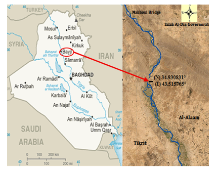
Baiji is a city located in Salah Al-Din Governorate in northern Iraq. It is an important area both geographically and economically for the governorate and the country. The Tigris River, one of the main rivers in Iraq, flows through the city, giving it extra importance. The river has encouraged residents to focus on farming, increase production, and make use of fishing resources, which help boost the city's economy. It covers an area of 14.60 square kilometers and has a population of 173000 [18]. The study area is influenced by seasonal hydrological cycles due to increased discharges of the Tigris River in the spring season, during which the flow rates reach their maximum levels which ranging between 1500 and 2120 m³/s in the years 2020 and 2021 during the study period. Conversely, the river discharge decreases over extended periods of the year, reaching a minimum value of 420 m³/s. These seasonal variations, along with discharge instability and fluctuations in water velocity, lead to erosion along the riverbank. The repeated cycles of saturation and drying weaken the soil structure, making the riverbanks more susceptible to cracking and erosion.
Additionally, climatic changes and human activities contribute directly or indirectly to increasing erosion rates. The aerial image in Figure 1 shows the location of the riverbank where the erosion measurements were taken, situated in a contraction area within the Tigris River. This contraction zone of the Tigris River, where the channel width narrows, leads to an increase in flow velocity and hydraulic shear stress, thereby raising the likelihood of erosion processes occurring in these regions. When contraction zones are compared to wider sections of the river, they are found to be more susceptible to morphological changes due to the increased flow velocity and the river's enhanced capacity to transport sediments. Therefore, the location of the study area within a contraction zone is one of the contributing factors to the occurrence of erosion processes observed during the study period.
Figure 1. The location of the riverbank erosion study was conducted
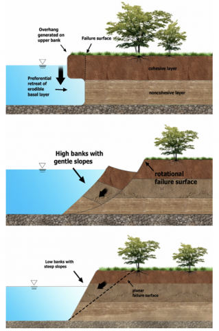
Erosion occurs as a result of both hydraulic action and mass failure acting together. This process begins with erosion at the toe of the riverbank caused by hydraulic action, leading to changes in the slope and height of the riverbank [19]. These changes cause gravitational forces to exceed the cohesive and adhesive forces between the soil particles of the riverbank. When water levels rise, the increase in water velocity and shear stress further erodes the lower portion of the riverbank (the toe). As water levels drop, the riverbank becomes overhanging and unsupported from below, ultimately resulting in mass failure.
Figure 2. The mechanism of the failure due to erosion [11]
This high-water velocity enhances the water's capacity to mobilize sediments and erode the soil. The water then transports the eroded particles downstream until they reach areas where the water velocity decreases, allowing the particles to settle. It is well known that water velocity decreases as it approaches the riverbed mass failure of the riverbank occurs when a large section of the riverbank soil separates at once and collapses into the river, as shown in Figure 2.
There are two types of erosion: the first occurs at the riverbed, and the second occurs at the riverbank. Bed erosion happens when there is an imbalance in the forces acting on the riverbed, especially if the bed material consists of silt or sand. Many previous studies have extensively investigated the magnitude of hydraulic shear stress exerted on the riverbed. However, in the wide channel, the shear stress on the bed can be calculated using the following equation:
$\tau=\gamma R S$ (1)
where $\tau$ represents the mean boundary shear stress, $\gamma$ represents the specific weight of water, R represents the hydraulic radius of the channel, and S represents the slope of the channel.
Consequently, on the channel sides, the shear stress varies as it depends on the slope rather than the width. Therefore, when studying riverbank erosion, calculating boundary shear stress alone is not suitable for estimating riverbank erosion, as the distribution of shear stress is not uniform along the channel's cross-section [20]. In fact, the water velocity varies with depth. The velocity is highest at the center of the flow, where the shear stress is zero, while the velocity near the riverbed is the lowest, approaching zero, and the shear stress is at its maximum due to friction. The distribution of velocities in rivers can be observed as shown in Figure 3.
Figure 3. Distribution of water velocities in natural rivers [7]
Riverbank erosion depends on the balance between hydraulic and geotechnical forces and the erodibility of the soil particles that make up the riverbank. The cohesion between soil particles varies depending on the type of soil. For example, clay soils exhibit higher cohesion compared to sandy or gravelly soils, making it more difficult to predict the erosion rates of such cohesive soils. Even in cases where fine-grained particles are mixed with sandy or gravelly soils, they can significantly influence and alter the erosion behavior of the soil. This is because the main factors affecting the critical shear stress will change [21].
Other factors make predicting the rate of erosion more complex and challenging, depending on the properties of the soil material composing the riverbank. These factors include the degree of soil saturation with water, its density, porosity, stratification, and the presence of minerals mixed with the soil particles, in addition to the specific geometry of the riverbank. For example, in cohesive soils, the bulk density of the soil becomes significantly important compared to the particle size of the soil composing the riverbank, which plays a secondary role in the erosion process [21]. These cohesive soil materials can become either more resistant or less resistant to erosion depending on the flooding events they are exposed to, as well as the amount of rainfall and the freeze-thaw cycles. Therefore, due to these ever-changing environmental conditions that affect the resistance of soil to erosion, many researchers collect natural soil samples (composing the riverbank) and transfer them to the laboratory to directly measure the critical shear stress. However, this method may alter the structure and properties of the soil, potentially resulting in less accurate predictions of the future erosion processes that may occur on the riverbank [22].
The susceptibility of riverbanks to erosion is also influenced by the presence of roughness features on the riverbed (such as ripples and dunes) and along the banks (such as slump blocks). These features affect how shear stress is distributed, which in turn impacts the detachment of soil particles. The total shear stress acting on the riverbed and riverbanks consists of two main components: skin friction and form drag. When studying erosion processes, it is essential to distinguish between these two components to fully understand the mechanisms of erosion. Skin friction acts directly on the surface of soil particles and represents the portion of shear stress that directly affects of these particles. It causes the detachment and subsequent movement of particles, and therefore, it can be considered the primary driver of the erosion process and sediment transport. The form drag results from flow turbulence and acting on roughness elements like vegetation or bedforms. While form drag contributes to overall flow resistance, it does not directly initiate erosion. In this context, only the skin friction component contributes directly to the erosion process, whereas form drag reduces the effective shear stress available for particle detachment. Distinguishing between these two components is therefore critical for accurately assessing soil erodibility and developing effective riverbank protection strategies [23]. As a result, when roughness elements absorb more shear stress, less stress is available to act on soil particles, reducing the energy available for erosion. Additionally, minor topographic variations along the bank, often resulting from slumping, can introduce form drag, leading to significant changes in flow dynamics within the river channel [24].
Large-scale mass-wasting events may create a stabilizing feedback mechanism, as the slump blocks act as roughness elements that dissipate a significant portion of the flow's shear stress, thereby enhancing the overall stability of the riverbank. Erosion rates are influenced by the presence and density of vegetation on the riverbank. Vegetation enhances soil cohesion, thereby increasing its resistance to erosion by reducing the amount of shear stress exerted on the soil. This effect of vegetation can also be observed on riverbanks with sparse vegetation cover, where surface shear stress is also reduced [25].
Therefore, when studying riverbank erosion in natural environments, it is essential to consider the impact of vegetation on the riverbank, as it can significantly alter erosion rates [26]. Riverbanks contain multiple layers, or what is referred to as geological stratigraphy, and are more exposed to erosion due to the sliding of layers over one another caused by subsurface water flow and groundwater seepage [27].
Additionally, the physical properties of these layers and their variation from one layer to another further increase the probability of erosion. The erosion does not occur only on riverbanks; riverbeds are also subject to erosion but to a lesser extent. This is because riverbeds remain continuously submerged and are not exposed to atmospheric variations. This explains why erosion is more pronounced on riverbanks compared to riverbeds [28].
There are various methods used to measure the extent of erosion occurring on riverbanks. For instance, one method relies on aerial imagery captured by satellites. Many researchers have studied and measured riverbank erosion using these images [29, 30]. By comparing satellite images taken at two different periods, it is possible to identify and quantify the erosion that has occurred along the riverbanks. Another method to measure and determine the extent of riverbank erosion is by using metal pins installed locally at different heights along the riverbank. The amount of erosion can be estimated by comparing the length of these pins exposed or buried over two different periods [31]. Another method relies on topographic surveying, which is widely used and yields accurate results. By determining and measuring the riverbank profile and comparing its elevation to a fixed reference point over two different periods, the extent of riverbank erosion can be calculated.
Additionally, this method allows for identifying the riverbed morphology and assessing the ongoing processes, whether they involve erosion or deposition [32]. Another method involves determining the amount of erosion theoretically, as the rate of erosion is linearly related to the near-bank water velocity. By calculating the difference between the depth-averaged water velocity and the mean cross-sectional velocity of the river, it is possible to predict the extent of erosion occurring on the riverbank [33]. Another approach to determining the extent of erosion is by measuring the boundary shear stress along the river rather than relying solely on velocity variation. This method is considered one of the primary techniques used to predict and quantify the erosion of fine-grained soil particles. It employs the following equation to calculate the excess shear stress [34]:
$\varepsilon=k d\left(\tau_a-\tau_c\right)$ (2)
where ε is the erosion rate (m/sec), kd is the erodibility coefficient (m3/N.S), a is an exponent (usually assumed to be 1), $\tau_{\mathrm{a}}$ is the applied shear stress (N/m2), and $\tau_{\mathrm{c}}$ is the critical shear stress (N/m2).
Furthermore, there is a method for measuring erosion in laboratory flumes, which are designed and prepared using natural soil from the riverbank being studied. While this method is useful for representing the erosion processes occurring on riverbanks, as it allows for the control of various variables such as bank geometry, flow characteristics, and the material properties of the soil composing the bank, it also has several limitations that must be carefully considered when applying its results to natural rivers [35]. Natural rivers lack the regular and simple geometry found in laboratory setups, and the flow in natural channels is rarely uniform, unlike the controlled conditions in the lab [36]. Additionally, the properties of the soil, including its cohesion and structural integrity, may significantly change when it is transported from the natural environment to the laboratory [37].
The modern methodology utilized herein in this study relies on measuring the change in riverbank cross-section as a long-term variation. This method to measure the erosion process is called long-term riverbank erosion monitoring and is used in this study to assessment the relative impact of riverbank erosion along the Tigris River. The long-term riverbank erosion was monitored from 2020 to the end of 2024 using standard surveying methods.
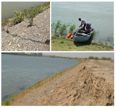
To measure the extent of riverbank erosion along the Tigris River in the city of Baiji, Salah Al-Din Governorate, the specific riverbank section selected for measurement was marked with fixed reference points. These markers were established to ensure that measurements and observations could be conducted at the same locations with regular maintenance and periodic care, as shown in Figure 4. It allows for an accurate assessment of erosion over the research period; also, the selected cross-section for studying erosion is located near the Baiji discharge gauge.
Figure 4. The measurement process for cross-section
The cross-section of the river was selected to study the erosion that occurred in it due to the importance of the area and the presence of many hydraulic structures, such as water treatment plants and discharge gauges, as well as consists of agricultural lands. The dimensions and profiles obtained were compared using data recorded by the Acoustic Doppler Water Measurement Device. An M9 Acoustic Doppler Current Profiler (ADCP) was used to measure the geometry of these cross-sections. The ADCP is a hydroacoustic device used in oceanography, hydrology, and environmental monitoring. It is designed to measure water current velocities at various depths also used to plot the river cross-section between the two riverbanks. The geometry of the cross-section at the beginning and end of the frame time was established to address the variation in cross-section boundary.
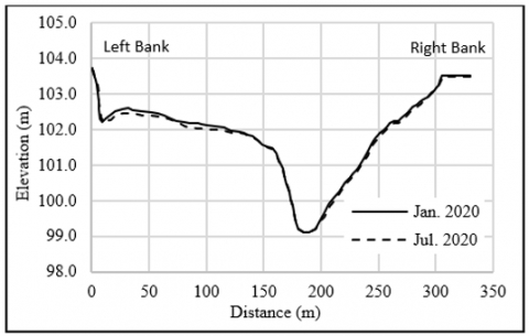
First of all, Figure 5 represents the geometry of the cross-section for the firm time between January 2020 and July 2020.
It is clear from the collected data shown in Figure 5 that there is a change in the river bed elevation at a certain point along the cross-section, which indicates that some of the materials were washed or eroded from this cross-section.
For the same purpose, the following Figures 6-13 illustrate the variation in the local station during different periods.
Figure 5. The geometry of the selected station in Jan. 2020 and Jul. 2020
Figure 6. The geometry of the selected station in Jul. 2020 and Mar. 2021
Figure 7. The geometry of the selected station in Mar. 2021 and Aug. 2021
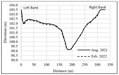
Figure 8. The geometry of the selected station in Aug. 2021 and Feb. 2022
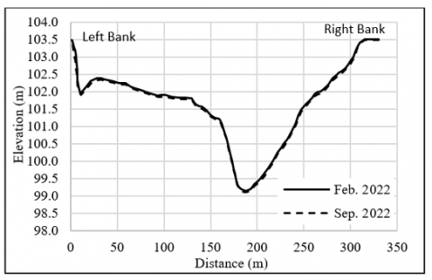
Figure 9. The geometry of the selected station in Feb. 2022 and Sep. 2022
Figure 10. The geometry of the selected station in Sep. 2022 and Jan. 2023
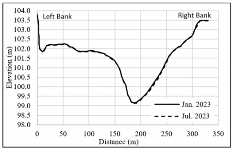
Figure 11. The geometry of the selected station in Jan. 2023 and Jul. 2023
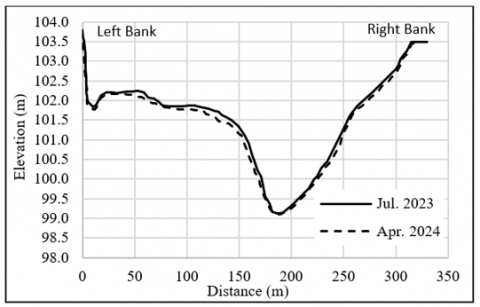
Figure 12. The geometry of the selected station in Jul. 2023 and Apr. 2024
Figure 13. The geometry of the selected station in Apr. 2024 and Nov. 2024
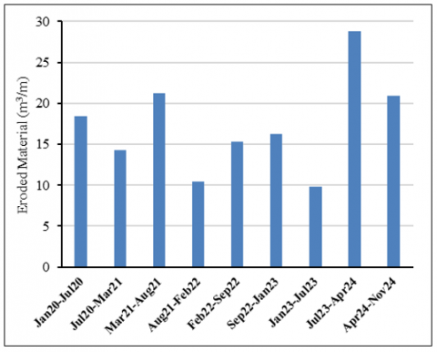
It was clear that erosion phenomena would remain and produce a change in the cross-section geometry during the study period. The value of sediment erosion from the studied station may vary over the duration of this study. Thus, a practical measurement for estimating the amount of eroded material between each record was summarized and illustrated in Figure 14.
Figure 14. The cross-section erosion during the study period
It can be observed from Figure 14 that the difference in eroded areas depends on and varies based on the duration of the measurement and the time of year. Furthermore, during the time of the study, the regular maximum discharge was recorded in the years 2020 and 2021. However, the flood event during the spring of 2024 influenced the amount of sediment eroded from the cross-section and reached its maximum during this time. Finally, the recording of data and monitoring of the station remained for approximately five years, from January 2020 to the end of November 2024, as shown in Figure 14; as evidenced from all these measurements, the extent of riverbank erosion in the river that is determined by comparing the measured profiles over the five years showed the total erosion during this period reached approximately 62 cm.
The erosion rate can be considered slightly high given the current conditions in the region, which influence the erosion processes. Factors such as fluctuating water levels and velocities near the riverbank, along with human activities and the absence of vegetation cover, have all contributed to an increase in the shear stress acting on the riverbank's soil, ultimately leading to the occurrence of erosion. This rate of erosion, if it continues, will lead to further riverbank retreat in the future, necessitating the implementation of precautionary measures to make the riverbank less prone to erosion and, consequently, more stable and safer for the surrounding area. This study focused on establishing a practical process for measuring the amount of erosion in the river cross-section and using the Tigris River in Baiji city as a case study. Several measurements using the Acoustic Doppler Current Profiler (ADCP) for almost five years were recorded. Following that, the river cross-section was plotted to inspect the variation in the geometry and check if the station was subjected to erosion phenomena. The results showed that this portion of the river still had a certain amount of erosion during the study period. This amount varied during the time; however, the maximum erosion occurred following the long period of measurement that happened during the time firm between July 2023 to April 2024.
There are numerous methods to measure and predict riverbank erosion, many of which have been reviewed in this study. It is recommended to use one of these methods and compare the results achieved in the study with the findings of this research. Additionally, it is advised to monitor the riverbank and implement measures that can reduce or prevent erosion in the future, such as planting vegetation on the riverbank, covering it with stones, or lining it with cement mortar, among other measures that help minimize erosion.
[1] Gardiner, T. (1983). Some factors promoting channel bank erosion, River Lagan, County Down. Journal of Earth Sciences, 5(2): 231-239.
[2] Clark, L.A., Wynn, T.M. (2007). Methods for determining streambank critical shear stress and soil erodibility: Implications for erosion rate predictions. Transactions of the ASABE, 50(1): 95-106. https://doi.org/10.13031/2013.22415
[3] Laderoute, L., Bauer, B. (2013). River bank erosion and boat wakes along the lower Shuswap River, British Columbia. Final project report submitted to the Regional District of North Okanagan Fisheries and Oceans Canada. https://www.sensociety.org/s/River_Bank_Erosion_Lower_Shu_River_Final_Project_Report-2013.pdf.
[4] Ahmad, D., Kanwal, M., Afzal, M. (2023). Climate change effects on riverbank erosion Bait community flood-prone area of Punjab, Pakistan: an application of livelihood vulnerability index. Environment, Development and Sustainability, 25(9): 9387-9415. https://doi.org/10.1007/s10668-022-02440-1
[5] National water quality inventory 2000 report. https://www.epa.gov/waterdata/national-water-quality-inventory-report-congress.
[6] Papanicolaou, A.N., Elhakeem, M., Hilldale, R. (2007). Secondary current effects on cohesive river bank erosion. Water Resources Research, 43(12): W12418. https://doi.org/10.1029/2006WR005763
[7] Knighton, D. (2014). Fluvial Forms and Processes: A New Perspective. Routledge.
[8] Wynn, T. (2006). Streambank retreat: A primer. AWRA Hydrology & Watershed Management Technical Committee, Watershed Update, 4(1): 1-14.
[9] Simon, A., Collison, A.J., Layzell, A. (2003). Incorporating bank-toe erosion by hydraulic shear into the ARS bank-stability model: Missouri River, Eastern Montana. In World Water & Environmental Resources Congress, pp. 1-11. https://doi.org/10.1061/40685(2003)359
[10] Langendoen, E.J., Simon, A., Curini, A., Alonso, C.V. (1999). Field validation of an improved process-based model for streambank stability analysis. Water Resources into the New Millennium: Past Accomplishments and New Challenges.
[11] Yass, M.F. (2024). Hydrodynamic-morphological investigation for the riverbank stability of Tigris river within salah al-din governorate. Doctoral dissertation, Tikrit University.
[12] Mohammed-Ali, W., Mendoza, C., Holmes, R.R. (2021). Riverbank stability assessment during hydro-peak flow events: The lower Osage River case (Missouri, USA). International Journal of River Basin Management, 19(3): 335-343. https://doi.org/10.1080/15715124.2020.1738446
[13] Kean, J.W., Kuhnle, R.A., Smith, J.D., Alonso, C.V., Langendoen, E.J. (2009). Test of a method to calculate near-bank velocity and boundary shear stress. Journal of Hydraulic Engineering, 135(7): 588-601. https://doi.org/10.1061/(ASCE)HY.1943-7900.0000049
[14] Khanoosh, A.A., Khaleel, E.H., Mohammed-Ali, W.S. (2023). The resilience of numerical applications to design drinking water networks. International Journal of Design & Nature and Ecodynamics, 18(5): 1069-1075. https://doi.org/10.18280/ijdne.180507
[15] Islam, A., Guchhait, S. K. (2024). Riverbank erosion: A human-induced process. In Riverbank Erosion in the Bengal Delta: An Integrated Perspective, pp. 99-143. https://doi.org/10.1007/978-3-031-47010-3_4
[16] Yass, M.F., Khalaf, R.M. (2025). The applicability of riverbank stability models. Mathematical Modelling of Engineering Problems, 12(2): 577-588. https://doi.org/10.18280/mmep.120221
[17] Posner, A.J., Duan, J.G. (2012). Simulating river meandering processes using stochastic bank erosion coefficient. Geomorphology, 163-164: 26-36. https://doi.org/10.1016/j.geomorph.2011.05.025
[18] Estimated Population of Iraq. Governorates. http://www.cosit.gov.iq.
[19] Midgley, T.L., Fox, G.A., Heeren, D.M. (2012). Evaluation of the bank stability and toe erosion model (BSTEM) for predicting lateral retreat on composite streambanks. Geomorphology, 145: 107-114. https://doi.org/10.1016/j.geomorph.2011.12.044
[20] Mohammed-Ali, W.S., Khaleel, E.H. (2023). Assessing the feasibility of an explicit numerical model for simulating water surface profiles over weirs. Mathematical Modelling of Engineering Problems, 10(3): 1025-1030, https://doi.org/10.18280/mmep.100337
[21] Ahmad, M.F., Dong, P., Mamat, M., Wan Nik, W.B., Mohd, M.H. (2011). The critical shear stresses for sand and mud mixture. Applied Mathematical Sciences, 5(2): 53-71.
[22] Mahmood, K.M., Mohammed-Ali, W.S. (2025). A hydraulic performance model of Khassa chai river under varying flow conditions. Engineering, Technology & Applied Science Research, 15(2): 20934-20940. https://doi.org/10.48084/etasr.9675
[23] Hopkinson, L., Wynn-Thompson, T. (2012). Streambank shear stress estimates using turbulent kinetic energy. Journal of hydraulic research, 50(3): 320-323. https://doi.org/10.1080/00221686.2012.684771
[24] Kean, J.W., Smith, J.D. (2006). Form drag in rivers due to small-scale natural topographic features: 1. Regular sequences. Journal of Geophysical Research: Earth Surface, 111(F4): F04009. https://doi.org/10.1029/2006JF000467
[25] Thompson, A.M., Wilson, B.N., Hansen, B.J. (2004). Shear stress partitioning for idealized vegetated surfaces. Transactions of the ASAE, 47(3): 701-709. https://doi.org/10.13031/2013.16102
[26] Mehta, A.J., Hayter, E.J., Parker, W.R., Krone, R.B., Teeter, A.M. (1989). Cohesive sediment transport. I: Process description. Journal of Hydraulic Engineering, 115(8): 1076-1093. https://doi.org/10.1061/(ASCE)0733-9429(1989)115:8(1076)
[27] Bank Stabilization Design Guidelines. https://www.scribd.com/document/356302412/Bank-Stabilization-Design-Guidelines.
[28] Mohammed-Ali, W.S., Khairallah, R.S. (2023). Flood risk analysis: The case of Tigris river (Tikrit/Iraq). Tikrit Journal of Engineering Sciences, 30(1): 112-118. https://doi.org/10.25130/tjes.30.1.11
[29] Curran, J.H., McTeague, M.L. (2011). Geomorphology and bank erosion of the Matanuska River, southcentral Alaska. No. 2011-5214, US Geological Survey. https://doi.org/10.3133/sir20115214
[30] Constantine, C.R., Dunne, T., Hanson, G.J. (2009). Examining the physical meaning of the bank erosion coefficient used in meander migration modeling. Geomorphology, 106(3-4): 242-252. https://doi.org/10.1016/j.geomorph.2008.11.002
[31] Debnath, K., Nikora, V., Elliott, A. (2007). Stream bank erosion: In situ flume tests. Journal of irrigation and Drainage Engineering, 133(3): 256-264. https://doi.org/10.1061/(ASCE)0733-9437(2007)133:3(256)
[32] Pizzuto, J.E., Meckelnburg, T.S. (1989). Evaluation of a linear bank erosion equation. Water Resources Research, 25(5): 1005-1013. https://doi.org/10.1029/WR025i005p01005
[33] Ikeda, S., Parker, G., Sawai, K. (1981). Bend theory of river meanders. Part 1. Linear development. Journal of Fluid Mechanics, 112: 363-377. https://doi.org/10.1017/S0022112081000451
[34] Tominaga, A., Nezu, I. (1991). Turbulent structure in compound open-channel flows. Journal of Hydraulic Engineering, 117(1): 21-41. https://doi.org/10.1061/(ASCE)0733-9429(1991)117:1(21)
[35] Czernuszenko, W., Holley, E.R. (2007). Open-channel turbulence measurements with a three-component acoustic Doppler velocimeter. Publications of the Institute of Geophysics Polish Academy of Sciences, E-7(401): 49-79.
[36] Abdulrasul, W.A., Mohammed-Ali, W.S. (2024). Experimental study of energy dissipation in sudden contraction of open channels. Instrumentation, Mesure, Metrologie, 23(1): 55-61. https://doi.org/10.18280/i2m.230105
[37] Song, T., Chiew, Y.M. (2001). Turbulence measurement in nonuniform open-channel flow using acoustic Doppler velocimeter (ADV). Journal of Engineering Mechanics, 127(3): 219-232. https://doi.org/10.1061/(ASCE)0733-9399(2001)127:3(219)