Ganjar Oki Widhanarto![]() | Trio Santoso*
| Trio Santoso*![]() | Pradana Wanda Adhitya
| Pradana Wanda Adhitya![]() | Dwi Astiani
| Dwi Astiani![]()
© 2025 The authors. This article is published by IIETA and is licensed under the CC BY 4.0 license (http://creativecommons.org/licenses/by/4.0/).
OPEN ACCESS
Riam Sicangguran Village Forest has a high diversity of flora and fauna. Anticipating the increasing size of community gardens and the decline in the quality of environmental and ecosystem services as well as the decline in biodiversity, zoning management planning needs to provide. The purpose of this research was to find out which areas have the potential to become management zones and core zones based on the results of spatial analysis to make a map of the village forest management plan in the Riam Sicangguran Village Forest, Pangkalan Paket Village, Ketapang Regency, West Kalimantan Province. The spatial analysis method was used in measuring and analyzing orthoimages and survey methods in the ground check process. Overlap analysis on land cover classification map within the contour, slope class, and national forestry plan maps (RKTN) to determine zoning areas for forest management planning. The results showed that the total management area for the core block reached 195.41 hectares, while the utilization block reached 561.68 hectares. The comparison of the management zoning area was dominated by the utilization block by 74% of the total area in the Riam Sicangguran Village Forest management area and 26% in the core block. The primary land cover found in the village forest was determined to be plantations. The RSVF has significant potential for Non-Timber Forest Products (NTFPs) and environmental services.
village forest, zoning management, forest planning, Riam Sicangguran, Ketapang Regency
Forests play a crucial role in maintaining ecological balance by serving as carbon sinks, preserving biodiversity, and providing essential ecosystem services. Sustainable forest management (SFM) has become a global priority to mitigate deforestation, habitat loss, and climate change [1]. In Indonesia, village forests (hutan desa) have been increasingly recognized as a viable approach to balancing conservation and local livelihoods [2]. The Riam Sicangguran Village Forest (RSVF), located within the GRPF in Ketapang Regency, West Kalimantan, is a critical conservation area that supports rich biodiversity while also sustaining local communities through traditional agroforestry practices.
The GRPF is a crucial sanctuary for a diverse range of plant and animal species found in dryland forests. The forest also includes multiple settlements, each with its unique socio-cultural characteristics and established traditions for land usage, such as farming and oil palm production. The inclusion of the Riam Sicangguran Village Forest (RSVF) in the GRPF represents a significant step towards forest management that centered around the community. This approach holds great potential for the sustainable use of resources and the improvement of livelihoods [3, 4].
However, RSVF is facing mounting challenges due to the rapid expansion of community plantations, particularly oil palm and rubber cultivation. While these land-use changes provide short-term economic benefits, they pose significant threats to forest integrity, including biodiversity loss, soil degradation, and reduced ecosystem services [5]. The increasing demand for land has led to a land-use conflict between conservation priorities and community livelihood needs, necessitating an effective spatial zoning strategy to balance these competing interests. The attraction of varying economic benefits derived from palm oil, combined with a limited understanding of sustainable alternatives, has contributed to this incursion [5, 6].
The RSVF is essential for the Pangkalan Paket villagers as it provides vital resources including fruit trees and rubber through the traditional "dahas" or tembawang system. This highlights the complex interaction between the community and the forest [2, 7].
The main difficulty lies in achieving a careful equilibrium between meeting the community's demands for survival and maintaining the crucial goal of preserving the forest [8, 9]. The rapid expansion of community plantations, particularly those cultivating oil palm, has led to significant changes in land cover and widespread deforestation in the GRPF. These issues have raised worries over the decline of environmental services, the loss of biodiversity, and the possible disturbance of the delicate socio-ecological balance in the region [10]. There has been a clear and indisputable need for efficient zoning and management planning in the RSVF.
This work aimed to tackle this urgent issue by utilizing the capabilities of spatial analysis. The objective of the research was to determine and define certain regions within the RSVF that are appropriate for both management and core zones. This will ensure the responsible and long-term use of forest resources, while also protecting vital ecological services [11, 12]. The research also aimed to create a strong zoning plan and a highly comprehensive management map for the RSVF. These will serve as a guiding framework for future conservation and community development efforts, promoting peaceful coexistence between the community and the forest, ensuring that not only are livelihoods maintained, but also improved, and the priceless biodiversity of the RSVF was conserved for future generations [13, 14].
By providing a data-driven zoning framework, this study supports the implementation of Indonesia’s national forest governance policies, particularly within the framework of social forestry programs (Peraturan Menteri LHK No. P.41/MENLHK/SETJEN/ KUM.1/7/2019). Additionally, the integration of community participation in the zoning process enhances the social legitimacy of the proposed management plan, increasing the likelihood of long-term adherence and sustainability.
2.1 Location and time
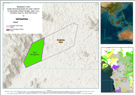
The Riam Sicangguran Village Forest (RSVF) located in the Gunung Raya Protected Forest, Ketapang Regency of the West Kalimantan Province, Indonesia. The forest has an area of around 757 hectares and is situated at a geographical position of 01°58'43.213" South latitude and 110°41'55.412" East longitude. Research location can be seen in Figure 1.
The average yearly temperature ranges from 27.2 to 27.8℃. The average annual rainfall between 2011 and 2020 was 2985 mm, with the lowest recorded at 2016 mm and the highest at 3970 mm. The number of days with precipitation varied from 134 to 265 [15]. Usually, the months of July and August are drier, although in certain years this dry period can extend until September [16].
The nature reserve has a wide range of plant life, including several ecosystems such as lowland forest, heath forest, swamp forest, and mangrove [17]. Based on the Geological Map Sheet Ketapang, Kalimantan 1:250,000, the geological composition of the area consists of Granite, Andesite, Basalt, and Schist rocks and the prevailing soil type is red-yellow podzolic soil, classified as Dystropupis (https://geologi. esdm.go.id/geomap/pages/preview/peta-geologi-lembar-ketapang-kalimantan).
Figure 1. Research location map
2.2 Data collection
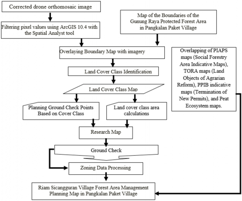
Data collection in this study was carried out by involving several stages carried out simultaneously in the form of Aerial Photography and Image Processing, Land Cover Classification and Ground-truthing and Data Verification. DJI Phantom 4 Pro drone was used, equipped with a 1-inch 20-megapixel (MP) CMOS sensor. The flight missions were pre-programmed with the following parameters to ensure optimal coverage and image quality using parameters:
Aerial Photography and Image Processing
Land Cover Classification
Ground-truthing and Data Verification
2.3 Data analysis
The classified land cover map was overlaid with contour and slope maps generated from topographic data to identify areas suitable for management and core zones [29].
The land cover map was also overlaid with the National Forestry Plan map to ensure compliance with national land-use guidelines from The Regulation of the Minister of Environment and Forestry Number: P.41/MENLHK/SETJEN/KUM.1/7/2019 [30].
The final zoning plan was developed by integrating the results of the spatial analysis with ground-truthing data and considering the socio-economic and cultural context of the RSVF community [31]. Research process and workflow sequentially can be seen in Figure 2.
Although the spatial zoning analysis provided valuable insights, several limitations should be considered the spectral similarity between land cover types may introduce misclassification errors. Seasonal variations in vegetation cover could affect classification accuracy. Drone flight constraints, such as cloud cover and terrain elevation, may lead to minor distortions in the final orthomosaic map. Community land-use dynamics require continuous monitoring to ensure zoning effectiveness. Future studies should incorporate higher-resolution LiDAR data and time-series analysis to enhance the accuracy of forest management planning.
Figure 2. Research workflow
3.1 Land cover classification
The spatial analysis of the forest area in RSFV resulted in the classification of land cover types into six distinct canopy cover classes. The primary dryland forest had the largest canopy cover, spanning 259.60 hectares. It was followed by the secondary dryland forest canopy, which covered 233.78 hectares. Plantations covered 193.31 hectares, old shrubs covered 49.41 hectares, young shrubs covered 17.50 hectares, and there were 3.49 hectares of open land. The classification of land cover in the research area based on spatial analysis can be shown in Table 1.
Based on the Table 1 of the land cover classification carried out in the village forest of Riam Sicangguran, more dominated by primary dryland forest cover types. The data that has been generated from the initial stages of this research then followed by a ground check process to determine the correctness of the land cover classification results carried out on the desk.
The results of ground checks in the field and information from the local Chief Customary on the land cover classification map that has been made, there are land covers that are primary dryland forest types and secondary dryland forests which are identified as old Pedahasan belonging to the Pangkalan Paket village community [32]. So that the identified land cover was classified as plantation land cover. The change in land cover classification aims to be taken into consideration when determining the zoning of village forest management areas. Changes in land cover classification can be seen in Table 2.
The results of the ground inspection were compared to the land cover classification map, revealing a significant change in the type of land cover. The changed land cover was secondary dryland forest and primary dryland forest. Where the cover was identified as Pedahasan or plantation owned by the community. Changes in land cover classification resulting from a comparison of land cover classification adjustments based on Ground check results can be seen in the following Figures 3.
Table 1. Classification of land cover in Riam Ricangguran village forest
|
Land Cover Types |
Spatial Analysis |
Ground Check |
||
|
Area (ha) |
Coverage (%) |
Area (ha) |
Coverage (%) |
|
|
Young Shrub |
17.5 |
2.31% |
17.5 |
2.31% |
|
Old Shrub |
49,41 |
6.53% |
49,41 |
6.53% |
|
Primary Dryland Forest |
259.6 |
34.29% |
143.74 |
18.99% |
|
Secondary Dryland Forest |
233.78 |
30.88% |
106.05 |
14.01% |
|
Plantation |
193,31 |
25.53% |
436.9 |
57.71% |
|
Open Land |
3.49 |
0.46% |
3.49 |
0.46% |
|
Totals |
757.09 |
100.00% |
757.09 |
100.00% |
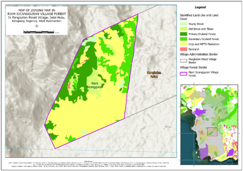
Figure 3. Map of land cover classification in Riam Sicangguran Village Forest based on ground check results
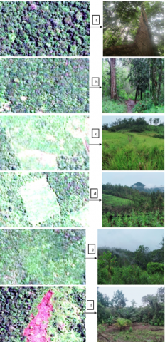
One of the primary challenges in land cover classification is the spectral similarity between different vegetation types, which can lead to misclassification errors [33]. In this study, secondary dryland forests were often spectrally similar to community plantations (Pedahasan), resulting in an overestimation of forested areas in the initial classification. Comparison of land use types, image taken from aerial photograph and ground survey can be seen in Figure 4.
The Maximum Likelihood Classification (MLC) method, while effective, may not fully differentiate mixed land-use patterns, especially when tree canopy cover is continuous. To mitigate these errors, ground-truthing surveys were conducted at 30 sample points, improving classification accuracy from 85% to 92%. However, certain seasonal variations in vegetation reflectance could still affect classification reliability, particularly for distinguishing between old and young shrub formations [24].
3.2 Zoning and management framework
According to the regulations set by the Indonesian Minister of Environment and Forestry. These regulations include Regulation Number 8 of 2021, which focuses on The Regulation of the Minister of Environment and Forestry No. P.41/MENLHK/SETJEN/ KUM.1/7/2019, which outlines the National Forestry Plan from 2011 to 2030. The zoning procedure adopted a comprehensive approach, taking into account many aspects such as land cover, topography, slope, current land use, and the specific requirements of the community. The use of spatial analysis tools, specifically ArcGIS 10.4 and ERDAS Imagine, along with on-site data verification and input from local stakeholders, enabled the division of the RSVF into two main zones:
Figure 4. Comparison of the aerial photograph with ground survey for (a) Primary Dryland Forest; (b) Secondary Dryland Forest/Pedahasan; (c) Young Shrub; (d) Plantation; (e) Old Shrub; (f) Bareland
The high prevalence of the use block (74%) demonstrates the importance of achieving a balance between conservation goals and the socioeconomic welfare of the community. Nevertheless, the incorporation of specific secondary forest and plantation regions inside the central area emphasizes the crucial need to protect biodiversity and ecosystem services, especially in places that have undergone previous human intervention [38].
The management plan for the RSVF was based on the ideals of sustainable resource usage, biodiversity preservation, and community empowerment. The utilization block was designed to facilitate a wide range of livelihood activities, including the development and harvesting of Non-Timber Forest Products (NTFPs), agroforestry, and the growing potential of ecotourism.
The emphasis on Non-Timber Forest Products (NTFPs) underscores its importance in the context of forest management planning and livelihood diversification [39].
The most significant change was observed in primary and secondary dryland forests, which were overestimated in the spatial analysis by 115.86 ha and 127.73 ha, respectively. Conversely, the ground-truthing results showed a substantial increase in plantation areas (243.59 ha). The primary cause of this misclassification was the spectral similarity between secondary dryland forests and community-managed agroforestry plantations (locally known as Pedahasan), which were mistakenly classified as forested areas. This finding underscores the importance of field validation in land cover mapping, as remote sensing alone may fail to capture fine-scale land-use dynamics [40].
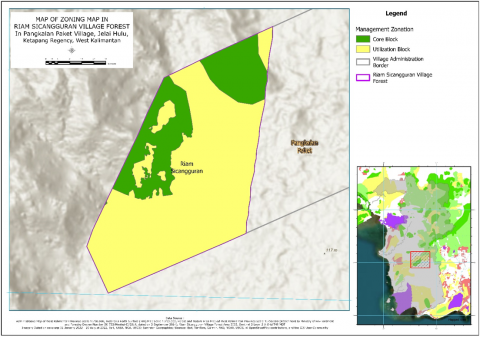
Figure 5. Zoning map of Riam Sicangguran Village Forest management (RSVF)
Table 2. Zoning analysis of Riam Sicangguran Village Forest (RSVF) management for land cover types
|
Management Zoning |
Land Cover Types |
||||||
|
Young Shrub |
Old Shrub |
Primary Dryland Forest |
Secondary Dryland Forest |
Plantation |
Open Land |
Grand Totals |
|
|
Core Block |
4.73 |
3.67 |
116.83 |
26.79 |
42.87 |
0.52 |
195,41 |
|
Utilization Block |
12.77 |
45,74 |
26,92 |
79,26 |
394.03 |
2.97 |
561.68 |
|
Grand Totals |
17.50 |
49,41 |
143.74 |
106.05 |
436.90 |
3.49 |
757.09 |
3.3 Implications for sustainable forest management
The spatial analysis carried out in this research establishes a strong basis for making decisions based on evidence and for the sustainable management of the RSVF. The carefully designed zoning plan and management map are essential tools for the Village Forest Management Institution (LPHD) and the community. They guide their actions and promote a peaceful balance between resource exploitation and conservation. The distinct separation between core and usage zones enables the effective application of focused management techniques, guaranteeing the protection of vital ecosystems while still permitting sustainable livelihood activities. By using spatial data on terrain, slope, and land cover, the plan becomes more successful as it takes into consideration the physical limitations and possibilities [41, 42].
The zoning process highlights the significance of acknowledging and valuing local expertise and ambitions in forest management. By actively engaging the community in the process of making decisions, the plan acquires social legitimacy and promotes a feeling of ownership, which essential for its successful execution and long-term viability [43]. The participatory method enhances the incorporation of traditional ecological knowledge alongside scientific data, resulting in more sophisticated and contextually appropriate management solutions [44].
The capacity of the RSVF to make a substantial contribution to Indonesia's Nationally Determined Contribution (NDC) commitments by serving as a carbon sink and a refuge for biodiversity. The effective stewardship of the RSVF, including the safeguarding and rejuvenation of primary arid forests, can have a crucial impact in alleviating climate change and promoting ecological sustainability [45, 46]. The forest's ability to capture and store carbon and protect biodiversity highlights its significance in the worldwide effort to combat climate change and save natural ecosystems [47, 48].
The emphasis on Non-Timber Forest Products (NTFPs) in the usage sector corresponds to the increasing acknowledgment of their importance in fostering livelihood diversification and sustainable forest management [49]. The RSVF possesses a diverse selection of Non-Timber Forest Products (NTFPs), including rattan, bamboo, and medicinal plants, which have favorable prospects for generating revenue and reducing poverty among residents. Nevertheless, to guarantee the long-term sustainability of livelihoods based on non-timber forest products (NTFPs), it is crucial to implement sustainable harvesting methods and focus on developing the value chain [50, 51].
The findings also have implications for addressing the challenges posed by the growth of oil palm plantations within the RSVF. To effectively manage the environmental impact of plantation lands in both the core and usage blocks, it was essential to identify them and implement measures that encourage their sustainable management. Agroforestry systems, including the integration of multi-purpose tree species (MPTS) with oil palm, present a promising option as they enhance biodiversity, improve soil health, and offer supplementary income opportunities for farmers [52, 53].
The zoning plan and management map could be utilized as a significant model for future conservation and community development endeavors in the RSVF [54, 55]. The plan's focus on sustainable resource utilization, biodiversity conservation, and community empowerment is in line with the ideas of social forestry and sustainable development [56, 57].
The successful implementation and monitoring of the plan will depend heavily on the active participation of the LPHD and the community [58, 59]. The effectiveness of spatial analysis and participative approaches in creating successful zoning and management plans for village forests. It was also important to guide policy and implementation in community-based forest management, promoting a more sustainable and fair approach to the use and preservation of forest resources [53].
The implementation of the zoning plan depends on the alignment with national forestry policies, including Regulation No. P.41/MENLHK/SETJEN/KUM.1 /7/2019, which governs village forest management in Indonesia. However, legal ambiguities regarding customary land rights and social forestry concessions may pose barriers to enforcement [53]. Moreover, stakeholder conflicts between conservation agencies and local communities could hinder the adoption of sustainable forest management practices. Addressing these issues requires:
Incentives for agroforestry-based land management, such as payment for ecosystem services (PES) programs. Strengthening local governance structures to enhance compliance with zoning regulations. Capacity-building initiatives for communities to adopt sustainable land-use alternatives instead of expanding monoculture plantations [52].
The rapid increase in plantation areas (Pedahasan) highlights the growing dependence of local communities on agroforestry systems for their livelihoods. Agroforestry, particularly the cultivation of rubber, fruit trees, and oil palm, provides economic benefits but also raises long-term sustainability concerns [52].
With a total management area of 757.09 ha, the spatial analysis conducted in this research has produced the successful identification of management zones inside the RSVF. Thoughtfully split into a core block mostly used for conservation and spanning 195.41 hectares and a utilization block meant for sustainable resource use and community development 561.68 ha in total. The predominance of plantations inside the RSVF emphasizes the complex interaction between the local inhabitants and their surroundings, therefore stressing the need for sustainable land-use policies promoting both economic well-being and ecological integrity.
Rich possibilities for Non-Timber Forest Products (NTFPs) and environmental services presented by the RSVF provide means of enhancing sustainable livelihoods and reducing poverty. Utilizing their identification and mapping inside the use block, these resources offer a useful framework for their sustainable maintenance and application. Dedicated to protection and restoration, the core block provides a vital defense for the biodiversity and ecological processes of the forest, therefore ensuring the long-term survival and resilience of the ecosystem.
The offered research results provide a strong basis for wise decision-making and environmentally friendly RSVF maintenance. Designed by a collaborative process combining scientific data with local knowledge, the zoning plan and management map offer the Village Forest Management Institution (LPHD) and the community a useful road map. The emphasis of the plan on sustainable resource use, biodiversity protection, and community empowerment fits very well with the ideas of social forestry and sustainable development, so opening the path for a future in which the RSVF thrives as a model of harmonic coexistence between people and nature.
This research highlights the need for more research to fully utilize the forest even while it provides insightful analysis of the management of the RSVF. Future studies could probe the RSVF's capacity for carbon sequestration more thoroughly and pinpoint High Conservation Value (HCV) areas, therefore offering vital data to improve its contribution to national and worldwide climate change mitigating efforts. The dynamic character of socio-ecological systems makes constant monitoring and adaptive management necessary to guarantee the long-term resilience of the zoning plan against changing environmental and socioeconomic circumstances.
The research fellowship program provided support for this research, in collaboration with the Fauna and Flora International Indonesia Program, South Ketapang Forest Management Unit, and the residents of Pangkalan Paket village.
[1] Nugroho, H.Y.S.H., Nurfatriani, F., Indrajaya, Y., Yuwati, T.W., Ekawati, S., Salminah, M., Gunawan, H., Subarudi, S., Sallata, M.K., Allo, M.K., Muin, N., Isnan, W., Putri, I.A.S.L.P., Prayudyaningsih, R., Ansari, F., Siarudin, M., Setiawan, O., Baral, H. (2022). Mainstreaming ecosystem services from Indonesia’s remaining forests. Sustainability, 14(19): 12124. https://doi.org/10.3390/su141912124
[2] Moeliono, M., Thuy, P.T., Bong, I.W., Wong, G.Y., Brockhaus, M. (2017). Social forestry-why and for whom? A comparison of policies in Vietnam and Indonesia. Forest and Society, 1(2): 78-97. https://doi.org/10.24259/fs.v1i2.2484
[3] Senganimalunje, T.C., Chirwa, P.W., Babalola, F.D., Graham, M.A. (2016). Does participatory forest management program lead to efficient forest resource use and improved rural livelihoods? Experiences from Mua-Livulezi Forest Reserve, Malawi. Agroforestry Systems, 90: 691-710. https://doi.org/10.1007/s10457-015-9826-6
[4] Gobeze, T., Bekele, M., Lemenih, M., Kassa, H. (2009). Participatory forest management and its impacts on livelihoods and forest status: The case of Bonga forest in Ethiopia. International Forestry Review, 11(3): 346-358. https://doi.org/10.1505/ifor.11.3.346
[5] Byerlee, D., Falcon, W.P., Naylor, R.L. (2016). The tropical oil crop revolution: Food, feed, fuel, and forests. Oxford University Press. https://doi.org/10.1093/acprof:oso/9780190222987.001.0001
[6] Marin-Burgos, V., Clancy, J.S. (2017). Understanding the expansion of energy crops beyond the global biofuel boom: evidence from oil palm expansion in Colombia. Energy, Sustainability and Society, 7: 1-21. https://doi.org/10.1186/s13705-017-0123-2
[7] Lusiana, B., Widodo, R., Mulyoutami, E. (2008). Assessing hydrological situation of kapuas hulu basin, kapuas hulu regency, West Kalimantan. World Agroforestry Center Working Paper Nr, 60: 78.
[8] Boedhihartono, A.K. (2022). Governance must evolve to meet new needs of Indonesian forest communities. In Sacred Forests of Asia, Routledge, pp. 277-291. https://doi.org/10.4324/9781003143680-25
[9] Houballah, M., Cordonnier, T., Mathias, J.D. (2023). Maintaining or building roads? An adaptive management approach for preserving forest multifunctionality. Forest Ecology and Management, 537: 120957. https://doi.org/10.1016/j.foreco.2023.120957
[10] Ferreira, A.S., Peres, C.A., Dodonov, P., Cassano, C.R. (2020). Multi-scale mammal responses to agroforestry landscapes in the Brazilian Atlantic Forest: the conservation value of forest and traditional shade plantations. Agroforestry Systems, 94(6): 2331-2341. https://doi.org/10.1007/s10457-020-00553-y
[11] Mondal, A., Khare, D., Kundu, S., Mukherjee, S., Mukhopadhyay, A., Mondal, S. (2017). Uncertainty of soil erosion modelling using open source high resolution and aggregated DEMs. Geoscience Frontiers, 8(3): 425-436. https://doi.org/10.1016/j.gsf.2016.03.004
[12] Baskent, E.Z. (2020). A framework for characterizing and regulating ecosystem services in a management planning context. Forests, 11(1): 102. https://doi.org/10.3390/f11010102
[13] Jenkins, M., Salzman, J., Bennett, G., Granfors, J. (2020). Making the priceless valuable: forests and ecosystem services. International Forestry Review, 22(1): 104-112. https://doi.org/10.1505/146554820829523998
[14] Dawson, N., Carvalho, W.D., Bezerra, J.S., Todeschini, F., Tabarelli, M., Mustin, K. (2023). Protected areas and the neglected contribution of Indigenous Peoples and local communities: Struggles for environmental justice in the Caatinga dry forest. People and Nature, 5(6): 1739-1755. https://doi.org/10.1002/pan3.10288
[15] Zakaria, A., Wakker, E., Theile, C. (2009). Failing governance—avoiding responsibilities European biofuel policies and oil palm plantation expansion in Ketapang District, West Kalimantan (Indonesia). Friends of the Earth Netherlands (Milieudefensie) and WALHI Kalimantan Barat, Indonesia, 30: 29.
[16] Widayati, A., Louman, B., Mulyoutami, E., Purwanto, E., Kusters, K., Zagt, R. (2021). Communities’ adaptation and vulnerability to climate change: Implications for achieving a climate-smart landscape. Land, 10(8): 816. https://doi.org/10.3390/land10080816
[17] Soendjoto, M.A., Riefani, M.K., Diana, S.H.E.R.L.I. (2023). Floristic diversity and composition of kuala tambangan heath forestin tanah laut district, South Kalimantan, Indonesia. Biodiversitas, 24(10): 5418-5427. https://doi.org/10.13057/biodiv/d241024
[18] Hidayat, M.A., Sudarsono, B. (2016). Pemodelan pertumbuhan tata ruang Kota Semarang berdasarkan aspek ekonomi menggunakan konsep analisis spasial citra satelit resolusi tinggi. Jurnal Geodesi Undip, 5(3): 61-69. https://doi.org/10.14710/jgundip.2016.12823
[19] Carpenter, S., Byfield, V., Felgate, S.L., Price, D.M., Andrade, V., Cobb, E., Evans, C. (2022). Using unoccupied aerial vehicles (UAVs) to map seagrass cover from Sentinel-2 imagery. Remote Sensing, 14(3): 477. https://doi.org/10.3390/rs14030477
[20] Simpson, J.E., Wooster, M.J., Smith, T.E., Trivedi, M., Vernimmen, R.R., Dedi, R., Dinata, Y. (2016). Tropical peatland burn depth and combustion heterogeneity assessed using UAV photogrammetry and airborne LiDAR. Remote Sensing, 8(12): 1000. https://doi.org/10.3390/rs8121000.
[21] Finn, A., Peters, S., Kumar, P., O’Hehir, J. (2023). Automated georectification, mosaicking and 3D point cloud generation using UAV-based hyperspectral imagery observed by line scanner imaging sensors. Remote Sensing, 15(18): 4624. https://doi.org/10.3390/rs15184624
[22] Martínez-Fernández, A., Serrano, E., Pisabarro, A., Sánchez-Fernández, M., de Sanjosé, J.J., Gómez-Lende, M., Benito-Calvo, A. (2022). The influence of image properties on high-detail SfM photogrammetric surveys of complex geometric landforms: The application of a consumer-grade UAV camera in a rock glacier survey. Remote Sensing, 14(15): 3528. https://doi.org/10.3390/rs14153528
[23] Pepe, M., Domenica, C. (2020). Techniques, tools, platforms and algorithms in close range photogrammetry in building 3D model and 2D representation of objects and complex architectures. Computer-Aided Design and Applications, 18(1): 42-65. https://doi.org/10.14733/cadaps.2021.42-65
[24] Zylshal, Z., Wirawan, R., Kushardono, D. (2018). Assessing the potential of LAPAN-A3 data for landuse/landcover mapping. The Indonesian Journal of Geography, 50(2): 184-196. https://doi.org/10.22146/ijg.31449
[25] Wondrade, N., Dick, Ø.B., Tveite, H. (2014). GIS based mapping of land cover changes utilizing multi-temporal remotely sensed image data in Lake Hawassa Watershed, Ethiopia. Environmental Monitoring and Assessment, 186: 1765-1780. https://doi.org/10.1007/s10661-013-3491-x
[26] Miranda, E., Aryuni, M. (2021). Klasifikasi tutupan lahan menggunakan convolutional neural network pada citra satelit sentinel-2. Sistemasi, 10(2): 323-335. https://doi.org/10.32520/stmsi.v10i2.1226
[27] Wijewardhana, A.M.C., Senevirathna, E.M.T.K. (2024). Applying geo-spatial techniques to determine the temporal variation and conversion pattern of land-use surrounding negombo lagoon. Vidyodaya Journal of Humanities and Social Sciences, 9(1): 133-143. http://doi.org/10.31357/fhss/vjhss.v09i01.08
[28] Zeferino, L.B., de Souza, L.F.T., do Amaral, C.H., Fernandes Filho, E.I., de Oliveira, T.S. (2020). Does environmental data increase the accuracy of land use and land cover classification? International Journal of Applied Earth Observation and Geoinformation, 91: 102128. https://doi.org/10.1016/j.jag.2020.102128
[29] Susilo, A., Fitriah, F., Ayu Rachmawati, E.T., Suryo, E.A. (2020). Analysis of landslide area of Tulung subdistrict, Ponorogo, Indonesia in 2017 using resistivity method. Smart and Sustainable Built Environment, 9(4): 341-360. https://doi.org/10.1108/SASBE-06-2019-0082
[30] Almaghfiroh, C.F., Pujo, P. (2023). Analisis kelembagaan skema izin pemanfaatan hutan perhutanan sosial pada kawasan hutan lindung Gunung Rakutak Jawa Barat. Wanamukti: Jurnal Penelitian Kehutanan, 26(2): 76-94. https://doi.org/10.35138/wanamukti.v26i2.613
[31] Warth, G., Braun, A., Assmann, O., Fleckenstein, K., Hochschild, V. (2020). Prediction of socio-economic indicators for urban planning using VHR satellite imagery and spatial analysis. Remote Sensing, 12(11): 1730. https://doi.org/10.3390/rs12111730
[32] Bamba, J., Munandar, A. (2023). Dahas: Innovations in shifting cultivation by the Dayak of West Kalimantan to fight deforestation and climate change. In Farmer Innovations and Best Practices by Shifting Cultivators in Asia-Pacific, GB: CABI, pp. 307-328. https://doi.org/10.1079/9781800620117.0015
[33] Congalton, R.G., Green, K. (2019). Assessing the Accuracy of Remotely Sensed Data: Principles and Practices. CRC Press.
[34] Mashizi, A.K., Sharafatmandrad, M. (2023). Dry forests conservation: A comprehensive approach linking ecosystem services to ecological drivers and sustainable management. Global Ecology and Conservation, 47: e02652. https://doi.org/10.1016/j.gecco.2023.e02652
[35] Fremout, T., Thomas, E., Gaisberger, H., Van Meerbeek, K., Muenchow, J., Briers, S., Muys, B. (2020). Mapping tree species vulnerability to multiple threats as a guide to restoration and conservation of tropical dry forests. Global Change Biology, 26(6): 3552-3568. https://doi.org/10.1111/gcb.15028
[36] Purwadi, R., Adisasmito, S., Pramudita, D., Indarto, A. (2023). Strategies for restoration and utilization of degraded lands for sustainable oil palm plantation and industry. Agroecological Approaches for Sustainable Soil Management, 17: 373-408. https://doi.org/10.1002/9781119911999.ch17
[37] Rowland, D., Zanello, G., Waliyo, E., Ickowitz, A. (2022). Oil palm and gendered time use: A mixed-methods case study from West Kalimantan, Indonesia. Forest Policy and Economics, 137: 102682. https://doi.org/10.1016/j.forpol.2021.102682
[38] Hoffmann, S. (2022). Challenges and opportunities of area-based conservation in reaching biodiversity and sustainability goals. Biodiversity and Conservation, 31(2): 325-352. https://doi.org/10.1007/s10531-021-02340-2
[39] Miina, J., Kurttila, M., Calama, R., de-Miguel, S., Pukkala, T. (2020). Modelling non-timber forest products for forest management planning in Europe. Current Forestry Reports, 6: 309-322. https://doi.org/10.1007/s40725-020-00130-7.
[40] Xiong, J., Thenkabail, P.S., Gumma, M.K., Teluguntla, P., Poehnelt, J., Congalton, R.G., Thau, D. (2017). Automated cropland mapping of continental Africa using Google Earth Engine cloud computing. ISPRS Journal of Photogrammetry and Remote Sensing, 126: 225-244. https://doi.org/10.1016/j.isprsjprs.2017.01.019
[41] Maxwell, A.E., Shobe, C.M. (2022). Land-surface parameters for spatial predictive mapping and modeling. Earth-Science Reviews, 226: 103944. https://doi.org/10.1016/j.earscirev.2022.103944
[42] Coruhlu, Y.E., Solgun, N., Baser, V., Terzi, F. (2022). Revealing the solar energy potential by integration of GIS and AHP in order to compare decisions of the land use on the environmental plans. Land Use Policy, 113: 105899. https://doi.org/10.1016/j.landusepol.2021.105899
[43] Zhang, Z., Yu, J., Tian, J. (2024). Community participation, social capital cultivation and sustainable community renewal: A case study from Xi’an’s southern suburbs, China. Journal of the Knowledge Economy, 15(3): 11007-11040. https://doi.org/10.1007/s13132-023-01536-x
[44] Adade Williams, P., Sikutshwa, L., Shackleton, S. (2020). Acknowledging indigenous and local knowledge to facilitate collaboration in landscape approaches—Lessons from a systematic review. Land, 9(9): 331. https://doi.org/10.3390/land9090331
[45] Gupta, S.R., Dagar, J.C., Teketay, D. (2020). Agroforestry for rehabilitation of degraded landscapes: achieving livelihood and environmental security. Agroforestry for Degraded Landscapes: Recent Advances and Emerging Challenges, 1: 23-68. https://doi.org/10.1007/978-981-15-4136-0_2
[46] Stavi, I., Xu, C., Argaman, E. (2024). Climate-smart forestry in the world’s drylands: A review of challenges and opportunities. The Anthropocene Review, 11(1): 67-90. https://doi.org/10.1177/20530196231182354.
[47] Rajasugunasekar, D., Patel, A.K., Devi, K.B., Singh, A., Selvam, P., Chandra, A. (2023). An integrative review for the role of forests in combating climate change and promoting sustainable development. International Journal of Environment and Climate Change, 13(11): 4331-4341.
[48] Di Sacco, A., Hardwick, K.A., Blakesley, D., Brancalion, P.H., Breman, E., Cecilio Rebola, L., Antonelli, A. (2021). Ten golden rules for reforestation to optimize carbon sequestration, biodiversity recovery and livelihood benefits. Global Change Biology, 27(7): 1328-1348. https://doi.org/10.1111/gcb.15498
[49] Kurniati, D., Trison, S. (2023). Analysis of stakeholders’ interest and influence in non-timber forest products marketing: A case study in the forest management unit batutegi, lampung. Jurnal Sylva Lestari, 11(3): 454-472. https://doi.org/10.23960/jsl.v11i3.718
[50] Van Nguyen, T., Lv, J.H. (2021). Factors determining upland farmers' participation in non-timber forest product value chains for sustainable poverty reduction in Vietnam. Forest Policy and Economics, 126: 102424. https://doi.org/10.1016/j.forpol.2021.102424
[51] Sharma, R., Bharti, N. (2020). Non-timber forest products value chain toward sustainable livelihood: Exploring linkages and trends using visual optimization network analysis. Asian Journal of Agriculture and Development, 17(2): 105-118. https://doi.org/10.22004/ag.econ.307981
[52] Roslinda, E., Prisila, F.W., Mariani, Y. (2023). The patterns of agroforestry and its contribution to the community income. Jurnal Sylva Lestari, 11(3): 543-557. https://doi.org/10.23960/jsl.v11i3.749
[53] Santoso, T., Darmawan, A., Sari, N., Syadza, M.A.F., Himawan, E.C.B., Rahman, W.A. (2023). Clusterization of agroforestry farmers using K-means cluster algorithm and elbow method. Jurnal Sylva Lestari, 11(1): 107-122. https://doi.org/10.23960/jsl.v11i1.646
[54] Wiratno, W., Withaningsih, S., Gunawan, B., Iskandar, J. (2022). Ecotourism as a resource sharing strategy: Case study of community-based ecotourism at the Tangkahan Buffer Zone of Leuser National Park, Langkat District, North Sumatra, Indonesia. Sustainability, 14(6): 3399. https://doi.org/10.3390/su14063399
[55] Tsani, M.K., Surnayanti, Santoso, T. (2023). Development of community forests as locations for honey bee cultivation based on potential feed sources: Case study of Mataram village community forests, Indonesia. Forestry Ideas, 29(1): 62-73. https://doi.org/10.5555/20230503016
[56] Harianto, S.P., Winarno, G.D., Tsani, M.K., Santoso, T. (2020). Development strategy for ecotourism management based on feasibility analysis of tourist attraction objects and perception of visitors and local communities. Biodiversitas Journal of Biological Diversity, 21(2): 689-698. https://doi.org/10.13057/biodiv/d210235
[57] Irawan, N.C., Esthi, R.B. (2024). Fostering community participation: The role of forestry extension officers in maximizing social capital for national park conservation. Jurnal Sylva Lestari, 12(1): 54-75. https://doi.org/10.23960/jsl.v12i1.752
[58] Octavia, D., Suharti, S., Murniati, Dharmawan, I.W.S., Nugroho, H.Y.S.H., Supriyanto, B., Ekawati, S. (2022). Mainstreaming smart agroforestry for social forestry implementation to support sustainable development goals in Indonesia: A review. Sustainability, 14(15): 9313. https://doi.org/10.3390/su14159313
[59] Gunawan, H., Yeny, I., Karlina, E., Suharti, S., Murniati, Subarudi, Nurlia, A. (2022). Integrating social forestry and biodiversity conservation in Indonesia. Forests, 13(12): 2152. https://doi.org/10.3390/f13122152