Cédric Djomo Chimi*![]() | Jolie Claire Noudem
| Jolie Claire Noudem![]() | Jules Christian Zekeng
| Jules Christian Zekeng![]() | Loïc Alphonse Tientcheu Tcheugoue
| Loïc Alphonse Tientcheu Tcheugoue![]() | Roger Bruno Tabue Mbobda
| Roger Bruno Tabue Mbobda![]() | Louis Paul Roger Banoho Kabelong
| Louis Paul Roger Banoho Kabelong![]() | Guylène Ngoukwa
| Guylène Ngoukwa![]() | Dieudonné Onana
| Dieudonné Onana![]() | Louis Zapfack
| Louis Zapfack![]()
© 2024 The authors. This article is published by IIETA and is licensed under the CC BY 4.0 license (http://creativecommons.org/licenses/by/4.0/).
OPEN ACCESS
In the perspective to valorize forest ecosystem through the REDD+ mechanism, the Belabo-Diang Massif Forest (BDMF), previously communal forest area in Cameroon, was recently reclassified as an integral ecological reserve after a strong degradation due to anthropic pressure. To assess the future impact of this reclassification, the objective of this study is to predict the future trend of carbon stock's potential of the BDMF in the absence of logging. Methodologically, the carbon stocks estimation for the year 2020 is based on botanical inventory data make with 56 plots of 50 m × 50 m each. Carbon mapping and future trends of carbon stocks for the year 2050 were done using field data and remote sensing. Results show that carbon stocks in BDMF varied from 0 to 262 MgC.ha-1 based to land cover. The carbon stocks of classed [50-100] was the most represented with an area of 22,041.15 ha (37%). The weak area was represented by the carbon class >200 MgC.ha-1 (876.7 ha, 1.1%). The total carbon stocks of BDMF in 2020 is 5,916,337 MgC, and it is estimated in 2050 at 4,821,140 MgC when ecological events like regeneration, ecologically succession and absence of degradation and deforestation are considered. The finding of this study represents a crucial information that can help in accomplishment of efforts to implement climate mitigation initiatives like REDD+ as it can serve as incentive develop a payment for ecosystem services like those of climate regulation.
carbon stocks, global warming, future prediction, Belabo-Diang Massif Forest, Cameroon
Tropical forests play an essential role in the environment and for humans, providing several assets and benefits such as food, timber, and climate regulation. They are also important carbon sinks, hosting high biodiversity and providing ecosystem services [1, 2]. Indeed, it contributes to reducing atmospheric CO2, which is one of the most greenhouse gases (GHGs) present in the atmosphere at a percentage of 0.04% and accounts for 25% of GHG [3]. However, due to human activities (e.g., industrialization, forest conversion, logging, etc.) increase atmospheric carbon dioxide levels by 15%-20% of GHGs emissions [4] and contribute to climate change [5], forests can also be carbon sources [6]. To combat the effects of global warming, which are becoming more apparated worldwide, several measures have been taken to mitigate the fight against climate change. Unanimous forests ecosystems are recognized as a solution to climate change through their capacity to absorb CO2 in the atmosphere and store it in their tissues like biomass [7]. In Congo basin forest, researchers [8] showed that these forests store approximately 250 billion tons of carbon alone; and which is equivalent to 90 years of global emissions of fossil fuels at today's level [9]. Despite its challenges, quantifying the amount of biomass and carbon stored in these ecosystems is crucial for global efforts to reduce climate change, such as the "Reducing emissions from deforestation and forest degradation and the role of conservation of forest carbon, sustainable management of forests and enhancement of forest carbon stocks in developing countries" (REDD+) initiative.
Under this REDD+ initiative, it was decided at Conferences of Parties (COP21 in 2015 at Paris) to incorporate the mechanism of reducing emissions from deforestation and forest degradation (REDD+) into the global climate regime of the Intergovernmental Panel on Climate Change (IPCC). Also, they have agreed for a mobilization of US$100 billion that should be provided up to 2025 for developing countries to help them in the implementation of policies, strategies, regulation and actions plan in favor with climate change mitigation [10]. To become effective, participating countries need to develop national strategies that ensure efficient and precise Monitoring, Reporting and Verification (MRV) of emission reductions that depend on carbon mapping [11], multiples drivers of land-use change and associated with carbon stocks change [12]. In this process, according to the study [13], the researchers found an important opportunity for REDD+ concerning African forest due to their high potential in term of carbon storage, and then climate change mitigation. This opportunity is considered among the factors that motivate several countries to convert many exploited forest areas or not into protected areas. In addition to offsetting emissions, REDD+ mechanism could provide indirect support for biodiversity conservation through reduced habitat loss, thus providing a unique solution to the longstanding tension between conservation interests and other land-use needs in tropical forest regions [3, 4, 9, 10].
Managing landscapes for carbon storage and sequestration require information about volume and location of already stored carbon, quantity of carbon sequestered or lost over time, and relationship between land use change and its effect on carbon storage and sequestration over time [13]. Changes in land use may affect the climate while climate change will also influence opportunities for future land use [14], suggesting an important opportunity for REDD+ [10]. Changes in land use may affect climate change, while climate change will also influence opportunities for future land use [14], suggesting an important opportunity for REDD+ [10]. To face to this situation, many countries of Congo Bassin have opted to protect their natural ecosystems. In Cameroon, these twenty last year, the management of forest was especially focused to logging without that not guaranteeing truly their sustainability, it seems to get clear today, like a new interest for the natural restoration and the afforestation [15]. In fact, sustainable logging contributes to managing and restoring ecosystem services, such as regulation services [1], and then helps in the implementation of the MRV protocol. Therefore, it cannot be processed without a real estimation or poor knowledge about carbon stocks the potential in natural ecosystems. Limited information is available for its implementation. That is why in the previous decades, several pilot projects were implemented, and their results guided the implementation of REDD+ mechanism.
It has been proven that unsustainable management has a negative impact on forest sustainable management. This point of view is also perceptible in Belabo-Diang Massif Forest (BDMF) formerly communal forest where the degradation and deforestation rate were estimated at 0.29% and 3.03% respectively according to spatio-temporal data analysis from 1984 to 2020 [16]. This was due to the high level of forest timber extraction and the conversion of forest areas in the periphery of BDMF by riparian people on agricultural land [16]. Like that, it appears impossible to guarantee the long-term preservation of this forest massif seeing the dynamic of anthropogenic activities developed around it [15], making the consideration of measures that can help it preservation.
With the high level of degradation of BDMF, the ministry in charge of forest of Cameroon was reclassified in the year 2020 this area formerly communal forest in integral ecological reserve with the aim to promote it natural reconstitution. In addition to reconstitution of BDMF, this reclassification appears like an opportunity for REDD+ initiative according to future positive carbon gaps that it can provide. Nevertheless, lack information about carbon stock's potential in BDMF are available. Furthermore, this can indirectly provide support for biodiversity conservation through reduced habitat loss. In term of carbon market, seeing the carbon accumulation in the forest ecosystem that could suggest the approximate amount of carbon that deforestation may release [17], this study was initiate in the aim to predict the future potential of BDMF in terms of carbon stocks when human activities are prohibited and ecological succession promoting. With the hypothesis that the BDMF reconstitute itself in the absence of any human activities, the objectives of the current study are to (i) estimate the current potential of BDMF in term of carbon stocks; (ii) establish carbon mapping of BDMF and (iii) predict the carbon stocks potential of this area in 2050 seeing it implication in the REDD+ initiative.
2.1 Study area
This study was carried out in the Belabo-Diang Forest Reserve (BDFR) located in the Belabo and Diang Sub-division, Lom and Djerem Division of the East Region of Cameroon. It is geographically situated at latitude 4°36-5°06 North and longitude 13°17-13°38 East, covering a total area of 59,213 ha. This study area's climate is equatorial Guinean, characterized by two dry and two rainy seasons with unequal repartition. The relief presents an altitude range of 600-800 m. Soils are essentially ferralitic and hydromorphic in some specific areas, such as near the swamp ecosystem. The temperature average is 24°C and the annual precipitation averages is 1,800 mm. The vegetation of this area is typically a tropical moist semi-deciduous forest close to the transition forest-Savanah [18]. Economically, it is a source of several goods and services for surrounding people where they practice some activities like agriculture, Non-Timber Forest Products (NTFPs) harvesting, hunting, small trade, fishing, and livestock that they are required for their well-being [15]. Also, it is a rich area in terms of timber species, which contributes to the massif forest degradation due to their logging.
2.2 Sampling design
The sampling design used in the context of this study was those recommend by Ngoufo et al. [19] in the context of carbon mapping which was constituted by 56 plots of 50 m × 50 m (14 ha). These 50 m × 50 m plots were chosen according to the spatial resolution unit of LandSat8 images from BDMF used for land cover mapping [16]. To achieve success in carbon mapping, it is recommended to have a sampling design unit (plot size) higher than those of one pixel (spatial resolution). Thus, with land cover of BDMF obtain through landsat image treatment using Qgis software, and that provide forest cover densities constituted by BDMF through the greyscales, the 56 plots were then randomized in the BDMF according to the different land cover identified. Indeed, our previous research found that the BDMF is composed of the following land covers: old secondary forest, raphiale and swamps, young secondary forest, fallow, agroforestry, and crops land. All the geographical coordinate of these randomized samples points were upload in the GPS and with the option “Go to”, it was used to identified each sampled plots where botanical data was collected.
2.3 Data collection
Data collection was done in each randomized plot established. These data collection were focused especially geographical coordinates using a Global Positioning Systems (GPS) Garmin 64s map, land cover identification based on the visual assessment of physiognomic and ecological characteristics, botanical inventory of all trees with a diameter ≥ 5 cm at 1.3 m above the soil using the diameter-tape. The scientific, vernacular and/or commercial names of each tree were recorded based to their discriminants characteristics; tree samples (leaves, barks, fruits) of species for which their name was not identified was collected, drying and conserve in alchool (70°). They were used lated to confirm the identification at the National Herbarium of Yaoundé (Cameroon). Also, the density of all individual trees was recorded in function of species found in these plots. Botanical inventory data was used to estimate Aboveground Biomass (AGB) using non-destructive method.
2.4 Carbon stock estimation
AGB was estimated using the site-specific allometry equation of Djomo and Chimi [20]. It is defined by:
$\operatorname{AGB}(\mathrm{kg})=\mathrm{e}^{(-1.836+2.619 \times \ln (\mathrm{D})+1.268 \times \ln (\rho))}$ (1)
where, ρ = wood density of the species; D = diameter of the tree (cm). Wood density of each tree was based on local wood density if available, and otherwise on wood density obtained from the Global Wood Density Database [21, 22]; wood density averaged (of species where wood density is available) per plot was used. Also, it is a site-specific equation that was developed for semi-deciduous rain forest of East Cameroon and this area correspond to those where data were collected in the context of this study. The estimated AGB was extrapolated to the hectare for each plot using the extrapolation coefficient. The following formulae was used for estimation of carbon stock:
$\mathrm{AGB}\left(\mathrm{MgC} \cdot \mathrm{ha}^{-1}\right)=0.47 \times \mathrm{AGB}\left(\mathrm{Mg} \cdot \mathrm{ha}^{-1}\right)$ (2)
2.4.1 Carbon mapping in the Belabo-Diang Massif Forest
The combination and allocation method (Figure 1) described by Goetz et al. [23] was used to map the carbon in this study. This method has been successfully used by several authors for carbon mapping in certain tropical rainforests in Cameroon [11, 19]. Thus, to extend carbon stock estimates obtained from field data, the simplest approach to carbon stock mapping involves using a variety of data sets and spatial information. In fact, two types of basic data were used in this context: the geographical coordinates (GPX format) of the various sample plots recorded and the estimated correspondence of their carbon stocks (MgC.ha-1) and the land cover vector file produced by classification of the Landsat 8 satellite image [16]. Carbon stock mapping was carried out using QGIS software in four keys steps based on this data:
Step 1: Importing data. This enabled us to import the validated land cover vector file and the GPX carbon stock data into the QGIS software, using the same reference coordinate system as GWS 84.
Step 2: Data intersection. This step enabled a spatial intersection to be made between the land cover data and the carbon stock data, with the aim of assigning the overall sum of the associated carbon stock for each land cover class.
Step 3: Spatial join on the intersected data. This operation enabled a join to be made between each intersected data item in order to obtain the average carbon stock per land cover unit.
Step 4: Interpolation of results. This stage was used to perform a spatial interpolation (IDW method) in order to generalise all the results from the spatial join over the entire study area.
Step 5: Symbology and class categorisation. This step was useful in order to apply a colour palette to each class according to the average quantity of carbon stock sequestered in the study area as a whole.
Figure 1. Simplified methodology used for land cover and carbon mapping
Finally, the carbon map established enabled us to estimate total carbon stocks as a function of carbon class:
- zone with 0-50 MgC.ha-1;
- zone with 50-100 MgC.ha-1;
- zone with 100-150 MgC.ha-1;
- zone with 150-200 MgC.ha-1;
- zone with more than 200 MgC.ha-1.
2.4.2 Future predictions trend of carbon stocks of BDMF
According to the carbon stocks class BDMF found through carbon mapping, we focused on the hypothesis that for a natural area which was not been perturbed for a long time and which is more corroborated with a mature secondary forest (or old secondary forest), mean carbon stock is up than 200 MgC.ha-1 [13, 24]. So then, with the reclassification as integral ecological reserve of this area to favor its natural regeneration, we will be based on the fact that this will favorite to less carbon class to be reconstitute through ecological succession and then become later old or mature secondary forest.
Then the idea will be to consider the required years for an area with 0-50 MgC.ha-1 corresponding to culture and young fallow in an old secondary forest. It is important to know that with ecological succession, approximately 30 years are required to reconstitute a site (Forest Law of Cameroon of 1994). It is for that reason that we have considered a prediction until 2050.
Seeing that we found that carbon stocks of class [150-200] and up to 200 MgC.ha-1 correspond to the natural ecosystem like swamps/raphiales and old mature forests, we suppose that any change according to their carbon capacity will be changed and we were focused only on the 3 first carbon classes to make the prediction. Then, for the class [100-150] that correspond to those of young forest and agroforest ecosystems, Rozendaal et al. [24] showed that the average time required for regrowth of the degraded/logged forests is less or equal to 20 years old. For old fallow, it needed an average 10 years to be a young forest (to say 30 years to be an old forest) and finally, those of agricultural land (crops lands) required ≥100 years to be old mature forest. Based on that information, a linear regression was used to predict carbon stocks in 2050 using the current and target carbon stocks (MgC.ha-1), as well as the required years.
3.1 Carbon stocks Belabo Diang Massif Forest
The carbon stocks in BDMF varied from 0 to 262 MgC.ha-1 in the BDMF in the function of greyscales according to the sampling design used. BDMF is a part of a semi-deciduous forest that is viewed as an ecosystem with high carbon potential [1, 12, 25, 26]. Regarding carbon stock variation according to land cover, Kabelong Banoho et al. [26] have found similar results in their work in Deng-Deng National Park, which also belongs to the semi-deciduous rain forest [18]. This study demonstrated that the carbon stock’s variation is influenced by land cover. According to the study [27], carbon stock variation within an ecosystem is influenced by vegetation type, microclimate, and forest structure.
3.2 Carbon mapping of BDMF
Figure 2 shows the carbon mapping of BDMF. It was discovered that carbon stocks fluctuated based on a gradient from light blue (low carbon stocks) and to dark red (high carbon stocks). The total carbon stocks of this BDMF are estimated to be 5,916,337 MgC. The carbon stocks were divided into 5 carbon classes (Table 1). The carbon class [50-100] MgC.ha-1 covers a high area, either 22,041.15 ha representing 37.1% of the BDMF compared to others. Nevertheless, the carbon class [100-150] has 2,745,196 MgC representing the higher carbon stocks in the BDMF. The class representing the carbon >200 MgC.ha-1 is represented by only 638.70 ha (1.1%) with total carbon stocks estimated at 127,680 MgC.
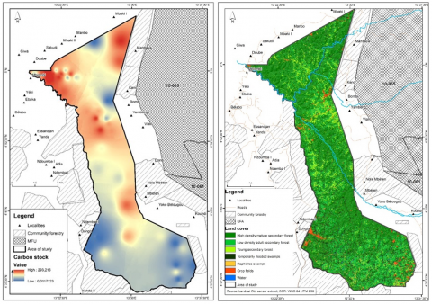
Figure 2. Land cover and carbon mapping of Belabo-Diang Massif Forest
Table 1. Distribution of carbon stocks per carbon class in the BDMF
|
Carbon Stock Class (MgC.ha-1) |
Carbon Stocks Median or Class Center (MgC.ha-1) |
% |
Area Cover (ha) |
Total Carbon Stock (MgC) in 2020 |
|
[0-50] |
25 |
13.5 |
8,044.85 |
201,121.25 |
|
[50-100] |
75 |
37.1 |
22,041.15 |
1,653,086.25 |
|
[100-150] |
125 |
36.9 |
21,961.57 |
2,745,196.25 |
|
[150-200] |
175 |
11.4 |
6,795.73 |
1,189,253.75 |
|
>200 |
200 |
1.1 |
638.70 |
127,680.00 |
|
Total |
100.0 |
59,481.70 |
5,916,337.50 |
|
The correlation between carbon stock class and land cover correspondence was discovered (Figure 2). Superposition between carbon mapping and land cover of BDMF permits us to find the following similarity: carbon stocks with a carbon – class of 0-50 MgC.ha-1 correspond to bare soils, cultures and young fallow; those of 50-100 MgC.ha-1 correspond to old fallow; 100-150 MgC.ha-1 correspond to agroforest and young forest; 150-200 MgC.ha-1 correspond to other natural land covers like swamps and raphiales; finally, highly dense mature secondary forest with carbon up than 200 MgC.ha-1. Others studies have confirmed this this trend in the distribution of carbon stocks on cover type [26].
In a recent study conducted in the Dimako communal forest of Eastern Cameroon, a semi-deciduous rain forest, Hubert et al. [11] found also a correlation between land cover and carbon stock mapping. In this study, we found similar results showing that carbon stock estimated in the function of the greyscales is similar to the different land cover constituted by this BDMF (Figure 2).
3.3 Futures carbon prediction trend
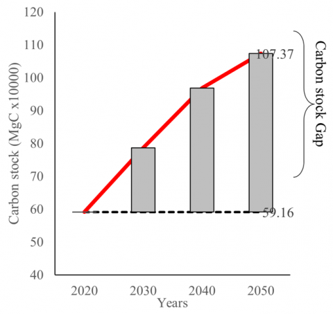
The total carbon stock of the BDMF is estimated at 5,916,337 MgC in 2020, corresponding to the year when it was reclassified as a reserve. For the year 2050, carbon stock potential for this BDMF will be estimated at 10,737,477 MgC; for a carbon, gap estimated at 4,821,140 MgC in 30 years (2020-2050) (Figure 3) in the absence of logging and in favor of ecological succession dynamic, natural regeneration, etc. For Dumitrascu et al. [14], exploring the future potential changes in the forest-cover pattern can help to estimate the trend of forest carbon stock in a specific area, like it was the case in this study for BDMF.
Figure 3. Carbon stock of BDMF prediction for the year 2050
3.4 Implication in climate change initiative: Case of REDD+
Seeing the current world's global warming, Cameroon's forests are counted among the major ecosystems of the Congo basin that play a significant role in climate change mitigation according to this capacity to store the atmospheric CO2 [1, 20]. Therefore, carbon stock's quantification coupled with strategies that can help with the time increasing of this carbon stock potential by these ecosystems has become an international priority in implementing of several initiatives mechanisms like the REDD+ [28]. This REDD initiative was an impetus in 2005 during the Cop11 and where it was mainly focused on the reduction of emission due to degradation and deforestation of the forest, have increasing with time and presently have incorporated the notion of carbon stocks conservation, sustainable management of forest and reinforce the capacity of forest in carbon storage. Under the REDD+ mechanism, carbon sequestration potential can be translated to economic benefits for forest owners, motivating the expansion of natural forest regeneration and the sustainable management of existing stands [29]. It is in this context that due to alarming deforestation and degradation of this BDMF, it was reclassified as an integral ecological reserve in the aim to alimenting the REDD+ strategy.
The REDD+ mechanism was not in favor of the previous alarming degradation caused by overlogging and the rapid increase of forest land into agricultural land (before the reclassification). Thus, this study has showed that modelling carbon stocks of BDMF after it reclassification as an integral ecological reserve can provide a more comprehensive overview of the impact this reclassification and then an opportunity for REDD+ initiative.
Knowing the REDD+ mechanism envisages compensation for countries reducing their degradation and deforestation level; by avoiding emissions of GHSs, as a carbon stocks gap estimated in the context of this study for BDMF is +4,821,140 MgC. This value corresponds to the estimated carbon quantity for 30 years, which BDMF can store from 2020 to 2050. This appears to be an opportunity for Cameroon to develop its voluntary carbon market and payment for ecosystem services. In fact, according to the price of the ton of CO2 in the context of the REDD+ mechanism at 3.3 USD.ha-1 [30] and the mechanism of benefit-sharing due to proportional to the absorptive quantity in CO2 [10], will provide monetary value due to the regulation service provided. Thus, a possible gap of carbon stocks is estimated at 4,821,140 MgC (17,693,585 MgCO2), corresponding to a monetary value of 58,388,830 USD for the total area of BDMF in 30 years before it reclassification.
In addition to the positive offsetting emissions impact of this reclassification, the implementation REDD+ mechanism in this BDMF could provide indirect support for biodiversity conservation through reduced habitat loss [9]. Zekeng et al. [12] have indicated that carbon stocks increase with species richness, and therefore forests with high carbon storage potential also have high conservation potential. This mean in the context of our study that by implementing REDD+ mechanism especially climate regulation by BDMF through the reclassification, we also contribute greatly to biodiversity conservation and then mainting biogeochimique functions of forest ecosystems [31].
According to the objective to establish a carbon map of BDMF in the perspectives to modelling the carbon stock's potential of this area in 2050 and knowing the implication of the REDD+ initiative, results confirm the importance of promoting forest reconstitution after high exploitation. Therefore, reclassification of the BDMF as an ecological reserve and possible gap of carbon estimated at 4,821,140 MgC for 30 years (2020-2050) could be provided more than 58 million USD and represent a significantly increased value to help in the development of REDD+ mechanism implementation with a high impact on the improvement of voluntary carbon market monetary value. However, it is essential to note that this prediction is to have an idea of the possible carbon stock gap through some environmental factors such as the dynamic of ecological succession, natural regeneration in the absence of any logging activities, and also when some factors such as wild animal impact, clearing, climate change impact, etc. are neglected.
We express all our gratitude to Conservation Action Research Network (CARN) who have provide financial support to achieve this work. We thank African Nature Conservation (ANC) and Conservation and Sustainable Natural Resources Management Network (CSNRM-Net), who provide for logistics and some equipment support during fieldwork. All our gratitude is also addressed to fieldwork and SIG teams who have bring substantial support to achieve this project.
[1] Zekeng, J.C., van der Sande, M.T., Fobane, J.L., Sebego, R., Mphinyane, W.N., Mbolo, M.M.A. (2020). Partitioning main carbon pools in a semi-deciduous rainforest in eastern Cameroon. Forest Ecology and Management, 457: 117686. https://doi.org/10.1016/j.foreco.2019.117686
[2] Calderón-Balcázar, A., Cárdenas, C.D., Díaz-Vasco, O., Fandiño, E., Márquez, T., Pizano, C. (2023). Biomass and carbon stocks of four vegetation types in the Llanos Orientales of Colombia (Mapiripán, Meta). Trees, Forests and People, 12: 100380. https://doi.org/10.1016/j.tfp.2023.100380
[3] Khalili, S., Rantanen, E., Bogdanov, D., Breyer, C. (2019). Global transportation demand development with impacts on the energy demand and greenhouse gas emissions in a climate-constrained world. Energies, 12(20): 3870. https://doi.org/10.3390/en12203870
[4] Le Quéré, C., Moriarty, R., Andrew, R.M., et al. (2015). Global carbon budget 2014. Earth System Science Data, 7(1): 47-85. https://doi.org/10.5194/essd-7-47-2015
[5] Pan, Y., Birdsey, R.A., Fang, J., Houghton, R., Kauppi, P.E., Kurz, W.A., Phillips, O.L., Shvidenko, A., Lewis, S.L., Canadell, J.G., Ciais, P., Jackson, R.B., Pacala, S.W., McGuire, A.D., Piao, S., Rautiainen, A., Sitch, S., Hayes, D. (2011). A large and persistent carbon sink in the world’s forests. Science, 333(6045): 988-993. https://doi.org/10.1126/science.1201609
[6] Baccini, A., Walker, W., Carvalho, L., Farina, M., Houghton, R.A. (2019). Response to comment on “Tropical forests are a net carbon source based on aboveground measurements of gain and loss”. Science, 363(6423): 1-11. https://doi.org/10.1126/science.aat1205
[7] Vashum, K.T., Jayakumar, S. (2012). Methods to estimate above-ground biomass and carbon stock in natural forests - A review. Journal of Ecosystem & Ecography, 2: 116. https://doi.org/10.4172/2157-7625.1000116
[8] Hubau, W., Lewis, S.L., Phillips, O.L., et al. (2020). Asynchronous carbon sink saturation in African and Amazonian tropical forests. Nature, 579: 80-87. https://doi.org/10.1038/s41586-020-2035-0
[9] Shapiro, A.C., Grantham, H.S., Aguilar-Amuchastegui, N., Murray, N.J., Gond, V., Bonfils, D., Rickenbach, O. (2019). Forest condition in the Congo Basin for the assessment of ecosystem conservation status. Ecological Indicators, 122: 107268. https://doi.org/10.1016/j.ecolind.2020.107268
[10] Djomo, A.N., Grant, J.A., Fonyikeh-Bomboh Lucha, C., Tchoko Gagoe, J., Fonton, N,H., Scott, N., Sonwa, D.J. (2017). Forest governance and REDD+ in Central Africa: Towards a participatory model to increase stakeholder involvement in carbon markets. International Journal of Environmental Studies, 75(2): 251-266. http://doi.org/10.1080/00207233.2017.1347358
[11] Hubert, M.K., Liliane, M.M.N., Lagarde, B.J., Ousseni, A., Funwi, F.P., Ibrahim, N.K., Tatiana, N., Mireil, T.V.C., Flore, N.Y.A., Louis, Z. (2022). Mapping carbon stocks in the Dimako communal forest, east-Cameroon. Bionature, 42(1): 1-12. https://doi.org/10.56557/bn/2022/v42i11548
[12] Zekeng, J.C., van der Sande, M.T., Fobane, J.F., Mphinyane, W.N., Sebego, R., Ebanga, P.A., Mbolo, M.M. (2023). Environmental, structural, and taxonomic diversity factors drive aboveground carbon stocks in a semi-deciduous tropical rainforest strata in Cameroon. African Journal of Ecology, 61(1): 163-175. http://doi.org/10.1101/2021.03.12.435155
[13] Lewis, S.L., Sonke, B., Sunderland, T., et al. (2013). Above-ground biomass and structure of 260 African tropical forests. Philosophical Transactions of the Royal Society B, 368: 20120295. http://doi.org/10.1098/rstb.2012.0295
[14] Dumitrascu, M., Kucsicsa, G., Dumitrică, C., Popovici, E.A., Vrînceanu, A., Mitrică, B., Mocanu, I., Șerban, P.R. (2020). Estimation of future changes in aboveground forest carbon stock in Romania. A prediction based on forest-cover pattern scenario. Forests, 11(9): 914. http://doi.org/10.3390/f11090914
[15] Du Cameroun, R.P., De La Faune, E.T. (2019). National Plantation Forests Development Programme (NPFDP) Cameroon 2020-2045. MINFOF, Cameroon.
[16] Tchonang, D.B.L. (2021). Dynamique spatio-temporelle de l’utilisation des terres (1984-2020) dans la forêt communale de Belabo-Diang, Est-Cameroun. Mémoire de master, Université de Yaoundé I, Cameroun.
[17] Mohammadi, Z., Limaei, S.M., Lohmander, P., Olsson, L. (2017). Estimating the aboveground carbon sequestration and its economic value (Case study: Iranian caspian forests). Journal of Forest Science, 63(11): 511-518. https://doi.org/10.17221/88/2017-JFS
[18] Letouzey, R. (1985). Notice de la carte phytogéographique du Cameroun au 1: 500000. Institut de la Carte Internationale de la Végétation, Toulouse, Français.
[19] Ngoufo, R., Zapfack, L., Dongfack, E.T., Tsafack Ngoufo, L.S., Guimdo, C.A.M., Aurélien, C., Djomo, C.C., Lefeufack, A., Neckdem, F., Kana, C.E., Bouba, B., Njal, S. (2019). Assessment and spatialization of stored carbon in the Ngog-Mapubi forest massif (Cameroon). In OSFACO Conference: Satellite Images for Sustainable Land Management in Africa, Cotonou, Bénin. https://hal.science/hal-02189496.
[20] Djomo, A.N., Chimi, C.D. (2017). Tree allometric equations for estimation of above, below and total biomass in a tropical moist forest: Case study with application to remote sensing. Forest Ecology and Management, 391: 184-193. https://doi.org/10.1016/j.foreco.2017.02.022
[21] Chave, J., Muller-Landau, H.C., Baker, T.R., Easedale, T.A., Ter Steege, H., Webb, C.O. (2006). Regional and phylogenetic variation of wood density across 2456 neotropical tree species. Ecological Applications, 16(6): 2356-2367. https://doi.org/10.1890/1051-0761(2006)016[2356:rapvow]2.0.co;2
[22] Zanne, A.E., Lopez-Gonzalez, G., Coomes, D.A., Ilic, J., Jansen, S., Lewis, S.L., Miller, R.B., Swenson, N.G., Wiemann, M.C., Chave, J. (2009). Data from: Towards a worldwide wood economics spectrum. Dryad Digital Repository. https://doi.org/10.5061/dryad.234
[23] Goetz, S.J., Baccini, A., Laporte, N.T., Johns, T., Walker, W., Kellndorfer, J., Houghton, R.A., Sun, M. (2009). Mapping and monitoring carbon stocks with satellite observations: A comparison of methods. Carbon Balance and Management, 4: 2. https://doi.org/10.1186/1750-0680-4-2
[24] Rozendaal, D.M.A., Suarez, D.R., De Sy, V., et al. (2021). Aboveground forest biomass varies across continents, ecological zones and successional stages: Refined IPCC default values for tropical and subtropical forests. Environmental Reearch Letters, 17: 014047. https://doi.org/10.1088/1748-9326/ac45b3
[25] Chimi, D.C., Zapfack, L., Djomo, A.N. (2018). Diversity, structure and biomass (above and below) in a semi-deciduous moist forest of East Region of Cameroon. Journal of Biodiversity and Environment Sciences, 12(3): 60-72. https://www.researchgate.net/publication/324121906.
[26] Kabelong Banoho, L.P.R., Zapfack, L., Weladji, R.B., Djomo, C.C., Nyako, M.C., Bocko, Y.E., Essono, D.M., Nasang, J.M., Tagnang, N.M., Abessolo, C.I.M., Mvondo Sakouma, K.R., Souahibou, F.M., Palla, F.J.S., Peguy, T.K., Jiagho, R., Kenmou, T.L., Jumo, U.A.C.K., Anyam Yi Andjik, B.A., Tabue Mbobda, R.B. (2020). Floristic diversity and carbon stocks in the periphery of Deng-Deng National Park, Eastern Cameroon. Journal of Forestry Research, 31: 989-1003. https://doi.org/10.1007/s11676-018-0839-7
[27] Ifo, S.A., Binsangou, S., Ibocko Ngala, L., Madingou, M., Cuni-Sanchez, A. (2019). Seasonally flooded, and terra firme in northern Congo: Insights on their structure, diversity and biomass. African Journal of Ecology, 57(1): 92-103. https://doi.org/10.1111/aje.12555
[28] Panzou, G.J.L., Doucet, J.L., Loumeto, J.J., Biwole, A., Bauwens, S., Fayolle, A. (2016). Biomasse et stocks de carbone des forêts tropicales africaines (Synthèse bibliographique). Biotechnology, Agronomy, Society and Environment (BASE), 20(4): 508-522. https://doi.org/10.25518/1780-4507.13232
[29] Sears, R.R., Guariguata, M.R., Cronkleton, P., Miranda Beas, C. (2021). Strengthening local governance of secondary forest in Peru. Land, 10(12): 1286. https://doi.org/10.3390/land10121286
[30] Ecosystems Marketplace. (2016). State of the Voluntary Carbon Market. Forest Trends’ Ecosystem Marketplace. https://www.ecosystemmarketplace.com/articles/voluntary2016/.
[31] Millennium Ecosystem Assessment. (2005). Ecosystems and Human Well-being: Biodiversity Synthesis. World Resources Institute, Washington, DC. https://wedocs.unep.org/bitstream/handle/20.500.11822/8755/Ecosystem_and_human_well_being_biodiversity_synthesis.pdf?sequence=3&%3BisAllowed=.