Mupenge M. Parfait* | Charles Nzolang | Ibrahim A. Oyediran | Georges M. Kasay
© 2022 IIETA. This article is published by IIETA and is licensed under the CC BY 4.0 license (http://creativecommons.org/licenses/by/4.0/).
OPEN ACCESS
The Numbi district of eastern Democratic Republic of the Congo (DRC) has high mineral interest; it has been exploited for decades by small scale artisanal miners for rare metals such as Sn, W, Ta and Nb. This area was investigated to elucidate the petrology of the basement rocks and to make their detailed geological map. From the petrographical and geochemical analyses, six lithological units were characterized. Granite and schist were the two main lithologies with some associated smaller rock units such as amphibolite, diorite, quartzite and pegmatite. Biotite is the common mineral found in all lithologies. The granite displays the mineralogical assemblages with the abundance of muscovite, biotite, feldspar, plagioclase and quartz. Diorite and amphibolite display less amount of quartz. Hornblende is very abundant in the amphibolite; less is the schist and a very small amount in the granite. Feldspar is mostly found in the granite, quite found in the quartzite and less in the schist rocks. In adding to these mineral assemblages, accessory and opaque minerals (iron oxide) are in a very small amount. Pegmatite is mostly found as altered veins. Schist, quartzite and granite samples share the fields of granodiorite while diorite and amphibolite samples share the fields of diorite and gabbroic diorite on the total alkali-silicate classification diagram and ranged under intermediate and acidic rocks. The area is abundantly rich in rare metals (pegmatite with Nb-Ta-Sn mineralization) and is fairly suitable for quarry activities.
geological map, petrology, Precambrian basement rocks, Numbi, DRC
The Mesoproterozoic Kibara belt in central Africa is famous for its Sn-Nb-Ta mineralization throughout the region and its high production is noticeable worldwide [1, 2]. The geological aspects of this belt have been thoroughly studied and a rich literature is available for some deposits that occur within it [3, 4]. Among the most encountered rocks, granites and pegmatites are well represented. Their ages vary from 1600 to 900 Ma, giving them a Mesoproterozoic age [4]. This belt is a large metallogenic province stretching north-south from the provinces of North Kivu, South Kivu, Maniema and Katanga in the Democratic Republic of the Congo [2]. It provides economic minerals of cassiterite, columbite-tantalite, spodumene, wolframite, monazite as well as some rare earth minerals [4-6]. Numbi is located between the few areas located along the Mesoproterozococo Belt of Kibara, and has shown promising results of an association of tin-niobium-tantalum mineralization. Despite its wealth of metals and its economic benefit, the Numbi area has not been a focus of many geological investigations, apart from a recent study. The recent work was focused on the genesis and emplacement of W-Sn-Ta-Nb mineralization of the rare metal granites and pegmatites in the Numbi mining sector [7]. For example, missing a detailed geological map, which is necessary for understanding the geology of the area, has been an overburden for exploration works. This is why a more detailed mapping of the local geology, which provides more information to aid prospecting and planning, is of great interest.
The available geological map of the DRC shows all the geological lithologies on a scale of 1/250,000,000 [8]. The collected geological data from multiple sources, authenticated the data about the field inspection and produced the map of Kivu (eastern of DRC) [9]. In this new map, many nearby geological complexes had been characterised lithologically, that is a development over the antique map. Moreover, an attempt was also made to distinguish and establish a relationship between different rock types. However, despite the recent update of the geological map of Kivu, detailed information on local geology is missing, for example, the Numbi mining region.
Thus, this study provides detailed descriptions of the host rock outcrops in this region, their macroscopic and microscopic descriptions, as well as their geochemical compositions; a more precise detailed local geological map is proposed. A geological map shows the distribution of different source rock types in an area. The significance of geological maps can't be overemphasized. They are the planning tools for the economic development of any country. Therefore, updating an area's geological map is essential to fully understand its geological treasures.
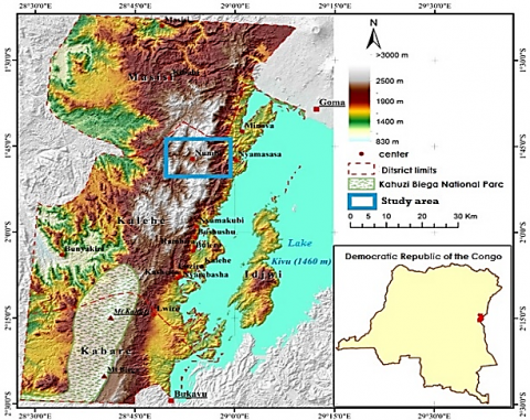
The Numbi region is located in the province of South Kivu in Eastern Democratic Republic of Congo. It falls between 1°45’ of south latitude and 28°45’ and 29 meridian lines of longitude (Figure 1). From Bukavu or Goma, the study area is not easily accessible due to road practicability. A good part of the route to the fieldwork is done by motorbike and foot. Sampling points were accessed through minor roads and footpaths.
Figure 1. Location of the study area
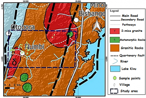
Kivu region is found in the Kibara belt. The rocks of the Kibara Orogeny underpin eastern DR Congo. The Central African Mesoproterozoic Kibaran orogeny extends from Katanga in the south to southern Uganda in the north. This orogenic belt forms a large metallogenic province that contains numerous granite-related ore deposits, which are rich in minerals such as cassiterite, columbite-tantalite (also called coltan), wolframite, beryl, spodumene, amblygonite, monazite, gold, etc. [1, 5, 10]. The Kibara orogeny developed between two pre-Mesoproterozoic domains: the Archaean-Paleoproterozoic Congo craton to the west and north, and the Archaean- and Paleoproterozoic Tanzania craton and Bangweulu Block to the east and south [11]. The Kibara belt consists of two distinct segments, separated in the Kivu area of the DRC by the northwestern extension of the Paleoproterozoic Ubende belt (SW Tanzania) across Lake Tanganyika, the “Northern” (Rwanda, Burundi, Maniema and Kivu in the DRC) and “Southern” (Katanga in the DRC) segments should be viewed as two separate – albeit coeval – orogenic belts [12, 13]. In general, the Kivu basement (eastern DRC) can be subdivided into: An ancient Ruzizian range (2500 to 2000 Ma), mainly outcropping to the west and southwest of Lake Kivu. The folds are oriented NW-SE [14-16]. In terms of metamorphism, the ruzizian chain is characterized by amphibolite-facies rocks (micaschists, gneisses, amphibolites) and migmatites and extends to Rwanda and Burundi, where it is called the Karagwe Ankole belt [5]. The Burundian chain (2000-1500 Ma) is discordant on the Rwandan end and forms the bulk of the lands of Rwanda and Burundi, but is also well represented in central and northern Kivu [14, 15]. The grounds are covered with a thick mantle of metamorphic basalts. To the east, the folded Burundian beds are more or less metamorphic, while towards the west, the folds fade and the layers are almost horizontal and not metamorphic [17]. The geology of this part of the rift consists of three structural assemblages consisting of a Precambrian basement, a volcanic cover to the south and north of Lake Kivu and finally limestone lacustrine deposits that line the bottom of the main valleys at the edge of the lake. The Kalehe formations are anterior to Precambrian and associated with the Itombwe supergroup in East Kivu [18]. Rocks outcropping along Lake Kivu between Katana and Kalehe consist mainly of graphitic black shales, banded red shales, quartzites, ferruginous lamina sandstone, and conglomeratic sandstones with generally weak metamorphism and directed N to NE structural directions; corresponding to two superposed tectonics, the latter giving N-S folds, they are unconformably overlain by the characteristic mixture of the Tshibangu group [19] and intruded by the Nyamukubi granites (whose probable age of intrusion is the same as the other "tin granites" of the region, i.e., 976 ± 10 ma, but whose isotopic equilibrium has been disturbed by more recent events [20]. The Bitale group (lower Kibarian), of which Kalehe belongs, includes all previously considered Ruzizian (2000-1800 Ma) or Archaean terrains [21], and Bitale formations, Bugarama, quartzites and the Kamanyola-Uvira migmatites, the lower Masisi-Sake series, the Luhule-Mobisio formations, and the Kasika-Luntukulu formations [22]. According to the recent Kivu geological map, Numbi is found in the Alkaline Complex, which is rich in Mesoproterozoic rocks, particularly post-orogenic two-mica leucogranites containing niobium and tantalum [9]. These leucogranites are characterized by the presence of biotite and muscovite and are also mapped as two-mica granites (Figure 2).
Figure 2. The modified geology map of Kivu showing the sample points within the study area
During field work, the mapping along profiles from one outcrop to another was completed. At each location, fresh rock units were sampled and labeled for easy identification, as well as geographic coordinates. Each rock sample from a hand specimen was macroscopically described, and rocks were given field names. The map to show the field occurrence lithologies has been made using ArcGIS software. After the field description and mapping, 9 samples were selected for laboratory analysis. Petrographical studies were carried out; The rock samples were chopped into chips with a micro-cutting machine and then polished with carborundum on a glass ground plate to achieve the appropriate thickness and a completely smooth surface at the thin section at the department of geology, University of Burundi (Bujumbura, Burundi). The petrological microscope was used to analyze the produced slides in order to detect mineralogical characteristics of the rock samples at the department of geology of the University of Ibadan, Ibadan, Nigeria. Crystal shape, habit, cleavage, hardness, lustre, color, streak, specific gravity (density), pleochroism, extinction (angle), birefringence, interference color, and twinning are the most common physical and visual qualities used to identify minerals. Optical observations were realized in both plane-polarized and crossed-polarized light. The mineral contents (%) were obtained using point counting through Mesurim software that helps to calculate the surface of an object on an image.
To complete the petrographical studies, 7 Fresh samples were crushed and packed for analysis of major elements composition determination at ACME Analytical Laboratories Ltd, Canada using inductively-coupled plasma atomic emission spectrophotometry (ICP-AES, Spectro Varian735). The powdered pellets were created from 3-5 g of the samples and digested with a mixture of 0.2 g aliquot and 1.5 g LiBO2/LiB4O7 flux in a graphite crucible. The crucibles were heated at 980℃ for 30 minutes in an oven. The bead formed was cooled and dissolved in 5% HNO3 (ACS grade nitric acid diluted in demineralized water). Calibration standards and blank solutions were employed in the analysis procedure to establish the precision and accuracy, both of which were less than 5%. The major elements including SiO2, Al2O3, Fe2O3(t), MnO, CaO, Na2O, K2O, TiO2, and P2O5 were then determined. Chemical classification diagrams were made using Geochemical Data Tool kits (GcDKit 6.0).
5.1 Lithology and field relationship
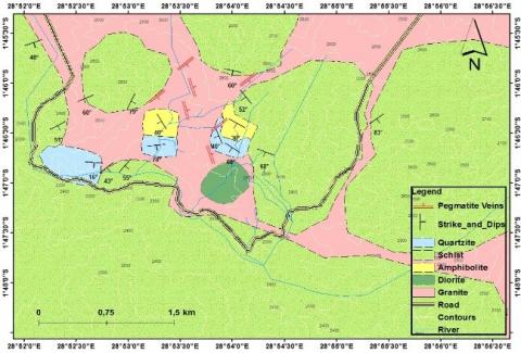
Schist and granite dominate the region, with minor rock types such as diorite, quartzite, and amphibolite also present, with pegmatite defining veins to a lesser extent (Figure 3). The outcrops are well observed on hillsides, in mining quarries (pits), and along road cuts. Schists are predominant of all the lithologies within the study area. Amphibolite is mostly found in the northeast of the study area surmounted with a direct contact by quartzite, found in small amounts as amphibolite. Diorite outcrops in the southeast and Middle of the zone, mostly isolated and sometimes in contact with granite along the hillsides. Granite and schists are found in all parts of the zone and pegmatite in contact with graphitic schist is mostly found in the northern and metamorphic rocks are predominant in the south part and composed of schist, quartzite and amphibolite. Most of the outcrops occur in form of dome with associated screes while others occur as elongated and massive rock units.
As a result, the mapped region (Figure 3), a metamorphic terrain with defined and unambiguous orientation, is made up of two primary rock types with somewhat different features. They consist mostly of schist and granite, with minor rock occurrences of amphibolite, diorite, pegmatitic intrusions, and quartzo-feldspathic veins. Amphibolite and quartzite have joints, whereas gneiss rocks have mineral lineation and foliation. Feldspar, quartz, and muscovite are among the megascopic minerals found in pegmatite and granite.
Figure 3. The Numbi area's geological map
5.2 Petrography
5.2.1 Amphibolite
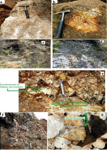
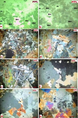
Amphibolites are crosscut by quartz veins (Figure 4b, d). The rock is mostly massive and mesocratic, fine-grained and rich in opaque minerals and plagioclase; some outcrops exhibit weakly to strong foliation (amphibolitic gneiss) with a schistosity underlined by the preferential orientation of elongated dark minerals. The common mineral assemblage (Table 1) includes amphibole, plagioclase, micas, quartz, with opaque minerals as accessories; the latter could sometimes reach 5%. Plagioclase 10 to 20% constitutes euhedral or polygonal grains not exceeding 0.25 mm that are usually associated with euhedral quartz. The whitish colour represents quartz with an irregular shape, lower quantity of biotite form elongated flakes, with orange colour and clustered in the blade while amphibole is the green hornblende abundant and represents about 40-60 vol.% of the rock. Crystals are prismatic with regular borders usually well-joined; the average size is 0.2 to 1 mm (Figure 6a, b). They have been associated with mica (Biotite) (Figure 6c) flakes and well-marked in relief with green. Opaque minerals are dark, anhedral and scattered in the range of the blade approximately 3-4 vol% of the rock.
5.2.2 Schist
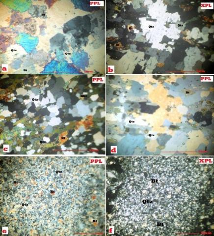
The exposed outcrops have a greyish color and are located in the western section of the research area, with small fractures, altered and rich in iron oxide (Figure 4 e, f, g). The fresh rock of schist analyzed present the mineral paragenesis composed by the oxides weakly represented in blackish colour covering less than 1/5 of the rock; quartz 20-40% total volume of the rock and abundant Micas (15-25%) type of Biotite (Black Micas) (Figure 7b, c et d); in irregular forms connected to quartz crystal with irregular form and elongated from 1-3 mm. Feldspar does not occur in abundant quantity 3-5% of the rock total volume and quietly amount of Hornblende 8% vol% of the rock, the green amphibole with irregular form associated with Biotite.
Figure 4. a) foliated amphibolites in contact with quartzite; b) enlargement of the upper part of (a)showing a strong foliation in amphibolites; c) contact with sandstone d) large blocks of massive amphibolite crosscut by a quartz vein. Schist outcrops (e, f, g), (h, i) diorite outcrops
5.2.3 Quartzite
The grain is very fine; the mineralogical composition is made essentially of quartz of inframillimetric size (Figure 5a), there are few micas as well as ferruginous minerals. This lithology presents several networks of irregular fractures in which residual iron oxides are encrusted. The microscopic investigation (Figure 8e, f) shows a granoblastic texture. The rock is started in several successive dark and light beds 0.1 to 1.2 mm thick, elongated with a particular mineralogical composition. The light band shows the presence of quartz (50%) (Table 1), potash feldspar (7%) and, incidentally, muscovite. The dark beds consist of biotite (40%) (Table 1) and an aphanitic pulp of a particular nature appearing in a dark grey and opaque mineral of lenticular to irregular shape is observed in a small amount of 3% vol of the rock.
Table 1. Mineralogical compositions of rocks
|
Minerals (%) |
Granite |
Diorite |
Quartzite |
Schist |
Amphibolite |
|
Quartz |
30 |
20 |
50 |
45 |
15 |
|
Plagioclase |
15 |
55 |
|
|
25 |
|
Al-Feldpar |
25 |
|
7 |
11 |
|
|
Biotite |
10 |
20 |
40 |
25 |
|
|
Muscovite |
17 |
|
|
|
|
|
Hornblende |
|
|
|
15 |
55 |
|
Accessory Mineral |
3 |
5 |
3 |
4 |
5 |
|
Total |
100 |
100 |
100 |
100 |
100 |
Figure 5. Photograph of types of granites (a, b), mylonite (c, d), altered pegmatite (e, f) and transformation of feldspar into kaolinite (f), and tourmaline-associated quartz crystal recovered from pegmatite (g) 5.2.6 Pegmatite
Figure 6. Microphotographs of amphibolite (a, b, c), diorite (d,e), granite (f,h,g)
Figure 7. Microphotographs of granite (a), schist (b, c, d) and quartzite (e, f)
5.2.4 Diorite
Diorite outcrops are exposed as large blocks and massive rock, dark green, very hard (unaltered) (Figure 4h, i), and cross-cut by quartz veins and veinlets. The main outcrop seems to not be in contact with another lithology within the study area but found as a block. Microscopically (Figure 6d, e), the rock is medium to coarse-grained with heterogranular to granular texture; the mineral assemblage is made of (from the most to the less abundant minerals): biotite, amphibole, quartz, plagioclase; accessory minerals are oxides and zircon. Plagioclase about 55 vol.% of the rock (Table 1).
Appears either as automorphic to sub automorphic phenocrysts with biotite and opaque inclusion, or automorphic small crystals often grouped as millimetric clusters. Biotite forms sub-automorphic flakes and long scatted and recovers about 20 vol. % of the rock. Quartz less than 10 vol.% of the rock, is presented as a large rectangular form of approximatively 2 mm connected to Plagioclase. 5.2.5 Granite
These are granular, massive, whitish or pink-coloured rocks. The phenocrysts consist of quartz, feldspar and muscovite. Macroscopically, the rock is rich in mica (Muscovite associated with Biotite) (Figure 5 a and b) and present quite a low amount of alkali feldspar and Quartz. They also contain vugs and box works filled with iron oxide minerals (hematite) with which limonite are associated. The rock has a high content of 10-20 vol. % of the rock of plagioclase and Alkali feldspar 20-30 vol. % and combines with quartz occurs as irregular grains varying from colourless to milky and is the next in abundance, connected whether to alkali feldspar or plagioclase, and green amphibole (Hornblende) low 1-3 vol% of the rock (Figure 6g, h and Figure 7a). Biotite also appears in irregular form in a quite low amount 5-15 vol% while muscovite is well distributed in moderated amount 10-25 vol% of the rock (Figure 7h).
Pegmatite is significantly changed across the study region. The primary outcrops are located in the northern half of the study region as large fractured chunks. Feldspars are transformed into kaolinite and sericite. The high degree of feldspar alteration results in the development of white kaolinite, as seen in Figures 5e, f, while the other yellow and red iron oxides undergo the same change that results in limonite and goethite. Other minerals found in pegmatite include quartz and elongated (5-10 cm) black tourmaline (Figure 5g). The presence of quartz linked with tourmaline is due to the degree of intense metamorphism. Quartz is mined as a valuable mineral from huge pegmatite blocks that include a minor amount of ferromagnesian minerals. The existence of iron oxide is justified by the yellow color of the ferromagnesian minerals. It is also worth noting the presence of mylonites, which are fragments of altered and crushed schist rocks; these mylonites are rich in iron oxide and appear reddish. They cover a substantial portion of the western portion of the research region, which contains the largest outcrops.
5.3 Major elements geochemistry
Seven bulk rock samples were analyzed for major elements; the results are grouped in Table 2. These geochemical data have been used for the classification and ore characterization of the rocks.
Table 2. Major elements composition of the analyzed rocks
|
Samples |
GR1 |
AMPB1 |
AMPB2 |
DRTE1 |
DRTE 2 |
|
SiO2 |
64.7 |
52.43 |
56.9 |
55.07 |
61.8 |
|
Al2O3 |
15.47 |
13.21 |
11.43 |
15.63 |
15.31 |
|
Fe2O3 |
7.18 |
14.93 |
11.62 |
8.95 |
4.27 |
|
MgO |
1.59 |
5.17 |
4.9 |
6.27 |
5.29 |
|
CaO |
4.24 |
7.96 |
8.5 |
7.87 |
7.54 |
|
Na2O |
1.06 |
2.77 |
2.75 |
2.09 |
2.27 |
|
K2O |
0.04 |
0.54 |
0.78 |
1.37 |
1.7 |
|
TiO2 |
0.8 |
1.84 |
1.9 |
0.77 |
0.72 |
5.3.1 Amphibolite
From Table 2, the Amphibolitic samples range from 52.43 wt% - 56.9 wt% SiO2, 11.43 wt% - 13.21 wt% for Fe2O3, Al2O3 content ranging from 15.31 wt% - 15.63 wt% and a quite low K2O content ranging from 0.54 wt% - 0.78 wt% with the mean value of 0.66 wt%. Amphibolitic rocks show a quite high TiO2 content with mean value of 1.87 wt% and ranging from 7.96 wt% - 8.5 wt% with mean value of 8.23 wt% for CaO content and a range from 4.9 wt% - 5.17 wt% for M gO. The results show Na2O content ranging from 2.75 wt% - 2.77 wt% and the average value of (0.24 wt %) for MnO.
5.3.2 Diorite
Diorite contains between 55.07w% and 61.8 wt% of silica, ranging from 4.27 wt% - 8.95 wt% for Fe2O3and high K2O content ranging from 1.37 wt% - 1.7 wt% with a mean value of 1,53 wt%. Diorite rocks show quite TiO2 content with a mean value of 0.74 wt%. The results show Na2O content ranging from 2.09 wt% - 2.27 wt% and CaO content ranging from 7.54 wt% - 7.87 wt% with a mean value of 7.70 wt%. They display a range from 5.29 wt% - 6.27 wt% for MgO and the average value of (0.145 wt %) for MnO.
5.3.3 Schist, quartzite and granite
The results of the analyzed Schist, Quartzite and granite samples are found in Table 2.
Schist, granite and quartzite samples show 71.29 wt%, 64.7 wt%, 73.1 wt% of SiO2 and 16.48 % wt%, 15.47 wt%, 16.45 wt% Al2O3, respectively. Schist, quartzite and granite have 5.4 wt%,3.11 wt%, and 7.18 %wt of Fe2O3. TiO2 content display 0.89wt% in schist, 0.8wt% and 0.7wt% in quartzite.
Schist, quartzite and granite display respectively 0.12 wt%, 4.48 wt%, and 4.24 wt% CaO.
MgO content display values of 2.62 wt%, 1.59 wt% and 3.08 wt % respectively in schist, granite and quartzite. Schist, granite and quartzite samples display also low MnO content with respective values of 0.04wt%, 0.12wt%and 0.16wt%. The results show Na2O content ranging respectively in schist, granite and quartzite from 1.12wt%, 1.06wt% and 1.17wt%. The analyzed rock samples are showing an important concentration of Na2O (Table 2), which gives the sodic characteristic.
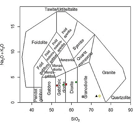
Figure 8. Classification diagram [23]
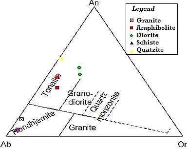
Figure 9. Hyderabad area granitoids on Ab-An-Or normative diagram [24]
Figure 10. Hyderabad area granitoids on Ab-An-Or normative diagram [24]
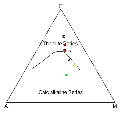
Figure 11. AFM diagram [25]
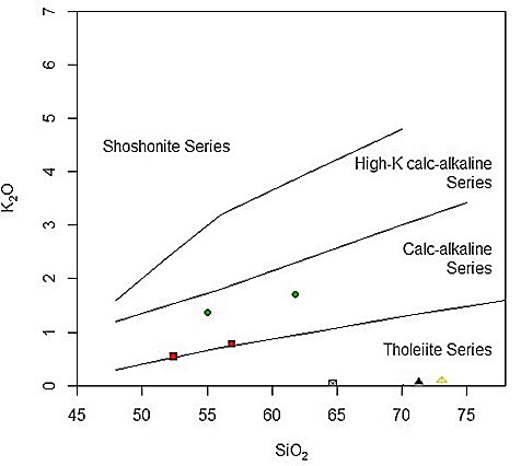
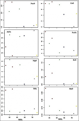
Using the total alkali-silica (TAS) diagram (Figure 8), The analyzed rock samples display dioritic composition which confirms the petrographic studies, they are classified into trondhjemites and in the field of the Tonalite in the normative An-Ab-Or ternary diagram [24] (Figure 9). The majority of the rock samples in the research region are from the tholeiitic series and calc-alkaline series on the AFM diagram (Figure 10), and the K2O-SiO2 (Figure 11). On the Harker's diagrams (Figure 12), close observation shows that the points are not always scattered on all these diagrams: Fe with decrease as long as SiO2 increase, Fe2O3 shows a negative correlation; CaO, MgO and even Na2O show negative correlation (with the possibility of considering two subgroups) whereas K2O and Al2O3 and TiO2 show no correlation. The negative connection between SiO2 and CaO, as well as SiO2 and MgO, indicates plagioclase fractionation and differentiation or fractional crystallization.
Figure 12. The K2O-SiO2 diagram [26]
The preliminary geochemical studies in the mining area of Numbi [7, 27] have shown that The Numbi zone's pegmatite and rare metal granite are moderately rich in Sn, Ta, and Nb of commercial importance, with varying concentrations Ta (27.50 – 370.90 ppm), Sn (238 – 2451 ppm) and Nb (31.80 – 139.20 ppm). The enrichment trend was on the order of Sn>> Ta > Nb. The rare metals (Sn, Nb, Ta, Be, Li, W …) are used in the high-tech and green industries. The special features of these materials assure their expanding use in electronic, optical, mechanical, aeronautical, nuclear, and other current applications. Tantalum and niobium are widely employed in the process industry, vacuum methods, chemical machinery, surgical instruments, and the automobile sector as metals and alloys. The present geological mapping enhanced also that the pegmatite and granite within the Numbi area contain quartz and feldspar. Firstly tantalum, nobium and rare earth elements are sourced from pegmatites. Large amounts of quartz sand also known as silica sand are used in the manufacture of glass and ceramics and for fondry molds in metal casting. Feldspar is a common raw material used in glassmaking, ceramics (pottery, sanitary ware, tableware,..) and to some extent as a filler and extender in pain, plastics and rubber [28]. Weathering or alteration of feldspar results in the development of clay minerals such as kaolinite. Kaolinite is widely utilized for different industrial mineral uses in the painting industry, pharmaceutical industry, and textile industry, while silica sand and gravels are used for various building and construction reasons.
Geological mapping of the Numbi area was carried out and six lithologies have been identified. These include quartzite, amphibolite, schist, diorite, granite and pegmatite. Diorite, amphibolite, quartzite, and schist were not previously documented in the area, and they were accidentally deleted on the most current Kivu map. The mineralogical assemblages of these rocks are formed of quartz, micas (biotite and muscovite), hornblende, feldspars (plagioclase), and others (opaque minerals (iron oxide) and the accessories, according to an optical investigation of thin sections made from rock samples. The petrographical studies have been confirmed and completed by the TAS classification diagram of rocks through analyzed major elements. Generally, the rocks are sharing the fields of intermediate and acidic rocks with silica content varying between 52.43 – 73.1wt%. Metamorphism may be seen in the minerals that make up the rocks. The presence of small-scale artisanal mining activities in the Numbi area confirm that the potential economic interest is found in pegmatites, which are relatively enriched in Sn, Ta and Nb. This hypothesis is also confirmed by new studies implemented in the Numbi area.
Special thanks to African Union through the Pan African University Scholarship for sponsoring this research work. This paper is part of the first author’s M.Sc. thesis at the Pan African University Institute of Life and Earth Sciences, University of Ibadan, Ibadan, Nigeria.
[1] Dewaele, S., Hulsbosch, N., Cryns, Y., Boyce, A., Burgess, R., Muchez, P. (2016). Geological setting and timing of the world-class Sn, Nb–Ta and Li mineralization of Manono-Kitotolo (Katanga, Democratic Republic of Congo). Ore Geology Reviews, 72: 373-390. https://doi.org/10.1016/j.oregeorev.2015.07.004
[2] Melcher, F., Graupner, T., Oberthür, T., Schütte, P. (2017). Tantalum-(niobium-tin) mineralisation in pegmatites and rare-metal granites of Africa. South African Journal of Geology 2017, 120(1): 77-100. https://doi.org/10.25131/gssajg.120.1.77
[3] Dewaele, S., Muchez, P., Burgess, R., Boyce, A. (2015). Geological setting and timing of the cassiterite vein type mineralization of the Kalima area (Maniema, Democratic Republic of Congo). Journal of African Earth Sciences, 112: 199-212. https://doi.org/10.1016/j.jafrearsci.2015.09.006
[4] Melcher, F., Graupner, T., Gäbler, H.E., et al. (2015). Tantalum–(niobium–tin) mineralisation in African pegmatites and rare metal granites: constraints from Ta–Nb oxide mineralogy, geochemistry and U–Pb geochronology. Ore Geology Reviews, 64: 667-719. https://doi.org/10.1016/j.oregeorev.2013.09.003
[5] Dewaele, S., Henjes-Kunst, F., Melcher, F., et al. (2011). Late Neoproterozoic overprinting of the cassiterite and columbite-tantalite bearing pegmatites of the Gatumba area, Rwanda (Central Africa). Journal of African Earth Sciences, 61(1), 10-26. https://doi.org/10.1016/j.jafrearsci.2011.04.004
[6] Dill, H.G. (2015). Pegmatites and aplites: Their genetic and applied ore geology. Ore Geology Reviews, 69: 417-561. https://doi.org/10.1016/j.oregeorev.2015.02.022
[7] Oyediran, I.A., Nzolang, C., Mupenge, M.P., Idakwo, S.O. (2020). Structural control and Sn-Ta-Nb mineralization potential of pegmatitic bodies in Numbi, South Kivu Eastern DR Congo. Lithos, 368: 105601. https://doi.org/10.1016/j.lithos.2020.105601
[8] Lepersonne, J. (1974). Carte Géologique du Zaire, Èchelle 1:2,000,000.- République du Zaïre, Commissariat dʻEtat aux Mines, Service Géologique.
[9] Laghmouch, M., Kalikone, C., Ilombe, G., Ganza, G., Delvaux, D., Safari, E., Bachinya, J., Dewaele, S., Wazi, N., Nzolang, C., Fernandez, M., Tack, L., Nimpagaritse, Kervyn, F. (2018). Carte géologique du Sud-Kivu au 1/500 000. Musée Royal de l’Afrique Centrale, Tervuren.
[10] Kokonyangi, J.W., Kampunzu, A.B., Armstrong, R., Yoshida, M., Okudaira, T., Arima, M., Ngulube, D.A. (2006). The Mesoproterozoic Kibaride belt (Katanga, SE DR Congo). Journal of African Earth Sciences, 46(1-2): 1-35. https://doi.org/10.1016/j.jafrearsci.2006.01.017
[11] Tack, L., Wingate, M.T.D., De Waele, B., Meert, J., Belousova, E., Griffin, B., Tahon, A., Fernandez-Alonso, M. (2010). The 1375 Ma “Kibaran event” in Central Africa: Prominent emplacement of bimodal magmatism under extensional regime. Precambrian research, 180(1-2): 63-84. https://doi.org/10.1016/j.precamres.2010.02.022
[12] Tack, L., Fernandez-Alonso, M., Tahon, M., Wingate, M.T.D., Barritt, S. (2002). The ‘northeastern Kibaran belt’(NKB) and its mineralisations reconsidered: New constraints from a revised lithostratigraphy, a GIS-compilation of existing geological maps and a review of recently published as well as unpublished igneous emplacement ages in Burundi. In Abstracts, 11th IAGOD Quadrennial Symposium and Geocongress, Windhoek (Namibia).
[13] Tack, L., Fernandez-Alonso, M., de Waele, B., Tahon, A., Dewaele, S., Baudet, D., Cutten, H. (2006). The northeastern Kibaran belt (NKB): A long-lived intra plate history. Extended Abstract of oral communication submitted to session 1 (“Geodynamics of Africa”) of the 21st Colloquium of African Geology (CAG21) at Maputo (Mozambique), pp. 149-151.
[14] Boutakoff, N. (1939). Géologie des territoires situés à l'ouest et au nord-ouest du fossé tectonique du Kivu (Résultats scientifiques de la Mission géologique du Comité national du Kivu, Mém. Institut Géologique de l'Université.
[15] Villeneuve, M. (1977). Précambrien du Sud-Kivu, Etude pétrographique, stratigraphique et tectonique, Thèse de doctorat, Fac.Sci et techn., Jerome, Marseille, France, 195.
[16] Cahen, L. (1979). Réunion de travail des 1, 2 et 3 septembre 1975 : La géologie des terrains précambriens voisins de la fosse tectonique occidentale, spécialement dans les régions sises de part et d’autre de la partie sud du lac Kivu et du nord du lac Tanganyika au Kivu, au Rwanda et au Burundi. Mus. Roy. Afr. Centr. Tervuren (Belg.), Dépt. Géol. Min., Rapp. Ann 1975, 143-170.
[17] Goffart, G. (1933). Carte géologique du Kivu entre les méridiens 27°40’ latitude sud. ASGB, PRCB, 57: 27-41.
[18] Villeneuve, M. (1980). Les formations précambriennes antérieures ou rattachées au Supergroupe de l'Itombwe au Kivu Oriental et méridional (Zaïre). Bulletin de la Société belge de Géologie, 89(4): 301-308.
[19] Lavreau, J. (1985). Le groupe de la Ruzizi (Ruzizien du Zaïre, Rwanda et Burundi) à la lumière des connaissances actuelles. Mus. roy. Afr. centr., (Tervuren), Dép. Géol. Min., Rapp. ann., 1983-84, 111-119.
[20] Ledent, D. (1979). Données géochronologiques relatives aux granites Kibariens de type A (ou G1) et B (ou G2) du Shaba, du Rwanda, du Burundi et du Sud-ouest de l’Uganda. Mus. Roy. Afr. centr. Tervuren, Dépt. Géol. Min., Rapp. Ann., 1980, 131-145.
[21] Rumvegeri, B.T. (1987). Le Précambrien de l’Ouest du lac Kivu (Zaïre) et sa place dans l’évolution géodynamique de l’Afrique centrale et occidentale. Pétrologie et tectonique. Ph.D. Thesis, Univ. of Lubumbashi, Dept. Geology 314.
[22] Rumvegeri, B.T. (1984). Etudes lithostratigraphiques et structurales du précambrien de la région de Bunyakiri ; Modèle d'évolution géodynamique de la chaîne Kibarienne en Afrique orientale et centrale. Lubumbashi, Katanga, R.D.C.: Labor. Pétrologie, Univ. Lubumbashi, 183.
[23] Middlemost, E.A.K. (1985). Naming materials in the magma/igneous rock system. Earth-Sciences Reviews, 37: 215–224. https://doi.org/10.1016/0012-8252(94)90029-9
[24] O’Connor, J.T. (1965). A classification for quartz-rich igneous rocks based on feldspar ratios. United States Geological Survey Professional Paper 525-B, p. B79-B84.
[25] Irvine, T.N., Baragar, W.R.A. (1971). A guide to the chemical classification of the common volcanic rocks. Canadian Journal of Earth Sciences, 8(5): 523-548.
[26] Peccerillo, A., Taylor, S.R. (1976). Geochemistry of Eocene calc-alkaline volcanic rocks from the Kastamonu area, northern Turkey. Contributions to Mineralogy and Petrology, 58(1): 63-81. https://doi.org/10.1007/BF00384745
[27] Mupenge, M.P. (2019). Geochemical and structural control of Sn-Nb-Ta mineralization from Numbi area, Eastern D.R Congo, M.Sc Thesis dissertation, Department of Geology, Pan African University of Life and Earth Sciences, University of Ibadan, Ibadan, Nigeria.
[28] Apodaca, Lori E. (2008). Feldspar and Nepheline Syenite, USGS, Minerals Yearbook.