Efendhi Prih Raharjo*![]() | Anisa Mahadita Candrarahayu
| Anisa Mahadita Candrarahayu![]() | Shoffi Naufal | I Kadek Surya Putra Adidana
| Shoffi Naufal | I Kadek Surya Putra Adidana![]()
© 2024 The authors. This article is published by IIETA and is licensed under the CC BY 4.0 license (http://creativecommons.org/licenses/by/4.0/).
OPEN ACCESS
In light of the recurring tsunami threats faced by coastal cities, the significance of transportation infrastructure resilience is underscored, particularly in regions such as Padang City, Indonesia, which has previously experienced the devastating impacts of tsunamis, notably the Mentawai event. This study is aimed at developing a robust evacuation planning strategy to mitigate potential loss of life during tsunami occurrences. Through a quantitative analysis utilizing the PTV Visum software, optimal evacuation routes were identified, emphasizing the importance of infrastructure performance in emergency scenarios. The analysis revealed that certain road segments, including Jl. Raya Balai Baru 2, Jl. Mustika Raya, Jl. Rimbo Tarok - Belimbing, Jl. Koto Baru Banuaran, Jl. Thui Raya 2, Jl. Raya Gadut, and Jl. Durian Taruang, achieved a level of service A, indicating very good performance. These routes are essential for an effective evacuation plan, demonstrating superior efficiency and playing a pivotal role in disaster response strategies. The findings advocate for the integration of these optimal routes into urban planning and disaster preparedness initiatives, aiming to enhance the city’s resilience to tsunami threats. Recommendations are extended to the relevant authorities, highlighting the criticality of incorporating advanced transportation planning tools like PTV Visum in the development of evacuation strategies. Such measures are deemed instrumental in minimizing casualties during tsunami events, thereby contributing significantly to the safety and well-being of the populace.
disaster resilience, evacuation route planning, transportation infrastructure, tsunami preparedness
Disasters occur as a result of natural and man-made events affecting the utility and capability of the transportation system, contrary to social needs that require transportation networks to perform well in the worst conditions. A disaster is a serious disruption to a community or society due to an event with a level of hazard that directly interacts with conditions of exposure, vulnerability, and capacity, resulting in losses and impacts on humans, materials, the economy, and the environment [1]. It is an event or fact that has adverse consequences affecting the environment and every citizen on the surface of the earth [2, 3]. Disaster science requires development in line with changes in scope and extent of coverage related to the level of hazard and risk of social disruption and future impacts on society [4]. Disaster research and preventive action can reduce the economic impact of natural disasters [5]. Disaster risk has an increasing trend and continues to change its nature as the formulation of the global landscape continues to evolve along with the emergence of new risks, which are marked by the emergence of cascades and hazards that are interrelated with one another [6].
In an ideal transportation network, losses during disasters should be minimized and the network should recover quickly to provide an acceptable level of service to the people. In a disaster, transportation infrastructure plays an important role in emergency management. However, transportation infrastructure is also vulnerable to the impact of disasters. Vulnerability is expressed qualitatively or quantitatively in stages where an entity, asset, system, network, or geographic area is vulnerable to loss when experiencing a disaster. One way to describe vulnerability is through resilience. Resilience is part of the ability to quickly recover from various disturbances in unexpected and disasterous conditions [7]. Resilience is an important part of the indicators that describe the performance of the system under unusual conditions, the speed of recovery, and the amount of outside assistance needed to return the system to normal conditions [8]. It also describes the ability to recover more quickly from a disturbance so that operations take place the same as before the disturbance occurred [3]. To increase the resilience of transportation, the concept of resilience needs to be quantified so that it can be measured and assessed. An assessment of resilience can be used to prioritize possible preparedness and recovery efforts. To evaluate the concept of disaster resilience, it is necessary to define disaster and its consequences. According to the Center for Research on the Epidemiology of Disaster (CRED), a disaster is a form of situation or event that exceeds one's capacity and requires the assistance of other parties on a national or international scale, with criteria covering ten people or more who were reported dead, a hundred people or more who were reported as affected, and emergency information from the government, requiring the involvement of international assistance. In every disaster, transportation plays an important role in the process of preparing for, coping with, and recovering from a disaster.
Geologists state that Padang City is one of the cities that has a large potential for a tsunami and has a high risk because many residents are active in coastal areas [9]. Padang City is located on the island of Sumatra, where the subduction zone in the Sumatra region has produced tsunamigenic earthquakes, including the Mentawai tsunami in 2010, the Bengkulu tsunami in 2007, the Nias tsunami in 2005 and the Indian Ocean tsunami in 2004 [10]. The area close to Padang City has a subduction route that can trigger a strong earthquake and can even trigger a large tsunami because it faces the Indian Ocean, so this coastal city must be prepared to face the risks that may occur [11]. Therefore, according to the 2010-2030 Padang City spatial plan, it is necessary to plan a disaster evacuation network system in the form of evacuation routes and evacuation sites on a city, regional and environmental scale. In its implementation, it is necessary to carry out special studies related to the planning of disaster evacuation network systems, including those carried out through studies with the concept of resilience, which focuses on the scope of transportation. The determination of the study includes the level of accessibility of evacuation routes, logistics distribution channels, and determining the location of shelters appropriately to assist the community and government in evacuating due to the tsunami disaster through effective disaster mitigation. The selection of the evacuation route is closely related to the relative spatial syntax steps, which show that the majority prefer to walk in a straight line to reach the assembly point [12]. Logistics distribution acts as a link that connects producers and consumers, who have an important role in the supply chain ecosystem [13]. Shelter locations are often difficult to access, and access is even cut off during the impact of the disaster on the route being traversed [14]. Disaster mitigation needs to actively involve community participation and encourage understanding regarding disaster risk management [15].
In contrast to existing studies on enhancing tsunami resilience in transportation infrastructure, this study uniquely employs PTV Visum to determine evacuation routes. This innovative approach goes beyond traditional methods, providing a more dynamic and precise analysis for transport resilience planning. By integrating advanced simulation tools, this study aims to develop a comprehensive framework that not only identifies optimal evacuation routes but also assesses the overall resilience of the transportation system in Padang City, Indonesia. This novel methodology contributes significantly to the field by offering a more advanced and tailored approach to enhance tsunami resilience in urban transportation networks.
The study was carried out with the aim of conducting an analysis of transportation resilience planning in the disaster mitigation process in order to support people's movement patterns in order to reduce losses and prioritize safety. Some of the steps implemented in supporting the disaster mitigation process can be carried out by measuring and optimizing the resilience of transportation by proposing the creation of optimization models, conducting critical reviews and measurements of the concept of transportation resilience, identifying the dimensions and characteristics of the resilience of road transport networks operationally, and identifying evacuation route plans in the area, which is disaster-prone due to the tsunami.
Urban mitigation policy is a conceptual framework designed to reduce the impact caused by disasters, especially in urban areas. Disaster mitigation includes recognition and adaptation to natural and man-made hazards, as well as ongoing activities to reduce or eliminate long-term risks to human life and property. It is important to promote mitigation policies that require community participation to reduce vulnerability when dealing with disasters [16]. The ultimate goal of developing urban disaster mitigation policies includes efforts to reduce the risks or impacts caused by disasters, especially for urban residents, in the form of fatalities, economic losses, and damage to natural resources; as a guideline for urban development planning; and increasing urban public awareness of reducing disaster risk in order to encourage people to live and work safely.
The primary data collection involves several surveys, including road inventory, traffic counting, and home interviews. A road inventory survey is a detailed process of gathering information about the physical conditions and characteristics of each road segment within a research area, including the length and width of the roads. The purpose of this survey is to acquire an in-depth understanding of the road infrastructure, which is the focus of the study. On the other hand, the traffic counting survey involves collecting data on the volume and types of vehicles passing through a specific point on the road during a specified period. The objective of this survey is to comprehend existing traffic patterns, which are crucial for traffic modeling. Home interviews, or interviews conducted at residences, entail direct interaction with local residents to obtain qualitative information about their travel behavior, transportation preferences, and perceptions of traffic conditions.
The sample for this research was obtained through purposive random sampling from the entire population of Padang City, which is 919,415 people. Sixty percent of this total was selected as the sample, representing the productive population of Padang City and ensuring their involvement in origin-to-destination movements within the city.
The method uses equilibrium loading with Visum software version 10.0. Visum is a program used to make transportation models by analyzing existing traffic conditions and predicting future conditions [17]. To produce a traffic flow model based on the agglomeration of selected areas when creating a sustainable urban traffic system [18], an increase in the flow and speed of vehicles can be predicted by reducing the travel time [19]. Loading is carried out through the stages, which include data collection, coding, structuring, and forming according to a predetermined format. In network development, data regarding zones, nodes, and links is required.
Equilibrium loading in PTV Visum is a loading process within a transportation model that achieves a balance between supply and demand in the modeled transportation network [20]. In the context of Visum, which is transportation modeling software, equilibrium loading aids in creating an accurate representation of traffic distribution in the network, considering factors such as travel time, vehicle types, and movement patterns. This process enables users to understand and predict how traffic can be distributed in a balanced manner within the network under specific conditions.
PTV Visum, being the software utilized for transportation modeling, plays a crucial role in this study. The application allows for the simulation of various transportation scenarios, providing valuable insights into the equilibrium loading process [21]. Additionally, the hypothesis in this research suggests that PTV Visum has the capability to offer effective evacuation routes in the event of a tsunami in the Padang City area. This hypothesis is based on the software's capacity to consider critical factors and contribute to the development of well-structured evacuation plans, ensuring the safety and efficiency of evacuation procedures during a tsunami threat.
The study framework is explained in the form of a flowchart (Figure 1), starting from the initial formulation of the problem to conclusions and suggestions:
Figure 1. Flowchart of the study
3.1 Description of the study area
Padang City is geographically located at 100º 05' - 100º 34' East Longitude and 0º 44' - 01º 08' South Latitude, with an area of 694.96 km² or equivalent to 1.65% from outside West Sumatra Province. Of the total area of Padang City, more than 60% is hilly, covered by protected forests, while the rest is effectively urban. While the topography of the city varies, 49.48% of the land area of Padang City is on a slope of more than 40%, and 23.57% is on a gentle slope. Figure 2 shows the administrative map of Padang City.
Figure 2. Administrative map of Padang City
In 2018, the population of Padang City reached 939,112 people, and the population density increased from 1,334 people/km2 to 1,351 people/km2. The sub-district with the largest population is Koto Tangah, with 193,427 people, but the population density is low, at 833 people/km2. The sub-district with the relatively lowest population of 24,174 people and, at the same time, the lowest density of 250 people/km2 is Bungus Teluk Kabung. Other sub-districts which are also relatively small in population are Pauh sub-district with a population of 504 people/km2 and Lubuk Kilangan with a population of 654 people/km2. The population and area are described in Table 1.
Table 1. Population and area of Padang City
|
No |
Sub-District |
Population (%) |
Area (km²) |
Population Density (people/km2) |
|
1 |
Bungus Teluk Kabung |
2.68 |
100.78 |
249.79 |
|
2 |
Lubuk Kilangan |
5.99 |
85.99 |
653.73 |
|
3 |
Lubuk Begalung |
13.12 |
30.91 |
3984.70 |
|
4 |
Padang Selatan |
6.38 |
10.03 |
5978.27 |
|
5 |
Padang Timur |
8.48 |
8.15 |
9768.10 |
|
6 |
Padang Barat |
4.90 |
7.00 |
6579.29 |
|
7 |
Padang Utara |
7.56 |
8.08 |
8781.06 |
|
8 |
Nanggalo |
6.56 |
8.07 |
7628.13 |
|
9 |
Kuranji |
15.90 |
57.41 |
2600.71 |
|
10 |
Pauh |
7.85 |
146.29 |
503.70 |
|
11 |
Koto Tangah |
20.60 |
232.25 |
832.59 |
|
Total |
100.00 |
649.96 |
1351.32 |
|
3.2 Potential disaster in the Padang City
The city of Padang has a very complex geological structure due to its location in the collision area of two large tectonic plates, namely the Indo-Australian plate in the south and the Eurasian plate in the north, which is marked by the presence of tectonic earthquake centers in the Mentawai Islands and its surroundings. The result of the collision of two large plates then causes other tectonic phenomena in the form of a magmatic arc, which is marked by the appearance of the Bukit Barisan Mountain range and its volcanoes, and the large Sumatran fault, which extends in the direction of the collision zone of the two North-South plates.
The negative impact of the Padang City area is the potential of natural disasters in the form of tectonic earthquakes. Earthquakes centered on land on the Sumatran fault line, or the Semangko Fault, or those centered in the sea on the western coast of Sumatra, are sometimes followed by rising sea levels, better known as tsunamis, in addition to the dangers of volcanic eruptions and landslides. After the Aceh earthquake occurred at the end of 2004, which was followed by a tsunami, the threat of an earthquake and tsunami disaster became a major concern. The series of earthquakes that occurred included M8.5 SR on Nias in March 2005, M6.9 SR around the Mentawai Sea in April 2005, M6.3 SR around Lake Singkarak in March 2007, M8.4 SR and M7.9 SR around the waters of Bengkulu and West Sumatra on September 12 and 13, 2007; and finally, the earthquake on September 30, 2009, with a M7.6 SR that occurred off the coast of Sumatra and is about 50 km northwest of the city of Padang, has traumatized the people of West Sumatra. Even more so with the predictions of seismologists that the next giant earthquake will occur around Mentawai. Figure 3 shows the potential disaster area.
Figure 3. Potential disaster area
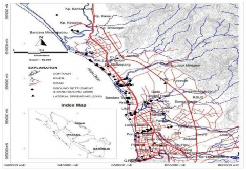
Padang City is one of the coastal city areas that is vulnerable to the danger of major earthquakes originating from the Sumatran subduction zone. One of the earthquake events that occurred in 2009 (Mw 7.6) caused mild to severe damage to buildings and road infrastructure in the city of Padang. In addition to the strong vibrations, liquefaction phenomena also occurred in several coastal and riverside areas in the sub-districts of Koto Tangah, North Padang, South Padang, and West Padang.
Liquefaction events cause the foundations of houses and tall buildings to decrease, cracks in roads and river embankments as well as lateral displacements and landslides [22]. The results of research by Tohari et al. (2011) show that this liquefaction phenomenon occurs due to the presence of layers of water-saturated sand with varying densities from loose to medium at a depth of 10 m.
3.3 Disaster management
The development and improvement of facilities and infrastructure in the transportation sector continue to be carried out by the central government and regional governments. Padang City Road conditions in 2022 has not experienced significant changes when compared to the previous year. According to the type of surface, 38.21 percent, or 801.3 km, of roads are paved, and the remaining 61.79 percent of roads are not paved. When viewed according to conditions, roads in good condition amounted to 66.01 percent, or 1384.11 km. The length of the roads is approximately 2096.86 km, consisting of 91.93 km of primary arterial roads, 117.73 km of secondary arterial roads, 203.06 km of secondary collector roads, 402.51 km of secondary local roads, and 1281.63 km of environmental roads. The characteristics of the road are dominated by the 2/2 undivided type road, with the type of intersection of traffic light signal devices, no signal, and no priority. Judging from its characteristics, this city has a mix of grid and radial road network patterns. High levels of mobility cause the need for transportation services to increase, as can be seen from the increasing number of motorized vehicle owners. The number of motor vehicles by type decreased from 398,401 units to 315,590 units. On the other hand, the number of buses increased by 9.79 percent.
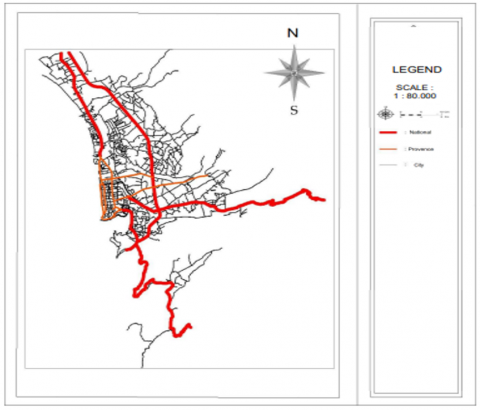
According to data from the Indonesian Ministry of Public Works and Public Housing, the length of the national road in West Sumatra, which includes Padang City, is around 3,603.22 km, while the provincial road in Padang City is around 35.25 km. Padang City has the majority of city roads, which include streets within urban areas. These roads are followed by national roads that are connected to other cities, which are the main routes of inter-city transportation. Meanwhile, provincial roads have the least number because they only connect Padang City with the surrounding districts or cities. Nonetheless, all existing roads are very important to facilitate population mobility and support economic and social development in the Padang City area. It can be seen from Figure 4 that the majority of national roads in Padang City are located on the coast and are very risky in the event of a tsunami disaster. The tsunami disaster can damage and destroy national roads, which makes it difficult for people to move and transport goods.
In addition, the damaged road infrastructure can interfere with access to health facilities, security services, and other essential facilities. A wider impact could occur in the economic and social sectors in Padang City. Interrupted national roads affect logistics and trade flows, which impacts the supply of goods and potentially lead to uncontrollable price increases. If an incident occurs, it can lead to an increase in the cost of living for the community and trigger a shortage of various supplies for the necessities of life. This condition can also create job opportunities and leverage income for residents of Padang City who are affected by a decrease in quality of life and the potential for poverty. From a social perspective, the impact that may occur on national roads can cause difficulties for the public to seek assistance in an emergency. In addition, the cut-off road access can also exacerbate the situation due to a disaster due to delays in providing a response and assistance to victims.
Figure 4. Road network
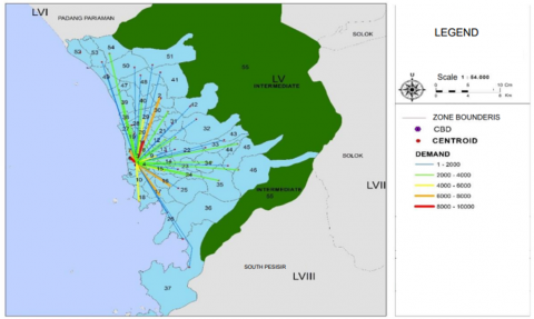
Figure 5. Map of the biggest generating desire line
In simple terms, areas that are classified as tsunami-prone can be seen from Figure 5, where areas in red are areas that are in a less safe zone (below 15m in height). The generation of trips from zone 1 to zones 6 and 11 has the largest number of trips, with an interval of 8000-10000 trips. Trip generation can be caused because zones 6 and 11 are areas that have large economic and industrial activities, marked by the large number of people who work and carry out activities in these regions. In addition, zones 6 and 11 are areas far from zone 1, where there are many options to use private vehicles or public transportation to reach destinations. Meanwhile, zones 1 to 7, 17, 16, and 2 have a trip generation of 6000-8000 trips because they have quite large economic and industrial activities. In addition, zone 2 is a densely populated area and requires effective transportation to facilitate population mobility. Zone 1 is the main location as the central business district in Padang City for economic and business activities and has a dense population, which indicates a high need for population mobility. However, zone 1 has the potential risk of a tsunami disaster, so it requires planning for mobility and transportation in the right area to reduce the risks and impacts that might occur if a tsunami occurs in Padang City.
The map (Figure 6) of the Padang City tsunami-prone zone shows that the color red is the high risk zone, which is an area with a high level of vulnerability to tsunamis; pink is the medium risk zone, which is an area with a medium level of vulnerability to tsunamis; and yellow is the low risk zone (areas with a high level of vulnerability to tsunamis). The risk distribution per sub-district in Padang City based on the potential for a tsunami disaster consists of the high-risk zone covering the districts of West Padang, North Padang, Nanggalo, and parts of Koto Tangah. The medium-risk zone covers the districts of East Padang, South Padang, Kuranji, Bungus Teluk Kabung and the low-risk zone covers the districts of Lubuk Kilangan, Pauh, parts of Koto Tangah.
Figure 6. Tsunami-prone zone in Padang City
Padang City is located on the west coast of Sumatra, which is predicted to be one of the areas that is vulnerable to a tsunami disaster. If a tsunami disaster occurs in Padang City, the sub-districts that are most affected by this disaster will probably include the sub-districts along the west coast of Sumatra. Several sub-districts in the city of Padang which are along the west coast of Sumatra include the sub-districts of West Padang, North Padang, South Padang, Koto Tangah and Lubuk Begalung. These sub-districts have quite dense residential and industrial areas and have various public facilities, including hospitals, schools and offices. Therefore, if a tsunami disaster occurs in Padang City, the sub-districts along the west coast of Sumatra have a high potential to be affected by a quite large disaster. However, the impact that occurs depends on several factors, such as the speed, height, and direction of the tsunami waves and how the risk mitigation has been carried out by the government and the local community. The distribution of risks per zone in Padang City based on the potential for a tsunami disaster is shown in Table 2.
Table 2. Tsunami disaster level per zone
|
Level of Risk |
Zone |
|
High |
1, 3, 5, 6, 7, 8, 11, 19, 20, 27, 28, 29, 30, 38, 39, 40, 47, 48, 49, 50, 52, 53, 54 |
|
Medium |
4, 9, 12, 13, 14, 15, 16, 17, 21, 26, 36 |
|
Low |
2, 10, 18, 22, 23, 31, 37 |
|
Not impacted |
25, 32, 33, 34, 35, 41, 42, 43, 44, 45, 46, 51, 52 |
The level of risk associated with a tsunami is contingent upon various factors, determining whether it is categorized as high, medium, low, or not impacted. High-risk areas are typically characterized by their proximity to tectonic plate boundaries, where seismic activities may trigger tsunamis. Medium-risk areas may have some geological vulnerabilities, while low-risk areas are situated farther from potential tsunami sources. Not-impacted areas, on the other hand, are generally considered safe from significant tsunami threats. Assessing risk involves considering geological, geographical, and historical data to ascertain the potential impact and likelihood of a tsunami occurrence in a given region. Effective risk management and early warning systems are crucial in minimizing the potential consequences of tsunamis in vulnerable areas.
The tsunami-affected area in Padang City in the coastal area includes areas located near the coast or along the coastline. Under normal conditions, the areas potentially affected by the tsunami are centers of economic, trade and business activities in Padang City. However, when a tsunami occurs, these areas can experience very severe damage and can even be fatally destroyed. Several areas affected by the tsunami in Padang City include Buah Market, Air Manis Beach, Padang Beach, and Purus Beach.
To determine the liquefaction points in Padang City, a geological and geotechnical study was carried out to estimate the most vulnerable location to liquefaction. Several factors are taken into consideration in determining the liquefaction point, including soil type, groundwater depth, ground elevation, and the speed and intensity of tsunami waves. From the results of the study, it is possible to determine the points that are most vulnerable to liquefaction and areas that need special attention in disaster risk mitigation planning. This is important to do as part of disaster risk mitigation efforts in Padang City to minimize the impact caused by natural disasters, especially tsunamis. Figure 7 shows the tsunami area with a road network.
Figure 7. Tsunami area with a road network
The liquefaction point is in the tsunami-affected area, and the roads in Padang City have a close relationship in the context of natural disasters. Padang City is located in an area prone to natural disasters such as earthquakes and tsunamis. Liquification points are points, where the ground turns into liquid due to earthquake vibrations, while tsunami-affected areas are areas affected by high sea waves due to earthquakes or other factors. Padang City has several main roads that connect urban areas with other areas. Several roads have an important role because they are the main access for Padang City residents in their daily activities, including during emergencies when natural disasters occur. If an earthquake occurs, which causes a liquefaction point followed by a tsunami, the roads in Padang City, which are in the coastal area, will be largely affected. The liquefaction points that occur can damage the roads in Padang City, so that the road infrastructure becomes difficult to use and difficult to pass. Meanwhile, a wider tsunami-affected area can cut off road access and slow down evacuation and rescue efforts. Therefore, road damage due to natural disasters can be a serious problem for the people of Padang City. In order to minimize the impact of natural disasters on roads in Padang City, risk mitigation efforts, such as good urban planning, the construction of strong road infrastructure, and an effective early warning system for natural disasters are needed. This is expected to help the community and local government deal with natural disasters and minimize the damage caused.
Based on the results of the existing vehicle Origin-Destination (OD) matrix analysis which is entered into the Visum software, the road network performance results are shown in the following Table 3.
Based on the analysis of road network performance results using the Visum application, the road speed is obtained. This traffic flow is included in the service level C with a stable flow category so that the road sections studied can be used for selecting evacuation routes. Based on Table 3, it can be seen that roads at level C or below can be a priority in handling. Even though at level C, traffic conditions are still acceptable with obstacles on the way. However, the vehicle speed is sufficient. In this category, the average speed of the vehicle is around 60-70% of the permitted speed limit. The wait time is less than 35 seconds for vehicles at each intersection. Whereas at level D, the characteristics of traffic conditions are relatively deteriorating, which is indicated by the presence of obstacles and a high enough traffic density which causes vehicle speeds to slow down. The average speed of the vehicle is only about 50-60% of the permitted speed limit. The vehicle waiting time is less than 50 seconds for vehicle travel at each intersection. The level of road service and the selection of the tsunami disaster mitigation route in Padang City have a close relationship and their contribution needs to be considered. The level of road service refers to the road's ability to properly serve vehicles and road users, including in emergency situations such as the result of natural disasters. The choice of a tsunami disaster mitigation route needs to refer to the selection of an evacuation route or a safe route to be followed by the community in an emergency situation.
In the context of mitigating the tsunami disaster in Padang City, the level of service of roads is an important factor in determining the appropriate disaster mitigation route. Roads that have a good level of service can be a choice of safe and effective evacuation routes, while roads that have a poor level of service can complicate or even hinder evacuation and rescue efforts. In addition, the selection of a tsunami disaster mitigation route must also consider other factors such as topography, altitude, and the availability of public facilities around the route. For example, if there are high hills or inclines along an evacuation route, it may be difficult for people in an emergency to pass through that route. Therefore, in selecting a tsunami disaster mitigation route in Padang City, it is necessary to pay attention to the level of service of the road and other factors that can affect the effectiveness and safety of the route. Efforts to repair and increase the level of service of roads must be carried out continuously so that people can more easily and quickly access safe and effective evacuation routes in situations of natural disasters.
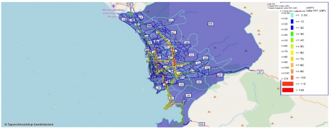
The results of the imposition of the Visum are compared with traffic volume data from survey results in the field, aimed at assessing whether or not the network model that has been made needs to be validated with a statistical test. The statistical test carried out aims to test the resulting modelling results, which are acceptable based on the test criteria that have been set. The total calculated Chi-Square is 0.004, and the table Chi-Square is 30.6123. If it can be concluded that the calculated Chi-Square is smaller than the table Chi-Square, then Ho is accepted and the model can be used as a reference for next year's loading. Figure 8 shows the traffic assignment with PTV Visum. The following is the validation result of the 2022 traffic assignment model.
The output of PTV Visum in the form of color shading ranging from red to green represents varying levels of thickness. The red areas indicate higher levels of thickness, while the green areas represent lower levels of thickness. This color shading is often used to visualize and analyze transportation data such as traffic flow, density, and speed. It can provide valuable insights into areas that may experience congestion or other transportation-related issues. In conclusion, the color shading output of PTV Visum provides a clear and intuitive representation of transportation data, helping planners and analysts make informed decisions for improving transportation infrastructure and optimizing traffic flow.
In the city of Padang, eight road segments have been identified as potential tsunami evacuation routes based on the Volume-to-Capacity (V/C) ratio, where smaller values indicate less congested roads suitable for evacuation. These routes, listed in sequential order of their V/C ratios, are as follows: Jl. Raya Balai Baru 2 (0.134), Jl. Mustika Raya (0.222), Jl. RimboTarok-Belimbing 1 (0.248), Jl. Raya Kampung Tangah (0.339), Jl. Koto Baru Banuaran (0.342), Jl. Thui Raya 2 (0.352), Jl. Raya Gadut (0.355), and Jl. Durian Taruang (0.360). These roads exhibit lower traffic density, making them potentially effective evacuation routes in the event of a tsunami. Mitigating the risk of congestion during evacuation is crucial, and prioritizing these routes based on their V/C ratios contributes to an efficient tsunami evacuation plan for the city of Padang. Table 3 displays information about the performance of the road network.
In an effort to minimize the potential impact of a tsunami disaster in the future, it is necessary to plan disaster mitigation and preparedness programs. Mitigation is an effort to eliminate or reduce the risk of disaster hazards in vulnerable populations. The scope of mitigation includes risk elimination, risk reduction, and responsibility transmission. The focus of mitigation is to eliminate or limit the possibility of a disaster occurring and reduce the level of vulnerability in the population. Preparedness for potential disasters is a form of effort to increase community capacity to respond effectively to the effects of disasters and recover quickly from their long-term impacts. The impact of a traumatic disaster on the population and the environment due to the earthquake and tsunami can be devastating, because it not only results in great loss of life, material and environmental damage, but also drains economic resources that are earmarked for improving people's welfare. Therefore, preventing and minimizing impacts through mitigation and preparedness programs is very important for the survival and welfare of people living in disaster-prone areas such as Padang City. The initial steps taken were to develop effective and efficient alternative approaches to disaster mitigation and preparedness by conducting analyses of disaster mitigation and preparedness policies and surveys of infrastructure assessment and residential facilities, offices, hospitals, public facilities, and the environment, related to the security system and early warning of potential tsunami hazards.
Figure 8. Traffic assignment with PTV Visum
Table 3. Performance of the existing road network
|
No. |
Road Name |
Capacity |
Volume |
VCR |
Speed |
LOS |
|
(km/h) |
||||||
|
1 |
Jl. Andalas |
5479 |
3902 |
0,712 |
47 |
D |
|
2 |
Jl. Perintis Kemerdekaan |
4927 |
3196 |
0,649 |
41 |
C |
|
3 |
Jl. Bgd. Aziz Chan |
5902 |
3982 |
0,675 |
53 |
C |
|
4 |
Jl. Dr Wahidin |
4927 |
2060 |
0,418 |
38 |
B |
|
5 |
Jl. Gajah Mada |
4927 |
2835 |
0,575 |
43 |
C |
|
6 |
Jl. Juanda |
5414 |
3303 |
0,610 |
38 |
C |
|
7 |
Jl. ByPass 3 |
6194 |
2820 |
0,465 |
39 |
C |
|
9 |
Jl. LapauManggis-Belimbing |
1618 |
919 |
0,568 |
32 |
C |
|
10 |
Jl. Parak Karakah |
1532 |
1011 |
0,660 |
22 |
C |
|
11 |
Jl. Parak Laweh |
2020 |
1397 |
0,692 |
41 |
C |
|
12 |
Jl. Parak Pisang |
2397 |
1679 |
0,700 |
55 |
C |
|
13 |
Jl. Jalur Dua Polamas |
6456 |
862 |
0,134 |
45 |
A |
|
14 |
Jl. Raya Gadut |
1583 |
562 |
0,355 |
52 |
B |
|
15 |
Jl. Raya Kampung Jua |
1411 |
497 |
0,352 |
13 |
B |
|
16 |
Jl. Raya Kampung Tangah |
1532 |
380 |
0,248 |
28 |
B |
|
17 |
Jl. RimboTarok-Belimbing 1 |
1342 |
579 |
0,431 |
42 |
B |
|
18 |
Jl. RimboTarok-Belimbing 2 |
1342 |
579 |
0,431 |
42 |
B |
|
19 |
Jl. Thui Raya |
1583 |
579 |
0,366 |
34,27 |
B |
|
20 |
Jl. Utama Pantai Air Manis |
1583 |
731 |
0,462 |
39 |
C |
|
21 |
Jl. Tan Malaka |
1532 |
670 |
0,438 |
37 |
B |
|
22 |
Jl. Abdullah Ahmad |
1532 |
692 |
0,430 |
20 |
B |
|
23 |
Jl. Kapalo Koto |
1532 |
340 |
0,222 |
42 |
B |
|
24 |
Jl. Durian Taruang |
1583 |
1006 |
0,635 |
33 |
C |
|
25 |
Jl. M Yunus |
2277 |
1201 |
0,527 |
40 |
C |
|
26 |
Jl. Indarung |
5956 |
3215 |
0,542 |
55 |
C |
|
27 |
Jl. Sawahan |
5144 |
2722 |
0,529 |
40 |
C |
|
28 |
Jl. Dr Hamka |
6492 |
3834 |
0,587 |
19 |
C |
|
29 |
Jl. Alai Timur |
4927 |
3170 |
0,643 |
51 |
C |
|
30 |
Jl. M Hatta 4 |
5479 |
2753 |
0,503 |
42,43 |
C |
|
31 |
Jl. Kalumbuk-Balaibaru |
1411 |
483 |
0,342 |
35,22 |
B |
|
32 |
Jl. Bypass |
6194 |
2743 |
0,440 |
47,55 |
B |
|
33 |
Jl. Thamrin 3 |
5414 |
3695 |
0,682 |
40 |
C |
|
34 |
Jl. Raya Balai Baru 2 |
1583 |
537 |
0,339 |
29,55 |
B |
|
35 |
Jl. Raya Benteng |
1466 |
914 |
0,635 |
39,93 |
C |
|
36 |
Jl. Raya L Minturun |
1412 |
636 |
0,440 |
38,51 |
B |
|
37 |
Jl. Mustika Raya |
1532 |
844 |
0,565 |
40,33 |
C |
|
38 |
Jl. S Parman |
5956 |
3254 |
0,541 |
42,44 |
C |
|
39 |
Jl. Baru Indarung |
1584 |
324 |
0,360 |
39,37 |
B |
|
40 |
Jl. Khatib Sulaiman 1 |
5956 |
3324 |
0,570 |
42,13 |
C |
|
41 |
Jl. Koto Baru Banuaran |
2020 |
1138 |
0,535 |
39 |
C |
|
42 |
Jl. Teuku Umar 1 |
3772 |
2200 |
0,665 |
33,13 |
C |
|
43 |
Jl. Thui Raya 2 |
1584 |
578 |
0,350 |
34,27 |
B |
|
44 |
Jl. Jembatan Andalas |
5480 |
2215 |
0,840 |
37 |
D |
|
45 |
Jl. Jembatan Seberang Padang |
5414 |
2448 |
0,455 |
38,9 |
C |
|
46 |
Jl. Jembatan UPI |
6492 |
2490 |
0,395 |
43 |
B |
Padang City, located on the west coast of Sumatra, features a network of approximately 3,603.22 km of national roads and 35.25 km of provincial roads. The majority of city roads facilitate urban mobility, making connecting to national roads crucial for inter-city transportation. However, the coastal positioning of many national roads poses a significant risk in the event of a tsunami, potentially disrupting transportation and impacting the movement of people and goods.
The analysis reveals that certain zones in Padang City generate a higher number of trips, particularly zones 6 and 11, characterized by substantial economic and industrial activities. These areas, situated away from Zone 1, show increased trip generation, potentially due to greater employment opportunities. However, the central business district (zone 1) faces the challenge of a tsunami risk, necessitating careful planning to reduce potential impacts on transportation and mobility. Padang City exhibits a varying level of vulnerability to tsunamis, categorized into high, medium, and low-risk zones. Sub-districts along the west coast, including West Padang, North Padang, and Nanggalo, fall under the high-risk category. Buah Market, Air Manis Beach, Padang Beach, and Purus Beach are identified as areas susceptible to severe damage during a tsunami, impacting economic and business centers.
In the context of mitigating the impact of a potential tsunami disaster, the road network's service level plays a pivotal role. Efficient roads with good service levels are crucial for establishing effective evacuation routes. The analysis using the Visum application provides insights into road speed and service levels, aiding in identifying potential evacuation routes. Comparisons with other international studies can further enhance the understanding of effective evacuation strategies and contribute to refining disaster preparedness programs. Prioritizing roads with lower V/C ratios in Padang City, as identified in the study, can be instrumental in devising an efficient tsunami evacuation plan, minimizing congestion risks during emergencies. Eight road segments, ranked by their V/C ratios, offer less congested alternatives for evacuation. Prioritizing roads with lower traffic density, such as Jl. Raya Balai Baru 2 and Jl. Mustika Raya, can contribute to an efficient tsunami evacuation plan. Additionally, ongoing road infrastructure improvements and effective early warning systems are essential for minimizing damage and enhancing community safety.
Based on the data analysis that has been carried out, it can be concluded that in the loading process using the help of the Visum software, it is known that the performance of the Padang City Road network in current conditions and in planned conditions in 2025 has obtained roads that can be used for tsunami disaster evacuation routes because they have good road performance. On the supply side of the road network, there is still a small value of connectivity from a node found in a tsunami-prone area. Based on the analysis carried out on existing shelter services, there are still areas that have not been served and are far from the safe zone boundaries of the tsunami disaster, so after being analyzed and obtaining additional shelters, the area that is not served is getting narrower. The distribution of aid logistics can be solved using the vehicle routing problem based on analysis. To reduce the number of victims when a disaster occurs, there are things that can be done, namely socialization of disaster mitigation in the community in the form of communication, such as sirens and disaster information signs, which are also important.
The identified road segments in Padang, highlighted as potential tsunami evacuation routes based on favorable V/C ratios, present viable options for evacuation. However, their practicality is contingent upon the existence of adequate transportation infrastructure, including signage and road markings, as well as the need for effective public awareness campaigns. Despite possessing low traffic density, these routes can only be successfully implemented with the provision of clear signage and markings to guide evacuees efficiently. Additionally, community outreach and education programs are essential to ensuring that residents are aware of these designated evacuation routes and understand the importance of adhering to evacuation plans. Establishing a well-equipped transportation infrastructure and fostering community awareness are integral components of enhancing the effectiveness of these evacuation routes during a tsunami event in the city of Padang.
This route can be implemented, but there are challenges in its application that involve intensive coordination among stakeholders, detailed evacuation plan development, and public education regarding the evacuation routes. The success of implementing the optimal route also requires the maintenance and development of robust road infrastructure, as well as continuous monitoring to ensure the readiness and accessibility of the evacuation routes during disasters. Additionally, periodic evaluations and dynamic adjustments to environmental conditions and population changes become crucial aspects of maintaining the effectiveness of these evacuation routes in enhancing tsunami resilience in Padang City.
[1] United Nation Office for Disaster Risk Reduction. (2015). Disaster. https://www.undrr.org/terminology/disaster.
[2] Deveci, M., Gokasar, I., Pamucar, D., Alaa, A.A., Wen, X, Gupta, B.B. (2023). Evaluation of cooperative intelligent transportation System scenarios for resilience in transportation using type-2 neutrosophic fuzzy VIKOR. Transportation Research Part A: Policy and Practice, 172(03666): 1-14. https://doi.org/10.1016/j.tra.2023.103666
[3] Kumar, P.G., Tejaswini, V., Rao, P.K., Shankar, G.J. (2021). Disaster mitigation and its strategies in a global context - a state of the art. Materials Today: Proceedings, 45(Part 7): 6488-6492.https://doi.org/10.1016/j.matpr.2020.11.369
[4] Cuthbertson, J., Archer, F., Robertson, A., Rodriguez-Llanes, J. (2023). Societal disruption as a disaster. Exploring suicide, drug addiction and domestic violence in Australia through a disaster risk reduction lens. Progress in Disaster Science, 17: 100271. https://doi.org/10.1016/j.pdisas.2022.100271
[5] Bhola, V., Hertelendy, A., Hart, A., Adnan, S.B., Ciottone, G. (2023). Escalating costs of billion-dollar disasters in the US: Climate change necessitates disaster risk reduction. The Journal of Climate Change and Health, 10: 100201. https://doi.org/10.1016/j.joclim.2022.100201
[6] Shaw, R., Kishore, K. (2023). Disaster risk reduction and G20: A major step forward. Progress in Disaster Science, 17: 100274. https://doi.org/10.1016/j.pdisas.2023.100274
[7] Turnquist, M., Vugrin, E. (2013). Design for resilience in infrastructure distribution networks. Environment Systems & Decisions, 33: 104-120. https://doi.org/10.1007/s10669-012-9428-z
[8] Murray-Tuite, P.M. (2006). A comparison of transportation network resilience under simulated system optimum and user equilibrium conditions. In Proceedings of the 2006 Winter Simulation Conference, Monterey, CA, USA, pp. 1398-1405. https://doi.org/10.1109/WSC.2006.323240
[9] Ashar, F., Amaratunga, D., Haigh, R. (2018). Tsunami evacuation routes using network analysis: A case study in Padang. Procedia Engineering, 212: 109-116. https://doi.org/10.1016/j.proeng.2018.01.015
[10] Mulyani, R., Ahmadi, R., Pilakoutas, K., Hajirasouliha, Taufik, I. (2015). A multi-hazard risk assessment of buildings in Padang city. Procedia Engineering, 125: 1094-1100. https://doi.org/10.1016/j.proeng.2015.11.093
[11] Ashar, F., Amaratunga, D., Haigh, R. (2014). The analysis of Tsunami vertical shelter in Padang City. Procedia Economics and Finance, 18: 916-923. https://doi.org/10.1016/s2212-5671(14)01018-1
[12] Irsyad, H.A.W., Hitoshi, N. (2022). Flood disaster evacuation route choice in Indonesian urban riverbank kampong: Exploring the role of individual characteristics, path risk elements, and path network configuration. International Journal of Disaster Risk Reduction, 81: 103275. https://doi.org/10.1016/j.ijdrr.2022.103275
[13] Zhang, H.F., Ge, H.W., Yang, J.M., Su, S.Z., Tong, Y.B. (2022). Combining affinity propagation with differential evolution for three-echelon logistics distribution optimization. Applied Soft Computing, 131: 109787. https://doi.org/10.1016/j.asoc.2022.109787
[14] Bera, S., Gnyawali, K., Dahal, K., Melo, R., Li-Juan, M., Guru, B., Ramana, G.V. (2023). Assessment of shelter location-allocation for multi-hazard emergency evacuation. International Journal of Disaster Risk Reduction, 84: 103435. https://doi.org/10.1016/j.ijdrr.2022.103435
[15] Mihardja, E.J., Alisjahbana, S., Agustini, P.M., Sari, D.A.P., Pardede, T.S. (2023). Forest wellness tourism destination branding for supporting disaster mitigation: A case of Batur UNESCO Global Geopark, Bali. International Journal of Geoheritage and Parks, 11(1): 169-181. https://doi.org/10.1016/j.ijgeop.2023.01.003
[16] Trejo-Rangel, M.A., Marchezini, V., Rodriguez, D.A., dos Santos, D.M., Gabos, M., de Paula, A.L., Santos, E., do Amaral, F.S. (2023). Incorporating social innovations in the elaboration of disaster risk mitigation policies. Int. International Journal of Disaster Risk Reduction, 84: 103450. http://doi.org/10.2139/ssrn.4073320
[17] Raharjo, E.P., Sarjana, S., Safitri, M. (2022). Transportation infrastructure planning in supporting disaster mitigation: Case study in Mount Gamalama. Jàmbá-Journal of Disaster Risk Studies, 14(1): 1123. https://doi.org/10.4102/jamba.v14i1.1123
[18] Kučera, T., Chocholáč, J. (2021). Design of the city logistics simulation model using PTV VISSIM software. Transportation Research Procedia, 53: 258-265. https://doi.org/10.1016/j.trpro.2021.02.033
[19] Bandi, M.M., George, V. (2020). Microsimulation modelling in VISSIM on short-term and long-term improvements for Mangalore city road network. Transportation Research Procedia, 48: 2725-2743. https://doi.org/10.1016/j.trpro.2020.08.243
[20] Heyken Soares, P., Ahmed, L., Mao, Y., Mumford, C.L. (2021). Public transport network optimisation in PTV Visum using selection hyper-heuristics. Public Transport, 13: 163-196. https://doi.org/10.1007/s12469-020-00249-7
[21] Candrarahayu, A.M. Raharjo, E.P., Rupaka, A.P.G. (2023). Infrastructure management to support logistic distribution and accessibility of deltamas industrial estate. Jurnal Teknologi Transportasi dan Logistik, 4(1): 85-96. https://doi.org/10.52920/jttl.v4i1.140
[22] Tohari, A., Sugianti, K., Soebowo, E. (2011). Liquefaction potential at Padang City: A comparison of predicted and observed liquefactions during the 2009 Padang earthquake. Riset Geologi dan Pertambangan-Geology and Mining Research, 21(1): 7-18.