Deeksha Rai Sharma*![]() | Rohini Ravindrasingh Raghuwanshi
| Rohini Ravindrasingh Raghuwanshi![]() | Tanvi Chandak
| Tanvi Chandak![]() | Dipali Ramdasi
| Dipali Ramdasi![]()
© 2023 IIETA. This article is published by IIETA and is licensed under the CC BY 4.0 license (http://creativecommons.org/licenses/by/4.0/).
OPEN ACCESS
Mountaineering and trekking are outdoor activities that attract thousands of enthusiasts each year. These activities often take place in remote and isolated areas, where medical assistance is scarce, and rescue operations are challenging. When trekkers are injured in such areas, they face significant challenges in accessing help due to the harsh terrain, limited resources, and most notably due to lack of communication infrastructure. In the last century, an average of four people were killed each year on Mount Everest alone, but in the last decade, the number of deaths increased to an average of 6.5 annually. There is a need for an efficient, flexible, and economical solution for safety in mountaineering and other long-distance remote use cases where cellular networks prove ineffective. One of the promising technologies suitable for this application is the LoRa (long range) Network, which is used for communication in isolated areas such as wooded areas (forests) with more minor power consumption. Fast and low-effort localization can potentially increase the chances of saving injured individuals' lives. The proposed system developed a device made of a microcontroller, a GPS module and an accelerometer module to gather trekker data, a LoRa module, and Bluetooth module to transmit data as well as a power supply, and an integrated mobile software application. The system successfully tested the functionality and reliability of an IoT network for tracking and alerting purposes, providing a simple, cost-effective system for safety assistance in case of emergencies. The system showed high accuracy in location tracking, long-range communication capability of up to 1 to 2 kilometers, and reliable performance in various environmental conditions.
mountaineering, safety, Internet of Things, LoRa, accelerometer, microcontroller, GPS, remote areas, emergency assistance
Mountaineering is an adventurous activity that involves climbing mountains or other elevated terrains. The sport is often characterized by high altitude, rugged terrain, and unpredictable weather conditions. As a result, mountaineers are at a higher risk of injuries compared to other outdoor activities. Moreover, mountaineers are typically cut off from civilization and can get separated from their companions, making it difficult to receive timely help when injured.
Mountaineering injuries can be broadly categorized into traumatic injuries and non-traumatic injuries. Traumatic injuries result from falls, rockfalls, avalanches, and other accidents that cause physical trauma to the body. Non-traumatic injuries include altitude sickness, hypothermia, frostbite, and other illnesses related to high altitude and extreme weather conditions.
The remote location of the mountains makes it challenging to access medical help in case of injuries. Mountaineers are typically miles away from the nearest medical facility, and the terrain can make it difficult for rescue teams to reach them. Additionally, unpredictable weather conditions can delay rescue operations, and the lack of communication devices can hinder the transmission of distress signals.
An avalanche hit an Indian military base in the northern Siachen Glacier region on 3rd February 2016, burying 10 soldiers at an altitude of 19,600 ft (5.97 km) under 35 ft (10.67 m) of snow at −45℃ temperature [1]. In May 2017, an Indian mountaineer eventually died after losing contact with the balcony area, the final resting spot before climbers ascend the south summit of Mount Everest [2]. Six soldiers were buried [3] on 20th February 2019 when an avalanche hit the Shipki La pass along the China border in Pooh, Kinnaur in Himachal Pradesh (India). To recover all bodies, the Indian Army launched massive search and rescue operations, which continued for 23 days. In May 2019, two Indian climbers died, and a Chilean was reported missing on Mount Kanchenjunga [4]. Despite rescue attempts, both died above 8000 m due to a lack of oxygen. Several trekkers were stranded [5] in the Chadar trek-Zanskar Valley of Ladakh (India) on 13th January 2020, due to the flow of river water on the ice (Figure 1). The Indian Army and Air Force rescued 41 trekkers. A Border Roads Detachment and labor camp north of Joshimath in Uttarakhand (India) was hit by an avalanche on 23rd April 2021 [6]. The Indian Army rescued 384 persons and recovered 10 bodies. In October 2021, 5 mountaineers of the Navy and 1 porter were reported missing after an avalanche near the peak of Mount Trishul [7]. The Indian army could recover 4 out of 6 bodies. On 4th February 2022, 2 people died on the 120 ft (36.58 m) tall Katarwadi mountain of Nashik district after their rope gave way [8]. A 61-member group was hit by an avalanche early on the morning of October 4, 2022 [9]. While 13 people were missing, 32 people had been rescued, and 16 bodies were recovered from the 5670 m peak of Draupadi Ka Danda. In the last century [10, 11], 305 deaths occurred on Mount Everest alone.
There is a noticeable lack of search and rescue infrastructure in most mountaineering terrains, especially in the Indian Himalayas [12]. Moreover, timely Safety and Rescue (SAR) operations are crucial for minimal loss of life in a mountaineering accident. Several factors can affect the survival of injured mountaineers. The severity of the injury, the availability of medical supplies and equipment, and the time taken to reach medical help are significant factors that determine the outcome.
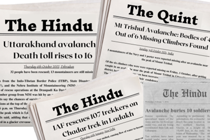
Figure 1. Various newspaper articles headlining casualties and rescue operations in mountaineering accidents
The challenges faced by trekkers in accessing help when they are injured in remote mountaineering terrain are significant. Remote mountainous regions often lack mobile networks, making it difficult for injured trekkers to contact rescue teams or emergency services. Communication in remote areas can be challenging due to the lack of mobile networks and other communication infrastructure. In mountaineering terrain, Cellular, Wi-Fi, and Bluetooth Low Energy (BLE) networks prove ineffective. In such situations, trekkers may have to rely on alternative means of communication, such as satellite phones or emergency beacons, which may not be readily available. Even in areas where mobile networks are available, communication can be unreliable due to factors such as weak signals, network congestion, and weather conditions. This can delay rescue operations and put the safety of the trekkers at risk. Electronic devices such as mobile phones and satellite phones require power to function. In remote areas, where electricity is scarce, trekkers may have limited battery life for their devices, which can hamper communication efforts and delay rescue operations. To address these challenges, there is a need for an efficient, flexible, and economical solution for safety in mountaineering and other long-distance remote use cases.
The rugged terrain, limited infrastructure, severe weather conditions, and communication challenges make it difficult for rescue teams to reach injured trekkers. Hence, there is an urgent need to establish prompt communication not only with the base station but also with fellow peers. This is because companions are often closest and have easier access to an injured trekker.
Wireless Sensor Networks (WSNs) are a network of autonomous and interconnected devices that can be used for monitoring and tracking purposes in remote terrain. WSNs offer real-time monitoring, low power consumption, low maintenance, scalability, and robustness. The use of WSNs in remote terrain can significantly improve the safety and well-being of trekkers by providing real-time data and monitoring capabilities. However, there are also challenges associated with the deployment of WSNs in remote terrain, including the need for reliable communication networks and data management systems. Nonetheless, WSNs remain a promising technology for tracking and monitoring in remote terrain.
Wireless Sensor Networks have gained significant attention in recent years due to their ability to provide real-time data and remote monitoring capabilities. The most common use cases are seen in biomedical [13, 14], environmental [15], vehicle safety [16], military [17], and agricultural [18] fields. WSNs can provide real-time monitoring of environmental conditions, such as temperature, humidity, and air pressure. This information can be used to make informed decisions about the safety and well-being of trekkers in remote terrain. WSNs consume low power, which makes them ideal for use in remote areas where electricity is scarce. The devices can be powered by batteries, solar panels, or other renewable energy sources, which makes them sustainable and cost-effective. WSNs require minimal maintenance, which makes them ideal for use in remote areas where regular maintenance may be difficult or impossible. The devices are designed to operate for extended periods without human intervention, which reduces the need for frequent maintenance visits [19]. WSNs are scalable, which means that they can be easily expanded or modified to meet changing monitoring and tracking requirements [20]. This makes them ideal for use in large-scale projects, such as tracking the movement of trekkers across multiple remote terrain areas. WSNs are robust, which means that they can operate in harsh and unpredictable environments. The devices are designed to withstand extreme temperatures, humidity, and other environmental factors, which makes them ideal for use in remote terrain areas where conditions can be challenging.
A South Korean study [21] successfully developed the Forest-Fire Surveillance System (FFSS) based on WSN. To reduce damages and injuries, the FFSS provides real-time observation by alerting the fire station or neighborhood residents. The biggest challenge with WSN networks is to reduce power consumption for sustainable usage while optimizing the rate of data transmission, instead, an Low Power Wide Area (LPWA) technology-based network is recommended to decrease energy used [22]. A study on Track Bicycle Performance Monitoring using ZigBee [23] reduced power consumption drastically by putting the ZigBee into sleep mode for redundant and converged data, as well as putting the microcontroller in sleep mode when there was no sensor firing.
According to a survey of energy-efficient routing protocols [24], hierarchical protocols are suitable for sensor networks with heavy loads and wide coverage areas. In this class, network nodes are organized in clusters with a cluster head node to reduce energy consumption. On the other hand, the location-based protocols use the position information to transmit the received data to only select regions.
Numerous emerging technologies like the LoRa (Long Range) and LoRaWan (Long Range Wide-area network) have proven fruitful in providing low power long-distance Wireless connectivity [25]. Based on them, various Internet of Things (IoT) services and applications have been developed to reap the many benefits of LPWAN (Low Power Wide Area Network) technology. LoRa network can cover an extensive range in terms of area, depending on the number of obstacles in the environment. This makes it ideal for tracking and monitoring trekkers in remote terrain areas where cellular or other communication networks may not be available. LoRa devices consume low power, making them most appropriate for use in battery-powered devices. The devices can operate on a single battery charge for several days, which makes them ideal for use in remote or hard-to-reach locations where power is scarce. LoRa network is scalable, which means that it can support large-scale deployments of tracking and monitoring devices over a wide area. This makes it idyllic for tracking the movement of trekkers across multiple remote terrain areas. LoRa devices are relatively inexpensive compared to other wireless communication technologies, which makes them affordable for small-scale tracking and monitoring deployments. This makes it accessible to a wide range of users and applications. LoRa network is designed to be resilient, which means that it can operate in harsh and unpredictable environments. The devices are designed to withstand extreme temperatures, humidity, and other environmental factors, which makes them better suited for use in remote terrain areas where conditions can be challenging.
A survey [26] to compare low power wide area (LPWA) IoT technologies found narrowband IoT (NB-IoT) to have a better quality of service, lower latency, more reliability, range, and data rate. However, LoRa performed better in terms of battery life, capacity, and network deployment and outdid in terms of cost and area coverage.
Emphasis has also been made on the estimation of path loss a priori so that an optimum amount of power is transmitted by the radio module [27]. Depending on the severity of the weather, the study concluded linear, exponential, second, and third-order polynomials path loss models.
A tracking and monitoring system based on LoRa for transmission range study [28] found reasonable levels of coverage and link reliability with limited power consumption. In open seas, the transmission range was 4 km, but tall buildings on shore blocked transmission. Data packets were transmitted with end-to-end encryption. Performance and capability analysis conducted by a deployed experiment [29] found a transmission range of 290 m in dense suburban residential areas with a 6V AA battery for over 24 hours.
A search and rescue project [30] to develop localization algorithms and path loss models to estimate the position of injured persons using LoRa modules conducted experiments inside a canyon, and on top of the snow. To simulate avalanche conditions, 1 m deep inside the snow was also considered as a scenario. On average, the transmission range via LoRa was found to be five times that of radio transmission. Body reflections and the water content in snow and snow reflections were significant challenges for transmission.
A study [31] to help farmers easily monitor an automated agricultural system successfully utilized the LoRa protocol for data transmission between two fog layers. A similar study [32] to monitor healthcare in old-age homes uses a LoRa as one of its transmission protocols to send edge-secured data to doctors and nurses as well as between the edge layers. This overcomes the high latency rates in smart systems by using multilayered edge networks.
In a microcontroller-based healthcare monitoring system [33], a LoRa module was used to detect hearing issues, varying pulse rates, headaches with the help of RFID tags and ZigBee. Some studies [34, 35] for developing devices for remote safety used a decentralized as well as bidirectional LoRa-based automatic emergency system to localize victims in remote areas. Activity detection as well as heart rate, temperature, and humidity monitoring were tested and validated with a promising transmission range.
When LoRa signal propagation was tested in different environments such as forests, and urban and suburban areas, a study [36] found that peer-to-peer connection greatly reduces communication range as compared to peer-to-gateway unidirectional communication. Due to lower reflections and fewer obstacles, rural and suburban areas have more stable signal transmission than urban areas. An increase in the speed of device movement over 90 km/hr led to serious link breakages. Speeds less than 40 km/hr proved more stable.
A quadcopter drone equipped with RFID to locate a corresponding RFID tag of the trekker and to collect location data with GPS and transmit it over LoRa has also been successfully tested [37]. The drone was additionally furnished with a microphone and speaker for base station interaction.
Several projects have been developed to create a GPS Tracker using Arduino and LoRa Shield [38] or with Ripple LoRa mesh networks [39]. A project [40] also successfully tested a LoRa-based GPS tracker for an automobile, easily gathering data on whether the vehicle is within the range of the geo-fence tracker.
However, even though LoRa technology is being used in many applications, there is a lack specific research in the field of safety tracking in mountaineering. Commercially available electronic gadgets have been generally well-developed to suit data transmission with cloud IoT services with the help of Wi-Fi. However, this poses a challenge in mountaineering and trekking terrains since such remote areas are not equipped with conventional cellular or internet services. Satellite modems, on which LoRa is based, have good connectivity even in remote locations and can be easily interfaced with the help of microcontrollers. There is a scope to research upon and develop systems overcoming the challenges in rugged terrains with the help of LPWA technology.
3.1 System overview
The proposed system aims to develop a simple, reliable, and low-cost approach to alert peers and operators about injured trekkers quickly and to help them easily track the trekker. In case of a man-down situation, the deployed network of the proposed system facilitates the long-distance communication of the injured trekker with mountaineering companions and the base station, without the need for cellular or Wi-Fi networks.
Figure 2. Basic network architecture
As shown in Figure 2, the network will consist of node devices with each trekker along with a base station. Every device in the network is interconnected to each other via a long-distance network.
Figure 3. An inter-connected network formed by the proposed devices between peers and base camp
As illustrated in Figure 3, an injured trekker (shown in red) is able to communicate their location data to their nearest peers (shown in green) as well as the base camp. Due to the easy tracking of the injured person's position, they will be secured safely and promptly in case of any crisis, as described in the flowchart of Figure 4.
Figure 4. Flowchart illustrating the working of a hardware node
3.2 System details
3.2.1 The hardware node
Each mountaineer is equipped with a hardware device. The device made of a microcontroller, a GPS module, an accelerometer module, a LoRa module, a Bluetooth module, and a power supply, can be carried by each trekker in a group to provide real-time tracking and monitoring, which can significantly improve the safety and well-being of the mountaineers. The device can collect data on the movement of the device and the person carrying it, as well as data in case of sudden motion, and transmit it to other devices using the LoRa module.
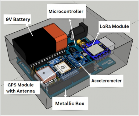
As shown in Figure 5, the device is made of a microcontroller, a GPS module, an accelerometer module, a LoRa module, and a power supply. It can be carried by each trekker in a group to provide real-time tracking and monitoring, which can significantly improve the safety and well-being of the mountaineers.
Figure 5. The architecture of the hardware node
(a) Test device for Node A
(b) Test device for Node B
(c) Connection diagram of testing devices
Figure 6. Hardware devices used for testing
The test system consists of Arduino UNO Rev2 as its microcontroller, NEO-6M GPS modules, ADXL345 and ADXL335 accelerometers, SX1276 LoRa modules, HC-05 Bluetooth module, and a power supply, as shown in Figure 6. The power supply needs of the microcontroller and sensors were sufficed by a 9V AA rechargeable battery during testing. Similarly, 9V Lithium-ion batteries, or solar powered batteries can also be employed. Consequently, despite the obvious downside of being non-rechargeable, the 9V lithium battery is much better regarding performance, longevity, and stability. Up to 50% additional power could be saved without affecting the output power by reducing the supply voltage to the LoRa module to the lowest possible level. In this system, two LoRa boards were used: Adafruit RFM95W LoRa Radio Transceiver Breakout and Dragino LoRa BEE v1.1, both of which use the HopeRF RFM95W module based on the SEMTECH SX1276 LoRa chip. The Adafruit module being cheaper and much more widely available is preferred. Despite being the cheapest of all available options, the module was difficult to integrate with the rest of the device and the WIR-1286 LoRa module could not be successfully tested. The Arduino UNO R3 was used as the microcontroller due to its versatility, ease of use, and low cost. In future iterations of the system, using a microcontroller such as ATMega329P should be sufficient instead of a development board.
The GPS module collects latitude and longitude data, which is used to track the movement of the device and the person carrying it. The accelerometer module captures data in case of sudden motion, such as a fall or injury, which can trigger an emergency response to the other devices in the network. The collected data is stored in the microcontroller and transmitted to other devices in the network using the LoRa module.
The process of sensor data acquisition was initiated with the activation of serial communication, and the baud rate was established. Afterward, the retrieval of location data was initiated by the GPS receiver, which took the form of NMEA sentences and was then separated into its constituent parts: latitude, longitude, and altitude. The same was verified to match the actual location. The x, y, and z directional analog pins of the accelerometer sensor were specified, and the voltage outputs were converted into acceleration measurements, quantified in terms of gravitational force g and then meter per second square. To identify sudden shifts in accelerometer readings and detect a fall or accident, a threshold value was established. Finally, the GPS and accelerometer data were organized into packets and relayed through the LoRa module via the microcontroller.
(a) Side view of first model with dimensions (100mm×85mm×15mm)
(b) Design of armband
(c) Armband device
Figure 7. Armband model of device
The model of the hardware device. The first model of the proposed device is designed to be worn as an armband, as shown in Figure 7. This model is designed to be flatter to ensure obstacle-free arm movement. The second model of the device is designed to be worn as a waist belt, as shown in Figure 8. This model has a more compact design to allow for flexibility of the torso in terms of bending down.
(a) Side view of second model with dimensions (70mm×55mm×35mm)
(b) Top view of second model
(c) Waist belt device
Figure 8. Waist belt model of device
3.2.2 Communication
This transmitted data is then received by the LoRa modules of the peers and base station in the network. Each peer device on the system consists of a similar architecture. Only the physical and datalink layers, as defined in the seven-layer OSI network model, are used in the network of the proposed system. The air is used as a medium for transporting LoRa radio waves from an RF transmitter in an IoT device to an RF receiver. Initially, the single-way transmission was tested between a trekker and a base station by open broadcast on the same frequency. The data was sent from the sensor or device to the base station without receiving any feedback or acknowledgment. This made it suitable for the current scenario where the data transmission was periodic, and the device did not need to receive any commands or feedback from the base station. The base station continuously listened for incoming data packets from the LoRa node on the specified frequency band and channel. When a data packet was transmitted by the LoRa node, the base station received and processed it. Optionally, the data could be processed and analyzed to extract meaningful insights or trigger appropriate actions in future stages. This could include storing the data in a database, sending alerts or notifications, or triggering downstream processes. Subsequently, testing was conducted for two-way communication between two trekker nodes. A one-byte addressing scheme was used, with 0xFF and 0xBB employed as the broadcast and local addresses, respectively. A message was transmitted every 500 milliseconds, and continuous polling was used to detect incoming messages. The chip select, reset, and interrupt pins were defined for this communication system, which was initialized at a frequency of 868MHz using the Serial Peripheral Interface (SPI). The outgoing message packet consisted of recipient and sender identification, message identification, payload length, and the actual payload. On the other hand, each incoming message was examined for its sender identification, message identification, and payload length. After successful verification, the message payload was broadcasted and sent via Bluetooth to be displayed on the mobile device.
A Bluetooth connection was established between the hardware device and the mobile by initializing the Bluetooth module on the microcontroller. The Bluetooth module was configured to communicate with the mobile application using the Bluetooth protocol. The mobile application established a connection via the Bluetooth service UUID (Universally Unique Identifier) provided by the IoT device. Once the Bluetooth connection was established, data could be transferred between the IoT device and the mobile application.
An automatic alert is transmitted in case of suddenly varying accelerometer values. Otherwise, the integrated mobile application can be used to manually trigger an alert to fellow LoRa modules on the network. The collected data can also be used for post-expedition analysis to identify areas of improvement in safety protocols and identify potential hazards.
As per future needs, with increasing trekkers in an expedition, the LoRa network capacity could be expanded using gateways and gateway density. Message collisions could be mitigated by employing adaptive data rate algorithms and optimizing the network setting. Scaling the system to handle more trekkers would result in more devices consuming power. This challenge could be addressed by optimizing device firmware, incorporating low-power modes, and utilizing energy-efficient components.
3.2.3 The software application
A software application will integrate with the hardware device for ease of interaction. The application will help locate peers on a map and well as allow sending manual emergency alerts. The data sent and transmitted by the hardware devices can be easily accessed on the software application.
The software application is developed using the Flutter framework of the Dart language. This makes it ideal for both Android and iOS devices. The mobile device integrates the network of LoRa devices for alerting and tracking purposes. The software application is connected to the hardware device using Bluetooth 4.0 or higher. The application is based on an offline map of the trekking area. Various software development kits, such as the Maps Software Development Kit (SDK), Routes API and the Geocoding API are used to integrate maps into the application. These allow downloading the map of a trek before starting an expedition.
Figure 9. Frontend pages of the software application
The frontend of the software application. The application consists of a menu page, integrating all other pages, as shown in Figure 9. The application has six main components, namely My Profile, Trek Members, Geo Locator, Map, Trek Code, and Device Status. The first component of the application is My Profile, which displays the user's personal information such as name, address, phone number, email ID, and medical history. This component provides the user with easy access to their personal information and ensures that the trek incharge has all the necessary information about the user. The second component is Trek Members, which displays a list of all the members who have joined the selected trek. This component allows users to access the location data of other members within the trek. The third component is the Geo Locator, which displays the live location of all the members of the selected trek. This feature helps users to keep track of their location and the location of other members, which can be crucial in case of emergencies or to avoid getting lost. The fourth component is the Map, which provides an offline map view of the trek to navigate. This feature helps users to navigate the trek with ease, even in areas with poor internet connectivity. The fifth component is Trek Code, which is a unique code assigned to each trek incharge. All members of the trek are supposed to join it using this code, which helps keep track of all the members and aids avid trekkers in keeping track of their different trek groups. This feature simplifies the process of organizing and joining a trek. The final component is Device Status, which displays the live status of the components of the user's location-monitoring device. In case of any damage or error, the user can resolve the issue easily using the solution guides provided with each component. To implement the above components, six classes were created, one for each component. Each class consists of widgets, and each widget consists of a singular scaffold. This design provides a clear and organized interface for the user, allowing them to access all the necessary features with ease.
Since the smartphone the device is only used as display device for ease of access, any inbuilt sensors of the smartphone, such as a gyroscope, GPS, or accelerometer, are not used. The data sent to the smartphone from the IoT device are only stored on the smartphone device and the IoT device temporarily for the duration of the trek. Minimized the collection and retention of sensitive data, reduces the potential impact of a data breach or unauthorized access. The system provides clear information to users about the data being collected, and how it will be used and obtains explicit consent from users before collecting and processing their data.
The proposed system aimed to develop a low-cost, reliable, and efficient approach to track and alert mountaineering peers and operators in case of an injured trekker. The hardware device can collect data on the trekker's movement, and sudden motion, and transmit it to other devices using LoRa modules.
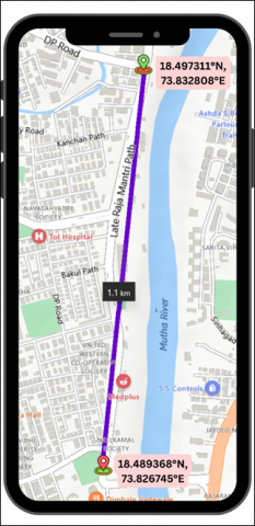
The proposed system was tested on a sunny day with a temperature range of 30℃ to 36℃, with a relative humidity of 33%. As shown in Figure 8, testing occurred in an urban area within line of sight. Latitude and longitude data could be gathered to up to 8 significant digits, ensuring appropriate accuracy of geolocation. Initially, simplex data transmission from the trekker node to the base station was carried out. Here, the trekker node acted as a transmitter-only device and the base station acted as a receptor-only node. Next, simultaneous two-way communication between two trekker nodes was successfully tested. In this case, both the trekker nodes were transmitting and receiving data. As shown in Figure 10, the test system could successfully send data packets using the LoRa module a distance of 1 km to 2 km in an urban area with only 10% data loss, which aligns with the tested capabilities of LoRa modules in similar conditions. The system facilitated long-distance communication between the injured trekker with mountaineering companions and the base station without the need for cellular or Wi-Fi networks. The location data of the trekker, as well as their peers, were reflected on the map, and alerts showed up on the app to respective peers in case of an emergency on the software application.
LoRa communication is optimized for long-range coverage and power efficiency, which can introduce higher latency compared to technologies with faster data rates. While LoRa is designed to have good signal penetration and resilience against interference, it can still be affected by obstacles such as buildings, trees, or other physical obstructions. Dense urban environments or areas with significant radio frequency interference may impact the range and reliability of LoRa tracking devices.
To reduce or avoid data loss when transmitting LoRa data packets, it is important to consider the spreading factor (SF) used in the modulation. LoRa modulation offers six spreading factors, ranging from SF7 to SF12. Packets with the same SF arriving simultaneously on the same channel can result in collisions. If one packet is stronger by six dB, it will have a higher chance of surviving the collision. Choosing a larger spreading factor enables the signal to travel further without errors. The use of orthogonal spreading factors ensures that packets using different SFs do not interfere with each other, appearing as noise. Therefore, selecting an appropriate spreading factor and ensuring sufficient signal strength can help reduce data loss in LoRa transmission. For more effective communication, data can be transmitted cyclically by setting up the devices. This will also act as a power saving technique, along with other software optimizations for the same. Instead of continuous transmission, the transmission will occur in predefined intervals or cycles, typically based on specific timing parameters. The data will be transmitted by only a single node at a time, while the remaining nodes will receive the data. The nodes will transmit in the serial order of their address.
Figure 10. Communication distance testing in urban area
Several existing devices in this field rely on Bluetooth-paired devices that utilize a smartphone to send an SMS, e-mail, or phone call alert to predetermined contacts or emergency services. This system not only relies on the battery of the smartphone, but also the cellular and internet connectivity in the remote area, which can be sketchy at best. Additionally, the faraway phone book contacts of a mountaineer will almost never be first responders, but other trekkers in the area can be. Therefore, in comparison, the proposed system's hardware and software components are low-cost, reliable, and easy to use, making it ideal for use in remote and challenging environments.
Mountaineering is a high-risk activity that can lead to injuries that are difficult to treat due to the remoteness of the location. Injured mountaineers may face challenges in accessing medical help, which can affect their chances of survival. Most lives can be easily saved if timely help is provided. However, lack of communication is a major setback in such situations. Therefore, improving communication and rescue technologies can help reduce the time taken to reach injured mountaineers and improve their chances of survival. Remote regions lack cellular connectivity; therefore, satellite and wireless sensor networks are most suited here.
To address the problem, the proposed system used LoRa-based devices to form a communication network. Here, the LoRa network works without a cellular network or the internet, which is an advantage in mountainous regions that lack access to conventional networks. The devices are also designed to consume extremely low power to facilitate usage in remote areas with limited power access for long periods of time. The system successfully demonstrated simplex data transmission from the trekker node to the base station as well as simultaneous two-way communication between two trekker nodes. By leveraging LoRa modules, the system overcame the limitations of cellular and Wi-Fi networks, ensuring communication coverage in challenging terrains. The ability to transmit and receive data over long distances, coupled with real-time location tracking and emergency alerts, empowers mountaineering companions and operators to swiftly respond to injured trekkers, potentially reducing rescue times and increasing survival rates. Therefore, the system has the potential to save lives and improve overall safety standards in the field of mountaineering.
With growing enthusiasm for mountaineering activities and the evolution of IoT technologies, there are opportunities for the proposed project to expand in various domains. Firstly, the devices can be integrated with healthcare sensors like a photoplethysmography (PPG) sensor to measure heart rate, an accelerometer to detect movement, and a temperature sensor to monitor body temperature. In some cases, additional sensors may be incorporated, such as SpO2 sensors for measuring blood oxygen levels. Advanced software algorithms will process this data to derive meaningful insights and health metrics about a trekker, improving the efficiency of the device. Similarly, long-time data collected from the devices can be used with other systems or technologies, such as cloud services, big data analytics, or artificial intelligence. This will help in taking primitive measures to avoid accident-prone areas. Consequently, the cost of manufacturing, sourcing, and incorporating these specialized sensors, as well as the development of software algorithms for data analysis, will contribute to the overall higher price of the device. Moreover, the battery life of such a device may be shorter, requiring more frequent recharging, compared to a device without such sensors. This negatively impacts the low power aspect of the proposed system. However, advancements in technology and optimization efforts are continually being made to mitigate the impact on battery power usage. Additionally, the device can be made more user-friendly by simplifying the setup process, improving the overall usability of the system, and adding more user-friendly interfaces.
Presently, technical support and consultancy for the implementation of the Proof of Concept (PoC) of the proposed system was provided by the Guardian Giripremi Institute of Mountaineering [41]. Partnering with such institutes will help to gain valuable insights into the challenges faced by mountaineers and their communication needs in remote and rugged environments. They can provide expert guidance on the practical aspects of implementing the proposed system, such as deployment strategies, user requirements, and system performance evaluation. Similarly, there is scope for collaboration with relevant government agencies and non-profit organizations focused on mountaineering safety and communication. Industry partners in IoT and wireless technologies as well as research institutions with expertise in communication systems can provide additional support and guidance.
Improving communication and rescue technologies in mountaineering activities is of crucial importance. The remote and high-risk nature of these expeditions makes it crucial to reduce response time and enhance the chances of survival for injured mountaineers. To fully unlock the potential of IoT-based devices for mountaineering, further research, development, and collaboration in this field is essential. Continued advancements in technology and its applications will undoubtedly lead to even more sophisticated and effective tools that can significantly improve the safety and communication aspects of mountaineering activities. This opportunity must be seized, and efforts must be made together to shape a future where mountaineers can explore with confidence, knowing that reliable and life-saving assistance is always within reach.
This work is supported by MKSSS’s Cummins College of Engineering for Women (Pune) and Guardian Giripremi Institute of Mountaineering.
[1] The Hindu. (2016). Avalanche buries 10 soldiers in Siachen. The Hindu. https://www.thehindu.com/news/national/Avalanche-traps-10-Army-personnel-in-Siachen/article60563433.ece.
[2] PTI. (2017). Missing Indian mountaineer dies after climbing Mount Everest. Hindustan Times. https://www.hindustantimes.com/india-news/chances-of-survival-slim-for-missing-indian-mountaineer-ravi-kumar-official/story-tUU5l1X50WNtQX9iWcQGSP.html.
[3] TNN. (2019). Kinnaur avalanche: Bodies of last 2 missing jawans recovered | Shimla News - Times of India. The Times of India. https://timesofindia.indiatimes.com/city/shimla/kinnaur-avalanche-bodies-of-last-2-missing-jawans-recovered/articleshow/68417345.cms.
[4] AFP. (2019). Two Indian climbers die on Mount Kanchenjunga, world’s third highest mountain. The Hindu. https://www.thehindu.com/news/national/two-indian-climbers-die-on-mount-kanchenjunga-worlds-third-highest-mountain/article27146942.ece.
[5] The Hindu. (2020). IAF rescues 107 trekkers on Chadar trek in Ladakh. The Hindu. https://www.thehindu.com/news/national/iaf-rescues-many-trekkers-on-chadar-trek-in-ladakh/article30576559.ece.
[6] Peri, D. (2021). 384 rescued, 10 bodies recovered in Uttarakhand avalanche. The Hindu. https://www.thehindu.com/news/national/scores-rescued-several-bodies-recovered-in-uttarakhand-avalanche/article34399169.ece.
[7] Quint. (2021). Mt Trishul Avalanche: Bodies of 4 Out of 6 Missing Climbers Found. TheQuint. https://www.thequint.com/news/india/uttarakhand-5-navy-mountaineers-1-porter-missing-after-avalanche-in-mount-trishul.
[8] Naidu, J.S. (2022). Rope gives way, 2 die as they climb down peak on Katarwadi mountain. The Indian Express. https://indianexpress.com/article/cities/mumbai/rope-gives-way-2-die-katarwadi-mountain-7755747/.
[9] Mishra, I. (2022). Uttarakhand avalanche | Death toll rises to 16. The Hindu. https://www.thehindu.com/news/national/uttarakhand-avalanche-five-more-bodies-recovered-from-site-nehru-institute-of-mountaineering/article65975472.ece.
[10] Arnette, A. (2021). Everest by the Numbers: 2022 Edition. The Blog on Alanarnette.com. https://www.alanarnette.com/blog/2021/12/13/everest-by-the-numbers-2022-edition/.
[11] Butcher, B. (2019). How deadly is Mount Everest? BBC News. https://www.bbc.com/news/world-47418215.
[12] Strapazzon, G., Schweizer, J., Chiambretti, I., Brodmann Maeder, M., Brugger, H., Zafren, K. (2021). Effects of climate change on avalanche accidents and survival. Frontiers in Physiology, 12. https://doi.org/10.3389/fphys.2021.639433
[13] Antonopoulos, C.P., Voros, N.S. (2016). Resource efficient data compression algorithms for demanding, WSN based biomedical applications. Journal of Biomedical Informatics, 59: 1-14. https://doi.org/10.1016/j.jbi.2015.10.015
[14] Stuart, E., Moh, M., Moh, T.S. (2008). Privacy and security in biomedical applications of wireless sensor networks. 2008 First International Symposium on Applied Sciences on Biomedical and Communication Technologies, pp. 1-5. https://doi.org/10.1109/ISABEL.2008.4712575
[15] Shakeri, M., Sadeghi-Niaraki, A., Choi, S.M., Islam, S.M.R. (2020). Performance analysis of IoT-based health and environment WSN deployment. Sensors, 20(20): 5923. https://doi.org/10.3390/s20205923
[16] Ramdasi, D., Bhoge, L., Jiby, B., Pembarti, H., Phadatare, S. (2023). IoT-based automotive collision avoidance and safety system for vehicles. In Congress on Intelligent Systems. (pp. 667-681). Singapore: Springer Nature Singapore.
[17] Prabhu, B., Pradeep, M., Gajendran, E. (2016). Military applications of wireless sensor network system. A Multidisciplinary Journal of Scientific Research & Education, 2(12). https://ssrn.com/abstract=2905627
[18] Kassim, M.R.M., Harun, A.N. (2016). Applications of WSN in agricultural environment monitoring systems. 2016 International Conference on Information and Communication Technology Convergence, Jeju, Korea (South), pp. 344-349. http://doi.org/10.1109/ICTC.2016.7763493
[19] Leu, J.S., Chiang, T.H., Yu, M.C., Su, K.W. (2015). Energy efficient clustering scheme for prolonging the lifetime of wireless sensor network with isolated nodes. IEEE Communications Letters, 19(2): 259-262. https://doi.org/10.1109/lcomm.2014.2379715
[20] Cardei, M., MacCallum, D., Cheng, M. X., Min, M., Jia, X., Li, D., Du, D.Z. (2002). Wireless sensor networks with energy efficient organization. Journal of Interconnection Networks, 03(03n04): 213-229. https://doi.org/10.1142/s021926590200063x
[21] Son, B., Her, Y., Kim, J.G. (2005). A design and implementation of forest-fires surveillance system based on wireless sensor networks for South Korea mountains. International Journal of Computer Science and Network Security, 6(9B).
[22] Mohamed, S., Hassan, A.M., Aslan, H.K. (2021). IoT modes of operations with different security key management techniques: A survey. International Journal of Safety and Security Engineering, 11(6): 641-651. https://doi.org/10.18280/ijsse.110604
[23] Gharghan, S., Nordin, R., Ismail, M. (2014). Energy-efficient ZigBee-based wireless sensor network for track bicycle performance monitoring. Sensors, 14(8): 15573-15592. https://doi.org/10.3390/s140815573
[24] Pantazis, N.A., Nikolidakis, S.A., Vergados, D.D. (2013). Energy-efficient routing protocols in wireless sensor networks: A survey. IEEE Communications Surveys Tutorials, 15(2): 551-591. https://doi.org/10.1109/SURV.2012.062612.00084
[25] Garg, R.K., Bhola, J., Soni, S.K. (2021). Healthcare monitoring of mountaineers by low power wireless sensor networks. Informatics in Medicine Unlocked, 27: 100775. https://doi.org/10.1016/j.imu.2021.100775
[26] Sinha, R.S., Wei, Y., Hwang, S. (2017). A survey on LPWA technology: LoRa and NB-IoT. ICT Express, 3(1): 14-21. https://doi.org/10.1016/j.icte.2017.03.004
[27] Garg, R.K., Soni, S.K. (2021). Empirical path loss models at 433 MHz in Himalayan snow for health monitoring. World Journal of Engineering, 19(2): 157-165. https://doi.org/10.1108/wje-03-2021-0134
[28] Sanchez-Iborra, R., Liaño, I. G., Simoes, C., Couñago, E., Skarmeta, A. (2019). Tracking and monitoring system based on LoRa technology for lightweight boats. Electronics, 8(1): 15. https://doi.org/10.3390/electronics8010015
[29] Hashim, N., Idris, F., Tuan Ab Aziz, T.N.A., Johari, S.H., Mohd Nor, R., Ab Wahab, N. (2021). Location tracking using LoRa. International Journal of Electrical and Computer Engineering (IJECE), 11(4): 3123. https://doi.org/10.11591/ijece.v11i4.pp3123-3128
[30] Bianco, G.M., Giuliano, R., Marrocco, G., Mazzenga, F., Mejia-Aguilar, A. (2020). LoRa system for search and rescue: Path loss models and procedures in mountain scenarios. IEEE Internet of Things Journal, 8(3): 1985-1999. https://doi.org/10.1109/jiot.2020.3017044
[31] Raghu, R., Jayaramaan, V., Jayaraman, J., Nukala, S.S.V., Montenegro-Marin, C.E. (2022). A user-centered security approach to create an IoT based multi-layered fog-cloud architecture for data optimization in raised bed farming. International Journal of Safety and Security Engineering, 12(6): 767-776. https://doi.org/10.18280/ijsse.120614
[32] Raghu, R., Jayaraman, V., Jayaraman, J., Nukala, S.S.V., Díaz, V.G. (2022). A multi-layered edge-secured cloud framework for healthcare monitoring in old-age homes using smart systems driven by comprehensive user interaction. International Journal of Safety and Security Engineering, 12(4): 449-457. https://doi.org/10.18280/ijsse.120405
[33] Rahaman, A., Islam, M., Islam, M., Sadi, M., & Nooruddin, S. (2019). Developing IoT based smart health monitoring systems: A review. Revue d’Intelligence Artificielle, 33(6): 435-440. https://doi.org/10.18280/ria.330605
[34] Tayeh, G.B., Azar, J., Makhoul, A., Guyeux, C., Demerjian, J. (2020). A wearable LoRa-based emergency system for remote safety monitoring. 2020 International Wireless Communications and Mobile Computing (IWCMC), Limassol, Cyprus, pp. 120-125. https://doi.org/10.1109/iwcmc48107.2020.9148359
[35] Shobha, H., Bumika, N., Lekhana, B.S., Likhitha, B.S., Nithyashree, N.A. (2020). Real time tracking and security system for rural areas using LoRa network. International Journal of Research in Engineering, Science and Management, 3(5): 418-424.
[36] Ferreira, A.E., Ortiz, F.M., Costa, L.H.M.K., Foubert, B., Amadou, I., Mitton, N. (2020). A study of the LoRa signal propagation in forest, urban, and suburban environments. Annals of Telecommunications, 75(7-8): 333-351. https://doi.org/10.1007/s12243-020-00789-w
[37] Rathinapriya, V., Rahul, D., Rakesh, M., Suganthan, P. (2021). Ensuring the survivability of the trekker using drone and RFID technology. Advances in Parallel Computing Technologies and Applications, 40: 383-390. https://doi.org/10.3233/apc210162
[38] Raj, A. (2019). Lora based GPS tracker using Arduino and LoRa shield. Circuit Digest. https://circuitdigest.com/microcontroller-projects/lora-based-gps-tracker-using-arduino-and-lora-shield.
[39] Powell, S. (2019). LoRa GPS tracker: 6 steps. Instructables. https://www.instructables.com/LoRa-GPS-Tracker/.
[40] Fahad, S. (2022). Arduino LoRa GPS tracker for car, GPS LoRa tracker, geofence tracker, GPS vehicle tracking. Electronic Clinic. https://www.electroniclinic.com/arduino-lora-gps-tracker-for-car-gps-lora-tracker-geofence-tracker-gps-vehicle-tracking/.
[41] GGIM. (2015). Guardian Giripremi Institute of Mountaineering. https://ggim.in/