Wessam Ahmed*![]() | Ahmed Yousry
| Ahmed Yousry![]() | Marwa Sebawy
| Marwa Sebawy![]()
© 2024 The authors. This article is published by IIETA and is licensed under the CC BY 4.0 license (http://creativecommons.org/licenses/by/4.0/).
OPEN ACCESS
Greater Cairo Region has grown into segments through successive cohesions. It has experienced a number of phenomena in its journey of development, such as the increasing trajectory of population declines in the old urban mass, the movement of upper classes to the suburbs, as well as the emergence of the pattern of gated communities. The cause of these phenomena resulted from a group of specific factors; (ageing families and ageing buildings, noise pollution, traffic congestion and bottlenecks, etc.). Political and economic factors were dominant in the emergence of these spatial patterns, in addition to the reduction or marginalization of social, urban and legislative factors. The growth and mobility of the upper classes in the region were consistent with the ring theory of upper-class growth and mobility at the beginning of the century until the early 1970s, and with both sectoral and multiple nuclei theory from the mid-1970s, where economic policies shifted to new economic reform programs, underpinned by correlated dynamic processes.
ecological theories, gated community, Greater Cairo, spatial mobility, upper class, social stratification, urban sociology
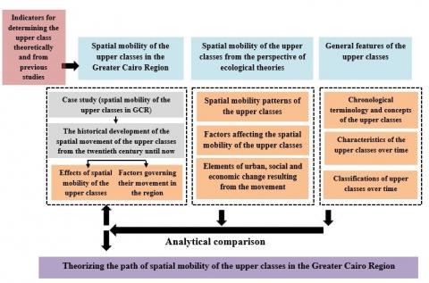
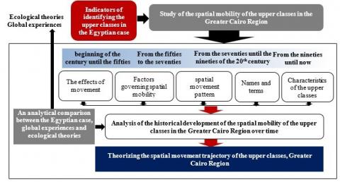
Upper classes are considered one of the most essential components of the city's internal social structure. Spatial alterations have been shown to occur over time as a result of the interaction of a number of political, social, economic, urban, and lastly, legislative aspects that cities witness or experience. These contributing factors may interact with one another over time to produce a certain spatial pattern for these classes, while in others, factors may dominate over other factors throughout the same period. Prior to the Nasser period, environmental and social factors dominated because of ecological processes in city centers, such as the invasion of upper-class sites by lower-class activities causing pollution, noise, and crowding. As a result, the upper classes fled to the suburbs in quest of tranquility, security, and peace. During the Nasser period, most of the factors interacted and led to the displacement of the upper classes towards Heliopolis and Nasr City in the east, Maadi in the south, and the Nile Corniche, Zamalek, and Mohandessin in the west. Among the most important factors are adopting socialism and its subsequent laws and regulations (political factors), high rates of immigration and population (social factors), in addition to economic factors such as the tendency toward industrialization and the establishment of industrial zones to encourage urbanization in Cairo's north and south, as well as the increase in unplanned residential areas to absorb the surplus population (urban factors). From the 1970s until the early 1990s, all causes converged to create a pattern of displacement to the outskirts and suburbs. Among these factors were the state's economic openness policy, followed by structural adjustment policies and economic reform policies, the drive toward globalization, the information and technology revolution, and changes in investment patterns in the public and private sectors. As a result, prices for products and services have risen, and the state has implemented urban development policies through the formation of the General Organization for Physical Planning, which is responsible for developing and updating urban development plans and strategies for the Greater Cairo Region. In addition, the strategic plan for the region was prepared in 1988. The concept was based on encircling the major urban mass with a ring road, establishing new urban communities on neighboring desert areas, and defining the eastern and western urban growth axes. As a result, the main urban mass of Cairo merged with the new urban communities via a collection of new urban extensions, such as (New Heliopolis and El Shorouk in the east) or urban community expansions (Badr, Obour, Sheikh Zayed, New Cairo) (urban factors). These factors resulted in the formation of a pattern of gated communities on the outskirts or in the suburbs of traditionalCairo, with residents seeking protection, safety, quality of life, amenities, and investment opportunities. This pattern has resulted in neighborhoods that are distinct from one another. The urban realm was fragmented, and this fragmentation led to social discrimination as the contrasts between neighborhoods grew more pronounced in terms of affluence, infrastructure, sanitation, services, and so on. It has reached the stage of class discrimination, neighborhood discord, and socioeconomic conflicts, with some portions of the city becoming hot spots of tension, widespread social maladies, and insecurity. Most literature and studies focused on addressing the phenomenon of closed or gated communities in terms of definition, profiling, characteristics, the study of their negative and positive effects, and measuring them to achieve sustainability indicators without understanding, analyzing, and providing a comprehensive historical documentation of the nature of the dynamic processes of growth and movement of the upper classes within the fabric of the city, as well as investigating the driving forces and anticipated alterations as a result of the mobility of social classes. Therefore, the research focuses on tracking the path of the dynamic processes of growth and spatial mobility of the upper social classes, in an attempt to understand more deeply these processes and explain class segregation in Greater Cairo, as well as to shed light on the historical and contemporary factors that shape the housing patterns of the upper classes, so that decision-makers can develop strategies, policies, and urban plans that aim to create more balanced and comprehensive cities. To achieve this purpose, the following methodology was developed. The research methodology is divided into three stages. The first section presents the overall characteristics of the upper classes, including a discussion of the various names across time, as well as specific concepts, attributes, and classifications, and comparing them to the Egyptian case. The second section presents the evolution of upper-class geographic mobility using ecological theories. The goal is to discover the spatial patterns and diverse spatial preferences of the upper classes over time, as well as to theoretically determine the most essential factors influencing this movement in each spatial pattern and the urban environment around the upper classes in addition to the aspects of urban, social, and economic transformation as a result of this movement. Before beginning this section, it was important to define and develop a set of indicators to identify the upper classes in order to use them to determine the size of the upper classes over time in the Egyptian case (Greater Cairo Region), then investigate the factors influencing the spatial mobility of these layers, as well as the most significant impacts caused by this movement. Finally, the research concludes with a comparative examination between the Egyptian case and ecological theories, in an attempt to theorize the phenomena of upper-class spatial mobility in Egypt, and to what extent the Egyptian example is analogous to ecological theories in terms of upper-class spatial mobility and whether the Egyptian case be considered as a unique paradigm of spatial mobility for the upper classes? Figure 1 illustrates the research methodology.
Figure 1. Research methodology
2.1 General characteristics of upper social classes from a theoretical point of view
This part demonstrates the main characteristics of upper social classes and the affiliated terminologies to describe them starting from the 14th century until now as well as their classifications.
2.1.1 From 14th century to 19th century
The prevalent name for the upper social class during this time was (Aristocrats/Nobels) which meant the leadership of certain people (nobles, priests) to the country, or a group of people with a special state because of their birth, talent, or wealth [1]. Aristocratic classes were classified according to the type of aristocracy (political, religious, economic) [2]. The key characteristics of aristocrats were that they owned urban mansions in main cities. Owning land was the main economic resource to show nobleness, along with wearing luxurious clothes and jewelries. They also expanded the high-class education although small numbers went to universities [3].
2.1.2 From 14th to present times
The prevalent name for the upper social class during this time was (rich people, rich class, wealthy, luxurious class). This meant those who have income or wealth that exceeds a certain threshold or relatively high, for example, the higher 1% with income of the society. The wealthy people resembled 1-2% of society and what mattered was the social status of the person’s family not his accomplishments or personal wealth. The class included the ruling families and state leaders and religious scholars. Their incomes were huge and driven by investments and money management [4].
2.1.3 17th century
The prevalent name for the upper social class during this time was (the elite), which meant the people of higher positions in all social fields. They were classified as (economic elite, bureaucratic elite, vocational elite, political elite, military elite, religious elite, social elite, cultural elite). Their main characteristics were the capability of decision-making and leading people. They belonged to an aristocratic class which was independent, and varied according to time and place, as well as their capability to serve the authorities and contribution to its legitimacy [5].
2.1.4 From late 19th century until 20th century
The prevalent name for the upper social class during this time was (the elite which included lofty people and prominent landlords). It meant the minority with power to control the wide public and have high organizational capabilities and have creative and smart capabilities and skills [6]. They were classified as (social elite, governing elite, specialized elite) [7]. Their main characteristics were occupying leadership positions as they had the required skills, and capabilities, which made them influential decision makers who impacted and directed the general public [6].
2.2 Characteristics of Egyptian upper classes
This section presents the historical development of the most important characteristics of the Egyptian upper classes (names, classifications, and characteristics) from the nineteenth century to the present-day.
2.2.1 Nineteenth century
The most comprehensive term for this class at the time was (the upper classes, which comprised (nobles/notables). The term " nobles" referred to people of Circassian Turkish descent, and the notables included rural notables, industrial and commercial elites, and individuals in liberal professions. Nobles differed from notables in terms of ethnicity, domicile, income, and position. In terms of ethnic origin, the nobles were Turkish, but most notables are Egyptian. In terms of wealth, notables have received significant grants, far exceeding those given to rural notables like the country's mayors and sheikhs, in exchange for receiving government delegates and providing security. The nobility was differentiated by their senior and central roles, whilst notables held local ones. Nobles lived in cities, whereas the vast majority of notables lived in the countryside [8].
2.2.2 First half of 20th century (until mid-1930s) [8]
The prevailing name at the time was (the Egyptian upper class), which encompassed the current Egyptian corporate elite, the industrial elite, and the commercial elite, as well as urban notables who were heavily interwoven with the Turkish elite. They have been classified based on economic activities. Some of them engage in agriculture, particularly cotton farming (the modern Egyptian business elite), while others work in industry (the industrial elite), which is primarily descended from the class of wealthy proprietors, and still others hold prominent administrative positions. One of their most distinguishing features was their concentration in the cities of Cairo and Alexandria, emphasizing the metropolitan aspect of their living and lifestyle. Their families numbered around (25,000), accounting for around 5% of the total number of families living in metropolitan regions. They're categorized into six major categories:
- Lessors, who are landowners who live off the proceeds from renting out their entire property.
Intermediaries include stockholders, cotton brokers, and land brokers.
- Industrial entrepreneurs (greater than 30%).
- Merchants (greater than 20%).
- Senior government employees.
- Members of the liberal professions and those involved in intellectual activities [8].
2.2.3 The first half of the twentieth century (between the mid-1930s and the late 1940s) [8]
The popular name at the time was (the Egyptian upper class). They were a wealthy Egyptian class that included large merchants, real estate owners, senior employees, and the highly educated, and they were classified according to profession, job, and economic activity. Their most important characteristics included cohesion with foreign monopoly capital, which served as a bridge for Egypt's integration into the global capitalist system, agricultural mental control, exploitation of influence, failure to follow laws and legislation, and a preference for luxury and appearance consumption. Its share of the overall population rose from 5% to 6% (43,000 families). It was separated into six segments. (Industrial organizers, 8% of the upper class - large merchants - intermediates and contractors, and two groups of merchants, intermediaries and contractors increased to 35%. - Members of the liberal professions - senior bureaucrats - both segments of senior professionals and bureaucrats increased to 36%, while profit earners increased to 21% [8].
2.2.4 The Second Half of the 20th century
The prevailing name from the early 1950s until the 1980s were (the upper capitalist class). It is a new class that combines professionalism and ownership. It refers to a group of people in the political society who have the freedom to follow their economic and financial interests in order to maximize profits [9]. This class was divided based on occupation: large owners, businessmen, major merchants, senior and liberal professions, significant artists, those engaging in artistic and media works, proprietors of medium-sized private factories, and senior statesmen [10]. According to the World Bank, the highest capitalist class had an average income of $50 per day [8]. It might be argued that since the mid-seventies of the twentieth century, new portions of the bourgeoisie have emerged, albeit diverse ones. It was developed through the production of fortunes as a result of the implementation of the economic openness strategy, as well as class segments formed by workers returning from Arab Gulf countries. New class segments emerged within Egyptian society as a result of globalization processes, known as multinational class segments, which operate within the branches of multinational corporations in Egyptian society and have become a socially and economically distinct segment [11]. The bourgeoisie has been divided into three categories: feudal, middle, and bureaucratic. It has been observed that the labels assigned to these classes have changed from what was previously indicated, as the names of the bourgeois and capitalist classes, as well as the nobility and notables, have vanished and been replaced by the rich or super-rich. These classes now have different properties than they did before. In terms of housing, from the early twentieth century to the 1950s, the upper classes lived in palaces and villas clustered next to Cairo's old urban fabric, currently, they live in luxurious residential flats in residential towers. Or in villas known as twin homes, townhouses, and penthouses, located in gated or closed communities on the Cairo region's periphery. In terms of education, privileged children previously used to attend government schools. They rarely sent their children to study overseas, but now, wealthy families send their children to international schools and private institutions to complete their education. In terms of entertainment and commercial services, these classes used to visit shops on Qasr Al-Nil Street, Fouad Street, the Opera House, theaters, and cinemas, but now they go to commercial malls in the new settlements of Sheikh Zayed and the Fifth Settlement. Figure 2 shows a comparative analysis of the theoretical and Egyptian context of the upper social classes’ characteristics.
(a) Theoretical framework and global experiences
(b) Egyptian case
Figure 2. Comparison between theoretical and Egyptian context in the characteristics of the upper class [5, 6, 8]
Finally, it was noted that economic openness policies were implemented in the 1970s, followed by economic reform and structural adjustment policies in the 1990s, and the procedures that followed, as well as the resulting openness of Egyptian society to the global community in the context of globalization processes and the information and communications technology revolution, such as the intrusion of many international firms and institutions in the market, which has harmed several local industries and products. This reflected in implementing international trade liberalization policies and the subsequent rise in productivity, providing competition, and using contemporary technology, as well as the shift from a centrally planned economy to an economy relying on market forces. The private sector took the lead in development processes, as did the establishment of import laws, technical development, support for culture and technology in communication and media, and immigration to oil-producing countries. Over the course of six decades, the governing elites' beliefs shifted multiple times, resulting in economic, social, and cultural shifts in the structure of Egyptian society across all fields and social groupings, such as value change, cultural, political, and changing lifestyles, as well as an increase in the standard of living of some segments and families that integrated these policies and participated in their organizations and activities. This led to their inclusion in the upper classes, such as new real estate owners, agricultural property owners, industrial property owners, and owners of export and import offices. In addition, new, distinct social sectors have joined the upper classes, namely the working class in multinational corporations. In addition to the inclusion of new groups in the upper classes, it was seen that the features of the upper classes themselves altered, and inclined towards extravagant or ostentatious consumption of luxury goods and entertainment brought from the outside. Social status was associated with the location as well as the pattern, diversity, and type of consumption, which resulted in an increase in demand for palaces, villas, and beach homes on the North Coast [12], as well as an increase in demand for high-end furniture and durable goods, and the purchase of luxury cars and frequent visits to fast food restaurants and international well-known brand stores. However, these policies had an impact on other social groups, namely the middle and lower classes, as well as the upper classes. Privatization policies, policies of subsidy and spending reduction, price liberalization, and the elimination of forced prices resulted in an increase in the costs of goods and services, an increase in inflation, a decrease in consumption opportunities for these groups, living standards dropped, and unemployment and poverty increased. Globalization, information technology, the spread of satellite channels, and the desire for Western cultures and the virtual world have increased family social isolation, divorce rates, crime rates, and a lack of security and safety, that motivated the upper classes' decision to relocate from the core city to the suburbs and outskirts in gated communities in search of security and safety. These societies grew following the January 25 Revolution, which reflected on the political, social, and cultural setting, the formation of negative ideals, and the growth of the culture of appearance consuming [13]. Figure 3 shows globalization and its impact on the characteristics of the upper class.
Figure 3. Globalization and its impact on the characteristics of the upper class
This part reviews some of the ecological theories, from a perspective that explains the main factors affecting the spatial mobility of wealthy people (upper classes) theoretically, and their interrelationships with other classes and activities and services. Ecological theories are based on the competition between land uses, and the invasion of other uses that have the capacity to compete and change existing land uses. The review will cover the classical ecological theory since its establishment in 1960 and also the modern ecological theories after 1960 [14].
3.1 Classical ecological theories
Classical ecological theories were established and developed by the Urban Sociology Department at Chicago University, and are considered one of the most prominent scientific efforts to build a scientific model that is capable of analysing and explaining the social domains. These theories include the concentric zone theory, sector theory, multiple-nuclei, axial development theory, and finally the radial theory. In each theory the spatial mobility of upper classes will be studied as well as their location preferences and the driving factors to this mobility, then studying the social and urban domains surrounding it. It was noticed that the classical ecological theories are rather descriptive and not analytical theories [15]. They are biased towards the economic factors in land use distribution and mobility [16].
3.1.1 Concentric zone theory [17]
The Bergis concentric theory sees that population organize around city center forming five concentric rings, based on their economic and social characteristics following the same direction. Bergis followed the mobility of upper classes from the inner ring towards the outside of the city until they inhabited the fourth ring. The main factors which limited the mobility to the fourth ring were land prices, accessibility (roads), which reached their maximum the more we moved towards the city center and vice versa [18]. Figure 4 shows the mobility of upper class according to the concentric zone theory.
3.1.2 Sector theory
Homer Howitt explained in 1939 [16], that the main factor of population growth in cities is the choice of the residing location by wealthy people who can afford higher values of rents. Once the upper class moves, the rest of the jobs and other residential classes move in the shape of sectors towards the outside but keeping the original placement. The more luxurious residential areas are located in the fifth sector. The main factors were accessibility (closer to roads) [19] as well as the economic factors and social characteristics (race and dynasty). Figure 5 shows the spatial mobility according to sectors theory.
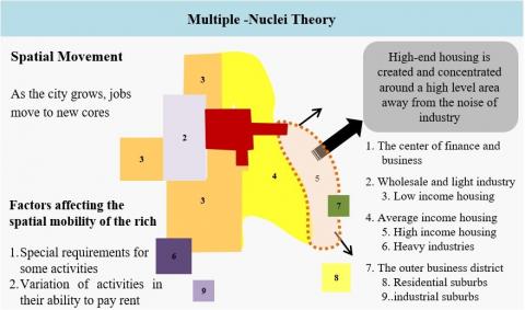
3.1.3 Multiple-nuclei theory
C.D. Harris and E.L. Ulman noticed that the luxurious residential district is established on a higher land in terms of topography away from noise in the fifth sector of the city. The main factor that affects this localization is the activity needs and the variance in activities' capabilities to pay rent [18]. Figure 6 shows spatial mobility according to the multiple-nuclei theory.
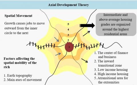
3.1.4 Axial development theory [20]
This theory takes the main axis of mobility (roads, train rails) and the urban sprawl and topography as the main factors that affect land use and land value changes, and on the changes is the location of upper-class residences. Figure 7 shows spatial mobility according to axial development theory.
3.1.5 The ecological theory
It was established by Hawley in 1957. He stressed that land price is the main and determining factor to land use and that new residences of people with higher income usually are located on low-cost land.
Figure 4. Spatial mobility according to the zone theory
Figure 5. Spatial mobility according to sectors theory
Figure 6. Spatial mobility according to multiple-nuclei theory
Figure 7. Spatial mobility according to axial development theory
3.2 Modern ecological theories
The modern ecological theories consist of Vance’s urban-realms model [19], concentric zone, and sectors [17], Kearsley model [19], and white model of the 21st century city. Figure 8 shows the spatial mobility and localization of the upper class according to modern ecological theories.
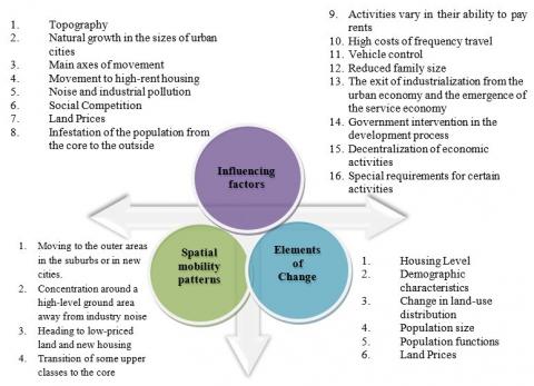
The following Figure 9 shows the conclusion of the main factors that affect the spatial mobility of upper classes as well as the spatial locations they move to and the changing variables affected by this mobility to the new locations according to the ecological theories.
Figure 8. Spatial mobility and localization of the upper class according to modern ecological theories
Figure 9. Spatial preference of the upper classes and the factors affecting and the resulting elements of change
Figure 10. The direct ties between these theories and the Greater Cairo region [21]
The overview of the earlier group of theories revealed direct ties between these theories and the specific context (the Greater Cairo Region) under research and analysis, is shown in Figure 10.
Theories emphasized either the relocation of the higher classes to the outskirts of suburbs, new cities, and satellites away from the noise of industry, and around places with high levels, low prices, and accessible spaces, or their location in centered and interior areas close to the city center, where there are more activities, jobs, and services. The factors influencing upper-class spatial mobility are the dynamics that contributed to the establishment of ecological theories in Cairo's urban fabric. In the case study, it was discovered that the actual spatial patterns of movement of the upper classes in the Greater Cairo Region are similar to the concept of the Concentric Zone Theory, the sectoral and radiative theory, and the Kearsley model in terms of upper-class outward movement. The displacement began in villages close to Cairo's ancient regular urban fabric, including Heliopolis, Mohandiseen, Maadi, and Nasr City. With rapid urban growth and expansion, as well as the establishment of urban development policies, the displacement continued to the outskirts and suburbs of new cities, to the lands of their expansions and extensions, and to the interstitial areas between new cities and the old Cairo urban cluster [22]. The case study may also be related to theories about the factors influencing upper-class housing preferences, such as proximity to highlands, distance from sources of pollution and noise, desire for large spaces at low prices, proximity to service centers, and foreign investment areas. However, given urban policies that direct urban development of the old heartland areas through the development of unplanned areas, historic Cairo, and Fustat Gardens, this may contribute to directing private sector investments to the core areas to establish activities and services, in coincidence with the completion of the growth of the New Administrative Capital in eastern Cairo and the transfer of ministries, institutions, and governmental bodies outward. This may enable the population spread outward while concentrating activities and services in the central core.
Egypt has passed through many key events through its modern history, which affected its social and economic systems, generally resulting in changes in the characteristics of the Egyptian urban setting. Following the interrelations between the political, economic, social forces and the characteristics of the Egyptian social and urban setting, it is evident that there are clear causal relationships between them. These relationships are represented in each stage in the general state policy and directions, as well as economic and social policies and measures that shaped the country’s social setting. In this part the spatial mobility of upper classes in Greater Cairo Region will be tracked as a case study in each time interval, highlighting the factors and political, economic, and social changes that affected this mobility. The impacts on social, economic, urban environments are studied as well.
4.1 Case study methodology
Greater Cairo Region is the beating heart of Egypt because of the population that represents about 19% of the population. The metropolitan area witnessed deep transformations of shapes, roles, compositions, and variety of urban functions. In addition to its absolute priority, the metropolitan area houses major development operations, construction projects, as well as governmental and private foreign investments. In parallel to urban expansion and the dense horizontal movement of population within the urban context, the spatial mobility of upper classes was evident as one of the components of the social structure. Some factors, that were not known before, intersected at the early stages of the growth of the metropolitan area. The factors that distribute the wealthy families were changed from social and security to economic factors such as the geographical location, social context and level of services and utilities. One of the main factors is accessibility via highways, accompanied by the rise of recreational uses in the western and northwestern side of the Nile all along the way to Mansoreyyah, as well as the compounds at the southern segment of Cairo- Alexandria desert road. The luxurious residential districts can be seen in the northeastern part of Cairo (Nasr city and Heliopolis) as well as Maadi district and New Maadi district and Dokki and Agouza districts at the west [23]. Through time and the changes in functions and activities, a new set of factors that pushed the upper classes to the new locations emerged, as these luxurious districts started to suffocate with informal areas, were surrounded by poor neighborhoods, in addition to the signs of crowdedness in parking areas and traffic congestions. They also lost a lot of their privacy and calmness. This pushed the residents to own a second house or move to new satellite cities in 6th of October and New Cairo, within the new cities’ districts or gated communities. The low cost of utilities for new gated communities helped to increase competition in showing luxuriousness which alarmed the appearance of elite communities. New suburbs had many recreational facilities made by the new gated communities that attracted more recreational facilities to serve the wealthy community needs, and to promote this type of luxurious compounds [23].
The spatial mobility of upper classes in Greater Cairo is a complex and continuous dynamic process with tangled dimensions and aspects, as well as impacts and causes. Therefore, it is important that Greater Cairo Region is chosen as a case study for Egyptian context, to understand and analyze this phenomenon starting from 20th century until present times. The following Figure 11 shows the methodology to study the Greater Cairo Region.
Figure 11. Methodology to study the Greater Cairo region
4.2 Indicators to define upper classes of Greater Cairo region
The first steps to the case study methodology discuss the population growth of the upper classes in the Greater Cairo Region as of the beginning of the twentieth century to date. However, researchers faced a challenge in estimating the size of these classes at the early stages of the century until the 1970s, given the lack of data. The first censuses of the Egyptian Central Agency for Public Mobilization and Statistics were in 1976, so the researchers depended on previous studies and literature such as the Egyptian Upper Class between Revolutions, 1919–1952 by Magda Barakat, which estimated the upper class population until 1952 Revolution to be (43,000 families), representing 6.5% of the total population size of urban agglomerations [8].
As for the estimated population size of this class from the 1950s to 2006, some indicators were used to determine its characteristics, depending on two previous studies, the first was the (Study of the Ecology of the Arab city and Study of the dynamics of the development of the city of Cairo during 1947-1986) [24]. The The second was the Study of urban Binaries in the Greater Cairo region; Reading the Phenomenon and Future Scenarios [25]. Deduced indicators were: (illiteracy rate - university graduate percentage - female employment percentage- unemployment rate - average household size– housing types).
The study was sometimes constrained by the availability of some indicators in a census and some other times by their absence. The following table shows the relative distribution of the population size of the upper classes, distributed spatially in the Greater Cairo neighborhoods (Central Agency for Public Mobilization and Statistics, General Census for Population, Housing and Establishments, 76-86-96-2006-2016). Table 1 shows indicators for determining the upper class according to theoretical indicators and previous study indicators [26].
Table 1. Indicators to identify upper classes according to the theoretical indicators and previous studies
|
Census Data |
Indicators |
Upper Classes Population |
Districts of Upper Classes in Inner City and New Satellite Cities |
|
1976 |
|
992620 (16%) |
Quasr al-Nile; Heliopolis; Nasr City (1); al-Nozha; al-Agouza; Dokki; al-dhaher; Old Cairo; Zaytoun; Shubra; Old cairo moved to middle-class by 1986 and other districts joined. 15th of May; Abdeen; al-Waily; 6th of October (1); Ain Shams. |
|
1986 |
1,836,304 (20%) |
||
|
1996 |
|
1,187,107 (11%) |
Zamalek; Quasr al-Nile; al-Nozha; Heliopolis; Dokki; 15th of May. Previous districts remained in 2006 and other districts joined. Maadi; Nasr City (1); Nasr City (2); al-Sherouq; Shiekh Zayed; al-Agouza; al-Obour; 6th of October (1); 6th of October (2); New Cairo (1); New Cairo (2); New Cairo (3) |
|
2006 |
1,664,788 (12%) |
||
|
2017 |
3,335,139 (19%) |
The same districts of 1966 and 2006 remained nd other districts joined. Benha (2); al-Moqattam; al-Ahram; 6th of October (3) |
4.3 Tracking the evolution of spatial mobility of upper classes in Greater Cairo region and the affecting factors starting from the beginning of the 20th century to present time
4.3.1 Spatial mobility of upper classes in Greater Cairo Region (until 1950s)
Class label. Egyptian upper class [8].
Class defining indicators. Land ownership; wealth; holding higher state positions; residence location; racial descents.
Characteristics: upper class consist of lofty people and prominent landlords who are identified by:
- Racial descents: lofty people are from Turkish origins while prominent landlords are mostly from Egyptian countryside.
- Wealth: lofty people enjoyed grand giving and prominent landlords had gifts in a form of land.
- Holding higher public positions: lofty people monopolized higher positions while prominent landlords held local positions.
- Residence location: lofty people lived in the city while prominent landlords lived in countryside.
Number of higher classes families estimated at 25,000 family that represents 5% of all families of urban areas, concentrated in Cairo and Alexandria. The neighborhoods are self-sufficient of services and have wide roads and luxurious mansions. Individuals in this class that own the land and monopolize economic activities.
Spatial mobility. moving from traditional districts in Abassiyah, Azbekeyah, Mounirah, New-Helmeia to Heliopolis, Garden city. In the 1940s more movement went to Zamalek and Heliopolis.
Housing pattern. Mansions, Villas, Palaces, and big bourgeois apartments.
Driving factors. Economic and social factors had the bigger impact in the mobility, most importantly (the urge from wealthy people to have quietness and security after the invasion of working class, and the atmosphere of industrial and commercial expansion. Urban factors included proximity to train stations and tramway or cafes and theaters and hotels [8].
Impacts of mobility.
Figure 12. Spatial mobility of upper classes in Greater Cairo region (until the 1950s)
4.3.2 Spatial mobility of upper classes in Greater Cairo Region (Nasser’s era)
Class label: Bureaucratic bourgeoisie/Egyptian major bourgeoisie/Aristocratic elite [28].
Class defining indicators: Income, profession, education, ownership, lifestyle.
Characteristics: The Egyptian upper class increased by the revolution of 1952 from 5% to 5.6% of the total population. 43,000 family were divided to 6 categories: (8% industrial organizers - 35% merchants, contractors, and mediators – 36% Bureaucrats and higher labor professionals – 21% tenants and landlords) [8]. The industry men resembled third of the upper class by the second decade of 20th century.
Spatial mobility. Upper and middle classes were kicked out from the center towards the outskirts (Heliopolis, Maadi, Nasr City, Mohandeseen). The central business district as well as Zamalek were transformed from the elite and expats residences to government employees and officials of middle class [24].
Housing pattern. Villas were replaced by dense apartment buildings in the central urban zone of Cairo.
Driving factors. Political, legislative and social factors have had a clear role in the mobility of the upper classes. This has been initiated by adopting the socialist system and a new plan for the distribution of social returns to different segments of society, thereby diminishing the influence of Egypt's large bourgeois, reducing its control over the ruling government, and the disappearance of the aristocratic elite, who were the basis of the landowners and great capitalism [29]. Luxury villas have been converted into residential buildings or used by the government authorities. The rise in population densities in Cairo as a result of persistent rural migration streams in search of employment, agricultural reform laws and industrialization processes have increased spatial mobility currents to the outskirts of the city [28].
Figure 13. Spatial mobility of upper classes in Greater Cairo region (Nasser’s era)
Impacts of mobility. In this period, urban policies and planning were directed at the middle- and lower-income classes, who suffered from insufficient services and infrastructure and low living standards in the old neighborhoods. As a result, there came the construction of both Nasr City and Al Mohandeseen, in order to meet the needs of these classes, which affected the direction of reconstruction towards the exploitation of desert lands and areas that come across the reconstructed areas. To alleviate the population crisis in the downtown neighborhoods, housing and government and administrative buildings were directed to these neighborhoods (Nasr City and Al Mohandeseen), in addition to providing land for the country's comprehensive renaissance (for housing or general projects of the State), implementing a number of axes to connect old Cairo to Masr Al Gedida, and creating additional eastern entrances to Cairo [30]. The following Figure 13 shows the upper class mobility during Nasser’s era.
4.3.3 Spatial mobility of upper classes in Greater Cairo Region (Economic openness and reform era)
Class label: Monopoly capitalists, traditional capitalists, technocrats.
Class defining indicators. Income, profession, education, ownership, lifestyle.
Characteristics. Traditional capitalists worked in all state industrial sectors and the major capitalists often worked in illegal trades.
Spatial mobility. The movement from the center to the outskirts by the upper class continued (Nasr City, Heliopolis, Maadi, Nile Waterfront, Mohandeseen,) and the size of upper classes were limited to the narrow western and eastern strip along the Nile and the outer rings of the city [24]. New communities appeared adjacent to the upper classes such as (Badr city, al-Obour, 15th of May) at the east of greater Cairo and (6th of October) at the west [31]. In the nineties, some isolated communties such as (Dream Land) at the west and (Rehab & Madinaty) at the east or in new cities at the east and the west of Cairo (al-Sherouk, Shiekh Zayed, 15th of May, New Cairo, New Heliopolis) [25].
Housing pattern. Townhouses (which are small attached or semi-detached villas) as well as twin houses, mansions, detached villas, big apartments in high-rise buildings.
Driving factors. The economic, social, and urban factors played a role in increasing the gap between classes and the creation of parasitic social class that made its livelihoods through illegal activities, as well as in the increase in crime rates and unemployment. The Egyptian economy was directed towards non-commodity sectors [11], such as the expansion of luxury housing, the establishment of gated communities, the tourism of wealthy people, as well as increase in private sector transportation, Major investments were established at the south east of 6th of October city such as road networks and main axis (26th of July Axis). as well as the regional services at the east and the west of Greater Cairo (Whole sale markets, Misr university for Sience and Technology, and mist University of Modern Silences and Arts) [32].
Impacts of mobility. The disruption of Cairo's social and class structure, lead to its loss of group balance. A booming market for luxury housing towers in Egypt's elite neighborhoods has emerged due to a strong demand for a new segment of luxury housing, particularly in the affluent districts of New Cairo, El Mohandeseen, and Nasr City. This demand was specifically for spacious units in high-rise towers. Rising demand for office space in Cairo also resulted in a booming market for business towers, specifically catering to companies, banks, and the influx of new local and foreign entrepreneurs entering the Egyptian market. Land prices in Egypt have witnessed a remarkable surge, particularly in newly developed areas. The conception of the first master plan for Greater Cairo in 1983 was a response to numerous challenges facing the region at the time, namely: uncontrolled urban growth, attracting population increases from northern and southern industrial zones, implementing the homogeneous sectors method (the region was divided into sectors with similar social, economic, and urban characteristics), and constructing the ring road (this highway was built to separate the core urban area from the new cities). The idea of homogeneous sectors was abandoned, especially in several areas east and west of Cairo, where most of the spaces between the old urban fabric and the new cities were allocated to new urban extensions (Shorouk - New Heliopolis) or to expansions introduced to some urban agglomerations (Obour - Badr - New Cairo - Sheikh Zayed). This led to a change in the policy of homogeneous sectors. Figure 14 illustrates the spatial mobility of upper class throughout the Econimic opennes and reform era [33].
Figure 14. Spatial mobility of upper classes in Greater Cairo region (Economic openness and reform era)
4.3.4 Spatial mobility of upper classes in Greater Cairo region (new economic reform program)
Class label. Wealthy, who can Afford, high-income people.
Class defining indicators. illiteracy, university degree holders, working women, higher profession workers, unemployment, family size, type of tenure, type of household [24, 25].
Characteristics. A new social class of mostly young businessmen, workers at foreign banks and private sector companies, they were defined as the upper-middle class [9].
Spatial mobility. Movement was towards the outskirts of the city to the 4th generation new cities (New administrative capital, New October, new Shiekh Zayed, New al-Obour, Mostakbal City, Sphinx, New Heliopolis) wether in gated communities or in premium housing state owned projects (e.g., Jannah) with the continuation of the movement to 5th settlement and Shiekh Zayed, etc. Part of upper class, however, is still dwelling in inner districts (Mohandeseen, Zamalek, Maadi, Dokki, Nasr City, Heliopolis).
Housing pattern. Premium housing and lifestyle such as townhouses and twin-houses, mansions, detached villas, big apartments in high-rise buildings [9].
Driving factors. There are many factors that stimulated the mobility of upper social classes in this era (Political, environmental, economic, and urban, and social). One of the factors is the nature around agriculture lands that provide calmness and quietness as the case in New Sphinx City. Other factors included the decreased temperature and the preferred micro-climate in some new cities in comparison of the old urban settlements, where there are high levels of pollution and noise, in addition to challenges of the heat island effect as well as the increased emissions of GHG [34]. This era is also characterized by the state direction to establish new 4th generation sustainable cities, such as the new administrative capital and the competition of the private sector in providing units and lands for premium housing. This era also whitnessed the establishment of various projects to increase accessibility via developing the transportation sector (Metro, tramways, Highways network). The highways network development included projects such as (6th of October, Nasr, 15th of May highways, Mosheer Tantawy axis, Regional ring road, al-Awsaty ring road, Daba’a Axis, and Rawd al-Farag Axis). Several regional services were established such as (Conferences center, City Stars, Cairo Festival City, Mall of Arabia, Mall of Egypt, Nile University, Mosheer Tantawy Mosque, Downtown, International exhibition center, Hyper One, and other cultural, heritage and recreational projects). In addition, the successive expansions of cities and the huge land allocation for premium housing was also evident in this period [35]. The state also focused on the redevelopment and rehabilitation of the city center by a number of projects such as (Historic Cairo rehabilitation project, the infrastructure and utilities and social services development and completion of the upgrading of informal and un-planned areas.
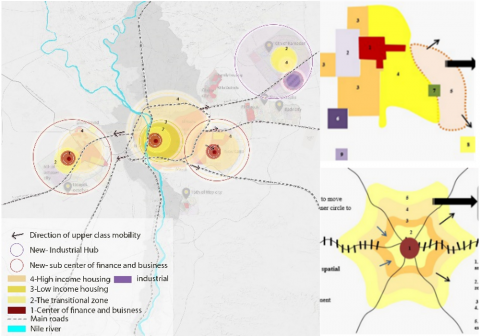
Impacts of mobility. Rapid high demand of the upper classes for luxury housing continued, in addition to the liberalization of the exchange rate that has increased the prices of construction materials and thus raised the real estate prices, resulting in the emergence of new housing patterns in the luxury housing market to keep pace with these increases in the real estate market, such as reducing the areas of residential prototypes and introducing studio and penthouse housing types. The increasing demand for luxurious housing has also led to the expansion and extension of existing new cities as well as increasing the distances between the old and new urban masses, and the spread and high growth rates of gated communities, which have become a manifestation of random modernity. These communities may contradict with the concept of green architecture and the inclination towards energy saving. The random mobility has also resulted in a dysfunction in the relative and spatial distribution of housing patterns, especially in the cities located at the west of the Region) where luxury housing is concentrated in the northern and eastern expansions of October, and the rise of luxury housing from 14% to 25% in the current plan for 6th October City. The rapid progress of the development and reconstruction in the east and west of the region has led to directing the private and public sectors investments towards such development, especially after launching a number of development projects, in particular road projects, regional and national axes and transportion [32], establishment of the New Administrative Capital, the fact that increased the demand for the real estate, especially in the east of the region. The limited availability of land in the western zone of the region is the main and major cause of the rise in real estate prices. With the development and improvement of the heart of Cairo and the launching of a series of development projects such as the Development of Historic Cairo, Fustat and other projects, the Greater Cairo Region is being transformed into a multicultural and multipolar region [32]. Figure 15 presents the upper class’s mobility during the new economic reform program.
The following Figure 16 presents the upper class’s mobility during the new economic reform program.
Figure 15. Spatial mobility of upper classes in Greater Cairo region (new economic reform program)
The availability and engagement of stakeholders (i.e., State, private sector, consumers) in each period has a significant role to play in the spatial and housing patterns of the upper classes. As a result of the State's adoption of the policy of socialism and the resulting marginalization of the role of the private sector, spatial segregation between classes has emerged. The adoption of market openess and reform policies resulted in the remergence of the role of the private sector and the high demand for luxury housing, which has resulted in turn in the increase of gated communities in the region’s new cities. The continued spread of these communities is also the result of the global and local economic and political conditions and significant challenges at both levels. The research aim is to understand the nature of these dynamic processes in an attempt to put them into a theoretical framework. Despite the unique conditions and specificity of the Greater Cairo Region, it closely resembeled in the movement of its upper social classes the class movement of ecological theories. Each period resembled one or two more theories. The following are the most important research results.
5.1 Context of the spatial movement of the upper classes of the Greater Cairo Region
There are three important and conclusive time phases in the formation of the spatial patterns of the upper classes in Egypt. In the first phase of urbanization in the 1960s (Nasser period from the 1950s to the early 1970s), the spatial pattern had been formed as a result of specific political, social and legislative factors that resulted in the expulsion and displacement of the upper classes from the center on the city to the nearby suburbs. This pattern affected the deterioration of the heart and the center of the city. The second phase was the era of economic opening-up of the 1970s, which witnessed the continuous pattern of displacement and expulsion of the upper classes from the centre to the suburbs and neighborhoods of new cities. The new pattern of gated communities has emerged as a result of the new economic, urban and social factors. This has led to the continued deterioration of the heart of the old city and the development of the new outskirts and suburbs. As for the third phase, the pattern of spatial mobilization of the upper classes was between either remaining in the center of the city, or their movement to the gated communities and the distinct neighborhoods of the new cities in the outskirts and suburbs. This phase may be considered the urban disintegration phase, that turned out to a re-urbanization phase. In the light of the development and improvement projects of the heart of the city, Figure 16 illustrates a summary of the dynamic spatial mobilization of the upper classes over time from the twentieth century to date.
5.2 Theorizing spatial mobility of upper classes of Greater Cairo Region from the beginning of the 20th century until the present day
Theorization of spatial mobility patterns of Greater Cairo region will be considered in the three time intervals used in the above analysis: from the beginning of 20th century to 1970s, the second stage from 1980s until the economic reform era, and the last stage is from 2006 to present day.
5.2.1 Theorizing spatial mobility of upper classes of Greater Cairo Region from the beginning of the 20th century until 1970s
After tracing the development of the upper classes' spatial mobility in the Greater Cairo Region until 1970 and studying the economic, urban, social, and political factors influencing this mobility, it was observed that this movement from the inner to the outside rings is similar to the processes of both the Concentric Zone Theory and the Sectoral Theory. Figure 17 illustrates this similarity, highlighting the tendency of upper-class families with comparable economic and social backgrounds to live in the same areas, away from noise and pollution, on low-cost outskirt land with vacant spaces.
Figure 16. Context of the spatial movement of the upper classes of the Greater Cairo region
Figure 17. Theorizing spatial mobility of upper classes in Greater Cairo Region from the beginning of the 20th century until early 1970s
5.2.2 Theorizing of spatial mobility of upper classes of Greater Cairo Region from the 1980s until the economic reform era
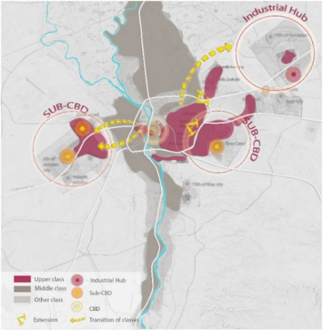
This period witnessed the implementation of economic openness, structural adjustment, and economic reform policies, as well as the resulting investments directed to the region. In addition, the State started to develop visions and future plans for the region's urban development through the development of the Structural Plan for the Greater Cairo Region in the early 1980s. This plan advocated the development of a number of new urban centers (new cities) in the east and west of the region, and a series of state development projects, the most significant of which were related to the transportation system (the Ring Road, the 6th of October Corridor, the 26th of July Corridor, the Al-Azhar Tunnel, and the Regional Ring Road). As a result, new cities drew in new major service and economic institutions, and they were able to attract as development centers whose circles of attraction extended beyond the main urban mass of the city. The outer edge centers became generating areas as well as destinations. The convergence of new liberating political, economic, and urban factors has resulted in the rise of luxury urbanism in the east and northeast directions. As the elite moved from Heliopolis and its extension in Nasr City and Old Maadi to the Fifth Settlement, New Cairo, Madinaty, Al-Rehab, and the beginning of the Cairo-Ismailia Desert Road to the east. The rich and elite of the inner upscale neighborhoods were also moved to the west and northwest, from the Nile River's banks to the Mansourieh Canal, and to the residential resorts on the southern section of the Alexandria Desert Road. As such, the movement of the upper classes in Greater Cairo may be similar to the theory of Multiple Nuclei, in which several subsidiary service and investment centers have evolved away from the main central business district. At the level of each nucleus, it can be diagnosed in light of the radiation or axial theory, as shown in the Figure 18.
Figure 18. Theorizing of spatial mobility of upper classes of Greater Cairo region from the 1980s until the economic reform era similar to multiple-nuclei and radial theory
Figure 19. Theorizing of spatial mobility of upper classes of Greater Cairo region until the third wave of new economic reform Similar to multiple-nuclei Theory and ring theory
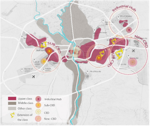
5.2.3 Theorizing spatial mobility of upper classes of Greater Cairo Region until the new economic reform
Between 2006 and 2022, relocation out of the city continued as a result of the region's rapid population growth, the central core deterioration due to the expansion of slum areas, traffic congestion, and the spread of urban extensions of secondary urban centers (6th of October and New Cairo), and the establishment of other new communities (Sheikh Zayed, October Gardens, New October, Sun City in the west; Nour City, Mostakbal city, and the New Administrative Capital in the east). These cities have grown into significant service hubs, including 6th of October, Sheikh Zayed and its extension, New Cairo as a financial and commercial center and its extension, and the Administrative Capital as a major development pole. In light of the of the region’s diagnosis, each of the peripheral urban centers, such as New Cairo and 6th of October, and their extension, may be similar to the Multiple Nuclei theory, where upper classes are close to administrative districts and business centers and far from industrial areas. The gradual amalgamations of modern urban blocs in old Cairo resulted in each peripheral urban center resembling the Radiative or Axial theory, where it is concentrated in areas near transportation and movement hubs, as well as on the fringes of urban blocks (Figure 19).
Every urban region has a system with driving forces that ensures its autonomous operation, and it can be managed to drive development towards specific goals. The quality of this system is determined by how quickly inputs and outputs flow through it. It also experiences issues as a result of the slowness in its reciprocal movement. As a result, the flow of energy or movement between the central region and the outer edge (margin clusters) is hampered by some aspects of imbalance, which future studies must address and suggest suitable solutions. The study tracking the course of spatial mobility of the upper social classes in the Greater Cairo Region as a case study from the beginning of the twentieth century to the present showed various obstacles and issues that might be examined further. Examples include exposing the hazards of human marginalization, which are worsened by peripheral elite communities (gated communities), identifying the distribution of socioeconomic classes and the gap between them, as well as their residence and movements within the city complex. This research may help understanding and predicting the future of population movement in the upper classes within the movement of their displacement to the margins. Further research is needed to assess the movement of population from historic center districts and their migration to modern marginal neighborhoods, the consequent population densification or disturbance in urban regeneration processes, the impact on population density, as well as the energy flow maps inside the urban system to align with the concepts of sustainable development.
This research findings, however, cannot be generalized to other regions and urban areas within the Egyptian context. Each urban region has a distinct condition resulting from demographic, economic, social, urban, legislative, topographical, and environmental factors. The Greater Cairo Region is also considered special since it is Egypt's throbbing heart, distinguished by its historic history and global significance. It is also regarded as a global metropolitan city, a significant location for international institution headquarters and the site of big worldwide events, as the region is adopting ambitious development plans to maintain its leadership in the Middle East and North Africa. As such, it is always prioritized in development, improvement, and construction interventions, as well as in directing governmental and foreign private investment Moreover, its population, accounts for approximately 19% of the Republic's population, characterized by the diversity of urban jobs. In contrast to other Egyptian cities, it has evolved into a megalopolis, composed of various multi-nucleated districts and metropolitan areas that are agglomerated and linked together.
[1] Loyseau, C. (1994). A Treatise of Orders and Plain Dignities. Cambridge University Press, UK.
[2] Pottle, F.A. (1953). Boswell on the Grand Tour: Germany and Switzerland. William Heinemann Ltd., UK.
[3] Doyle, W. (2010). Aristocracy, Atef, Zainab & Suleiman, Hani (translators). United Kingdom: Hendawi Foundation for the Dissemination of Knowledge and Culture, UK.
[4] Wells, H.G. (2017). Rich and Poor. Zaki, Najib Mahmoud, (translators). Hendawi Foundation, Egypt.
[5] Rahman Khan, S. (2012). The sociology of elites. Annual Review of Sociology, 38: 361-377. https://doi.org/10.1146/annurev-soc-071811-145542
[6] Aboulela, S. (2020). The elite and political and social awareness "analytical view". Journal of the Faculty of Literature. Beni Suef University, 4(55): 137-158. https://doi.org/10.21608/jfabsu.2020.143099
[7] Shalabi, T.M. (2009). Community study programme; Social development, first level, second semester. Benha University, Faculty of Arts, Egypt.
[8] Baraka, M. (2009). The Egyptian upper class between two revolutions, 1952-1919. Translated by Majid, M. Cairo, Egypt: National Center for Translation.
[9] Magdy, M. (2006). Town and twin house residential units suitable for the new social segments of the upper middle classes. Journal of the Egyptian Statistical Society, 10196.
[10] National Center for Social & Criminological Research. (1985). A proposed framework for the study of class construction. Cairo, Egypt.
[11] Shehata, Y.E. (2018). Economic reform and the culture of consumption in Egyptian society. Journal of the Faculty of Arts, Port Said University, Egypt. https://doi.org/10.21608/jfpsu.2018.57661
[12] Abdelam, A.M. (2014). Cultural change in Egyptian society in the last half of the twentieth century: An analysis of the constant and variable in the structure of culture. Ain Shams University, Faculty of Arts, Department of Sociology, Egypt.
[13] Marai, I. (2021). Studies on social and cultural changes in Egyptian society. Al-Ahram Center for Political and Strategic Studies.
[14] Briassoulis, H. (2020). Analysis of Land Use Change: Theoretical and Modeling Approaches, the Web Book of Regional Science. Regional research institute, West Virginia University, USA.
[15] Awad, E.H. (1997). In urban sociology: The population of the city, time and space. Scientific Bureau of Computer, Publishing and Distribution, Egypt.
[16] Wahiba, A.M. (1973). In the urban geography. Dar Al-Nahda Al-Arabiya for Printing, Publishing and Distribution, UAE.
[17] Balchin, P.N., Bull, G.H., Kieve, J.L. (1995). Urban Land Economics and Public Policy, Fifth edition, Publisher: Red Globe Press London.
[18] Ismail, A.A. (1990). Studies in the geography of cities. Cairo: Publishing, Culture and Distribution House, Egypt.
[19] Pacione, M. (2009). Urban Geography a Global Perspective. Routledge, UK.
[20] Harvey, J., Jowsey, E. (2004). Urban Land Economics. Basingstoke: Palgrave Macmillan, England, United Kingdom.
[21] Mosilhi, F.M. (2017). The Arab city and the challenges of urbanization in changing communities: Greater Cairo as a model. Omran, Arabia. https://omran.dohainstitute.org/ar/issue020/Pages/art02.aspx.
[22] Abu Ghazaleh, A.A. Muhammad, H.A. Mohi El-Din, I.M. (2012). Urban development of Cairo (Solutions and problems). Engineering Sector Journal - Al-Azhar University, Egypt.
[23] Ministry of Housing, Utilities and Urban communities, General Authority for Planning. (2014). Urban structure project for the Greater Cairo region: Study of the regional vision and the limits of the study. Cairo: Ministry of Housing, Utilities and Urban communities, General Authority for Planning, Egypt.
[24] Abdel Moneim, W.A. (1990). The ecology of the Arab city and a study in the dynamics of the development of the city of Cairo (during the period 1947-1986). PhD Thesis, Department of Architecture, Faculty of Engineering, Cairo University, Egypt. https://arch.eng.cu.edu.eg/post.aspx?pid=200.
[25] Sibawayh, M.H. (2013). Dualities of urbanism in the Greater Cairo region: A reading of the phenomenon and future scenarios. PhD thesis, Faculty of Regional and Urban Planning, Cairo University, Egypt. http://lis.cl.cu.edu.eg/cgi-bin/koha/opac-detail.pl?biblionumber=43864.
[26] Central Agency for Public Mobilization and Statistics. (2006, 2017). General population census.
[27] Mohamed Riyad. (2014). Cairo: The fabric of people in space and time and its problems in the present and future. Hindawi Foundation for Education and Culture, UK.
[28] Eltahawy, H.M. (2011). Economic openness and its impact on the middle class. Mansoura University, Faculty of Arts. Arab Center for Research and Studies, 48(2): 600-660.
[29] Barakat, A. (1977). The development of agricultural ownership in Egypt, 1813-1914: And its impact on the political movement. New of Culture, Egypt.
[30] Shaheen, S. H. (2017). Nasr City: The city of the middle class (Egypt in the sixties). Tariq Wali Center for Architecture and Heritage, Egypt.
[31] General Authority for Urban Planning. (1983). Studies of urban development axes from the 1982 plan: Structural plan for the Greater Cairo region. Ministry of Housing and Urban Development, Egypt.
[32] Mosilhi, F.M. (2008). Population and Social Studies. Ministry of Housing, Utilities and Urban Development (Arab Republic of Egypt), General Authority for Urban Planning. Strategic Planning for the 6th of October Governorate, Egypt.
[33] Mosilhi, F.M. (2013). Elite urbanization in the suburbs of Greater Cairo, Arab Republic of Egypt. Ministry of Housing, Utilities and Urbans Development, General Authority for Urban Planning. Urban Structure of Greater Cairo, Egypt.
[34] Yousry, M. (2021). The general strategic plan for Sphinx city: Preparation of current situation studies and analysis. Volume II and III, Egypt.
[35] Goumaa, A.A., Abdel Rasool, A.S. (2020). Urban gaps between new and existing cities: A case study of East Cairo. Journal of Engineering Sciences, Assiut University, Faculty of Engineering, Egypt. https://doi.org/10.21608/JESAUN.2020.135081