Aulia Arfida Paramita*![]() | Haryo Winarso
| Haryo Winarso![]() | Delik Hudalah
| Delik Hudalah![]() | Ibnu Syabri
| Ibnu Syabri![]()
© 2023 IIETA. This article is published by IIETA and is licensed under the CC BY 4.0 license (http://creativecommons.org/licenses/by/4.0/).
OPEN ACCESS
This paper explores the institutional perspective of megaprojects and their transformational impacts. It investigates how institutional design and changes contested by multiple actors over time lead to path-dependent trajectories, resulting in specific development outcomes and impacts within and beyond the megaproject site. The North Jakarta Bay Reclamation (NJBR) megaproject is selected as a case study due to its long-term development and highly political context. Using a qualitative approach, the research applies content analysis to secondary resources such as laws, regulations, policy documents, working papers, and newspapers. Primary data from field observations is also incorporated. The findings reveal that the institutional design of the NJBR megaproject has influenced development paths for both the site and another urban space in the region. Despite the suspension of reclamation activities, institutional path-dependency from previous administrations’ terms resulted in expedited permits and several regulations has allowed the construction to continue on two specific reclaimed islands in the NJBR megaproject. Consequently, as these two reclaimed islands have been developed, bridge infrastructures connecting the mainland of North Jakarta, Tangerang Regency, and parts of the NJBR megaproject have been established, bringing significant impacts on a larger scale. One of the most evident impacts is the increase in land values in different areas due to the established infrastructure networks, exemplifying the impact of path dependency beyond the megaproject. By adopting an institutional perspective on megaproject planning and development, this study enhances our understanding of the contemporary theorization of megaproject impacts. It highlights that transformational impacts are not solely attributable to the creation of megaprojects, but are rather the outcomes of path dependency and institutional change during the megaproject development process.
megaproject, development impacts, path dependency, historical institutionalism, qualitative research, case study
Del Cerro Santamaria [1] defines urban megaprojects as “large-scale urban development projects usually aim at transforming a city’s or parts of its image, and are often promoted and perceived by the urban elite as crucial catalysts for growth and even as linkages to the larger world economy”. Due to the massive use of resources and huge impacts from their transformational ventures, urban megaprojects have a different complexity compared to other projects in terms of design, management, uncertainty, multiphasing, impacts, etc. [2]. Megaprojects are more than just “enlarged version of smaller projects”; they have very different complexity, problems, structures, and power dynamics [3, 4]. As many stakeholders from different institutional frameworks with diverse objectives and interests are involved in managing resources and impacts, institutional complexity and power dynamics arise in megaprojects [2, 4].
It is widely acknowledged that major transformation from megaprojects development often trigger larger impacts beyond the boundaries of their sites over long period of time [5, 6]. Several impacts of megaprojects manifest through economic, social, and physical changes as the development reshapes the built environment and even triggers new development in other spaces [1, 5, 7-9]. However, comprehensive impacts of megaprojects on large spatial and long temporal scales often cannot be fully predicted in the early stage of planning [3, 10, 11]. In this sense, it is necessary for the actors to regularly monitor and measure the impacts, taking into account the changing conditions over a long period of development, and prepare institutional designs that direct and provide choices of rules for policy-making [12, 13]. Consequently, as many actors put much effort in institutional design and change over time, megaprojects can transform spaces into a more densely institutionalized space that lead to certain developmental paths [5, 14]
Institutional arrangement becomes an essential driver of megaprojects’ transformational impacts. However, little attention has been devoted to understanding the major impacts of megaprojects from an institutional perspective. We argue that the impacts of megaprojects are not only realized through their physical or functional transformations but are also embodied in institutional restructuring during the development process. The institutional design and change can directly drive physical, economic, and environmental changes within and beyond megaprojects sites. In the other cases, institutional change such as “legal, political, and policy changes can also shift meaning of built environment in material ways without implying any physical change at all, e.g., rezoning, change of building code” [14]. In this article, we see that institutional design and change can limit possible choices and then lock them into particular developmental paths in the future [15]. The established institutions determine development outcomes in the short-term as well as physical, economic, and environmental impacts in the long-term.
Megaprojects become contested arenas for institutional change. Although institutional change is needed to mitigate impacts and adapt to changing conditions during development, in practice, the changes of regulatory frameworks and policies are often made to support individual interests. Thus, we need to differentiate between the ability of actors to change the institutional settings when responding to exogenous change, e.g., crisis or external disturbances, in order to manage development impacts [16], and the ability of actors to naturally mobilize their interests that do not meet the prevailing institutional settings [17]. In megaprojects development, dominant actors are often given special power to ignore, contravene, or change the prevailing institutional arrangements in local, regional, and even national level [18]. As a result, increasingly complex institutional design and change can give rise to a range of intended and unintended consequences, which may diverge from the expected development outcomes and impacts initially envisioned.
Given the inherent complexity of the institutional dimension of megaproject, this paper employs Historical Institutionalism (HI) to unravel the institutional design and changes, as well as influential decisions within the megaproject. HI offers valuable insights into how choices made in decision-making regarding institutional arrangement at one point in time have significant effects on the range of possibilities available at the next period [15]. This, in turn, leads to path-dependent trajectories resulting in specific outcomes and impacts [15]. Therefore, by utilizing HI, we can comprehend crucial moments in megaproject when influential decisions were made and adopted within institutions, the dynamics of decision-making processes among actors, as well as the resulting development outcomes and impacts that benefit specific actors over time.
Within the urban development context, such as megaproject, institutions in HI encompass the form of laws and regulations governing urban land and property issued by the governments [14]. In HI, there are specific times when selected choices result in increased durability of institutions in the future, as conceptualized in the notion of path dependence and critical junctures. First, institutional development in the initial phase is considered a critical moment. As explained in path dependence, such moment can limit available choices and create a state of ‘lock-in’, wherein actors tend to adapt to the prevailing institutions in the future trajectories [15]. Actors who benefit from an institution often exhibit a substantial positive feedback, as they are incentivized to hinder changes that could diminish their power or rewards [14]. However, there are also moments when major exogenous changes (related to economic, political, or environmental conditions) create an opening and invite actors to modify the institutions, as elaborated in critical junctures [14]. During such moments, we can observe the contestation among actors in institutional change, potentially shaping new pathways or defending existing patterns, resulting in specific development outcomes and impacts within the megaproject.
This article addresses the research question: How does institutional path dependency influence development outcomes and impacts within and beyond a megaproject? In detail, we investigate the specific moments lead to significant decisions within institutional change, the extent to which institutional design and change contribute to development pathways in the megaproject over time, as well as short-term development outcomes and long-term impacts generated both within and beyond the megaproject site. In this paper, our aim to deepen the understanding about how institutions give rise to path-dependent trajectories, resulting in specific development outcomes and impacts within and beyond the boundaries of megaproject site.
To illustrate the concept, this paper focuses on the North Jakarta Bay Reclamation (NJBR) project as a case study. NJBR is an urban megaproject located in the North Coast of Jakarta, the capital city of Indonesia. Initiated since 1995, the project involves large-scale land development of 17 artificial islands. The institutions governing NJBR exhibit path-dependency, in which institutions become difficult to change and reverse, and are used to accommodate interests and objectives of the influential actors. Our analysis demonstrates that the path-dependency of megaproject institutions is a primary driver in generating development outcomes and impacts within and beyond the boundaries of the megaproject site.
The next section will explore the limitation of megaproject literatures and institutional theory as a theoretical approach to fill the absence of explanation. In the third section, we explain the research methodology and the North Jakarta Bay Reclamation Project as an illustrative case study. We apply historical institutionalism framework to understand urban megaproject development process in our case study. Meanwhile, the fourth section discusses the importance of urban megaproject’s institutional design on other spaces, and the last section will conclude this paper by giving a recommendation towards urban development process.
There is a paradigm shift in understanding characteristics of megaprojects from ‘old’ to ‘new’ megaprojects [19]. The former defines megaproject as a single-focus project for public good provision that has monolithic singular structure, while the latter discusses a variety of mixed-use development through more privatized form of public benefit [19-21]. Through the years, an increasing number of ‘new’ urban megaprojects have been developed in line with efforts to enhance competitiveness and raise the position of city-regions within a global system [18, 19, 22, 23]. Therefore, as their development processes involve a major transformation of urban spaces, they often trigger larger economic, social and environmental impacts beyond the boundaries of their sites (spatial scale) over long period of time (temporal scale) [5, 6].
Measuring comprehensive impacts of urban megaprojects on larger spatial and long temporal scales is a difficult work, as forecasted costs in impact assessment tend to be generally inaccurate and misleading [3, 10]. Broader socioeconomic impacts of urban megaproject development are not under the direct control of the involved actors and cannot be fully predicted in the original plan [11]. For instance, some empirical cases show that urban megaprojects lead to a gradual change in land and property prices of their surrounding areas over a long period. In the case of King’s Cross megaproject in London, the growth of residential prices rippled across locations starting from the megaproject site towards the surrounding area within a one-and-a-half-kilometer radius [5]. Another case of megaproject development, Sadr Multi-layered Highway in Tehran, also had an impact on housing prices in the adjacent neighborhood where the highest price increase was at the distance of 60-120 meter from the project site [7]. Both cases indicate that the improved connectivity as well as better access to infrastructure and amenities are the main drivers behind the price growth.
Beyond the local scale, urban megaprojects can have larger physical, economic, and social impacts on different spatial scales – cities and regions. For instance, development of Cheonggyecheon Restoration Project generated long-lasting effects on the downtown area as spatial changes incrementally occurred over a long period after the project was implemented [8]. Besides affecting land uses and structure in downtown Seoul, the project has recreated the city’s image (ibid.). In some other cases, urban megaprojects also have capacity to transform landscapes and create new development path in city-regions [1, 21]. In the case of West Kowloon project in Hong Kong, the increased transportation connectivity has stimulated more investments in property development, changing urban dynamics on a regional scale [5]. In another case, other massive investment on three urban megaprojects (Yavuz Sultan Selim Bridge, the Third Airport, and Kanal Istanbul) in Turkey has potentially triggered urban expansion towards the northern part of the city that might threaten the ecological and social stability [9].
In coping with the impacts of urban megaprojects on larger spatial and long temporal scales, the abilities of actors to measure the impacts and determine the policy strategies over time are crucial [12]. In this sense, institutional design plays a significant role in providing choice of rules for the policy-making processes [13]. One of important highlights from the cases is megaproject development involves considerable efforts in terms of institutional design and change, which subsequently shape urban form study of Hanakata and Gasco [5] by driving development outcomes as well as physical, economic, and environmental impacts within and beyond megaproject sites. As large-scale urban project involves many actors in decision making from local/regional to national level, changes to planning, policies and regulations at various scales often occur to facilitate the development [18, 24-26]. The legal framework and financial incentives are intentionally designed to attract more private investments [9]. Additionally, regulations are frequently modified to legitimize projects that were initially not accommodated or might potentially conflict with existing regulations [9]. Furthermore, the state and private sector also commonly build a robust network to provide such favorable regulatory environment for urban megaproject [27].
This study utilizes Historical Institutionalism (HI) to elucidate how complex institutional design and change of megaproject shape path-dependent trajectories that subsequently determine the development outcomes and impacts. In HI, researchers emphasize how temporal phenomena, such as the role of timing and sequence of events (conceptualized in critical junctures and path dependence), influence the emergence, change, and persistence of institutions over time [28]. Institutions emerge from and are embedded in temporal processes [15]. This emphasis is useful in reviewing the origins of key institutions as well as in explaining why institutions can survive after the initial push is no longer there [28].
Several elements need to be considered in adopting HI framework. First, path dependence, in which institutions tend to be difficult to change over time and decisions that are chosen initially can have long-term effects [29]. According to Thelen [15], “the moment of institutional formation in the beginning process leads to some certain developmental pathways; and subsequent burgeoning institutions which respond to changes in environmental conditions and political strategies tend to be limited by past trajectories”. Second, critical juncture, which is one or a series of changes that occur in a relatively short period of time but have a large and lasting impact in the future [30]. Critical junctures mark the beginning of a path-dependent process; after the critical junctures which allows relatively free agents are open, a process or series of events in which an institution indicates its causal mechanism occurs [28]. Thus, critical juncture moments invite political actors to decide choices and change the institutions that will lead to influential outcome and long-lasting impacts in the future [31].
In megaproject, the dual model of institutional development is clearly shown in the moments when major exogenous changes in broader structural context are followed by decisions and institutional change from different government levels and actors involved in the development project. Institutional formation in the early phase of development project is considered one of critical junctures that attempts to fill the absence of certain solution. The other critical junctures in development process include some moments of major exogenous changes in economic, political, and environmental conditions which are responded with significant institutional changes such as monetary crisis, regime change, natural disaster, etc. After the institution is established or changed, the (initial) idea and decision during the critical junctures continue to be perpetuated and strengthened through subsequent institutional design from which certain events are expectedly resulted over time. Therefore, a self-reinforcing path-dependent process occurs and leads the project development to certain outcomes over time.
The focus of HI in explaining temporal phenomena enables us to trace how institutions, designed at specific times and events, determine potential policy options that shape development trajectory [28]. Moreover, contestation during the institutional design and change processes also reflects which individual actors or groups prefer specific outcomes, as well as how they use their strategies to accommodate their interests within the institutions [32]. We believe that HI provides methodological value for analyzing how institutional path dependency influences development outcomes and impacts within and beyond a megaproject. In particular, the elements of HI concept enable us to provide detailed explanations. First, identifying specific moments leading to significant decisions within institutional change through critical junctures. Second, analyzing how institutional design and change influence the development paths over time through path dependence. Third, unveiling development outcomes and impacts, driven by the path-dependent trajectories.
Drawing insights from megaproject literatures, a megaproject encompasses substantial budget allocations (typically exceeding US $1 Billion), exerting considerable impacts and necessitating intricate interactions with both private and governmental stakeholders [3, 20]. Given the complex stakeholder engagement in long-term developmental processes, the significance of institutional changes under evolving circumstances becomes pivotal in shaping path-dependent development trajectories and their subsequent impacts. These theoretical underpinnings align well with our choice of case study, North Jakarta Bay Reclamation (NJBR) Project. NJBR Project is a megaproject initiated in 1995 with the purpose of creating 17 artificial islands along the coast in North Jakarta, DKI Jakarta province. The islands are named in alphabetical order from A to Q.
Our case study selection is grounded in three key rationales. First, located in the capital city of Indonesia, NJBR Project is a strategic national megaproject with massive investments around US $22 Billion and covers 5,153 ha of new land development according to the Governor Regulation No. 121/2012. Second, the dynamic landscape of institutional change of the NJBR project, evolving under varying structural conditions within shifting political, economic, and environmental contexts since 1995, correlate with the theoretical foundation. Third, historically, the planning and development of NJBR project have involved various actors in decision-making relating to institutional changes. As these changes ripple outward, the project's impacts also extend beyond its immediate site, yielding consequences that reverberate throughout its broader landscape.
We used a qualitative approach in this research. Diverse data sources were integrated during the data collecting processes to understand the history and the present context of the case study. First, we collected various secondary data resources such as laws and regulations, plan and policy documents, working papers, reports as well as newspapers to understand the institutional change and actors’ involvement in different time period from 1995-2022. Second, stakeholder interviews relevant to the planning and development of the NJBR megaproject, e.g., national and provincial governments, private property developers, non-government organizations, consultants, and local communities particularly the fishing villages were conducted. The interview results were used to scrutinize and clarify historical developmental events and decisions from the involved actors behind the institutional design and change over time.
Our data collecting and analysis processes were conducted based on the main and detailed research questions mentioned in the previous chapter. Several guiding questions were derived from them as follows: Were there any exogenous changes or crises during the project planning and development? What institutions were designed or changed in the early development stage and during such critical junctures or moments? Who were the actors, both proponents and opponents, involved and how did they contribute to institutional change over time? Which institutions are durable and adopted in subsequent institutional design in different periods? Which institutions are influential as legal basis in locking, directing and limiting the development paths within the megaproject site and other sites? What are the development outcomes, as well as long-term impacts generated within and beyond the megaproject site?
We employed content analysis to examine the data both from the secondary and primary sources to trace the evidence of institutional change that subsequently results in development outcomes and impacts within and beyond the megaproject site. In the beginning of the analysis process, we reviewed various documents regarding the laws and regulations over time to gain an overview of their contents and organize the institutional change based on the chronological order. After that, we developed a coding scheme relevant to the research objective and questions. We assigned code for specific text or segment of data from the secondary and primary sources that corresponds to one of the predefined categories in our coding scheme. Subsequently, the coded data were analyzed to identify patterns related to critical moments, institutions, sequence of development events, outcomes and impacts resulted from the development over time. Moreover, to ensure reliability of the content analysis, we applied a clear coding guideline where definition and set of criteria for each category were specified to include and exclude contents in the coding processes. Besides, we periodically checked for our coding consistency throughout the analysis by randomly selected and reviewed a sample of previously coded content to ensure that our coder applied the guideline consistently.
Based on our research objective and theoretical framework, we developed several primary criteria. These criteria served as the basis for defining and specifying detailed criteria for the categories and codes in our scheme. These primary criteria encompass: (1) exogenous changes that trigger institutional development of megaproject; (2) institutional change that significantly direct and limit development paths; (3) development events, outcomes and impacts generated within and beyond the megaproject site. From our analysis, several codes were generated and assigned under the predefined categories. For instance, in analyzing exogenous changes, we had several categories, e.g., ‘economic crises’, ‘political upheaval’, and ‘environmental catastrophes’. Several codes such as ‘regime change’ and ‘political revolution’ were assigned under the category of ‘political upheaval’.
Then, in analyzing the institutional changes, the documents of laws, regulation, agreements previously organized based on the chronological order (dates of issuance) were also sorted into several categories. We categorize them based on the form of institutional change e.g., ‘legal framework amendment’, ‘law changes’, ‘regulatory revisions’, ‘decree revisions’, etc. and based on the content e.g., ‘land development and management’, ‘reclamation’, ‘property rights’, ‘spatial planning’, ‘zoning regulations’, ‘urban design guidelines’, ‘development and building permits’, etc. Moreover, we also analyzed relation between the legal documents (laws, regulations, etc.) by scrutinizing each of their contents. Contents in the legal documents that are repeatedly referred and adopted in the subsequent documents could be used to identify path-dependent institutions. Lastly, we applied several categories in analyzing development events, such as ‘project launch/initiation’, ‘planning and design’, ‘permit issuance’, ‘construction commencement’, ‘infrastructure development’, ‘project delays/postponement’, ‘legal challenges’, etc. By using these categories and organizing the data of development events in the chronological order, we analyzed what and how institutions influence the development events in megaproject.
In scrutinizing the development outcomes and impacts, we used primary data from the field observation and secondary data from the relevant study documents. Moreover, as an increase in the market value of land is one of the evident impacts of current megaproject development, we utilized multiple secondary data sources to estimate land values in specific locations. In relation to government data, there are two main sources: the Sales Value of Taxable Object for Land (NJOP tanah), enacted by each provincial government, and the Land Value Zone (ZNT), published by the Ministry of Agrarian Affairs and Spatial Planning/National Land Agency after consolidating data from its regional offices.
The Land Value Zone (ZNT) refers to area representing the relative land market value per square meter from several plots of land in adjacent locations. The latest data can be publicly accessed on the government’s official website at https://bhumi.atrbpn.go.id/. The ZNT data is currently referred in determining NJOP tanah. Additionally, the NJOP tanah data indicates the average reference price per square meter used as the basis for imposing land-related taxes (in Pajak Bumi dan Bangunan/PBB). The NJOP data are enacted through governor regulations, such as Governor Regulation concerning the Addition of Land Value Zone Code and Sales Value of Taxable Object of Land and Building for Pantai Maju (Island D), as well as the Governor Regulation concerning the Stipulation of Sales Value of Taxable Object of Land and Building for Urban and Rural Area in DKI Jakarta.
There are limitations related to data accuracy for ZNT and NJOP tanah that vary by region due to differences in data updates and the establishment of related legal documents. For example, data in Jakarta currently appears to better align with actual conditions compared to Tangerang, where updates have not been undertaken. In several areas, some data are below the actual current land values. Therefore, we also utilized another open access platform that provide real-time data related to land market value. Perare (https://perare.io) provides data related to land value, which are mainly collected and processed from different sources, such as the Ministry of Agrarian Affairs and Spatial Planning/National Land Agency and their partner companies.
4.1 Investigating institutional path dependency and development outcomes in the North Jakarta Bay Reclamation project
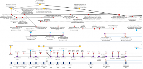
In this section, we illustrate the institutional changes and contestation between actors behind crucial development events over time, aiming to address some essential questions mentioned in the previous section. Below (Figure 1 and Figure 2) are the diagrams we used for our analysis to decipher details of institutional change, actors, and historical events in the megaproject. In the diagram, a straight line is drawn from the upper side of the diagram (institution point) to the bottom side (actors) to trace those who create or change institutions during specific events. Additionally, these events encompass the development activities or progresses in the megaproject that later determine the outcomes and impacts. Throughout the process depicted in the diagram, private sectors and governments can employ different means to further their interests and objectives through institutional design and change. The emergence of purple points (representing private sectors/developers) in the diagram, connected to other points (red for the provincial government, blue for central government or ministry, yellow for president, and green for the other parties), illustrates the interactions between supporting and opposing parties as they strive to preserve or challenge the existing institutions across different political periods.
The first critical juncture occurred during the initiation of NJBR project in 1995. Under the New Order era where neoliberal policies dominating the urban development model, Presidential Decree No. 52/1995 concerning Jakarta Bay Reclamation was issued. The presidential decree is considered as one of the path-dependent institutions designed in the megaproject development. As shown in the diagram, the institution indicates perpetual and long-term impacts several years later. For instance, after President Soeharto issued the presidential decree, Governor Soerjadi Soedirdja enacted Regional Regulation No. 8/1995 on Implementation of Reclamation and Spatial Area of North Jakarta Bay as well as undertook cooperation agreement with PT. Kapuk Naga Indah (a subsidiary of PT. Agung Sedayu Group), PT. Manggala Krida Yudha (Soeharto’s family business), and BPL Pluit. It also became the beginning of a phase in which developers are involved in the “formal” development process of the reclamation project. The institutional arrangements created in this early stage had directed and limited possible alternatives of decisions for the development in the future, even after the major structural changes took place. Thus, this marks the path-dependence of the future development.
Figure 1. Institutional change and actors of Megaproject: Jakarta Bay Reclamation Project 1995-2016
Figure 2. Institutional change and actors of Megaproject: Jakarta Bay Reclamation Project 2016-2018
However, path-dependent development pathways of megaproject can undergo instability if they are triggered by any exogenous shock or crisis, thus potentially opening new critical junctures in which the prevailing institution can be altered and new pathways are (re)shaped accordingly. There were at least two moments of exogenous shocks during the development of North Jakarta Bay Reclamation megaproject, i.e., monetary crisis (1997-1998) and natural disaster (2007) events that engendered the “near-miss” critical junctures. Although not reaching a radical level of institutional change, these moments generated “near-miss critical junctures”, in which renewed institutional arrangements resulted from various actors’ political struggles [33].
After the monetary crisis in 1997-1998, Indonesia underwent a political reform (entering the reform era). This moment pushed forward political restructuring towards a more democratic and decentralized governance. During the uncertain condition where political economy was restructured, idea contestation was widely opened. Moreover, as free press and media played more roles in public decision-making on large-scale projects in this era, diverse community-based organizations and environmental alliances competed to convey their ideas to challenge the inherited idea of market-oriented development. North Jakarta Bay Reclamation as one of the phenomenal projects initiated during the previous era was also at risk of being stopped. After reinitiated by the coalition of provincial government and developer, some “challengers” appeared to be opposing parties against the NJBR megaproject. Many NGOs, fishing communities, and some academicians highlighted the environmental and social impacts of the reclamation megaproject development that could worsen the degraded landscape. For example, the Ministry of Environment (MoE) argued the NJBR project was an impropriety under the Environmental Impact Assessment (EIA). This moment was followed by lawsuit and trial process in the Supreme Court between the government (MoE) and developers. The disputes continued until finally reaching the conclusion in a trial in 2011, where the Supreme Court decided that the developers won and that NJBR Project could legally be implemented.
On the other hand, the NJBR project was accommodated in the spatial plan of DKI Jakarta and Jakarta metropolitan area (Jabodetabek-Punjur) based on the previous presidential decrees, regulations, and cooperation agreements between the government and developers. In Presidential Regulation No. 54/2008 on Jabodetabek-Punjur Spatial Plan, it is mentioned that Presidential Decree No. 52/1995 on Jakarta Bay Reclamation is the legal basis for the reclamation project. In this phase, we can see that institutions designed in the previous New Order era were still able to limit any possible alternatives of undesirable actions from the opponent, thus social and environmental protests as well as political struggles against the megaproject development could be avoided. Besides, although there was a shift of power in the reform era, as the political economy had driven the government towards a more decentralized power, the power networks between the private sectors and the provincial/local governments became stronger.
The third “near-miss” critical juncture happened after a severe tidal flooding greatly affected Jakarta in 2007. This gave rise to various public discourses concerning the environmental issues in Jakarta that still struggled to deal with the problem of land subsidence and sinking city. In the midst of discourses to rethink of new institutional arrangements to overcome the disastrous flooding, Jakarta Coastal Defense Strategy (also known as Giant Sea Wall or National Capital Integrated Coastal Development) was proposed as a new strategic project. The project is located in the North Coast of Jakarta, and some parts of the area also overlaps with NJBR project site. As shown in several studies and documents, there were some alternatives considerations for NJBR project to be integrated with NCICD to create a comprehensive plan pertaining to flood control in Jakarta Bay as well as to expand the potential financing with public-private partnership scheme; although some actors argued that they were two completely different projects with different legal basis. However, from the proponents’ perspective, this strategy seemed to be used to defend the urgency of the NJBR project as part of environmental solution.
The Presidential Decree No. 52/1995 has brought some significant consequences in the future in terms of continuation of the megaproject. The presidential decree issued in the early stage of development subsequently became the rationale and reference for some regulations that were established after that. In other words, the presidential decree was the first critical juncture that marks the path dependence of the megaproject development. The black line on the diagram shows that the decree indirectly influenced the making of some regulations which solidified the legal certainty of the reclamation project at national and local level.
Besides being a consideration in spatial planning, the substance regarding the NJBR Project also has an impact in determining authority in the following years. For instance, an issue was lifted in 2014. The Minister of Maritime Affairs and Fisheries considered the issuance of a permit by the provincial government of DKI Jakarta as an unauthorized action because the permit cannot be carried out without her recommendation. As the Presidential Regulation No. 122/2012 on Reclamation in Coastal Area and Small Islands states, “the implementation permit of reclamation area in National Strategic Area must have a recommendation from the related minister” (article No.16). However, the Governor of DKI Jakarta at the time was persistent in stating that the reclamation project is provincial (governor’s) authority based on the Presidential Decree No. 52/1995 on Jakarta Bay Reclamation.
In general, the developers did not encounter major conflicting interests with the provincial government under several governors, except for the latest governor (period of 2017-2022). Some institutions were incrementally formed and changed by the provincial government to accelerate and sustain the development until 2017. Governor Fauzi Bowo accommodated the reclamation project into the Regional Regulation No. 1/2012 of Spatial Plan on DKI Jakarta and then enacted a specific regulation for the reclamation project, i.e., Governor Regulation no. 121/2012 on Spatial Planning of Reclamation Area in North Jakarta. Moreover, he also accelerated the issuance of development permits for the developers. At that time, President Susilo Bambang Yudhoyono (SBY) also issued the legal basis for reclamation by creating significant law and regulation regarding the reclamation development, e.g., Presidential Regulation No. 122/2012 on Reclamation in Coastal Area and Small Islands in Indonesia. In this period, both state and local governments build a good network to facilitate them creating and changing the institutions (rules, regulations, policies, agreements, etc.).
During Governor Ahok’s period, the coalition used the sudden emptiness that took place during the transition period from president SBY to Jokowi (the former governor of DKI Jakarta who became the president in 2014) to create or change institutions. As an acting governor under Jokowi, as well as the next governor, Ahok extended some principal permits, accelerated some implementation permits, and created regional regulation on zoning of reclamation and small islands in North Jakarta, as well as the spatial plan for strategic reclamation area. The transition period of provincial government has always been the moment where the institutional changes and creation occurs most frequently. At the end of Governor Ahok’s period, before his leave for the next election campaign, Regulation of the Governor of DKI Jakarta No. 206/2016 concerning Urban Design Guidelines for Islands C, D, and E was issued. Thereafter, before the transition to the new governor in 2017, Djarot Saiful Hidayat as the acting governor also enacted Regulation of the Governor of DKI Jakarta No. 137/2017 concerning Urban Design Guidelines for Island G. These two regulations became the legal basis for building permit issuance in the next period by Governor Anies, despite his political campaign promised to stop the reclamation project.
As depicted in the Figure 2, the issuance of Urban Design Guidelines (UDGL) for some of these islands was path-dependent and had an effect on the subsequent development phase. In the latest administration’s term, Governor Anies attempted to realize his political promise to stop reclamation activities through the revocation of principle and implementation permits for the 13 planned islands. However, the development of the other four islands, namely Islands C, D, G, and N is still allowed to continue based on the fulfillment of legal requirements and their current development progresses. The property developers of Island C - D, Island G, and Island N are PT Kapuk Naga Indah (a subsidiary of PT Agung Sedayu Group), PT Muara Wisesa Samudra (a subsidiary of PT Agung Podomoro Land), and State-Owned Enterprise Indonesian Harbor (Pelindo) II respectively. PT Kapuk Naga Indah already has permits and legal basis in the form of UDGL for Island C and Island D have been previously issued. Regarding the backfilling progress of the island reclamation, Island D has been fully filled in, while Island C is still halfway finished. Therefore, after completing the legal requirements and obtaining the building permit (IMB), they continue their progress. Some residential and commercial buildings have already been constructed and some others are currently under construction on Island C and Island D.
Although the permit for Island G was not revoked in the first place, the developer of Island G found an obstacle from the provincial government when applying for an extension of their expired permit in order to continue reclamation (backfilling) activities. The developer filed a lawsuit against the provincial government who refused to extend the permit, and the State Administrative Court granted the ruling. Eventually, despite the governor's request for a judicial review at the Supreme Court, the ruling remained unchanged. During the same period, the property developers of the other 13 islands filed lawsuits against the governor’s decree regarding the revocation of the licenses at the State Administrative Court. Despite the governor's appeal at the State Administrative High Court, most of the developers have still won the lawsuits. Thus far, the provincial government won the cassation regarding the reclamation permit for Island M among the 13 halted reclamation islands.
Political elections will be conducted soon, and there will be changes in the tenure period of government officials at various levels of government. Considering the historical circumstances, the future development of the NJBR project will continue to be influenced by the multi-level of government in office in the upcoming period. Currently, some reclamation islands, namely Island C, Island D, Island G, and Island N are already included in the current spatial plan in national and provincial level, i.e., Presidential Regulation No. 60/2020 on Spatial Plan of Jabodetabek-Punjur Urban Area and Governor Regulation No. 31/2022 on Detailed Spatial Plan of DKI Jakarta. Path dependence of the development trajectory will continue to shape and constrain the institutional design and development choices in the future.
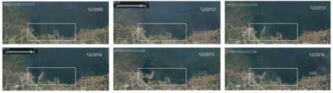
Figure 3. Progress of North Jakarta Bay Reclamation Project (NJBR) Development from 2000-2016
(Google Earth, 2022)
The institutional design and change from the beginning of the project until now have led to the current development trajectory. As shown in the Figure 3, up until this point, only two reclaimed islands (Island C and Island D) have been developed and built with residential and commercial buildings as well as public facilities on the areas. Moreover, Island D and Island C have also been connected with mainland of Jakarta and Tangerang (Banten province), respectively. The development progresses on those two islands have affected the construction progresses of the bridges connecting the Jakarta mainland to Island D, Island C, and subsequently to an inner-city part of Tangerang. The bridge from Island C is directly linked to another project owned by the same developer who developed Island C and Island D, in Tangerang.
Although the NJBR megaproject has not been fully implemented, the development paths (activities and progress) of the project, especially the development in Island C and Island D, have generated several outcomes and impacts. Development outcomes refer to the direct short to medium-term effects of project implementation [9, 34]. In this case, the development outcomes of the megaproject are primarily observed in Island C and D after their development and connection to the mainland of Jakarta. Path dependency has led to the result of expedited permits and a robust legal framework related to the development of the islands. Consequently, there has been relatively steady development and construction of buildings, infrastructure, and amenities, despite the current suspension of reclamation activities on the other planned islands. As a result, the developer of Island C and Island D has been able to commercialize the area and capture the market earlier than other private developers involved.
The most significant outcome of the area’s development is the land value gains, which are much higher than the development cost of land reclamation (amounts to approximately IDR 6,000,000 per square meter). Determining the market value of the land cannot solely rely on the average demand for land or price comparisons with surrounding areas due to the isolated nature of the reclaimed islands, separated from the mainland. However, the establishment of bridges connecting the reclaimed islands with mainland Jakarta has had a significant outcome on land value growth, in addition to the value increase resulting from the improved quality after infrastructure network and public facilities development. Consequently, the land values in Island D and Island C have become similar to the land value in the mainland of Jakarta, particularly in the Pantai Indah Kapuk (PIK 1) site in North Jakarta.
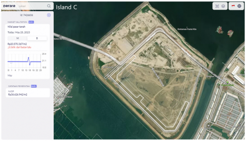
As depicted in Figure 4, the land value of residential property in Island D is approximately IDR 22,324,133 per square meter based on Perare (perare.io) data in 2023. This value is comparable to the land value in PIK 1 in North Jakarta, which ranges from IDR 21,000,000 to IDR 23,000,000 per square meter. Moreover, the land value of property in Island C has also shown a gradual increase, approaching the land values in Island D and PIK 1. As shown in Figure 5, the current land value in Island C is approximately IDR 20,570,367 per square meter based on Perare (perare.io) data in 2023. The developmental outcome resulted illustrates how complex institutional design and change over time give rise to specific pathways and outcomes within the megaproject.
Figure 4. The land market value and Sales Value of Taxable Object for Land/ NJOP on Island D (perare.io, 2023)
Figure 5. The land market value and Sales Value of Taxable Object for Land/ NJOP on Island C (perare.io, 2023)
4.2 Extending institutional path dependency beyond the Megaproject: Development impacts on interconnected urban spaces
Besides producing development outcomes, the development of the NJBR megaproject has also had impacts on a larger spatial scale. Development impacts encompass the direct or indirect long-term effects of project implementation, not only on the specific project site but also on broader scales including the surrounding environment and even the urban structure [9, 34]. As shown in Figure 6, we can observe the impacts of the NJBR megaproject on another specific project site located in a different administrative area, namely Pantai Indah Kapuk (PIK) 2, and on larger urban structures.
We elaborate on how the megaproject generated development impacts through several processes. Firstly, path dependency from the institutional arrangement and development paths in the NJBR megaproject has influenced development in PIK 2. Secondly, the development impacts begin to emerge in another project site (PIK 2). Thirdly, the institutional arrangement and development paths shaped in these two interrelated projects then have wider impacts on institutional development in urban structures.
Figure 6. Area of North Jakarta Bay Reclamation Project (NJBR) and Pantai Indah Kapuk 2 (Google Earth, 2022)
First, related to how path dependency from the NJBR megaproject has influenced another project site, we discuss the connection between NJBR project in North Jakarta City, DKI Jakarta Province and another urban project of Pantai Indah Kapuk (PIK) 2 in Tangerang Regency, Banten Province, located in the western part of Jakarta. As a background, PIK 2 is a private developer’s new town project that involves various modern property development such as large-scale residential housing, offices, and commercial skyscrapers and town facilities developed. PIK 2 project is developed by the same company who developed Island C and D (also the undeveloped Island A, B, E) of NJBR project, PT Agung Sedayu Group. In developing this project, they created a partnership with Salim Group, the other major enterprise in Indonesia.
As depicted in Figure 7 below, the regent of Tangerang enacted Regional Regulation Number 8 of 2006 containing the plan for New Town Development Areas in Tangerang Regency. Furthermore, National Spatial Planning Coordinating Agency (BKPRN) issued the permit related to land reclamation in the North Coast of Tangerang in 2010 for the local government of Tangerang. In 2011, the local government also gave the detailed location of the reclamation in Local Regulation No 13/2011 on Spatial Planning of Tangerang. It is stated in article 56 that “The reclamation area ... is intended as an urban residential area, integrated port area and industrial area in the northern part of the seawaters, with an area of approximately 9,000 (nine thousand) hectares, a distance of approximately 200 (two hundred) meters from the shoreline towards the sea”. The reclamation is planned to take place in Kosambi (where the current development of PIK 2 is located), Teluknaga, Pakuhaji, Sukadiri, Mauk, Kemiri, and Kronjo district. From 2013 to 2015, various regulations and decree related to revitalization of slum areas located in the planned new town development areas, particularly in Dadap (Kosambi District, Tangerang), were enacted by the local government.
As mentioned in the previous section, the project proponent involved in the NJBR megaproject attempted to strengthen the legal basis and accelerate the development permit for the reclamation islands from 2008 to 2015. Meanwhile, from 2011 to 2015, the PIK 2 project realized the early phase of development by acquiring over 1,000 hectares of land (from the total area of 2.650 hectares) and clearing sites on the North Coast of Tangerang City. Moreover, infrastructure construction permits to build bridges connecting PIK 1, Island D, Island C, and PIK 2 sites were also arranged during the period. Eventually, the connecting bridge between Island D and PIK 1 in North Jakarta has been built and operational since 2018, while the connecting bridge between Island C and PIK 2 has been ready in 2020. The path dependency evolved from institutional design in each project has ultimately resulted in coherent processes in the timing and sequence of development events, leading to the development path of two reclaimed islands from the NJBR project (Island C and Island D), PIK 1 in North Jakarta City, and PIK 2 in Tangerang Regency as an integrated large-scale land development. Consequently, these development paths also produce long-term impacts.
The long-term development path in the NJBR megaproject, inherently interconnected with another site, has also generated impacts on the specific site, PIK 2, and its surroundings. Up to the present time, the most apparent impacts resulted from the ‘integration’ between the two interrelated project spaces are seen in the economic aspect, particularly in relation to real estate and property market. Initially, most of the parts of the PIK 2 project were developed on vacant land on the North Coast of Tangerang. Prior to the development, there was no direct infrastructure network connecting the site to other urban centers in Tangerang or Jakarta. To improve accessibility, the developer has planned to connect the project site with new road developments and integrate it with the public transportation in the metropolitan area on the mainland. However, even before these plans are realized, the market value of land and properties in the project has already experienced a significant increase because the project site has been connected with the NJBR project site through the bridge development.
Figure 7. Institutional arrangement related to reclamation and new town development in the North Coast of Tangerang
Figure 8. The land market value and Sales Value of Taxable Object for Land/ NJOP in PIK 2 (perare.io, 2023)
The developer of PIK 2 highlights the excellent accessibility of the project, as it is connected to Island C and Island D (NJBR project) and PIK 1 area (Jakarta mainland) via bridges. This allows the area to be reached from PIK 1 (Jakarta) in just 5-10 minutes by driving. Sense of exclusiveness is also created because the wide network of bridges and roads connects elite areas, in contrast to the experience of navigating narrow and congested neighborhood streets in the previous route. In this case, the land reclamation (NJBR project) serves as a crucial ‘median’ for connecting two project sites between North Jakarta and Tangerang. By establishing such physical connections through infrastructure, the overall land value in the PIK 2 project has significantly increased, transforming the originally isolated site into a thriving area.
As shown in Figure 8, the land value of residential property in one of the most premium clusters in PIK 2 reaches IDR 29,960,377 per square meter based on Perare (perare.io) data in May 2023. The average land value of residential properties in this area ranges approximately from IDR 20,000,000 to IDR 30,000,000. However, as the project is advancing rapidly, the Sales Value of Taxable Object for Land (NJOP tanah) in this area has not been adjusted to the current land market value, which has significantly increased in the last few years. The latest Sales Value of Taxable Object for Land (NJOP tanah) mentioned in Figure 8 still represents the latest average land value prior to the development progresses of the PIK 2 project.
Figure 9. Land value in 2015 & 2020 (Ministry of Agrarian Affairs and Spatial Planning/National Land Agency, 2015 and 2020)
Furthermore, to investigate how land values change before, during, and after the NJBR and PIK 2 projects development, we used set of historical data. As a reference for determining value of NJOP tanah, historical data of Land Value Zone (ZNT) can indicate the changes in land value over time, despite the limitations stated in the methodology section. We also utilized several historical datasets of land values, based on surveys conducted at various periods by the Ministry of Agrarian and Spatial Planning/National Land Agency (see Figure 9), in addition to the latest version of ZNT data published on the website (see Figure 10). These historical datasets were also used as the basis for determining the ZNT data for the relevant year.
Figure 10. Land Value Zone/ ZNT in 2023 (Ministry of Agrarian Affairs and Spatial Planning/National Land Agency, 2023)
By examining historical data of land values on a wider scale, we can investigate both the increase in land value and the extent to which the development projects affect land values within the areas compared to the natural growth of each region. As shown in Figure 9, in 2015, there were considerable discrepancies in land values between the PIK 1 area and its surrounding areas, particularly in the western part along the North Coast of Jakarta and Tangerang. Alongside the NJBR and PIK 2 projects, which continue to progress, feature improved access and interconnectivity between project areas, land values in these areas have been continuously increasing up to the present moment.
As depicted in Figure 9, land value data in the areas of NJBR megaproject (Island C and Island D) had not been explicitly defined until 2020, as the project is located separately from the mainland. Then, in 2023, land value in the project was identified as greater than IDR 20,000,000 per square meter, similar to the average land value in PIK 1 (Figure 10). As previously shown, building construction has been underway since 2016, and the connecting bridge between Island D and PIK 1 in mainland Jakarta has been built and operational since 2018. The decision to continue reclamation on these two islands has also strengthened legal certainty regarding the development, which has subsequently influenced the market value up to the present time.
On the other hand, as seen in Figure 9, the average land value in PIK 2 project slightly increased between 2015 and 2020, from approximately IDR 200,000 – 500,000 to IDR 500,000 – 1,000,000. During this period, the developer executed marketing activities with higher offering prices than the surrounding area's land values, driven by promising accessibility from the integrated infrastructure networks and planned high-class facilities. The realization of the plan was finally fulfilled in 2020 when the PIK 2 project was connected to the NJBR project and the PIK 1 area (Jakarta mainland) through the development of bridges, along with the development of commercial areas, residential areas, and high-quality amenities. In 2023, land and property prices continue to rise as ongoing and long-term development progresses smoothly. However, the actual market value is better reflected in Figure 8 rather than Figure 10. Based on the ZNT data in 2023 (Figure 10), PIK 2 and its surrounding areas overlap with three Land Value Zones (ZNT) with the highest value at IDR 2,000,000 per square meter in 2023. The Land Value Zone (ZNT) does not represent the current value, which can actually reach IDR 30,000,000 per square meter.
As land value is a key component of real estate and property markets, changes in land value can have significant economic implications. A rise in the market demand for real estate and property, indicated by the increase in land value, has several positive and negative economic effects. An increase in land value can directly generate more tax revenue for the government and provide additional funds for public infrastructure. In the long term, the increase of land value can potentially attract investment and stimulate new development projects in the areas. On the other hand, higher land and property prices can also have externalities that need to be anticipated in the future, such as a lack of affordable properties, gentrification, and spatial segregation among different socio-economic statuses in the area.
As the projects continue to unfold, the transformation of these areas has not only influenced the economic condition from the increased land value, but has also had far-reaching effects on the local communities and the surrounding natural environment. While the current economic implications are evident, there are still social and environmental impacts that need to be anticipated as the projects progress. One of the crucial issues is the potential impact on existing fishing villages along the coastal area in relation to the development of the reclaimed islands, particularly if all planned reclamation islands are developed in the future. These changes could significantly affect the way of life and well-being of the local fishing communities, making it essential to carefully consider and mitigate the effects on their livelihoods.
Furthermore, there is also a growing awareness and public focus on environmental issues in the region, such as flooding, land subsidence, sea level rise, and marine pollution along the coastal area. These concerns have sparked public discussions surrounding the ongoing "sinking Jakarta" crisis. Addressing environmental challenges and ensuring their sustainability is crucial. This requires careful consideration of the potential impacts that ongoing and future development may have on local communities and ecosystems in the long-term. Finally, the impacts of a megaproject should not be assessed solely within the boundaries of the project site; instead, they should be considered in a broader context that includes external and interconnected areas. As our findings highlight, the impacts observed in PIK 2 can be attributed to the path dependency originating from the NJBR megaproject's institutional arrangement and development trajectory. Particularly striking is the economic impact of the increased land value witnessed in PIK 2, which underscores the broader consequences of institutional path dependency from the NJBR megaproject.
Lastly, path-dependent institution and development path shaped in the two interrelated projects (NJBR and PIK 2 projects) then generate wider impacts on institutional development in urban structures at the local and regional/metropolitan scales. In the broader context, many actors from multiple levels of government have involved in institutional design and change that bring consequences across spatial units and scales. At the local scale, the coherent processes in timing and sequence of institutional development were observed in North Jakarta, DKI Jakarta and Tangerang, Banten during the efforts to establish the legal basis for development activities in the two projects. Institutional design and change of regulations, rules, and policies in the two cities related to spatial plan, (construction) permit for land, property, and infrastructure (i.e., bridges and roads network development), and revitalization program were synchronized and occurred in the desired sequence based on the development stages in the projects.
Furthermore, the path-dependent institution of the two projects also has impacts on the regional scale, specifically the metropolitan area of Jabodetabek-Punjur. There are several issues, particularly related to spatial planning and infrastructure development that needs coordination across provincial jurisdiction. There were some related regulations in the national government level that accommodate plans for the two projects, e.g., Presidential Regulation No. 60/2020 on Spatial Plan of Jakarta, Bogor, Depok, Tangerang, Bekasi, Puncak, and Cianjur (Jabodetabek-Punjur) Urban Area and Presidential Regulation No. 55/2018 on Transportation Master Plan of Jakarta, Bogor, Depok, Tangerang and Bekasi (Jabodetabek). In the Presidential Regulation No. 60/2020, it is stated that the reclamation islands of NJBR megaprojects, namely Island C, D, G, and N in the North Coast of Jabodetabek-Punjur urban area are Zone B8, which are designated for residential use and their supporting facilities, commercial and service use, warehousing and industrial use, power generation centers, and tourism use.
In line with this, infrastructure networks and transportation connections between the site and other urban areas at the metropolitan level are also included in Presidential Regulation No. 55/2018. The regulation includes a plan for the construction of the JORR II Kamal - Teluk Naga - Rajeg Toll Road in 2025-2029, which is part of the northern ring road. The planned toll road will be connected to the Prof. Dr. Sedyatmo Toll Road, which connects DKI Jakarta with Soekarno-Hatta International Airport. This connection will provide direct access from PIK 2 to the Soekarno Hatta Airport area and DKI Jakarta. Additionally, the regulation also mentions the Tangerang Ring LRT (Soekarno-Hatta Airport – Alam Sutera – BSD City – Summarecon/Paramount – Lippo Karawaci – Citra Raya – Suvarna Padi Cikupa – Teluk Naga/Kosambi North Coast Area (PIK 2) – Soekarno Hatta Airport) in 2025-2029. With the toll road and LRT road plans outlined in the Transportation Master Plan of Jabodetabek, there will be an increase in connectivity between the project area and other urban centers in the Jakarta metropolitan area.
As areas developing various commercial centers, tourism amenities, and urban facilities, these developments will potentially affect the mobility of people in the Jakarta (Jabodetabek-Punjur) Metropolitan Area, leading to enhanced regional accessibility. In the long term, the established institutions, particularly the spatial plan and the transportation master plan accommodating the development, potentially have impacts on the urban structure in metropolitan area of Jabodetabek-Punjur. This finding also emphasizes that the long-term development impacts resulting from institutional path dependency within a megaproject can extend to a broader scale.
By adopting Historical Institutionalism framework in an urban megaproject, we uncovered some key findings related to how megaproject institution produces path-dependency process that has distributional effects over the long-term. The results show that institutional design of the megaproject has locked the development trajectories for both the megaproject site and another urban space in different region several years later. The transformational impacts pertaining to physical, economic, and environmental conditions in another urban space are not directly generated by the creation of megaprojects, as shown in the current literatures [1, 5, 8, 9]. Rather, they are the results of path-dependency and consequences from the institutional restructuring during the megaproject development process. Thus, both institutions and socio-spatial urban changes are interdependent and shape the patterns of development over time. By utilizing institutional perspective on urban megaproject planning and development, this study enriches the understanding on the contemporary theorization of the urban megaproject development impacts.
Path-dependency has resulted in expedited permits and a legal framework that allows the development and construction to continue on certain reclaimed islands in NJBR megaproject, despite the suspension of reclamation activities (on the other planned islands) by the latest administration’s term. As a result, the development paths, particularly in Island C and Island D of the NJBR megaproject, have generated several outcomes and impacts. The developer of the reclaimed islands gains an advantage in commercializing the area and capturing the market earlier than other private developers. One of the most significant outcomes of the development is the increase in land value, which is influenced not only by the improved quality of the built environment but also by the connection of the reclaimed islands with mainland Jakarta (PIK 1 area) through the bridge infrastructure development.
Furthermore, the long-term impacts of the NJBR megaproject extend to another project site called Pantai Indah Kapuk (PIK) 2 and have effects on larger urban structures at the local and regional scales. The institutional arrangement and development paths created in the NJBR megaproject has influenced institutional development in PIK 2. This has resulted in coherent processes and timing of development events, integrating Island C and Island D and PIK 2 into a large-scale land development. The market value of land and properties in the PIK 2 project has also significantly increased due to the connection with the NJBR project through the bridge development. This subsequently has economic impacts on the increase of tax revenue and potential investment from the new projects in the future, but also potential externalities such as gentrification and spatial segregation that need to be anticipated. Moreover, several institutions at the local and regional (metropolitan) scales were changed during the efforts to establish the legal basis for development activities in the two projects. The established institutions potentially have impacts in determining alternatives for development paths, particularly related to property and infrastructure development, that can affect the urban structure in metropolitan area of Jabodetabek-Punjur in the future.
This paper depicts The North Jakarta Bay Reclamation (NJBR) as an urban megaproject that has a long-term and a complex process of planning and development. Institutional development of this project was contested by various interests of actors, especially when critical juncture (exogenous change) moment occurred. Despite various exogenous changes such as changing political regimes and environmental conditions, actors in the megaproject coalition, especially dominant public and private stakeholders, can adapt and maintain expected outcomes within prevailing institutions. They effectively build and change institutions that constrain alternatives in their favor to influence short-term development outcomes and long-term impacts. Some gradual changes of institutions (renewed, revised, extended regulations) also signify that several groups expect specific outcomes. For those who agreed to continue the reclamation, acceleration of regulations as well as development permits was important to increase the legal certainty.
In terms of governance, the path-dependent institution established since almost three decades ago has significant impacts on how actors create rules of the game in managing public infrastructure and coordinating the activities of the private sectors, particularly in land and property development. Moreover, it also influences the way the involved actors mitigate the economic, social, political, and environmental impacts on a larger scale. As shown in the case study, private actors have power to realize their interests and objectives in the processes of institutional design and change. In Jakarta, such pattern occurred since decades ago because of the limited knowledge and innovation of local government compared to the private sector, particularly the property developer [35]. Such activity becomes a main challenge to local governments of Jakarta City and Tangerang City. Finally, as urban megaproject becomes a future development trend, understanding the implications of institutional design and change of megaproject is important for the governments (especially the local government) to allocate resources and anticipate negative externalities of megaproject development.
Learning from the NJBR project case, there are several common practices upon which to reflect. Firstly, the involved stakeholders, especially governments, must thoroughly understand the prevailing institutions, including the historical context when they were established. Furthermore, they need to understand that creating or changing institutions during critical moments may lead to lasting and far-reaching consequences in the future. Second, politicians and government actors often use decisions related to megaproject, whether to endorse or turn down the project, as a policy signature during election. However, because certain institutions are path-dependent, challenging them with a new decision could be difficult, and the realization of such a political promise might be hindered.
Third, megaproject is frequently constructed for legacy purpose, with established institutions prioritizing these objectives over technical and rational considerations, often resulting in delays and budget overruns. Lastly, megaproject impacts can extend beyond their immediate sites, affecting urban structures and regions. Coordination among actors at various spatial scales, spanning provincial jurisdictions, is essential to measure and mitigate the potential large-scale impacts. Spatial planning and infrastructure development in Jabodetabek-Punjur Metropolitan Area have already incorporated plans to improve connectivity between the strategic megaprojects, with ongoing extensions. Therefore, institutional designs should be prepared to address the significant impact they may generate on a regional scale.
This paper focuses on investigating the economic impact resulting from land, property and infrastructure development due to institutional path dependency of megaprojects. However, future research should explore more about the other impacts, e.g., social and environmental impacts, associated with institutional path dependency. These impacts may exhibit distinct characteristics with the economic impact in terms of causality and a longer time frame for impacts to become evident. Thus, examining how institutions influence social and environmental outcomes within the megaproject framework will shed light on the broader implications of institutional path-dependency.
Moreover, it is crucial to delve deeper into the dynamics that underlie institutional change, treating it as a reflection of power dynamics within the context of institutional path dependency and its impacts on megaprojects. Analyzing the diverse interests and strategies of stakeholders, ranging from government agencies to private sector partners and local communities, will provide invaluable insights into how these dynamics shape decision-making processes and project outcomes.
[1] Del Cerro Santamaria, G. (2019). Megaprojects, development and competitiveness: Building the infrastructure for globalization and neoliberalism. Athens Journal of Social Sciences, 6(4): 263-290. https://doi.org/10.30958/ajss.6-4-1
[2] Clegg, S.R., Sankaran, S., Biesenthal, C., Pollack, J. (2017). Power and sensemaking in megaprojects. The Oxford Handbook of Megaproject Management, 238-258.
[3] Flyvbjerg, B. (2014). What you should know about megaprojects and why: An overview. Project Management Journal, 45(2): 6-19. https://doi.org/10.1002/pmj.21409
[4] Scott, W.R., Levitt, R.E. (2017). Institutional Challenges and Solutions for Megaprojects. The Oxford Handbook of Megaproject Management, Oxford, Oxford University Press, pp. 96-117. https://doi.org/10.1093/oxfordhb/9780198732242.013.4
[5] Hanakata, N.C., Gasco, A. (2018). The Grand Projet politics of an urban age: Urban megaprojects in Asia and Europe. Palgrave Communications, 4(1): 1-10. https://doi.org/10.1057/s41599-018-0141-5
[6] Lehtonen, M. (2014). Evaluating megaprojects: From the ‘iron triangle’to network mapping. Evaluation, 20(3): 278-295. https://doi.org/10.1177/1356389014539868
[7] Kheyroddin, R., Bahremand, M.O. (2017). The impact of urban mega-project on housing price in adjacent neighborhoods (Case study: Sadr Multi-layered Highway, Tehran). Journal of Urban Economics and Management, 5(17): 13-29.
[8] Ryu, C., Kwon, Y. (2016). How do mega projects alter the city to be more sustainable? Spatial changes following the Seoul Cheonggyecheon Restoration Project in South Korea. Sustainability, 8(11): 1178. https://doi.org/10.3390/su8111178
[9] Dogan, E., Stupar, A. (2017). The limits of growth: A case study of three mega-projects in Istanbul. Cities, 60: 281-288. https://doi.org/10.1016/j.cities.2016.09.013
[10] Alberti, J. (2019). The Institutional Environment of Megaproject Planning and Appraisal (Vol. 702). Inter-American Development Bank. https://doi.org/10.18235/0001779
[11] Gellert, P.K., Lynch, B.D. (2003). Mega-projects as displacements. International Social Science Journal, 55(175): 15-25. https://doi.org/10.1111/1468-2451.5501002
[12] Banister, D., Berechman, Y. (2001). Transport investment and the promotion of economic growth. Journal of Transport Geography, 9(3): 209-218. https://doi.org/10.1016/S0966-6923(01)00013-8
[13] Colomer, J.M. (2008). Institutional Design. Handbook of Comparative Politics., Thousand Oaks, CA, Sage, pp. 246-262.
[14] Sorensen, A. (2018). Institutions and urban space: Land, infrastructure, and governance in the production of urban property. Planning Theory & Practice, 19(1): 21-38. https://doi.org/10.1080/14649357.2017.1408136
[15] Thelen, K. (1999). Historical institutionalism in comparative politics. Annual Review of Political Science, 2(1): 369-404. http://doi.org/10.1146/annurev.polisci.2.1.369
[16] Bell, S. (2002). Institutionalism: Old and New. Government, Politics, Power and Policy in Australia, NSW Australia, Pearson Education Australia, pp. 363-380.
[17] Garud, R., Hardy, C., Maguire, S. (2007). Institutional entrepreneurship as embedded agency: An introduction to the special issue. Organization studies, 28(7): 957-969. https://doi.org/10.1177/0170840607078958
[18] Swyngedouw, E., Moulaert, F., Rodriguez, A. (2002). Neoliberal urbanization in Europe: Large–scale urban development projects and the new urban policy. Antipode, 34(3): 542-577. https://doi.org/10.1111/1467-8330.00254
[19] Lehrer, U., Laidley, J. (2008). Old mega-projects newly packaged? Waterfront redevelopment in Toronto. International Journal of Urban and Regional Research, 32(4): 786-803. https://doi.org/10.1111/j.1468-2427.2008.00830.x
[20] Fainstein, S.S. (2008). Mega-projects in New York, London and Amsterdam. International Journal of Urban and Regional Research, 32(4): 768-785. https://doi.org/10.1111/j.1468-2427.2008.00826.x
[21] Kennedy, L. (2015). The politics and changing paradigm of megaproject development in metropolitan cities. Habitat International, 45: 163-168. https://doi.org/10.1016/j.habitatint.2014.07.001
[22] Hudalah, D., Talitha, T., Lestari, S.F. (2022). Pragmatic state rescaling: The dynamics and diversity of state space in Indonesian megaproject planning and governance. Environment and Planning C: Politics and Space, 40(2): 481-501. https://doi.org/10.1177/23996544211030935
[23] Flyvbjerg, B., Bruzelius, N., Rothengatter, W. (2003). Megaprojects and Risk: An Anatomy of Ambition, Cambridge: Cambridge University Press.
[24] Salet, W. (2008). Rethinking urban projects: Experiences in Europe. Urban Studies, 45(11): 2343-2363. https://doi.org/10.1177/0042098008095871
[25] Aaltonen, K., Kujala, J. (2010). A project lifecycle perspective on stakeholder influence strategies in global projects. Scandinavian Journal of Management, 26(4): 381-397. https://doi.org/10.1016/j.scaman.2010.09.001
[26] Healey, P. (2007). Models of the development process: A review. Journal of Property Research, 8(3): 219-238. https://doi.org/10.1080/09599919108724039
[27] Winarso, H. (2000). Residential land developers' behaviour in Jabotabek, Indonesia. Doctoral dissertation, University of London, University College London (United Kingdom).
[28] Fioretos, O., Falleti, T.G., Sheingate, A. (2016). Historical Institutionalism in Political Science. The Oxford Handbook of Historical Institutionalism, Oxford, Oxford University Press, pp. 3-28. https://doi.org/10.1093/oxfordhb/9780199662814.013.1
[29] Sorensen, A. (2015). Taking path dependence seriously: An historical institutionalist research agenda in planning history. Planning Perspectives, 30(1): 17-38. https://doi.org/10.1080/02665433.2013.874299
[30] Mahoney, J., Mohamedali, K., Nguyen, C. (2016). Causality and Time in Historical Institutionalism. The Oxford Handbook of Historical Institutionalism, Oxford, Oxford University Press, pp. 71-88.
[31] Capoccia, G., Kelemen, R.D. (2007). The study of critical junctures: Theory, narrative, and counterfactuals in historical institutionalism. World Politics, 59(3): 341-369. https://doi.org/10.1017/S0043887100020852
[32] Pierson, P. (2016). Power in Historical Institutionalism. The Oxford Handbook of Historical Institutionalism, Oxford, Oxford University Press, pp. 124-141.
[33] Capoccia, G. (2015). Critical junctures and institutional change. Advances in Comparative-Historical Analysis, 147-179. https://doi.org/10.1017/CBO9781316273104.007
[34] OECD. (2007). Glossary of key terms in evaluation and results based management. Sida, Stockholm. https://www.oecd.org/dac/evaluation/dcdndep/39249691.pdf.
[35] Herlambang, S., Leitner, H., Tjung, L.J., Sheppard, E., Anguelov, D. (2019). Jakarta’s great land transformation: Hybrid neoliberalisation and informality. Urban Studies, 56(4): 627-648. https://doi.org/10.1177/0042098018756556