Primantoro Nur Vitrianto![]()
© 2023 IIETA. This article is published by IIETA and is licensed under the CC BY 4.0 license (http://creativecommons.org/licenses/by/4.0/).
OPEN ACCESS
The development of geoparks and tourism activities can significantly alter the spatial elements within a geopark. This study examines changes in spatial elements at Nglanggeran Ancient Volcano within the Gunung Sewu-UNESCO Global Geopark, caused by geopark development and tourism. Using a descriptive qualitative approach with a spatial element analysis, the study finds that the process of spatial change is influenced by non-fixed elements, with differences in the process due to variations in tourism and geopark development activities. The study identifies external factors, such as tourism, as key drivers of spatial changes. The findings highlight the potential for tourism to increase income through the development of tourism service businesses. The study contributes to advancing knowledge of the relationship between geopark development, tourism, and spatial changes, and offers insights for the sustainable development of geoparks and tourism in the future.
geopark, Gunung Sewu, Nglanggeran, space change, space elements, tourism
The space in an area and the activities that arise in it influence each other. Space changes are also triggered by the dynamics that occur in the elements within it. Not only in tourism spaces, various factors also influence space changes in a geopark. This study's factors influencing changes in tourism include tourism phenomena, experiences, tourism characteristics, tourism product services, and support and linkages between actors (community, government, private). These factors are suspected of impacting the dynamics of existing spatial elements. These indicators will examine space changes, especially at Nglanggeran Geosite, Gunung Sewu Yogyakarta - UNESCO Global Geopark.
Nglanggeran Ancient Volcano Geosite is located in Nglanggeran Village, Patuk District, and functions as a particular area of interest for ancient volcano geotourism. Before becoming a tourist destination, the Nglanggeran Ancient Volcano area was just a village with economic activities in farming and rice fields in a large rocky area or rocky mountain. Visits from outside communities to this area were mainly aimed at conducting earth research on the existence of ancient volcanoes. Visits continued to increase, especially after the earthquake in Bantul that also affected the area, which eventually raised the issue that Nglanggeran mountain would erupt due to the earthquake.
Tourism has a significant impact on the development of tourism spaces and areas. Geopark-based tourism or geotourism is defined as tourism focusing on geological and landscape attractions as a magnet for tourists closely related to earth, culture, and ecotourism. These activities aim to preserve geoheritage resources, empower communities, promote geological heritage, and establish cross-sectoral cooperation. Andriani and Pitana [1] explain that tourism is an activity related to industry and services prioritized or a mainstay commodity for Indonesia to increase state revenue or income [2]. Earth tourism attraction in a geopark that is developed sustainably becomes a tool for empowering local and regional communities. Geopark or earth park is a new concept in tourism developed by the Ministry of Tourism, and UNESCO introduced this concept in the 2000s. In its concept, a geopark is expected to preserve nature and improve people's lives. Geopark is a concept created to conserve an area based on unique geology [3]. In addition, a geopark is also expected to develop sites in terms of economic improvement and community empowerment.
The utilization of the earth's potential in an area can be carried out using a geotourism approach. Geotourism is a new paradigm that utilizes an area's geological and geomorphological potential while considering environmental conservation and community welfare. Geotourism develops effectively in areas formed for this purpose, often called geoparks. The development of a geopark will undoubtedly adjust to the needs of tourists. Spatial changes to a geopark continue to occur slowly and take place continuously. Changes take place slowly and continuously over a relatively long time. The development of tourism also influences the change in space in the area. Semi-fixed space elements are the elements that change the most and determine the structure of tourism space. The dynamics of tourism activities as non-fixed elements greatly influence the development of semi-fixed elements [4].
This research was conducted to determine how the process of changing spatial elements in the geopark area occurs. The development of tourism activities and geopark development activities can influence the elements of space. This research was conducted based on the rapid development of spatial changes that occur in the geopark. Space changes are in the form of changes in functions and activities in the geopark area, such as the growth of various commercial functions, such as stalls and parking, in line with the development of tourism activities in the region.
2.1 Space
In human life, space is a crucial component intimately tied to time. Space is "a container that comprises land space, sea space, and air space, as well as space within the planet as a cohesive region where humans and other organisms dwell, conduct activities, and survive" [5]. The growth of tourism in a region promotes the establishment of tourist space. Tourist space is a geographical and socio-economic region, including tourism phenomena [6]. As a living place, tourism space is formed of material and social components for those who live in it, with the notion of tourism as a multifaceted worldwide experience [7]. Tourism space can be formed based on tourism characteristics and the ongoing tourism product services that are distributed and enjoyed [6].
According to Rapoport [8], the heritage area is divided into three types of elements: permanent elements, semi-fixed elements, and non-fixed components. Cities, structures, and ruins are examples of fixed features that are regular and organized and do not change quickly, seldom, or slowly. Semi-fixed components like plants and furniture can be moved relatively quickly. A similar approach was taken by Wijaya [9], who used a spatial element approach to examine the phenomenon of banyan space concerning ritual and secular values in Bali. The individuals who live in the region are non-fixed elements. Land use change is defined as the increase of land use from one end of the land use spectrum to the other, with a decline in other forms of land use through time or land use change induced by time [10].
2.2 Tourism
Tourism is all related to tourism and has a multidisciplinary and multidimensional nature [11]. Tourism is an action taken by tourists on vacation out of everyday life for a temporary escape from daily activities, which is caused by a need without expecting compensation, getting pleasure, and enjoying various entertainment that can reduce fatigue and travel experience [12]. Tourism development in the Nglanggeran geosite is limited to nature and cultural tourism. Nature tourism is a tourist activity carried out with the main attraction of natural landscape conditions [11]. Cultural tourism is a travel activity by tourists to watch or enjoy archaeological sites, historical sites, museums, traditional ceremonies, religious ceremonies, art performances, festivals, and so on [13].
Tourism destination is also a notion that customers might perceive subjectively regarding travel, culture, purpose of visit, education, and previous experience [14]. Tourism destinations may be described as an integrated design of infrastructural amenities to fulfill visitor demands [15]. Tourist attractions have four key components: attraction, accessibility, amenity, additional service, and institution. Tourism drives potential local growth, helping close the gap with other places with comparable resources. This qualifies tourism as a leading industry capable of supporting the area's economy.
2.3 Geopark
Geopark is areas designed to safeguard and improve natural heritage functions such as distinctive geology (excellent geology), ecology, archaeology, and culture, and they incorporate the community [16]. The potential for earth tourism in the Sewu Mountain area is vast; one method of utilizing earth tourism in this location is to create a geotourism model in a specific area known as a geopark. Geopark is a concept of long-term development in a region with a unique geoheritage of worldwide significance [17]. Keever and Zouros [18] explain that geotourism and geopark provide sustainability principles that can increase the positive impact of the local economy by increasing the number of tourist visits and play an essential role in local economic development. The characteristics of UNESCO Global Geopark, according to Komoo [19], are:
Humans are one of the research instruments in qualitative research methodologies; by highlighting humans as research instruments, the realities in the field will become clearer [20]. Qualitative research, as a tradition in the social sciences, relies on observing human beings in their settings and relating to them in their language and terms [21]. Human activities strongly influence the phenomenon of spatial change in a geopark. The existence of human activity serves as the foundation for this qualitative study.
The phenomena of changes in spatial features that occur at Nglanggeran Geosite, Gunung Sewu Yogyakarta - UNESCO Global Geopark, are investigated in this study. The researcher conducts exploratory approaches such as observation and in-depth interviews to notice changes in spatial features. In-depth interviews were conducted in this study by selecting key people or main actors as the object of the interviews. The interviews were conducted by emphasizing the deepening of the spatial process and the ongoing development of tourism. Informants in this research include the Tourism Office, geosite managers, local government, tourism business actors, and also the people who live in or around the geosite.
Applying these tools will expose all tourist and geopark development activities in the research location. This study also uses secondary data in the form of land use maps. This study employs Rapoport's space element method in the form of space-forming elements, namely fixed, semi-fixed, and non-fixed elements, to examine the elements in the Nglanggeran geosite area space [22-24]. Modification of Rapoport's space elements to adapt conditions to contextual conditions in the field in the form of Table 1:
Table 1. Parameter Analisis Elemen Ruang
|
Space Element |
Indicator |
|
Fixed Element |
|
|
Semi-Fixed Element |
|
|
Non-Fixed Element |
|
Source: adaptation from [22-24]
As the primary commodity, tourism has an essential role as a driver of regional economic growth. The tourism multiplier effect affects the development and movement of other industries, such as the service industry. Potential tourist attractions in nature tourism, such as beaches, forests, mountains, and other natural features, such as karst areas stretch in Nglanggeran Geosite, Gunung Sewu Yogyakarta - UNESCO Global Geopark. The beauty, for example, is the remnants of ancient volcanoes that stretch across the area.
Geopark development is also related to various policies carried out by geopark managers. The policies will be related to preservation, community empowerment, and economic improvement. The policies formulated by Gunung Sewu Geopark, as described by Samodra [25], are in the form of geopark sustainable development policies related to the organization of geo-heritage, geo-education, and geotourism.
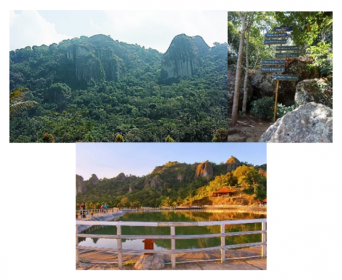
Nglanggeran is a geosite with potential natural tourist attractions in the form of an Ancient Volcano and developed as a tourist village. The geological site was formed by a volcanic eruption 15 million years ago. This geosite also has an artificial embung (pond) located on a hill, which functions as irrigation for fruit gardens (one of which is non-cholesterol durian) which is an agro-tourism attraction. Visitors can do trekking and hike through prepared trails. The geological site is equipped with interpretation panels and directions. In this location, there is a village that seven families have only inhabited for generations. The local tourism awareness group (Pokdarwis) developed it into a geotourism object and attraction that many local and foreign tourists visit. An overview of the Nglanggeran area can be seen in Figure 1.
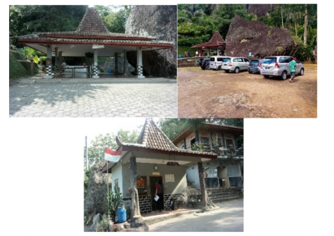
Nglanggeran is 26 km from Yogyakarta and can be reached by road trip for 55-65 minutes. The road to this place is paved and cast concrete and can be passed by buses. Unfortunately, there is no public transportation available. Signs pointing the way to this place are pretty straightforward. To be able to enjoy the beauty of Nglanggeran, it takes reasonably good physical endurance because it must be passed by a 20-40 minute trip from the parking area to climb to the top of the ancient mountain with an elevation gain of 170-220m and a 10-15 minute trip from the parking area to climb to the reservoir, an elevation gain of 15-20m. in addition to providing the beauty of adventure special interest tourism attraction, this place also developed agro-tourism in Nglanggeran tourism village. Some of the facilities that have been available such as the management office, parking lot, and meeting hall have also been utilized by tourists and are well maintained by the manager (Figure 2).
Figure 1. Potential uniqueness of Nglanggeran Ancient Volcano Geosite
Figure 2. Facilities at Nglanggeran Ancient Volcano Geosite
The increase in tourist visits has started since the area's opening as a tourist destination in 2011. Previously, Nglanggeran was often visited by tourists, but it was still limited to educational or research tours. The increase in visits cannot be separated from the role of the Nglanggeran youth organization, which is trying to manage the Ancient Volcano research area as a tourist destination.
The development of Nglanggeran Village into a tourist village began with an environmental awareness movement in the Nglanggeran Ancient Volcano area in 1999, initiated by young men and women who were members of the Nglanggeran Village Youth Organization. The environmentally conscious movement is greening around the slope area of Nglanggeran Ancient Volcano with various productive plants such as cocoa (chocolate), bananas, kolonjono, mangoes, rambutan, mahogany, and others [26].
The increase in visitation to Nglanggeran (Figure 3) was sluggish when tourism opened in 2011. The number of tourists began to increase sharply in 2013. The peak of tourist visits occurred in 2014, with the number of visits reaching 325 thousand of visitors. However, the decline in 2017 was recognized again in 2018 and fell until 2021.
Figure 3. Graph of number of visits at Nglanggeran Ancient Volcano
Figure 4. Graph of the growth rate of visitation at Nglanggeran Ancient Volcano
The decline in the growth rate occurred in 2010-2012 and increased again in 2012-2014. Comparing the total number of visits shows a striking difference between before and after the designation as a geopark. However, visitor growth in this area tends to be dynamic and experienced a drastic decline in 2014-2015 (Figure 4). The case of Nglanggeran Geosite shows the link between increased visitation and geopark designation. Geopark-related promotions and campaigns led to a sizable increase at this site. However, the increase did not last long. In 2014, the growth of tourists in the area dropped dramatically in one year. However, the geopark campaign program is still being implemented. Limited attractions and the development of similar attractions are suspected to be one of the causes of the decline in growth.
The development of Nglanggeran Geosite as a tourism destination using the Butler model [27] as described by Mouhamadou Bamba-LY [28] occupies the consolidation stage of its destination development [29]. The growth of tourists at Nglanggeran Geosite has declined; however, the numbers are still significant. The tourism sector at this site is one of the main economic sectors of the community. Various community activities develop and are related to tourism. This increased economic role is due to the development of tourism products or the diversity of tourism products in the destination. Tourist visits still show a reasonably positive increase, but there has been price competition among similar companies in the region's tourism industry, such as for homestays and restaurants. Nglanggeran is the flagship tourist destination of Gunungkidul Regency, which allows Nglanggeran to promote itself with the government's help.
However, the increase in visits not accompanied by visit management sometimes causes complaints for tourists. The density of holiday visits sometimes makes tourists choose other places to visit. Population density has also resulted in a decline in the quality of the environment and some facilities. Problems arise from population density, such as the case of garbage at the top of Nglanggeran. Entrepreneurs outside the region have begun dominating tourism development in these two areas. The investment often made is land cooperation in developing restaurants or homestays. The role of area managers is increasingly visible and dominating compared to the role of the government. Land use change is defined as a rise in land usage or a change in the function of land through time [30]. Spatial interactions sometimes cause space utilization problems and land use changes in the form of the need to develop socio-economic activities. Tourism also has a role in driving land use change.
Figure 5. Land use map of Nglanggeran Ancient Volcano Geosite on early stage
Figure 6. Land use map of Nglanggeran Ancient Volcano Geosite on tourism stage
Tourism development certainly provides new demands in the form of meeting the needs of tourism facilities and tourist support facilities. Tourism facilities include 1) accommodation facilities; 2) restaurant facilities; 3) tourism information and service facilities, immigration service facilities, tourism information centers, and e-tourism kiosks; 4) tourism police and tourist task forces; 5) souvenir shops; 6) directions/tourist information boards/tourist traffic signs (tourism sign and posting); and 7) landscaping [31].
The development of tourism needs places demands on changes in existing land use at Nglanggeran geosite. Figure 5 shows the condition of land use before tourism developed in this area. Agriculture, fields, and settlements dominated land use in that period. Settlements developed along the main road, and simple public and commercial facilities developed between settlements.
The early development period shows that this area is an inhabited geological site that coexists with community life with village roads that use stone and dirt pavement. As shown in Figure 5, land use in this period was dominated by fields and the geological site of Mount Nglanggeran. In its development, the village road was upgraded to an asphalt road. The development in the Nglanggeran Ancient Volcano area began in mid-2011, with the opening of this area as a tourism destination. At the beginning of the development, the available amenity was still limited in the form of a retribution post and several grocery stalls that initially provided the local community's needs, slightly changed by providing some tourist needs. The needs provided are more on the basic needs of tourists, such as drinking water and food.
Figure 7. Activities in the core zone of Nglanggeran Ancient Volcano Geosite
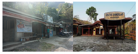
The spatial development in the tourism period (Figure 6) was dominated by land use for tourism facilities and amenity needs, including tourist support facilities. The community developed changes in settlement functions into accommodation in simple lodging or homestays, food stalls, grocery stores, retribution, and tourist information centers, as well as the construction of retribution posts, tourist management facilities, and tourist villages (Figure 7).
The process of changing the spatial elements that take place in this area is strongly influenced by the development of tourism that occurs (Figure 8). Since the period of tourism in this area began to be managed more neatly by youth organizations, more and more buildings have changed functions to become amenity or tourism support facilities. Some visible changes are the emergence of grocery stores and souvenir shops.
Spatial changes became more visible after entering the geopark stage or when the area became part of the Gunung Sewu Geopark, a UNESCO Global Geopark. Land use change also became more widespread with the construction of the Nglanggeran reservoir, originally a spring used to irrigate the surrounding orchards. These developments have resulted in the emergence of amenity and tourism support facilities.
Figure 8. Land Use Map of Nglanggeran Ancient Volcano Geosite on the Geopark Stage
Figure 9. Amenity at Nglanggeran Ancient Volcano Geosite
The development of Nglanggeran tourism village also goes hand in hand with developing this area as a geosite. The number and variety of visits gave rise to various facilities and amenities such as geosite management posts, geosite information centers, fields/rice fields developed into chocolate agro-tourism, geosite information boards, and built Embung Nglanggeran (Figure 9).
Developments in the geopark period became more visible as the attractions at Nglanggeran Geosite became more visible and spread to other parts of the area. Eighty homestays developed throughout the area, triggering the emergence of other amenities such as warungs and souvenir shops. In addition, the emergence of homestays also triggers the emergence of supporting facilities such as mosques. All developments in accessibility, amenity, supporting facilities, and institutions, which act as semi-fixed elements, develop outside the core zone of Nglanggeran Geosite. The core zone of the geosite (fixed element) in the form of ancient volcanic waste rock gets developed by developing natural tourist attractions without changing its function and shape. The process of spatial change is shown in Table 2, in the form of the process of change at each stage of development.
Table 2. Space change process of Nglanggeran Geosite
|
Indicator |
Early Stages |
Tourism Stages |
Geopark Stages |
Change |
|
Geological Sites |
Nglanggeran Ancient Mountainn |
- Tourist attraction |
- Geopark sites |
- Function - Status |
|
Commerce & Industry |
Grocery store |
- Shops for tourist - Food stalls for tourist |
- Shops for tourist - Food stalls for tourist |
- Function-form - Land size |
|
Settlements |
Settlements |
- Settlements with rooms for rent - Homestay |
- Settlements with rooms for rent - Homestay |
- Function-form - Land size |
|
Vacant land, rice paddies, fields |
Rice paddies, fields, moor |
- Rice paddies, fields, moorland - Stalls (at roadside locations) - Parking lot |
- Rice paddies, fields, moorland - Stalls (at roadside locations) - Geopark facilities - Parking |
- Function-form - Ownership status |
|
Road |
Village road |
- Road |
- Road |
- Function-form - Quality |
Table 3. Space change process of Nglanggeran Ancient Volcano Geosite
|
Early Stages |
Tourism Stages |
Geopark Stages |
Space Element |
Drivers of Change |
|
Nglanggeran Ancient Mountain |
Nglanggeran Ancient Mountain |
Nglanggeran Ancient Mountain |
Fixed |
- |
|
Nglanggeran Ancient Mountain Tourism |
Nglanggeran Ancient Mountain Tourism |
Non-fixed |
Tourism |
|
|
Commercial activity |
Commercial activity |
Non-fixed |
Tourism |
|
|
Nglanggeran Ancient Volcano Tourism Trail |
Nglanggeran Ancient Volcano Tourism Trail |
Semi-fixed |
Tourism |
|
|
Tourist Post |
Retribution post |
Semi-fixed |
Tourism |
|
|
Geopark Program |
Non-fixed |
Geopark Program |
||
|
Geosite management post |
Semi-fixed |
Geopark Program |
||
|
Geosite Information Center |
Semi-fixed |
Geopark Program |
||
|
Geosite information signboard |
Semi-fixed |
Geopark Program |
||
|
Embung Nglanggeran |
Semi-fixed |
Tourism |
||
|
Rice paddies/ moorland |
Rice paddies/ moorland |
Rice paddies/ moorland |
Fixed |
Agriculture |
|
Chocolate Agritourism |
Semi-fixed |
Tourism |
||
|
Traditional settlements |
Settlements |
Settlements |
Semi-fixed |
Tourism |
|
Homestay |
Semi-fixed |
Tourism |
||
|
- Shops for tourist - Food stalls for tourist |
- Shops for tourist - Food stalls for tourist |
Semi-fixed |
Tourism |
|
|
Shops |
Shops |
Semi-fixed |
Tourism |
|
|
Souvenir shops |
Semi-fixed |
Tourism |
||
|
Village road |
Asphalt/ concrete road |
Asphalt/ concrete road |
Semi-fixed |
Village development, Tourism |
|
Village land |
Tourist management facilities |
Tourist management facilities |
Semi-fixed |
Tourism |
|
Tourist Village Management |
Tourist Village Management |
Semi-fixed |
Tourism |
|
|
Hills, fields |
Embung Nglanggeran |
Semi-fixed |
Tourism |
|
|
Embung Nglanggeran Tourism |
Non-fixed |
|
||
|
Shops |
Semi-fixed |
Wisata |
||
|
Parking Lot |
Non-fixed |
Wisata |
The spatial change process at Nglanggeran Geosite occurs in all indicators used, but the change form differs (Table 2). Geological sites experience only changes in function, with no change in form. This change happens because the site's uniqueness is the main magnet for activity in this area. While in trade and industry, there are changes in function, area, and form. Simple stalls that existed in the early period developed into stalls or shops providing tourist needs and food stalls for tourist needs. The quality and size of the stalls also changed for the convenience of tourists. Settlements experienced changes in function, form, area, and quality. Residents' settlements begin to develop into settlements with rented rooms during the tourism period. This process grew when the number of tourists increased during the geopark period. Lodging mixed with the main house became a tourist rental house (homestay). On the part of vacant land, rice fields, fields in the process experience changes in function, form, and ownership status. Land that is still empty of buildings begins to overgrow with buildings due to the increasing need for tourism and supporting facilities such as stalls and inns, especially during the geopark period. Besides that, several new buildings have also emerged that were built for the needs of the geopark program. Changes to the road section are in the form of road quality improvements. This improvement is due to the addition of transportation modes that pass through the road section.
The development of tourism space in Nglanggeran Geosite has also begun to take shape since the tourism period. This development can be seen from the communication between tourists and the community, community activities related to tourism, community awareness to develop tourism, and the construction of tourism facilities. Land use at this geosite is also complete. When viewed with the division of land according to Yeates & Garner [32], which divides land into residential, industrial, commercial, roads, public land, and vacant land, all of these components are available in this geosite. Changes that occur can be observed in the Table 3.
Table 3 above shows that the land use process at Nglanggeran Ancient Volcano Geosite is dominated by changes in semi-fixed elements in the form of the construction of various buildings and land uses related to tourism. The fixed element in this geosite is the landscape of Nglanggeran Ancient Volcano. Within the fixed element, potential utilization activities develop into tourist attractions. These tourism activities continue to grow and trigger the growth of semi-fixed elements in the form of tourism support facilities, accommodation facilities, shops, stalls, and improved quality roads. The subsequent development is the entry of the geopark period; in this period, the fixed element changes its function as the Nglanggeran Ancient Volcano Geopark site. The emergence of this geopark function triggered the growth of several new semi-fixed elements in the form of geopark management posts and geopark information center. Spatial changes at the Nglanggeran Ancient Volcanic Geosite that occurred in the tourism period to the geopark period were strongly influenced by tourism developments in the area, both before becoming part of the geopark and after becoming part of the Gunung Sewu Geopark. In addition, the length of stay in this area of 4.09 hours also affects the emergence of tourist needs that impact the growth of stalls (amenity). The growth of amenities dominates the spatial changes that occur. The spatial changes that occur at the Nglanggeran Ancient Volcano Geosite are influenced mainly by two main things, namely tourism and the geopark program, but the dominance remains in changes caused by tourism activities that have an impact on semi-fixed space elements related to tourist needs.
Space development at Nglanggeran Ancient Volcano Geosite shows dynamic conditions, especially in semi-fixed and non-fixed elements. While the fixed element looks uniform, the fixed element is filled by the uniqueness and core of the geopark area. As a fixed element, the uniqueness and distinctiveness of the area are well maintained. One form of policy that is raised in the management of geopark areas is conservation policy, one of the impacts of which is to protect the uniqueness of geology and geomorphology. This policy impacts the unchanged or preserved Geosite core zone from damage (change). This phenomenon strengthens the position of the Geosite core zone as one of the fixed elements in the area's space.
Elements that occupy positions as semi-fixed elements in Geosite are spaces that change following the demands of tourism activity development and management as non-fixed elements. In addition, the access element also provides additional meaning to the semi-fixed element in the area's space. The demands of tourists need when traveling appear along with visitor activities in the Geosite. Visitor activities will also lead to the emergence of manager and community activities to fulfill visitor needs. These various activities have implications for the spaces in the Geosite and form semi-fixed elements in the geopark.
The results show that the permanent element in a geopark is the prominent uniqueness of the geopark. This geological uniqueness will be a precious asset and must always be maintained to maintain its uniqueness and sustainability. This uniqueness will drive visitation to the site. Nglanggeran Geosite has a tourism development characterized by the formation of tourism space. The spatial changes at Nglanggeran Geosite are caused by tourism development and the geopark development program. The pattern of spatial changes that took place is described in Table 4:
Table 4. The pattern of space change
|
Indicators |
The Pattern of Space Change |
|
Sites |
$\rightarrow$ Function addition $\rightarrow$ Tourism $\rightarrow$ Function addition $\rightarrow$ Geopark |
|
Commerce & Industry |
$\rightarrow$ Function change $\rightarrow$ Tourism commercial $\rightarrow$ Land size change $\rightarrow$ Land size addition $\rightarrow$ Quality improvement $\rightarrow$ Building repairs & improvement |
|
Settlements |
$\rightarrow$ Function change $\rightarrow$ Commercial settlements (lodging) $\rightarrow$ Function addition $\rightarrow$ Living house + lodging $\rightarrow$ Land size change $\rightarrow$ Land size addition $\rightarrow$ Quality improvement $\rightarrow$ Building repairs & improvement |
|
Vacant land, rice paddies, fields |
$\rightarrow$ Function change $\rightarrow$ Tourism facility $\rightarrow$ Function change $\rightarrow$ Commerce $\rightarrow$ Function change $\rightarrow$ Settlements $\rightarrow$ Function change $\rightarrow$ Road $\rightarrow$ Function change $\rightarrow$ Commercial settlements (lodging) $\rightarrow$ Area reduction $\rightarrow$ No longer a vacant lot |
|
Road |
$\rightarrow$ Addition of function: road shoulder $\rightarrow$ Commercial (stalls) $\rightarrow$ Quality improvement: soil $\rightarrow$ Macadam $\rightarrow$ Asphalt/Concrete castings $\rightarrow$ New road addition: vacant land $\rightarrow$ Road |
The process in Nglanggeran Geosite shows that this geological site developed through tourism. The development of the tourism period will bring up the tourism factor as the primary driver of change and the formation of tourism space in it. In line with Więckowski [6] that findings, the form of services provided is still simple, the form of food stalls or grocery stalls to the change of residential houses into homestays for the benefit of tourists. The interaction between tourists and the community for the benefit of tourism marks the formation of tourism space.
Referring to the understanding that tourism will develop in a unique space called tourism space, tourism space is the entire geographical and socio-economic area that forms a tourism phenomenon [6]. This explanation justifies the formation of tourism space at Nglanggeran Geosite, Gunung Sewu Geopark, UNESCO Global Geopark Network.
The formation of tourism space in this study indicates the development of a Geosite. Geosite that develops into a tourism destination will show the existence of tourism space. The spatial changes that occurred in the two periods, both the tourism and geopark periods, have different characters based on their causes. Although ideally, the two processes can combine to get ideal results. The description of these changes are:
Figure 10. Process of space element change
Figure 10 shows that the primary process of spatial change at Nglanggeran Geosite, Gunung Sewu Geopark, UNESCO Global Geopark Network based on its spatial elements starts from forming fixed elements or in the form of the prominent uniqueness of the geopark (site). The attraction triggers the growth of activities by utilizing the potential of existing uniqueness. The activity stimulates the growth of various facilities that act as semi-fixed elements related to the motivation for a visit.
The process takes place in two primary forms, namely, the process of spatial change related to tourism and not related to tourism. The process of space change related to tourism, tourist attractions, and their uniqueness act as fixed elements, while tourist activities become non-fixed elements that require forming tourism support facilities as semi-fixed elements.
This process demonstrates that the community as the host and the government as the policyholder intervenes in constructing semi-fixed components. While spatial change is unrelated to tourism, the geological site still gets a role as a fixed element that encourages the growth of various activities related to the fixed element, which later acts as a non-fixed element. Non-fixed elements in this process do not encourage the formation of semi-fixed elements. Semi-fixed elements are created due to policies related to developing fixed elements.
The process of spatial change is the primary component that occurs when a region develops, as well as creating a geopark as a tourism destination. The spatial elements that influence land use change in Gunung Sewu Geopark are grouped into three groups based on the findings of Rapoport [22-24]; by adjusting the contextuality that occurs in the field are:
A. Fixed Elements, the core element of the geopark, is fixed, stable, and unchanged, protected by regulations for conservation purposes and regional icons, in the form of natural formations (Mountains, Valleys, Caves, Rivers, natural landscape of the area).
B. Semi-fixed elements; This Is a companion element, is volatile, not permanent, and can be changed or removed at any time, in the form of supporting facilities in the form of buildings, amenities, accessibility, and environmental planning.
C. Non-fixed elements; This Is a new element, very changeable, in the form of human activities, such as tourism, hawkers, and Geosite management activities.
The meaning of elements contained in the geopark is also meaningful as a relationship of interconnection and coordination that takes place in it. This finding is similar to that of Heidari et al. [33], who examined the function of spatial elements in a house. In this case, the elements are spatial elements in a geopark. The elements within the geopark are influenced by tourism activities as well as the geopark development program.
This research found that the process of spatial change in Nglanggeran Geosite, Gunung Sewu Geopark UNESCO Global Geopark Network was caused by external factors (tourism) that triggered an increase in income through the development of various tourism service businesses, namely food stalls, grocery stalls, homestays, guide services, and others. The process of spatial change influenced by tourism development occurs by forming geopark tourism space. The formation of geopark tourism space comes from changes in semi-fixed elements due to the need for non-fixed elements related to activities as a result of the attraction of fixed elements in the form of geological potential as a nature-based tourist attraction that provides a visit experience, tourism services, and support from the community, government, and private sector. The development of tourism influences the change in space in the form of the emergence of tourism space caused by aspects of increasing the number of tourist visits, the availability of facilities and accessibility, the uniqueness and authenticity of tourist attractions, the role and involvement of government and society, investment growth, planning and promotion, shifting social and cultural values, the existence of management institutions, and also the innovation of tourism products in the geopark.
Further research that should be carried out to complement this research is research related to the impact of spatial changes on community welfare. this is very important considering that the ultimate goal of tourism development and also regional development is the achievement of a prosperous community.
This research is part of independent research carried out to fulfill the Tri Dharma of higher education in the form of research and service in the tourist village of Nglanggeran. The author would like to thank the research and community service institute at the Ambarrukmo Tourism Institute (STIPRAM) for all their assistance in carrying out this research.
[1] Andriani, D., Pitana, I.G. (2011). Ekowisata: Teori, Aplikasi, dan Implikasi. Jurnal Kepariwisataan Indonesia, 6(2): 181-193.
[2] Setyadhi Mustika, M.D., Putra Wijaya, I.B. (2014). Pengaruh Jumlah Kunjungan Wisatawan, Lama Tinggal dan Pengeluaran Wisatawan Mancanegara terhadap Pendapatan Sektor Perdagangan, Hotel dan Restoran (PHR) Provinsi Bali Tahun 2000-2012. E-Jurnal Ekonomi Pembangunan Universitas Udayana, 3(4): 124-133.
[3] Vitrianto, P.N., Nuryanti, W., Rahmi, D.H. (2021). Dynamics of tourism development in geosite, gunungsewu geopark. Journal of Sustainable Tourism and Entrepreneurship, 2(4): 213-232. https://doi.org/10.35912/joste.v2i4.836
[4] Vitrianto, P.N., Nuryanti, W., Rahmi, D.H. (2021). The role of tourism on a geosites's space development case: Watu Payung-Turunan Geoforest Yogyakarta, Indonesia. International Journal of Innovative Research & Development, 10(4): 198-213. https://doi.org/10.24940/ijird/2021/v10/i4/APR21052
[5] P. Republik Indonesia, UU Republik Indonesia Nomor 26 Tahun 2007 tentang Penataan Ruang. Republik Indonesia: https://peraturan.bpk.go.id/Home/Details/39908/uu-no-26-tahun-2007, pp. 1-56.
[6] Więckowski, M. (2014). Tourism space: An attempt at a fresh look. Turyzm, 24(1): 17-24. https://doi.org/10.2478/tour-2014-0002
[7] Prince, S. (2017). Imagining tourist spaces as living spaces: Towards a relational approach to alternatives and morals in tourism. Doctoral dissertation, Mid Sweden University.
[8] Rapoport, A., Altman, I., Wohlwill, J.F. (1980). Human Behavior, Environment and Culture. New York: Plenum Press.
[9] Wijaya, I.K.M. (2019). The semiotics of banyan tree spaces in Denpasar, Bali. International Journal on Livable Space, 4(2): 48-59. https://doi.org/10.25105/livas.v4i2.5564
[10] Wahyunto, A., Priyono, A., Sunaryo. (2001). Studi perubahan penggunaan lahan sub DAS Citarik, Jawa Barat dan DAS Kaligarang, Jawa Tengah. Seminar Nasional Multifungsi Lahan Sawah, pp. 39-40.
[11] Informasi Dokumen. (2009). Undang-undang Republik Indonesia Nomor 10 Tahun 2009 tentang Kepariwisataan. https://jdih.kemenparekraf.go.id/katalog-1-produk-hukum.
[12] Zakaria, F., Suprihardjo, R. (2014). Konsep pengembangan kawasan desa wisata di desa bandungan kecamatan pakong kabupaten pamekasan. Jurnal teknik ITS, 3(2): C245-C249. http://dx.doi.org/10.12962/j23373539.v3i2.7292
[13] Vitrianto, P.N., Patiyusuf, M. (2022). Cultural tourism development strategy of Penyengat Island Tanjungpinang City. Jurnal Mantik, 6(3): 3041-3050. https://doi.org/10.35335/mantik.v6i3.3045
[14] Buhalis, D. (2000). Marketing the competitive destination of the future. Tourism Management, 21(1): 97-116. https://doi.org/10.1016/S0261-5177(99)00095-3
[15] Cooper, C., Fletcher, J., Gilbert, D., Wanhill, S., Shepherd, R. (1998). Tourism: Principles and Practice. Essex, UK: Longman Group Limited.
[16] UNESCO, UNESCO Global Geoparks contributing to the Sustainable Development Goals, 7, place de Fontenoy 75352 Paris 07 SP France, 2017. http://www.europeangeoparks.org/wp-content/uploads/2012/03/Geoparks_Guidelines_Jan2014.pdf.
[17] Robinson, A.M. (2015). Geotourism and Geoparks A Tourism Development Opportunity for Australia. Australia: Ecotourism Australia Ltd.
[18] Mc Keever, P.J., Zouros, N. (2005). Geoparks: Celebrating Earth heritage, sustaining local communities. Episodes Journal of International Geoscience, 28(4), 274-278. https://doi.org/10.18814/epiiugs/2005/v28i4/006
[19] Komoo, I. (2016). Model for environmental sustainability: A case of langkawi UNESCO global geopark. Synthesis, 3: 4.
[20] Ridwan, Yuliawan, R., Aly, M.N. (2020). Tourism development in Bantaeng District, SouthSulawesi. International Journal of Psychosocial Rehabilitation, 24(9): 2845-2853. http://eprints2.ipdn.ac.id/id/eprint/1017/1/PR290316.pdf.
[21] Golafshani, N. (2003). Understanding reliability and validity in qualitative research. The Qualitative Report, 8(4): 597-607. https://doi.org/10.46743/2160-3715/2003.1870
[22] Rapoport, A. (1997). Human Aspects of Urban Form: Towards a Man-Environment Approach to Urban Form and Design. New York: Pergamon Press.
[23] Rapoport, A. (2005). Culture, Architecture and Design. Chicago Illinois: Locke Scientific, 2005.
[24] Rapoport, A. (1980). Human Aspect of Human Form: Towards a Man Envionment Approach to Urban Form and Design. Oxford, p. 46.
[25] Samodra, H. (2015). Geopark Nasional Gunung Sewu, Sebingkai Potret Warisan Bumi.
[26] Hermawati, P.R. (2020). Komponen kepariwisataan dan pengembangan community based tourism di desa wisata nglanggeran. Jurnal Pariwisata, 7(1): 31-43.
[27] Butler, R.W. (1980). The concept of a tourist area cycle of evolution: Implications for management of resources. Canadian Geographer/Le Géographe Canadien, 24(1): 5-12. https://doi.org/10.1111/j.1541-0064.1980.tb00970.x
[28] Bamba-LY, M. (2018). Application of Butler’s (1980) tourist area life cycle to saly (Senegal). International Journal for Innovation Education and Research, 6(1): 47-56. https://doi.org/10.31686/ijier.vol6.iss1.919
[29] Vitrianto, P.N. (2021). Pengaruh Pariwisata Terhadap Perubahan Ruang Kawasan Geopark. Universitas Gadjah Mada.
[30] Surya, B., Ahmad, D.N.A., Sakti, H.H., Sahban, H. (2020). Land use change, spatial interaction, and sustainable development in the metropolitan urban areas, South Sulawesi Province, Indonesia. Land, 9(3): 95. https://doi.org/10.3390/land9030095
[31] Informasi Dokumen. (2011). Peraturan Pemerintah Nomor 50 Tahun 2011 tentang Rencana Induk Pembangunan Kepariwisataan Nasional Tahun 2010 - 2025. https://jdih.kemenparekraf.go.id/katalog-319-produk-hukum.
[32] Yeates, M.H., Garner, B.J. (1980). The North American City. Third Edit. San Francisco: Harper & Row.
[33] Heidari, A.A., Mohammad, H.P., Behdadfar, N. (2014). Reading a home: An application of rapoport's viewpoint in iranian architecture studies. International Journal of Architecture and Urban Development, 4(1): 63-76.