Miloud Benmedjahed*![]() | Abdeldjalil Dahbi
| Abdeldjalil Dahbi![]() | Abdelkader Hadidi
| Abdelkader Hadidi![]() | Abderrahmnane Khelfaoui
| Abderrahmnane Khelfaoui![]() | Samir Mouhadjer
| Samir Mouhadjer![]() | Omar Djaafri
| Omar Djaafri![]()
© 2023 IIETA. This article is published by IIETA and is licensed under the CC BY 4.0 license (http://creativecommons.org/licenses/by/4.0/).
OPEN ACCESS
This paper represents a study on a survey and statistical analysis of ground water resources in Adrar region in southern Algeria, with a presentation of the used irrigation methods especially Foggaras system, which is not only an irrigation method, but a way of life and cultural heritage. We noticed that the Foggaras suffer from several problems, such as lack of maintenance and random excavation, in addition the pollution especially with sewage water. We also noticed that despite the abundance of renewable energy resources, especially solar and wind energy, these resources are rarely used for irrigation or pumping. Therefore, as responses to these issues, many proposals were presented, which are mostly related to the exploitation of renewable energies for pumping and irrigation with clean water and managing it rationally to obtain the best yield and promote sustainable development.
hydrogeology, Foggaras, solar energy, wind energy, smart remote irrigation system, Adrar
Mankind has managed to adapt to the harsh desert climatic conditions, which are characterized by scarce precipitation and a high temperature, by exploiting groundwater resources. In addition thanks to the presence of some oasis that is available on agricultural and animal diversity [1]. The term oasis came from ancient Egyptian language, which means the inhabited area, and it was used by the geographer Herodotus around 450 BC [2].
Much research has been done on irrigation systems in the oases of the Maghreb, such as Todgha Farkala in Morocco. These oases are affected by bad water management; In addition to migration to urban areas. Therefore, investments were proposed based on the use of fossil fuel pumps to revive the agricultural sector [3-5].
In Algeria, some researches were focused on the inventory of groundwater sources, as well as the impact of modern wells random drilling on the hydraulic level of groundwater, which led to the lack of water reaching to Foggaras and thus the drying of its sources [6-8].
Since Algeria’s independence in 1962, the traditional management of water resources in Algerian oasis has been a feature of most of the oasis, which has led to several problems mainly related to the bad well managements, springs and blowers with the waste of water resulting from misuse [4]. In addition, climate change and an increase in temperature due to global warming. Therefore, Mohamed and Remini proposed an effective water control to address the problem of water distribution in rural areas [9].
Numerous studies have shown that Adrar region is rich in groundwater re- sources and fossil energy. It also contains huge solar potential [10-12] and significant potential of wind energy and the same for the wind potential [13-15].
In order to provide practical and sustainable answers against environmental problems by preserving energy resources of fossil origin, Algeria is firmly committed to the path of transition towards renewable energies, where the huge potential of solar energy is the driving force behind this strategic decision. The thermal solar energy and solar photovoltaic energy provide a large part of the national program for the energy transition, which should represent 37% of electricity production in the country by 2030. The program does not exclude wind energy, which represents the second axis of development, which should be about 3% of electricity production [16-36].
In this paper, at first Adrar region will be described in terms of physical, natural and human environment. After that, the ground water resources and the potential of renewable energies (photovoltaic and wind energy) will be focused on. Then, the number and types of available water sources will be counted, the used irrigation methods, and the observed difficulties will be investigated. In the next section, the use of these renewable energies in irrigation, pumping and Smart Remote Irrigation System in Adrar region will be studied. Finally, important recommendations will be added in order to rationalize the use of water and preserve the cultural heritage represented in Foggara, as well as the contribution to the energy transition.
At first, the initial state of the physical, human and natural environment is studied and analyzed. After that, a careful field investigation is carried out in several aspects, such as geography (location, and estimation), special characters (aesthetic aspect, originality, and rarity), the quality of the environment, and the level of its protection, with an examination of the environment elements. This investigation is carried out according to the following stages:
Visiting of the agricultural production site;
Water data collection and assessment;
Data on the used irrigation systems;
Estimate the potential of solar and wind energy;
The state of Adrar is located in south-western Algeria, bordered in the north by the Timmons region, in the south by the Bordj Badji region, in the east by Ain Salah and in the west by Tindouf, Beni Abbas and Mauritania. The population of Adrar is 246.825 people (in 2011), distributed among 16 municipalities. Its total area is more than 233475 km2 [23].
2.1 Relief
The studied area is bordered in the north by Erg El Gharbi, to the south by the Tanzirouft plateau, and in the east by the Tadimat plateau, which is an extension of the Mzab mountain range that separates the eastern Erg from the western Erg. The sandy parts consist of the southern boundary of the western Erg and the Chash Erg to the west. The terrain height can reach 636 m in the southern Erg border of Adrar (NOAA 2008) [37]. In this paper, topographic map of the Adrar region has been created based on the World Topographic Atlas (see Figure 1).
Figure 1. Topographical map of the Adrar region
2.2 Climate
Koppen describes the desert climate in the Adrar region as being characterized by extreme drought with little or no rainfall, and a very hot weather. In addition to very strong solar radiation with a long duration of brightness in large parts of the state, and a very low humidity [2].
Based on the weather data recorded in 2021, this description is confirmed, the maximum recorded temperature was 45 degrees Celsius in August (Fenougil site), and the lowest recorded temperature was 5 degrees Celsius in February (the Sabaa site). The average annual precipitation ranges from 0.7 mm in the sites of Akbili, Tasabit, and Timu Qutan to 1.1 mm in the Sabaa site. While the average annual humidity ranges between 19.6% in Oulef site to 22.2% in Sabaa site.
2.3 Geology
The studied region is characterized by the (Cratonic) field. This later has been stable for 550 million years. It includes two shields where metamorphic and igneous rocks emerge representing two ancient mountain ranges, and a platform called the desert platform, which is built in sedimentary basins filled with animal sediments [38]. In this work a geological map of the Adrar region has been also created using the African Geological Atlas [39] (see Figure 2).
Figure 2. Geological map of the Adrar region
2.4 Fauna and flora
Desert animals that have adapted to the desert environment create their own defense mechanisms to withstand the heat and scarcity of water. Where we find cuff sheep (in mountainous areas), deer (open spaces, valleys), fennec foxes, jackals, hares, small rodents such as gerbils, etc. are widely found among mammals, and their traces can be seen easily. Antelope species at risk of extinction [23]. The sand fish, also known as Churchman, is a type of lizard that inhabits the desert; it is found in the southern hemisphere, while the vegetation in Adrar region is divided into two types, an agricultural plant type and a natural one.
2.5 Hydrogeology sources
The studied area is located in the North Sahara Aquifer System (SASS), which extends over an area of 1,100,000 km2 across Algeria, Libya and Tunisia, and it is located north of the Sahara [2]. It consists of two main groundwater reservoirs: the Intercalary and the Terminal Complex, which together contain large reserves of groundwater, estimated about 3,270,000 m3. This region is bordered by the Saharan Atlas from the north, the Green Hun region (in Libya) from the east, the Saura Valley from the west, the outcrops of Tedicelt and the southern edge of the Tenrart River from the south [40].
The SASS Basin consists of three sub-basins: the Hamada Al-Hamra Plateau in the east, the Great Eastern Erg Basin in the center, and the Great Western Erg Basin in the west. The SASS basin also contains the terminal complex and it has two reservoirs consisting of a number of aquifers that present in this basin (TC) [40].
In recent years, Adrar region has witnessed a massive drinking water supply (DWS) thanks to the increase in water storage capacities and the development of the water delivery network. This region also benefited from water projects that resulted in the construction of new wells and the installation of supply lines. We find from statistics in regions that include Adrar, Timimoun and Bordj Beji Mokhtar, approximately 811 wells used to supply groundwater with a flow rate of 30.4 m3 / day, or 319 million m3 annually [2]. Wells are the main source of water supply, especially for irrigation. The estimation of the exploited wells are about 11,307 wells in the aforementioned areas, which provide daily filling of an estimated 2,452,491 m3 of the exploited flow [2].
The water required for plants is usually provided by surface water (flowing waters and valleys) and ground resources due to the severe lack of precipitation in Adrar region [37]. However, due to the scarcity of irrigation water with its irrational control, only a few palm farm will benefit this water on one hand. On the other hand, the excessive irrigation is harmful to the soil, vegetation cover, and agricultural production [37].
Water can be collected occasionally using a traditional system named Foggara. The first Foggara of Tamantit was constructed by Almohadin in the 11th and 12th centuries, with a total length of 2,300 km. Their number is 758, but 369 of them have dried up [2].
The presence of the topography results in a reflection in the piezometric profile of the local groundwater currents, which only appears in wadis or sabkhas (areas of low pressure), as it is the case with Touat region. The same is true concerning the palm groves of Ghorara and Tidikelt, but there are many small enclosed depressions instead of one long depression with a ridge aligned with the Foggaras, each of them allowed the development of the Foggara system and the appearance of oasis [2].
The water obtained from the Foggara is distributed using a pot system named Kasria, which is like a stone comb with a sufficient number of holes, so that the water can flow easily in order to distribute and prevent large flows at the same time. Sometimes more than one outlet distributes water in the same stream (canal) directed to a particular farmer, where the number of outlets is related to the percentage of each farmer’s contribution and the area of his cultivation. There are many Kasrias that dispense the water of the Foggara, but the large Kasria is the first to be reached by the full flow of the Foggra. The latter end in Al Mijras with a secondary Kasria which distributes the water to the waterwheel [2].
2.6 Sources of renewable energy
Adrar region has clean renewable energy resources, which can be exploited effectively. However, technologies to extract energy from these resources, which have been neglected for a long time, require more research concentration and development with the aim of making them more reliable, reducing costs (manufacture, use and recycling) and increasing energy efficiency. Since this area is far from the electric grid and has an excellent potential for solar and wind energy, photovoltaic and wind energy are focused.
The required hydraulic power can be simply calculated by determining the necessary needs in the volume of water for each month and the characteristics of the well. The average daily hydraulic needed power can also be calculated from the following relationship (1) [41]:
$E_h=g \rho_a Q h / 3600$ (1)
Eh is hydraulic energy (kWh/day), h is total height (m), Q is the flow rate provided (m3/day), ρw is water density (1000 kg/m3), and g is acceleration due to gravity (9.81 m/s2).
During the pumping process, the water level inside the well tends to decrease; the well is replenished to balance the well water level so that water can be pumped out again. The drop in the water level in the well depends on a number of factors, such as the type and permeability of the soil and the thickness of the aquifer. The total pumping height is the sum of the static height hs and the dynamic height hd (see Eq. (2)) [41]:
$h=h_s+h_d$ (2)
In the case of using solar energy, the daily electrical energy Ee, is given by [41]:
$E_e=\eta_{p v} A G_{d m}(\beta)$ (3)
A is active area of the photovoltaic generator (m2), ηpv is average daily efficiency of the generator under operating conditions, and Gdm (β) is average daily irradiation incident on the plane of the modules at the inclination β.
The needed electrical power is related to the hydraulic power, it can be expressed by [41]:
$E_h=\eta_{p m} E_\epsilon$ (4)
The flow rate is calculated using [41]:
$\mathrm{Q}=\frac{3600 \eta_{p m} \eta_{p v} A G_{d m}(\beta)}{\rho g h}$ (5)
In the case of wind turbines, the average electric power (Pw) provided by the wind turbine is estimated by [42]:
$P_w=\int_{v_d}^{v_a} p(v) f(v) d v$ (6)
vd and va are, respectively, the zero-flow speed and the stop speed of the wind turbine.
P(v) is the variation of the electrical power supplied by the wind turbine with the wind speed v (see Eq. (7) [22]):
$p(v)=\frac{1}{2} \rho S C_p v^3$ (7)
Cp is capped by force of wind turbine, ρa is air density (kg/m3), and S is surface perforated by wind turbines.
f(v) is the density function of the wind velocity distribution. With the as assumption that this distribution is represented by Weibull statistical law (8) [22]:
$f(v)=\frac{k}{C}\left(\frac{v}{C}\right)^{k-1} \exp \left(-\left(\frac{v}{C}\right)^k\right)$ (8)
k, C are shape and scale parameters of Weibull respectively.
Finally, the average flow Q is evaluated using [43]:
$\mathrm{Q}=\frac{\eta_{p m} P_e}{\rho g h}$ (9)
3.1 Sources and methods of irrigation
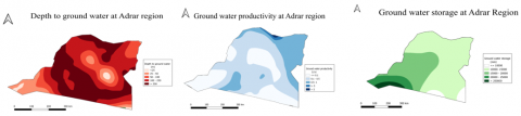
In this work we created groundwater maps of Adrar region (Figure 3), based on research on groundwater maps of African continent [44].
It is noted that the productivity of the north-eastern region exceeds 10 l/s, as it can provide the needs of large cities, a significant number of factories, and sufficient use of irrigation. It can be also observed that the depth of the groundwater for this area is suitable, as it is less than 65 m. The productivity ranges between 2 and 10 l/s in the eastern zone, and at selected sites in the southern zone. Thanks to that, small village can be created using modest powered pumps with a depth of less than 65 m, while the groundwater reserve in the eastern and northern zones is less than 1700 mm, while the percentage increases as towards the southwest.
Figure 3. Productivity, depth and storage of groundwater maps of the Adrar region
Figure 4. Number of wells, Foggaras, and drillings at Adrar region
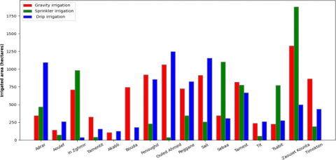
Figure 5. Irrigated area at Adrar region
In order to compare different irrigation systems we visited some fields and farms. We collected and analyzed data on water demand and renewable energy use. First, the total number of wells, Foggaras, and drilling at the regional level. Results and details are shown in the Figure 4:
From Figure 4, three types of water sources for irrigation can be distinguished:
3.1.1 Wells
It can be said that wells are present in all the studied sites, and their number is the largest compared to other sources of water. It ranges from two wells in Ouled Ahmed to 784 wells in Reggane.
3.1.2 Drilling
The number of artesian drilling ranges from 3 in Tit and Bouda to 95 in Zaouite Kounta. We also noticed the absence of these drilling in some regions especially in Tamentit, Akuabli, Ouled Ahmed and Tamest.
3.1.3 Foggara
In spite of the absence of traditional Foggara system in Sabaa, in the other sites, the number of explosions ranges from 2 explosions in Tit to 35 explosions in In Zaghmir and Reggane.
Foggara is a way of life that has existed for more than a thousand years instead of the water supply system. It can be protected by informing the managers and owners of wells, repairing wells, and adjusting the flow rates of wells in Al-Foggara. Increasing the flow of Foggara, in addition to the use of pumps powered by solar energy or wind energy to strengthen the flow.
Moreover, a safe distance (> impact radius) must be respected when drilling new wells to avoid interference phenomena and direct contact with the intake cone. The dryness of Foggara is often due to the lack of maintenance, the low level of groundwater resulting from excavations, as well as exposure to various forms of pollution, especially waste (Energy Sector Management Assistance Program ESMAP 2018), due to the absence or lack of sewage networks, which affects the quality of fresh water. The preservation of resources intended for human consumption is a top priority through the application of the rules related to the preservation of these resources from pollution and the effectiveness of the paragraph.
In this context, we have created a graph of irrigation systems for all sites in Adrar region based on the data collected about agricultural irrigation systems, as it can be seen in the Figure 5. Three main types of irrigation can be distinguished as following:
3.1.4 Gravity irrigation
In this type of gravity irrigation all irrigation methods are combined which allow water to flow simply over the surface of the soil to cover the entire irrigation area under gravity irrigation (see Figure 6). The land geography and the soil capacities allow the water-holding (runoff, infiltration). This irrigation system is well-established with a long history, low cost and low energy requirement, while the disadvantages of this type can be seen in the long time required for water distribution, as well as the large waste of water, consequently poor efficiency. This type of irrigation is used in an area ranging from 108 hectares in Akabli to 1327 hectares in Zaouit Kounta.
Figure 6. Gravity irrigation system [2]
3.1.5 Sprinkler irrigation
The sprinkler irrigation is recommended when the soil is too permeable to allow an uniform distribution of water during runoff irrigation or it is too shallow to be properly levelled for surface irrigation while retaining sufficient depth (see Figure 7). In Buda this system is not used; the irrigated area ranges from 5 hectares in Akabli to 1876 hectares in Zaouit Kounta. However, its use should be avoided in areas frequently exposed to strong winds as it can lead to very irregular watering and also when plants are irrigated with saline water as the plant leaves are sensitive to salinity. The size and shape of the surface to be irrigated, its topography, and the type of soil must be taken into account. The quantity and quality of available or potential water sources. All weather conditions should be taken in consideration when sizing any pressurized irrigation system. The benefits of this system include high efficiency, water economy, flexible ground, and technology that can adapt to any type of soil.
Figure 7. Sprinkler irrigation system [2]
3.1.6 Drip irrigation
Drip irrigation is relatively a recent technique, whereby water is supplied to the plant in small doses, wetting part of the soil in the process and reducing evaporation and percolation loss (see Figure 8). It also inhibits the growth of weeds. It uses stable and lightweight gear, while often requiring supplementary gear via hydraulic valve related control units. Compared to sprinklers, this technology saves energy while conserving water. The aesthetic appearance or aesthetics of gardens or gardens is not affected by the potential for marginal water use, the reduction of weeds and parasites, the improvement of soil structure, or the aesthetic advantage in the case of sub- surface irrigation. The problem with drip irrigation is that physical debris, chemical residue, and biological agents clog the openings. Using specialized anti-blocking equipment can mitigate this problem, but the cost will go up and may harm plants. This system is used throughout the region, with irrigated areas ranging from 38 hectares at in Zaghmir to 1246 hectares in Aouled Ahmed.
Figure 8. Drip irrigation system [2]
3.2 Possibility of using renewable energies for pumping and irrigation
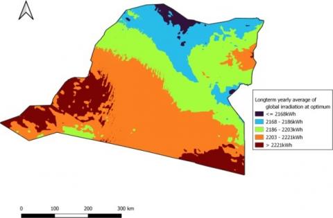
In order to find out the possibility of using solar energy and wind energy for pumping and irrigation, we made in this work the solar atlas and the wind energy atlas at a height of 50 m from the ground in Adrar region using data from the global solar atlas [44] and global wind atlas [45] (see Figures 9 and 10).
Figure 9. Solar Atlas of the Adrar region
Figure 10. Wind Power Atlas at 50m from the ground of the Adrar
As it can be seen, Adrar region has a huge potential of solar energy throughout the region, as the long-term annual average of solar radiation ranges from 2168 kWh in the northern regions to 2186 kWh in the far south. The value increases to a maximum of about 2221 kWh in the extreme south- west of the region.
The northeastern zone of Adrar belongs to the fourth category of wind classification (LNP). This means that it is a suitable area even for isolated wind turbines or wind farms. For the third category of classification there are seven zones. This means that it is a suitable area for the preparation of hybrid systems or isolated wind turbines.
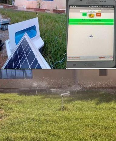
The calculation and simulation results showed that: to pump a 20 m well in Adrar, a photovoltaic system consisting of 8 photovoltaic panels with a power of 100 watts of each, they can be used to provide a flow equal to 10 m3/day, with an estimated energy consumption of 1557 kWh/year. How- ever, if we want to double the flow to be (20 m3/day), wind turbines can be used with a nominal power of 1.5 kW, which produces an estimated energy of 3241 kWh/year. In this research context, we developed a smart remote control system for irrigation, where we created a prototype that allows to realize manually and automatically control the watering of plants, in addition to providing the necessary climate measurements and agricultural data to farmers. To carry out this work, we used many sensors such as the fire and rain sensor, where the information is processed and displayed through the control unit represented by the Arduino card connected to the Android application that we programmed on the Smartphone and the LCD display panel (see Figure 11).
Figure 11. Agricultural smart irrigation system, using the application of remote control
The aim of the idea of this model is to create an agricultural project with high efficiency in terms of ease and accuracy in controlling the needs of agricultural plants while rationalizing the consumption of water resources, in addition to saving time and physical effort for the farmer thanks to the automatic and manual control system remotely by smart phone. As well as compensating the costs of electricity generation by utilizing solar energy, thus contributing to food security and the energy transition. This system has been verified in a real garden and has given very satisfactory results. Except for a few farmers who only use photovoltaic energy for pumping, there is little use of renewable energy in agriculture in Adrar, despite the huge potential of the region for both solar and wind energy [46, 47].
Almost the only places where wind energy is used in government project and very few farmers. We distinguish the wind farm in Kaberten of Sonalgaz (distributor of electric power) with a capacity of 10 Megawatts to supply the electric grid.
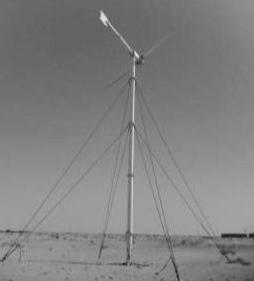
Although historically, the first experience of pumping water using a wind turbine (with a diameter of 15 meters) was in Adrar in 1953 (see Figure 12), this system is still less used. We can find a wind system for pumping water which was constructed in Ksar Ben Daraw Bouda (see Figure 13). Another turbine was constructed in the Baamour located in Fonuguil (see Figure 14). However, we discovered that this system was no longer working.
Figure 12. Wind turbine installed in 1953 (Adrar) [48]
Figure 13. Pumping wind turbine in Bouda [48]
Figure 14. Pumping wind turbine in Baamour [48]
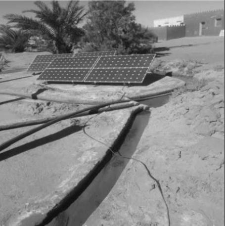
Concerning the solar energy, it is possible to refer to the efforts made to in- crease the flow of the Foggara, as in the case of Ait Messaoud (see Figure 15), in a site owned by the Reggane Company, which contains a photovoltaic system for water pumping that was installed in 2015 in cooperation with a number of government agencies. As well as Amguid located in Tamantit areas in Adrar (Figure 16), which contains a photovoltaic water pumping system for irrigation. This latter is a powerful system that works at an efficient rate. In terms of solar power plants, they generate approximately 53 MW across Adrar region.
In terms of preserving fossil resources and diversifying renewable energy sources, integrating renewable energies in the country is a major challenge. These energies, in particular the widespread expansion of solar and wind energy, the introduction of biomass (waste recovery), and geothermal cogeneration, are at the core of Algeria’s energy and economic strategies according to the Renewable Energy Development Program 2011-2030. Regarding the social acceptance of a new energy system for domestic and industrial power generation in the Adrar region based on renewable resources, the results of the questionnaire carried out within the framework of the research indicate that although the vast majority of people find it socially acceptable. However, there are many requirements that must be taken into account. The action plan was highlighted in the desert environment, such as the Adrar region. According to the expectations of the participants and the farmers, there are challenges, especially in the field of financing for farmers. Funding is only available for irrigation equipment, but there is no funding for equipment that generates electricity with renewable energies for agricultural use. As well as digitization and intelligent irrigation control.
Figure 15. Photovoltaic pumping in the Ait Messaoud site [48]
Figure 16. Photovoltaic pumping in the Amguid-Tamentit site [48]
This paper aims to study the different irrigation methods and the use of renewable energies in irrigation. As a result, we have tried to make the following suggestions:
|
A |
the active area of the photovoltaic generator m2 |
|
C |
the scale parameter of Weibull |
|
Cp |
the capped by force of wind turbine |
|
Ee |
the daily electrical energy kWh/day |
|
Eh |
hydraulic energy kWh/day |
|
f(v) |
the density function |
|
G |
acceleration due to gravity 9.81m/s2 |
|
Gdm (β) |
the average daily irradiation incident on the plane of the modules kwh/m² |
|
H |
total height m |
|
hd |
the dynamic height m |
|
hs |
the static height m |
|
k |
the shape parameter of Weibull |
|
P(v) |
the variation of the electrical power supplied by the wind turbine with the wind speed v |
|
Pw |
the average electric power w |
|
Q |
the flow rate provided m3/day |
|
S |
the surface perforated by wind turbines m² |
|
va |
the stop speed of the wind turbine m/s |
|
vd |
the zero flow speed m/s |
|
Greek symbols |
|
|
β |
the inclination rad |
|
ηpv |
the average daily efficiency of the generator under operating conditions |
|
ρa |
the air density kg/m3 |
|
ρw |
water density 1000 kg/m3 |
|
Subscripts |
|
|
Erg |
the dunes desert, more precisely a field of fixed dunes of which only the superficial sand is constantly remodeled by the wind. |
[1] Benhamza, M. (2009). Aperçu hydrogéologique et hydro chimique sur le système de captage traditionnel des eaux souterraines «foggara» dans la région d’Adrar. Mémoire de Magister. http://www.secheresse.info/spip.php?article26683.
[2] Hadidi, A., Saba, D., Benmedjahed, M., Blal, M. (2022). An overview on the development of the irrigation system in the province of Adrar (Algeria). Arabian Journal of Geosciences, 15: 854. https://doi.org/10.1007/ s12517-022-10103-8
[3] de Haas, H. (2006). Migration, remittances and regional development in Southern Morocco. Geoforum, 37: 565-80. https://doi.org/10.1016/j.geoforum.2005.11.007
[4] Boutadara, Y. (2009). Etude hydrogéologique des systèmes de captage traditionnels dans les Oasis Sahariennes Cas des Foggaras de la région du Touat (Adrar). Université des Sciences et de la Technologies d’Oran. http://univ-usto.dz/theses_en_ligne/index.php?lvl=notice_display&id=523.
[5] Benziouche, S.E., Chehat, F. (2010). La conduite du palmier dattier dans les palmeraies des Zibans (Algérie) Quelques éléments d’analyse. European Journal of Scientific Research, 42: 644-60.
[6] Hadidi, A., Yaichi, M., Saba, D., Habi, M. (2019). An overview of the traditional irrigation system (Foggaras) in Taouat Region. AIP Conference Proceedings, AIP Publishing LLC. https://doi.org/10.1063 /1.5116935
[7] Hadidi, A., Berbaoui, I., Saba, D. (2016). Steps design of a solar station (the solar pumping). In Nineteenth International Water Technology Conference, IWTC19, pp. 1-8.
[8] Hadidi, A., Saba, D., Sahli, Y. (2021). The role of artificial neuron networks in intelligent agriculture (case study: greenhouse). Artificial Intelligence for Sustainable Development: Theory, Practice and Future Applications, Springer. https://doi.org/10.1007/978-3-030-51920-9_4
[9] Mohamed, B., Remini, B. (2017). Water wells’ exploitation and its impact on the drying up of foggaras: The case of the foggara of M’ghaer, Timimoune, District of Adrar, Algeria. Applied Water Science, 7: 349-59. https://doi.org/10.1007/s13201-014-0250-2
[10] Bouzid, Z., Ghellai, N., Mezghiche, T. (2015). Overview of solar potential, state of the art and future of photovoltaic installations in Algeria. International Journal of Renewable Energy Research (IJRER), 5: 427-34. https://doi.org/10.37473/dac/10.3390/ en14061626
[11] Smaili, K., Merzouk, N.K., Merzouk, M. (2019). Solar climatic Atlas of daily usability by variable sky in Algeria. 2019 7th International Renewable and Sustainable Energy Conference (IRSEC), IEEE, Agadir, Morocco. pp. 1-6. https://doi.org/10.1109/IRSEC48032.2019.9078328
[12] Fares, T., Djeddi, A., Nouioua, N. (2019). Solar energy in Algeria between exploitation policies and export potential. In 2019 1st International Conference on Sustainable Renewable Energy Systems and Applications (ICSRESA), IEEE, Tebessa, Algeria. pp. 1-5. https://doi.org/10.1109/ICSRESA49121.2019.9182306
[13] Chellali, F., Khellaf, A., Belouchrani, A., Recioui, A. (2011). A contribution in the actualization of wind map of Algeria. Renewable and Sustainable Energy Reviews, 15: 993-1002. https://doi.org/10.1016/j.rser.2010. 11.025
[14] Boudia, S.M. (2013). Optimisation de l’évaluation temporelle du gisement énergétique éolien par simulation numérique et contribution à la réactualisation de l’atlas des vents en Algérie. Citeseer.
[15] Merzouk, N.K. (2006). Evaluation du Gisement Energétique Eolien-Contribution à la détermination du profil Vertical de la vitesse du vent en Algérie. Thèse de Doctorat, Université de Tlemcen.
[16] DAHBI, A., Benmedjahed, M., Khelfaoui, A., et al. (2022). A Comparative study between MPPT using PI and Fuzzy Logic Control for Wind Turbine system. In 2022 19th International Multi-Conference on Systems, Signals & Devices (SSD), IEEE. pp. 1228-33. https://doi.org/10.1109/SSD54932.2022. 9955879
[17] Dahbi, A., Benmedjahed, M., Khelfaoui, A., et al. (2023). Control of Permanent Magnet Synchronous Machine Using Speed Estimation. In: Hatti M, editor. Advanced Computational Techniques for Renewable Energy Systems, Springer International Publishing, Cham, pp. 814-9. https://doi.org/10.1007/978-3-031-21216-1_83
[18] Benmedjahed, M., Maouedj, R., Mouhadjer, S., Menni, Y., Ameur, H., Dahbi, A. (2021). Analysis of the wind resources in Saharan Atlas of Algeria: Adrar region as a case study. Iranian (Iranica) Journal of Energy & Environment, Babol Noshirvani University of Technology. 12: 155-60. https://doi.org/10.5829/ijee.2021.12.02.08
[19] Benmedjahed, M., Maouedj, R. (2019). Assessment of Acoustic impact for the wind farm in Algeria. In 2019 1st Global Power, Energy and Communication Conference (GPECOM), pp. 316-20. https://doi.org/10.1109/GPECOM.2019.8778498
[20] Benmedjahed, M., Ghellai, N., Benmansour, A., Boudai, S.M., Hellal, M.T. (2014). Assessment of wind energy and energy cost in Algeria. Journal of Renewable Energy and Smart Grid Technology, 9: 31-40.
[21] Benmedjahed, M. (2014). Choix du site et optimisation du dimensionnement d’une installation éolienne dans le nord Algérien et son impact sur l’environnement.
[22] Benmedjahed, M., Mouhadjer, S. (2016). Evaluation of wind energy cost and site selection for a wind-farm in the south of Algeria. AIP Conference Proceedings, 1758: 030001. https://doi.org/10.1063/1.4959397
[23] Benmedjahed, M., Maouedj, R. (2017). L’impacte d’un parc éolien sur l’environnement au sud Algérien. Editions universitaires europeennes.
[24] Boudia, S.M., Benmansour, A., Ghellai, N., Benmedjahed, M., Hellal, M.A.T. (2012). Monthly and seasonal assessment of wind energy potential in Mechria Region, occidental highlands of Algeria. International Journal of Green Energy, 9: 243-55. http://dx.doi.org/10.1080/15435075.2011.621482
[25] Dahbi, A., Benmedjahed, M., Khelfaoui, A., Kadi, S., Benlahbib, B., Guentri, H. (2022). MPPT fuzzy logic control of a variable speed wind turbine. Journal of Renewable Energies, 73-80.
[26] Dahbi, A., Boussaid, M., Haidas, M., Dahbi, M., Maouedj, R., Abdelkhalek, O. (2019). Sizing of a solar parking system connected to the grid in Adrar. International Conference in Artificial Intelligence in Renewable Energetic Systems, Springer, 506-14. https://doi.org/10.1007/978-3-030-37207-1_54
[27] Benmedjahed, M., Maouedj, R. (2018). Technical and economic analysis of wind turbine system for isolated location at Adrar in Algeria. In 2018 6th International Renewable and Sustainable Energy Conference (IRSEC), pp. 1-4. https://doi.org/10.1109 /IRSEC.2018.8702948
[28] Boudia, S.M., Benmansour, A., Ghellai, N., Benmedjahed, M., Hellal, M.A.T. (2013). Temporal assessment of wind energy resource at four locations in Algerian Sahara. Energy Conversion and Management, 76: 654-64. http://dx.doi.org/10.1016/j.enconman.2013.07.086
[29] Benmedjahed, M., Ghellai, N., Bouzid, Z., Chiali, A. (2015). Temporal Assessment of wind energy resource in “Adrar” (South of Algeria); calculation and modeling of wind turbine noise. In 2nd International Congress on Energy Efficiency and Energy Related Materials (ENEFM2014), Springer, Cham.
[30] Benmedjahed, M., Boudaoud, L. (2015). Temporal assessment of wind energy resource in Algerian desert sites: Calculation and modelling of wind noise. Journal of Fundamentals of Renewable Energy and Applications. https://doi.org/10.4172/2090-4541.1000160
[31] Benmedjahed, M., Maouedj, R. (2017). The wind farm impact on the environment in Tindouf. LAP LAMBERT Academic Publishing.
[32] Benmedjahed, M., Maouedj, R., Mouhadjer, S. (2020). Wind energy resource assessment of desert sites in Algeria: energy and reduction of CO2 emissions. International Journal of Applied Power Engineering (IJAPE), 9: 22-8. https://doi.org/10.11591/ijape.v9.i1.pp22-28
[33] Benmedjahed, M., Maouedj, R., Mouhadjer, S., Dahbi, A., Saba, D., Touahri, T. (2020). Wind energy source assessment for four locations in the Adrar Region: Southern Algeria. In Proceedings of the 10th International Conference on Information Systems and Technologies, Association for Computing Machinery, New York, NY, USA. https://doi.org/,10.1145/3447568.3448535
[34] Benmedjahed, M., Maouedj, R., Mouhadjer, S. (2017). Wind potential assessment of M’sila in Algerian highlands regions; Modeling of wind turbine noise. Energy Procedia, 119: 642-9. http://dx.doi.org/10.1016/j.egypro.2017.07.090
[35] Benmedjahed, M., Maouedj, R. (2018). Wind power assessment in Algeria; Methods development. In 2018 International Conference on Wind Energy and Applications in Algeria (ICWEAA). https://doi.org/ 10.1109/ICWEAA.2018.8605049
[36] Benmedjahed, M., Maouedj, R., Mouhadjer, S. (2017). Wind turbine selection and wind farm design in Tindouf. Journal of Renewable Energy and Smart Grid Technology, 12: 89-102.
[37] NOAA National Centers for Environmental Information. (2022). ETOPO 2022 15 Arc-Second Global Relief Model. NOAA National Centers for Environmental Information. https://doi.org/10.25921/FD45-GT74
[38] Benhamida, S, Nezli, I., Kechiched, R. (2019). Contribution a l’étude hydrogéochimique de la nappe albienne dans le bassin occidental du domaine SASS régions. Ouargla,Algerai.
[39] Persits, F.M., Ahlbrandt, T.S., Tuttle, M.L., Charpentier, R.R., Brownfield, M.E., Takahashi, K.I. (1997). Maps showing geology, oil and gas fields and geological provinces of Africa. https://doi.org/10.3133/ofr97470A
[40] Azil, C., Rezzaz, M.A., Bendaoud, A. (2020). Aspiring Hoggar and Tidikelt geoparks in Algeria. Arabian Journal of Geosciences, 13: 1078. https://doi.org/10.1007/s12517-020-06017-y
[41] Hadjaissa, A., Ait cheikh, S.M., Ameur, K., Essounbouli, N. (2016). A GA-based optimization of a fuzzy-based MPPT controller for a photovoltaic pumping system, Case study for Laghouat, Algeria. IFAC-PapersOnLine, 49: 692-7. https://doi.org/10.1016/ j.ifacol.2016.07.791
[42] Abderrahim, A., Ghellai, N., Bouzid, Z., Menni, Y. (2019). Wind energy resource assessment in south western of Algeria. Mathematical Modelling of Engineering Problems, 6: 157-62. https://doi.org/10.18280/mmep.060201
[43] Ayodele, T.R., Ogunjuyigbe, A.S.O., Amusan, T.O. (2018). Techno-economic analysis of utilizing wind energy for water pumping in some selected communities of Oyo State, Nigeria. Renewable and Sustainable Energy Reviews, 91: 335-43. https://doi.org/10.1016/j.rser.2018.03.026
[44] Bonsor, H.C., MacDonald, A.M. (2011). An initial estimate of depth to groundwater across Africa. Publisher: British Geological Survey, Nottingham, UK.
[45] Energy Sector Management Assistance Program ESMAP. (2018). Global Solar Atlas.
[46] Dahbi, A., Nait-Said, N., Nait-Said, M.S. (2016). A novel combined MPPT-pitch angle control for wide range variable speed wind turbine based on neural network. International Journal of Hydrogen Energy, 41: 9427-42. https://doi.org/10.1016/j.ijhydene.2016.03.105
[47] Benmedjahed, M., Dahbi,A., Khelfaoui, A., Hadidi, A., Mouhadjer, S., Djaafri,O. (2023). Statistical examination of wind energy’s contribution to carbon dioxide emissions reduction: Study: Adrar, located in Southern Algeri.: 2023 International Conference on Advances in Electronics, Control and Communication Systems. https://doi.org/10.1109/icaeccs56710.2023.10105015
[48] Boulal, K., Idriss, C. (2019). Etude Sociale de l’Acceptation des Energies Renouvelables dans la Région Adrar Application Pompage Solaire. Université Ahmed Draïa -Adrar.