Paúl Carrión-Mero* | Joselyne Solórzano | Fernando Morante-Carballo | Miguel Á. Chávez | Néstor Montalván-Burbano | Josué Briones-Bitar
© 2022 IIETA. This article is published by IIETA and is licensed under the CC BY 4.0 license (http://creativecommons.org/licenses/by/4.0/).
OPEN ACCESS
Zaruma, a heritage city of Ecuador with a rich geological mining history, it suffers from technical problems of stability. The Humberto Molina Hospital and its surroundings have been affected by different geodynamic events, causing damage to buildings. The aim of this study is to analyze the technical components that led to the Hospital's closure through engineering considerations of studies carried out and a matrix that includes the implications of the inhabitants' perception of the closure for the proposal of remediation measures. The methodology considers: a) Surveys and analysis of citizen perception; b) Analysis of the technical studies and its components; and c) Remediation proposal for the rehabilitation and sustainability of the Hospital. Citizen perception is aware of the imperative need for a hospital for a city recognized as a "magic town" (2019) by the Ecuadorian Ministry of Tourism. The stability analysis shows that the steep slopes decrease the safety factor. The study area has low susceptibility to landslide, also are present extreme precipitation conditions and fill areas. The design of berms and the construction of rainwater collection channels are recommended, so that they do not infiltrate, and do not saturate the saprolite in the area (generating instability on slopes).
landslide, slope stability, hydrology, citizen perception, hospital closure, Zaruma
Anthropic activities related to underground mining have caused severe environmental problems around the world. The hydrogeological changes, surface subsidence, and deformations related to the slopes significantly impact the landscape [1, 2]. Mining subsidence occurs due to the deformations induced in the ground by mineral deposits near the earth's surface [3]. It can occur years after mining ends, affecting soils, rocky massifs, and slopes [4]. The subsidence of the soil product of mining is one of the most critical environmental and social problems in developing of cities [1], which represents a significant risk to buildings, canals, communication routes, and all kinds of constructions settled on the ground that is deformed. In Illinois, most subsidence is the result of underground mining used to extract coal [5]. In Latin America, in the mining town of Chima-Bolivia, in 2003, an avalanche buried approximately 2,000 people. This situation generated uncertainty in the population seeking a sustainable development solution by analyzing technical and social issues for the evaluation of this disaster [6]. Another case occurred in the Cerro Rico de Potosí-Bolivia, considered a cultural heritage of humanity and one of the essential mining deposits in the world. In recent decades, instability has been detected in the hill due to mining activity carried out without specialized techniques [7], where it was imperative to carry out a technical-social analysis for its respective evaluation in order to safeguard the lives of the inhabitants.
The inclusion of the population in a project ensures its success, making them participate in the work carried out and strengthening their commitment to guarantee the sustainability of the initiatives [8]. At local level, participatory techniques such as participation-action (PAR), interviews, surveys, direct observation, collective discussions and dialogues have been used for territorial sustainability [9, 10]. Such is the case applied in Mongolia, where the Sustainable Minerals Institute (SMI) of the University of Queensland have used the PAR methodology to deepen their understanding (data collection and analysis) and examine the health and safety risks faced by the Artisanal and Small-Scale Mining (ASM) sector [11].
Another problem that occurs in mining cities is related to damage to buildings by seismic movements. Earthquakes are considered the most catastrophic natural disasters that have devastated various civilizations throughout history [12]. Building failures are the leading cause of death and economic loss due to earthquakes [13]. Essential facilities (schools, Hospitals, among others) have a strategic role under normal conditions, and their role is vital during a disaster [14]. The continued use of essential facilities is crucial to the functionality of a community or city. In 2008, the earthquake in Sichuan, southwest China, caused hundreds of public buildings such as schools and Hospitals to collapse [15].
For this, and other cases, that engineering solutions should be proposed through the considerations of technical studies that provide security to the population. Technical studies can be seen as a source of consistent responses and procedures to provide greater safety and sustainable development for urban planning or a project/study in general. To mitigate these problems, engineering studies are very important [16, 17]. Investigations in a project consist of obtaining as much information as possible about the general and specific characteristics of a study area that allow a diagnosis of the problems as accurate as possible. With this, effective designs or solutions are obtained [18, 19].
The high seismicity in Ecuador and the illegal mining activity generates instability problems in the soil, foundations and, therefore, in the building’s structures, as is the case of the Zaruma's city, canton of El Oro's province [20]. It is located southwest of Ecuador at 1200 meters above sea level (m.a.s.l). The city was declared cultural heritage of the Ecuadorian State in 1990 for its mining history dating back to the conquest of the Spanish. The city of Zaruma is on a sizeable epithermal deposit with filonian characteristics, which extends throughout the city centre, which justifies the mining of gold to this day [21].
In recent years, the city of Zaruma has registered subsidence that coincides with the existence of caves and mining tunnels close to the earth's surface due to illegal mining activity. The mineralized Vizcaya veins are more abundant as they approach the surface, which is why the mining cavities have enlarged, causing the buildings to be supported on their foundations by thin layers or crusts of rock that tend to collapse. One of the main problems, caused by the uncontrolled illegal mining (near the urban area of Zaruma), was the sinkhole at the "La Inmaculada" school in 2016. It was the most serious sign of the problems faced by the city of Zaruma, which is why the government created an exclusion zone to combat mining activities illegal [22]. The Risk Management Secretariat performed electrical tomography scans in 11 sectors of the city of Zaruma. The studies detected at least 13 galleries from 3 to 7 meters deep, under the school "La Inmaculada", the stadium and main streets, the mining work's very weathered or unstable rock product.
Likewise, another problem due to illegal mining, along with the high seismicity of the city of Zaruma, is the one that occurred at the Humberto Molina Hospital. This Hospital is located almost a kilometer away from the “La Inmaculada” School disaster area. Since its construction (in 1975), its facilities have suffered certain damages, many related to the age and poor quality of the building materials, and the occurrence of earthquakes that occurred around Zaruma. The most common damage that is observed is the presence of cracks either in the masonry, floors and in a couple of retaining walls of the hospital access staircase. The cracks at the Humberto Molina Hospital opened even more after the 5.8º earthquake registered on November 17, 2017. On November 18, 2017, the COE (Emergency Operations Committee, by its acronym in Spanish) of El Oro province ordered the immediate evacuation of the Hospital without a prior technical inspection, affecting more than 45,000 inhabitants of the cantons Zaruma, Portovelo and Atahualpa. Only the smaller buildings were enabled for specific issues (such as pharmacy, warehouses and garages). Thirty minutes from Zaruma, the Piñas's Hospital was the only one with an operating room where patients with complex situations arrived. Since the evacuation and closure of the Hospital, two maternal deaths have been registered, classified by the Ombudsman's Office as characteristics of direct avoidable death [23].
Due to this problem in the Hospital the following question arises, how does the closure, based on the building structures, geotechnical and social characteristics of the Humberto Molina Hospital influence the safety and sustainability of a sector? The study aims to analyze the technical components that led to the Hospital's closure through engineering considerations of studies carried out and a matrix that includes the implications of the inhabitants' perception of the closure for the proposal of remediation measures.
This research work presents four sections: i) Literary review of the geography, geology of the sector and the explanation of the methodology used, ii) Demographic analysis of health and information, iii) Analysis of the engineering studies carried out in the study area, and iv) Approach to engineering solutions for the sustainability of the Hospital.
The study area in the Zaruma canton belonging to El Oro's Province includes the Humberto Molina Hospital and the San Juan Bosco School, located in the Don Bosco neighborhood, with an approximate area of 3 hectares. The area of interest is in the Puyango river basin, located in a region with a tropical climate with seasonal varieties. Thus, June to November correspond to the dry or summer season and from December to May to the rainy or winter season.
The Zaruma-Portovelo mining district has morphological characteristics represented by steep slopes, rounded ridges and numerous hills resulting from the dendritic pattern of the secondary drainage. The heights are between 600 and 1,600 meters above sea level m.a.s.l.
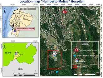
Figure 1. Study area and location of the Zaruma meteorological station
The "ZARUMA" station corresponding to the Meteorology and Hydrology National Institute (INAMHI, for its acronym in Spanish) code "M0180" is the closest to the Humberto Molina Hospital area and the San Juan Bosco school (Figure 1). The station located at the geographic coordinates of longitude -79.611390° and latitude -3.698889°, is at an altitude of 1,100 meters above sea level, approximately 600 meters from the study area.
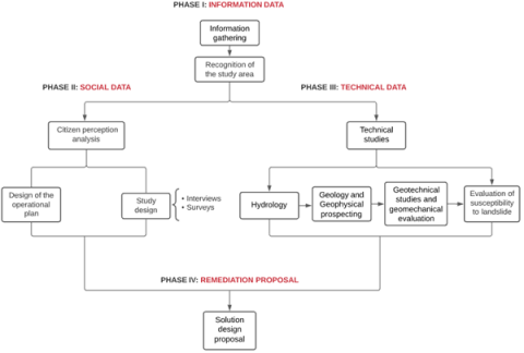
The study presents four phases of data collection and processing, which show a systematic process that allows carrying out the objective of the research (Figure 2).
3.1 First phase: Information data
Information was collected from reports, studies, and research work from different government and private entities. The base information allowed prior knowledge of the study area for the respective data collection and recognition of the area corresponding to the Humberto Molina Hospital and surrounding areas [24].
3.2 Second phase: Social data
The design of the operational plan allows to know the study area by gathering preliminary information with local authorities and with the community. 2 groups were selected to carry out the operational plan for collecting social data. Group 1 corresponds to interviewees from the Humberto Molina Hospital and the San Juan Bosco School. Group 2 corresponds to interviewees from the Zaruma parish community. The adjusted interviews for each informant allowed obtaining high response rates due to the information they could provide in experiences [25]. The interviewees (group 1) must meet specific characteristics: a) Residents in the study area; b) Their beginning of residence must be before the closure of the Hospital and c) Willingness to participate in the process. The interview questions resulted from the adaptation of the study of Schweiger et al. [26].
Surveys allow obtaining quantitative or numerical descriptions of specific aspects of the study area. A survey was designed for the two groups based on the work of Countouris et al. (2014), Mesch et al. (1999) and Pescosolido et al. [27-29]. For group 1, the survey comprises three sections related to general data, previous experiences with the Hospital and their concerns with the facilities. For group 2, the previous survey expands on patient concern and continuity of care and health issues.
3.3 Third phase: Technical data
3.3.1 Hydrology
The data period for the investigation was taken from the “ZARUMA” station, from January 1964 to December 2010, corresponding to 47 years. The World Meteorological Organization [30] recommends a period greater than 30 years to analyze hydrological studies. The data obtained from the climatological station allowed calculating of the multiannual monthly precipitation, using Eq. (1).
$P_{i}=\frac{\sum_{1}^{n} p_{i n}}{n}$ (1)
Pi = multi-year monthly precipitation (i = 1, … 12)
n = Number of years
pin = Monthly precipitation for a given year
From Eq. (1), the calculations of the different multiannual monthly mean variables were made, such as: maximum and minimum temperature, solar radiation, dew point and wind speed.
3.3.2 Geology and geophysical prospecting
The reconnaissance and field survey work made it possible to obtain data on the geology and topography of the sector. This information was vital to determine favorable locations where four electrical tomographies (Wenner configuration) and five vertical electrical soundings (Schlumberger configuration) were performed. Also, from the studies of the geophysical campaign, it was possible to establish the different layers of the subsoil from the resistivity values.
Figure 2. Flowchart of the methodology used in the study area
3.3.3 Geotechnical studies and safety factor
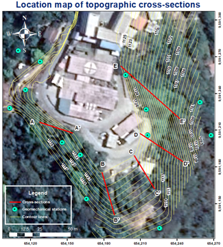
The subsoil sectors that presented low resistivity values indicated areas of interest to carry out two holes of 10 and 15 m. In addition, inside the Hospital, three pits were made just below the fractures in the ground to determine the quality and type of material present. The slope values of the terrain allowed the selection of five topographic cross-sections (Figure 3). Then, with the cohesion data, internal friction angle, specific weight, and the seismic acceleration value of Zaruma, it was possible to calculate the safety factor.
Finally, the data were processed using the Spencer method in specialized software for slope analysis, based on the limit equilibrium calculation method. Static analysis was carried out (considering only the geotechnical characteristics of the terrain and topography) and pseudo-static research (assessing the seismic activity of the study area). In addition, the seismic activity values used were those established by the Ecuadorian Construction Standard (NEC-15) [31]. According to (NEC-15), the study area is considered a zone of high seismic intensity, with a maximum ground acceleration (seismic acceleration) of 0.30 g. However, the NEC-15 recommends considering 60% of the acceleration (0.18 g) in pseudo-static analyses.
Figure 3. Location map of the topographic cross-sections in the study area and geomechanical stations
3.3.4 Evaluation of susceptibility to landslide
The procedure used in this phase consisted of a compilation of studies carried out by various experts (Ambalagán [32], Suárez [33], González [34], Nicholson [35], Blanco [36] and Sánchez [37]), where they determined parameters such as geological structure, soil quality, degree of weathering, presence of water, morphometry, vegetation cover and seismic action for evaluation of susceptibility to landslide.
16 geomechanical stations were established where values were assigned for each parameter based on the experience of the researchers in the field. After obtaining the values for each parameter, the scores were added to determine the categories according to the susceptibility's degree Table 1.
Table 1. Classification of the susceptibility to a landslide for soils
|
Susceptibility category |
Degree of susceptibility (SD) |
Observations |
|
I |
Very low susceptibility SD<5.0 |
Stable conditions |
|
II |
Low susceptibility SD between 5 and 8 |
Stable conditions. There must be monitoring |
|
III |
Median susceptibility SD between 8 and 12 |
Predominantly stable conditions. There must be systematic monitoring |
|
IV |
High susceptibility SD between 12 and 16 |
Potentially unstable conditions |
|
V |
Very high susceptibility SD>16 |
Unstable conditions |
3.4 Fourth phase: Remediation proposal
The design proposal for the rehabilitation of the Humberto Molina Hospital was prepared based on all the information and data obtained in the previous phases. Through social and technical aspects, it was possible to propose adequate remediation alternatives at a geological-geotechnical level and comprehensive solutions for the study area.
4.1 Impacts on the population
The following is a detailed gathering of the primary information of the community, local authorities, and the study area:
4.1.1 Perceptions of the inhabitants of the impact zone
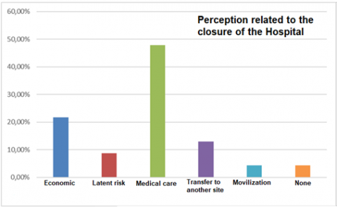
Figure 4. Result of the perceptions of the inhabitants of the area of direct impact
In the area of influence, in-depth interviews were conducted with 18 inhabitants. This made it possible to collect information on their visual expressions and experiences about Hospital activity. In general, this human group has a composition of men (44.4%) and women (55.6%), with an average age of 53.44 years, who have been residents of the area since before the Hospital's closure. The informants stated that their main problems related to the Hospital's closure are related to medical care (47.83%) and economically (21.74%) (Figure 4). Informants mentioned feeling bad, disappointed and outrage. These problems affect their perceptions and feelings related to the Hospital's closure (Figure 5). The inhabitants considered the closure of the Hospital as an error (100,00%), and it should be reopened in the same place (94.44%). In Figure 6, you can see the interviews carried out with the population of the areas surrounding the Hospital.
Figure 5. Result of citizen perceptions regarding their feelings for the closure of the Hospital
Figure 6. Meetings and interviews carried out with the people who live near the Hospital
4.1.2 Perceptions of the inhabitants of Zaruma
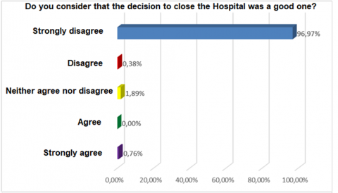
The sample of informants consisted of 264 inhabitants of the Zaruma parish. The mean age was 43.3 years, and it was composed of 43.18% men and 56.82% women. Most of them considered that the closure of the Hospital was not the right decision by government agencies (Figure 7a), and should be reopened immediately (Figure 7b). Also, 62.50% of those surveyed have indicated that the Hospital has to reopen in the same place, 30.31% near or in the same city, and others (7.19%) do not think or indicate that it should open in a nearby city.
4.1.3 Impacts on health services
Respondents consider that going to a new Hospital (Health Center) is more difficult (45.63%). However, the time taken to attend and obtain appointments to this new Hospital is the same in the order of 51.98% and 44.05%, respectively (Table 2).
At the time of closure, the Hospital had outpatient areas (Gynecology, Surgery, Internal Medicine, Pediatrics, Traumatology), Hospitalization (25 beds), obstetrics and surgery, as well as support services such as Clinical Laboratory, X-rays, ultrasound, endoscopy, rehabilitation, densitometry, and audiometry. The outpatient services had attended 11,659 users, 389 surgeries and 3,956 emergencies in the year the Hospital was closed.
(a) Do you consider that the decision to close the Hospital was a good one?
(b) Under the current circumstances, you consider that the Hospital should be?
Figure 7. Perceptions of the inhabitants of the Zaruma parish
Table 2. Access to health service
|
The experience of going to a new Hospital (Health Center) is |
Easy |
21.43% |
|
Equal |
32.94% |
|
|
More difficult |
45.63% |
|
|
The time it takes to go to a new Hospital (Health Center) is |
Less |
13.10% |
|
Equal |
51.98% |
|
|
Higher |
34.92% |
|
|
The time to get an appointment at the new Hospital (Health Center) is |
Less |
14.68% |
|
Equal |
44.05% |
|
|
Higher |
41.27% |
4.2 Physical characterization of the watershed
Climatic aspects were analyzed such as annual average maximum temperature with a value of 29.3℃, average annual minimum temperature of 17.2℃, multiannual average solar radiation with a value of 17.96 (MJ/m2/día), the average annual temperature of the point dew in the micro-basin of 19.24℃ and the value of the multiannual average wind speed of 1.98 m/s. All these variables are directly related to precipitation. The multiannual average precipitation within the 1964-2010 period (Figure 8) for the study area was 1,403 mm. Being the months of February (297.90 mm) and March (294.90 mm) are the ones with the highest rainfall, and the months of July (6.39 mm) and August (5.06 mm) with the least rainfall.
Source: [38]
Figure 8. Multiannual average by monthly precipitation (1964-2020)
4.3 Geology and geophysics
Different studies were carried out, such as topographic survey, electrical tomography, vertical electrical soundings, drilling, and pits (Figure 9), to obtain complete and comprehensive information and thus achieve the research objective. Table 3 shows the correlation of the data obtained from resistivity values in geophysics with the geology of the sector, while Figure 10 shows the correlation between a geoelectric tomography and a vertical electrical sounding.
4.4 Geotechnical and geomechanical studies
4.4.1 Drillings and soil pits
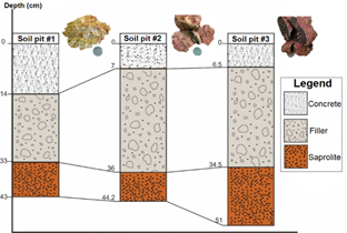
Based on the areas of interest located in the geoelectric tomographies, two drillings PZ7 and PZ8 of 10 and 15 meters, respectively (see Figure 9), were made to directly determine the lithology below the study area. Three pits were made (Figure 9 and Figure 11) inside the Hospital, determining the presence of a concrete layer, followed by a very thick filling layer and finally a layer of saprolite that varies from orange to reddish, with a granulometry fine to medium (Figure 11).
Table 3. Correlation of the results between geoelectric tomography (TGE's), vertical electrical soundings (SEV's) and geology
|
|
TGE-01-ZC |
SEV-02-ZC |
TGE-02-ZC |
SEV-05-ZC |
TGE-03-ZC |
SEV-03-ZC |
SEV-04-ZC |
TGE-04-ZC |
|
|
Depth (m) |
22 |
32 |
32 |
24 |
12 |
20 |
20 |
13 |
|
|
Resistivity (Ωm) |
>550 |
High resistivity saprolite |
High resistivity saprolite |
High resistivity saprolite |
High resistivity saprolite |
||||
|
550-220 |
Fractured saprolite |
Fractured saprolite |
Fractured saprolite |
Fractured saprolite |
|||||
|
200-80 |
Slightly saturated saprolite |
Slightly saturated saprolite |
Slightly saturated saprolite |
Slightly saturated saprolite |
|||||
|
<25 |
|
Very saturated saprolite |
Very saturated saprolite |
|
Very saturated saprolite |
||||
Figure 9. Studies carried out at the “Humberto Molina” Hospital
Figure 10. Correlation between geoelectric tomography (TGE-02-ZC) and vertical electrical soundings (SEV-05-ZC) (Figure 8)
Figure 11. Cross-section of pits in the study area
4.4.2 Safety factor
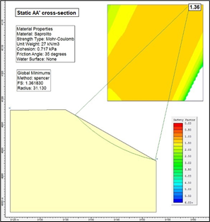
Several executions were carried out in the slope analysis software, using the five proposed cross-sections to calculate the safety factor (Figure 3). Each cross-section was analyzed under static and pseudo-static conditions (static including seismic action), applying the Spencer method and circular failure surface. The safety factors in the static analysis vary between 1.36 to 3.47 (Table 4 and Figure 12). On the other hand, the pseudo-static analysis varies between 0.95-1.81 (Table 4 and Figure 13). According to NEC-15, for a slope to be considered stable, the minimum safety factor in the static analysis is 1.50. Whereas for the pseudo-static analysis, it is 1.05.
Table 4. Security values obtained from specialized software in slope analysis
|
Analysis |
Safety factor (SF) |
||||
|
Cross-section AA' |
Cross-section BB' |
Cross-section CC' |
Cross-section DD' |
Cross-section EE' |
|
|
Static |
1.36 |
2.30 |
3.47 |
1.66 |
1.39 |
|
Pseudo-static |
0.94 |
1.41 |
1.81 |
1.09 |
0.95 |
Figure 12. Minimum safety factor by static analysis
Figure 13. Minimum safety factor of the pseudo-static analysis
4.5 Evaluation of the susceptibility to landslide
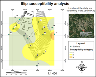
The zoning of the study sector was carried out under normal conditions and in the extreme situation in which the slope is full of water. In extreme conditions, the presence of water took the value of 4 in all the stations, changing the final value of susceptibility to landslide. Subsequently, the heat maps generated allowed to observe the behavior of the terrain according to its degree of susceptibility. A susceptibility map was obtained under normal conditions (Figure 14a), where the yellow zone represents category III, corresponding to predominantly stable conditions, where there must be systematic monitoring.
The analysis of susceptibility to landslides in extreme water saturation conditions showed an orange zone corresponding to category IV (Figure 14b). This zoning covered most of the contour lines representing potentially unstable conditions. The instability (represented by the orange color, Figure 14b) coincides with a filling material on the west side. At the same time, the instabilities that occur on the east side of the study area coincide with the values of slope and erosion recognized in the field.
(a) Normal conditions
(b) Extreme water saturation conditions
Figure 14. Landslide susceptibility map
Figure 15. Design proposal plan for rainwater control
4.6 Remediation proposals
The Humberto Molina Hospital presents problems that range from citizen perception to structural issues. Analyzing the inhabitants' perception, this was negative since they considered the Hospital's closure an error and that immediate reopening are necessary. At the same time, the inhabitants of the areas surrounding the Hospital believe that generated economic problems and medical deficits.
At the end of the surveys, interviews and technical studies, several meetings were held both with the governors of the city and the province; as well as, with the director of the Hospital (see Figure 16) to communicate the measures and solutions to be considered for the reopening of the Hospital. With this methodology, the aim is to create a space where researchers can listen to different voices, commit to disseminating them and creating spaces where they can be heard. The purpose is to highlight the problems and find solutions that lead to changes and transformations.
(a) Zaruma mayor and the El Oro province Governor
(b) Director of the Hospital
Figure 16. Meetings and interviews held to communicate and discuss the situation and measures for the Zaruma Hospital
Among the problems that the study area has, hydrology plays an essential role in analyzing the sustainability of the Hospital. Considering the Zaruma meteorological station, the precipitation values indicate directly affecting the soil's saturation and destabilization. These results coincide with the landslide susceptibility map in the maximum water saturation conditions, where it was possible to differentiate that there are potentially unstable areas. As suggested by Morante et al. (2019a), Morante, et al., (2019b) and Melentijevic, S. (2005) [39-41] indicate that for safety factors less than one, the slope is unstable. However, the susceptibility analysis under normal conditions reflected that the study area presents predominantly stable sectors, a situation proven in the safety factor calculation through static analysis.
Also, analyzing the survey of data taken in the field and the resistivity values obtained in geophysics, these sectors correspond to saprolite, a very good to medium quality material. It is vital to consider that, in the surrounding areas of the Hospital, a very weathered and poorly compacted material is present, evidenced in the perforations, the product of a filling used to expand the area of the Hospital, which in the stability analysis under pseudo-static conditions reflected a critical site. Where the slope angle decreases, the safety factor increases (Figure 17); therefore, one recommendation is to construct berms to increase the slope's safety factor and channel rainwater to reduce water infiltration.
Figure 17. Calculation of the safety factor in the pseudo-static analysis, analyzing the land on which the Humberto Molina Hospital sits and the AA' cross-section
The correlation of the results indicates that structurally, the Humberto Molina Hospital buildings present technical problems due to the adaptations carried out without previous studies that justify and verify geological and geotechnical aspects. Geological and geomechanical characteristics did not represent significant problems, but conditioning such as water management is essential for the construction of the design proposal. Another factor that is considered a trigger is the age of the construction carried out in the 70s. Geological-geotechnical studies provide a certain degree of security regarding stability if they are not aggravated by other extreme situations such as illegal mining or earthquakes of intensity not historically reported.
Many cities have developed in conjunction with mining, such as Ouro Preto (Black Gold) in Brazil, the epicentre of the gold rush and age in the 18th century. Many buildings such as churches and palaces have survived to this time, transforming into busy museums. This example, like many others, indicates that cities may coexist with mining, legal activities that involve technical studies for the well-being of the community always prevail.
The technical closure of a civil structure considers mainly technical and social aspects that must be considered in the search for a solution. In the case of the Humberto Molina Hospital, in addition to the geotechnical and structural part (almost 50 years of construction), the natural seismic phenomenon influenced the administrative closure of the hospital institution.
Surveys and interviews with citizens were considered to know their criteria of importance in decision-making that provides a solution that integrates community participation during the study. The inclusion of the population will ensure the success, commitment and sustainability of the initiatives recommended for the Hospital.
The Zaruma population considers the Hospital an emblem of safety since it represents care for thousands of people. The interviews to Zaruma inhabitants present a rejection and dissatisfaction with the Hospital's closure, affecting the health and the economy of the inhabitants. Also, the arrival of the COVID-19 pandemic further exacerbated the emergency and need for this Hospital service.
Geological studies such as topographic considerations, terrain materials, geophysical analysis, drillings, and soil pits were applied. The correlation of these results shows that the natural terrain has geomechanical characteristics to provide security to the Hospital structure.
The incidence of precipitation is directly related to the rains that fall on the Hospital, school, and surrounding areas. The average annual rainfall in the study area was 1,403 mm, so a prosecution design is needed that do not affect the building and peripheral area. Therefore, the construction of a rainwater control channel is proposed.
The investigations carried out indicate that the entire area on which the buildings are located is stable. The existence of cracks in the tiles is due to the poor uncompacted filler used in its construction. At present, for a city like Zaruma, not having Hospital services constitutes a social problem that begins with the security status of the inhabitants and affects the development and production of the place.
The study and structural analysis of the Hospital; as well as the approach to support or maintenance measures is considered as a guide for future research. This due to the age of the construction and the extensions of its blocks.
The authors acknowledge to the project "Proposal for the Ruta del Oro Geopark and its impact on territorial development" (CIPAT-02-2018) and to the Zaruma Municipality. Also, the authors acknowledge to the Hospital staff, especially to M.D. Dalton Tocto, to the CIPAT-ESPOL team and ESPOL-TECH team to carry out the project entitled "Contracting of consulting services, for the analysis of the degree of vulnerability to geodynamic risks and preparation of proposals of mitigation measures to increase security conditions in the area of the Humberto Molina Hospital in the Zaruma city, El Oro province".
[1] Tichavský, R., Jiránková, E., Fabiánová, A. (2020). Dating of mining-induced subsidence based on a combination of dendrogeomorphic methods and in situ monitoring. Engineering Geology, 272: 105650. https://doi.org/10.1016/j.enggeo.2020.105650
[2] Audisio, C., Nigrelli, G., Pasculli, A., Sciarra, N., Turconi, L. (2017). A GIS spatial analysis model for landslide hazard mapping application in alpine area. International Journal of Sustainable Development and Planning, 12(5): 883-893. https://doi.org/10.2495/SDP-V12-N5-883-893
[3] Zeng, L., Wang, B., Fan, L., Wu, J. (2016). Analyzing sustainability of Chinese mining cities using an association rule mining approach. Resources Policy, 49: 394-404. https://doi.org/10.1016/j.resourpol.2016.07.013
[4] González de Vallejo, L.I., Ferrer, M., Ortuño, L., Oteo, C. (2002). Geological Engineering. Pearson Educación. https://edisciplinas.usp.br/pluginfile.php/5540850/mod_resource/content/1/Livro%202.pdf.
[5] Bauer, R.A. (2013). Mine subsidence in Illinois: Facts for homeowners. Illinois State Geological Survey, Prairie Research Institute.
[6] Loayza Careaga, F., Vargas, I.F. (2003). Rapid socioeconomic evaluation of Chima municipality of Tipuani, department of La Paz. International Development Research Center (CODEVELOPMENT-CANADA), LA Paz, Bolivia.
[7] Mata, J., Zamora, G., Serrano, C. (2019). Risks of physical stability in the Cerro Rico of Potosí, cultural heritage of humanity. Environment and Mining Magazine, 4(1): 43-54. http://www.scielo.org.bo/scielo.php?script=sci_arttext&pid=S2519-53522019000100005&lng=es&nrm=iss.
[8] Gricelda, H.F., Paúl, C.M., Niurka, A.M. (2018). Participatory process for local development: Sustainability of water resources in rural communities: Case manglaralto-santa elena, ecuador. In Handbook of Sustainability Science and Research, 663-676. https://doi.org/10.1007/978-3-319-63007-6_41
[9] Cucari, N., Wankowicz, E., De Falco, S.E. (2019). Rural tourism and Albergo Diffuso: A case study for sustainable land-use planning. Land use policy, 82: 105-119. https://doi.org/10.1016/j.landusepol.2018.11.050
[10] Marston, A.J. (2015). Autonomy in a post-neoliberal era: Community water governance in Cochabamba, Bolivia. Geoforum, 64: 246-256. https://doi.org/10.1016/j.geoforum.2013.08.013
[11] Smith, N.M., Ali, S., Bofinger, C., Collins, N. (2016). Human health and safety in artisanal and small-scale mining: an integrated approach to risk mitigation. Journal of Cleaner Production, 129: 43-52. https://doi.org/10.1016/j.jclepro.2016.04.124
[12] USGS Earthquake Statistics Available online: https://www.statista.com/statistics/263108/global-death-toll-due-toearthquakes-%0Asince-2000/, accessed on Mar. 31, 2021.
[13] Kenny, C. (2009). Why do people die in earthquakes? The costs, benefits and institutions of disaster risk reduction in developing countries. The Costs, Benefits and Institutions of Disaster Risk Reduction in Developing Countries. World Bank Policy Research Working, 4823.
[14] Anelli, A., Santa-Cruz, S., Vona, M., Tarque, N., Laterza, M. (2019). A proactive and resilient seismic risk mitigation strategy for existing school buildings. Structure and Infrastructure Engineering, 15(2): 137-151. https://doi.org/10.1080/15732479.2018.1527373
[15] Di, B., Li, J., Dandoulaki, M., Cruz, A.M., Zhang, R., Niu, Z. (2020). Household recovery strategies in Longmen Mountain area, Sichuan, China, following the 2008 Wenchuan earthquake disaster. Natural Hazards, 104(1): 123-137. 10.1007/s11069-020-04287-z
[16] Rawat, M.S., Joshi, V., Uniyal, D.P., Rawat, B.S. (2016). Investigation of hill slope stability and mitigation measures in Sikkim Himalaya. International Journal of Landslide and Environment, 3(1-3): 8-15.
[17] Gordo, C., Zêzere, J.L., Marques, R. (2019). Landslide susceptibility assessment at the basin scale for rainfall-and earthquake-triggered shallow slides. Geosciences, 9(6): 268. https://doi.org/10.3390/geosciences9060268
[18] Duan, L., Xiang, M., Yang, J., Wei, X., Wang, C. (2020). Dynamics and change features of the eco-environment restoration in the worst hit area of a strong earthquake. Planning, 15(6): 819-825. https://doi.org/10.18280/ijsdp.150604
[19] Gardner, J.S., Dekens, J. (2007). Mountain hazards and the resilience of social–ecological systems: Lessons learned in India and Canada. Natural Hazards, 41(2): 317-336. https://doi.org/10.1007/s11069-006-9038-5
[20] Aguilar, M., Torrens, R.B., Bernal, C.B., Bitar, J.B., Mero, P.C., Carballo, F.M. (2019). Geomechanical characterization and analysis of the rock mass' s affectations in the urban area of Zaruma, Ecuador. In Proceedings of the 17th LACCEI International Multi-Conference for Engineering, Education, and Technology: “Industry, Innovation, and Infrastructure for Sustainable Cities and Communities”, Montego Bay, Jamaica, 24-26. https://doi.org/10.18687/LACCEI2019.1.1.362
[21] Herrera Franco, G., Carrion Mero, P., Morante Carballo, F., Herrera Narváez, G., Briones Bitar, J., Blanco Torrens, R. (2020). Strategies for the development of the value of the mining-industrial heritage of the Zaruma-Portovelo, ecuador, in the context of a geopark project. International Journal of Energy Production and Management, 5(1): 48-59. https://doi.org/10.2495/EQ-V5-N1-48-59
[22] Paucar, E. (2017). 59 kilometers of galleries cross the Zaruma's bowels. El Comercio. https://www.elcomercio.com/actualidad/zaruma-galerias-mineria-oro-estadodeexcepcion.html, accessed on Nov. 11, 2019.
[23] La historia. (2019). Bureaucracy keeps Zaruma Hospital closed. https://www.lahistoria.ec/2019/06/24/burocracia-mantiene-cerrado-el-Hospital-de-zaruma/, accessed on Aug. 3, 2021.
[24] Carrión-Mero, P., Solórzano, J., Chávez, M.Á., Blanco, R., Morante-Carballo, F., Aguilar, M., Briones-Bitar, J. (2020). Evaluation of geomechanical features and stability for the recommendations and rehabilitation of the Humberto Molina Hospital, Zaruma, El Oro, Ecuador. Sustainable Development and Planning XI.; WIT Press: Ashurst, UK, 1: 455-466. https://doi.org/10.2495/SDP200371
[25] Sarstedt, M., Mooi, E. (2014). A concise guide to market research. The Process, Data, and Methods Using IBM SPSS Statistics, 12. https://doi.org/10.1007/978-3-642-53965-7
[26] Schweiger, D.M., Ivancevich, J.M., Power, F.R. (1987). Executive actions for managing human resources before and after acquisition. Academy of Management Perspectives, 1(2): 127-138. https://doi.org/10.5465/ame.1987.4275830
[27] Countouris, M., Gilmore, S., Yonas, M. (2014). Exploring the impact of a community hospital closure on older adults: A focus group study. Health & Place, 26: 143-148. https://doi.org/10.1016/j.healthplace.2013.11.008
[28] Mesch, D.J., McGrew, J.H., Pescosolido, B.A., Haugh, D.F. (1999). The effects of hospital closure on mental health workers: An overview of employment, mental and physical health, and attitudinal outcomes. The Journal of Behavioral Health Services & Research, 26(3): 305-317. https://doi.org/10.1007/BF02287275
[29] Pescosolido, B.A., Wright, E.R., Kikuzawa, S. (1999). “Stakeholder” attitudes over time toward the closing of a state hospital. The Journal of Behavioral Health Services & Research, 26(3): 318-328. https://doi.org/10.1007/BF02287276
[30] OMM. (2011). Hydrological Practices Guide. Volume II. Management of Water Resources and Application of Hydrological Practices. OMM-No. 168. Sixth edition. https://library.wmo.int/doc_num.php?explnum_id=10038.
[31] MIDUVI. NEC's chapters (Ecuadorian Construction Standard). https://www.habitatyvivienda.gob.ec/documentos-normativos-nec-norma-ecuatoriana-de-la-construccion/, accessed on Mar. 29, 2021.
[32] Anbalagan, R. (1992). Terrain evaluation and landslide hazard zonation for environmental regeneration and land use planning in mountainous terrain. In International symposium on landslides, 861-868.
[33] Suárez, J. (1998). Landslides and slope stability in Tropical Zones. Research Institute on Erosion and Landslides, 1: 550. https://www.erosion.com.co/deslizamientos-y-estabilidad-de-taludes-en-zonas-tropicales/.
[34] Gonzalez, A.J. (1989). Methodology and classification criteria for movement inventory. In I South American Landslide Symposium. Colombian Society of Geotechnics, Paipa-Colombia, 677-698.
[35] Nicholson, D.T.; Hencher, S. (1997). Assesment the potential for deterioration of engineered Rock Slopes. In Proceedings of the International Symposium of Engineering and the Environment, Athens, Greece, 911-917.
[36] Carrión-Mero, P., Briones-Bitar, J., Morante-Carballo, F., Stay-Coello, D., Blanco-Torrens, R., Berrezueta, E. (2021). Evaluation of slope stability in an urban area as a basis for territorial planning: A case study. Applied Sciences, 11(11): 5013. https://doi.org/10.3390/app11115013
[37] Carrión-Mero, P., Aguilar-Aguilar, M., Morante-Carballo, F., Domínguez-Cuesta, M.J., Sánchez-Padilla, C., Sánchez-Zambrano, A., Berrezueta, E. (2021). Surface and underground geomechanical characterization of an area affected by instability phenomena in zaruma mining zone (Ecuador). Sustainability, 13(6): 3272. https://doi.org/10.3390/su13063272
[38] Monto, N.C.O. (2013). National Institute of Meteorology and Hydrology. https://www.inamhi.gob.ec/biblioteca/ accessed on Mar. 29, 2021.
[39] Morante, F., Aguilar, M., Ramírez, G., Blanco, R., Carrión, P., Briones, J., Berrezueta, E. (2019). Evaluation of slope stability considering the preservation of the general patrimonial cemetery of Guayaquil, Ecuador. Geosciences, 9(3): 103. https://doi.org/10.3390/geosciences9030103
[40] Carballo, F.M., Mero, P.C., Chávez, M.Á., Aguilar, M. (2019). Design of the stabilization solutions in the general patrimonial cemetery of Guayaquil, Ecuador. In Proceedings of the 17th LACCEI International Multi-Conference for Engineering, Education and Technology. https://doi.org/10.18687/LACCEI2019.1.1.368
[41] Melentijevic, S. (2005). Stability of slopes in rock masses with non-linear failure criteria and unassociated creep laws. Doctoral Dissertation, Caminos. https://oa.upm.es/722/1/04200507.pdf.