Karen Andersen Cirera
© 2022 IIETA. This article is published by IIETA and is licensed under the CC BY 4.0 license (http://creativecommons.org/licenses/by/4.0/).
OPEN ACCESS
This paper seeks to evaluate the public space potential of riverbanks in the case of the city of Valdivia. The main goal of this research is to understand the relationships that promote or hinder the equitable enjoyment of watercourses and riverbanks. In the case of river access, spatial equity will be considered as the possibility for all inhabitants to access the benefits and resources of the river in their daily lives. Different analytical techniques and quantitative data were used to explore the relationships between socioeconomic characteristics, like socioeconomic groups and land value in the riverbank urban area. This evaluation will be applied by river edge transects. This article is a contribution to the theoretical discussion of social equity in urban riverfronts as an application in the case study since there are few studies on river banks from this perspective. Lack of a comprehensive shore planning in waterfront neighborhoods and of diverse public spaces impedes due public riverside and water use, as well as neglects ecological deterioration processes and social vulnerability.
public space, waterfronts, riverbank, spatial equity, accessibility
Riverside public space projects have driven reflection regarding the relation between nature and cities. Urban rivers have gone from being seen as resources for navigability and water supplies to being valued as urban services and valuable ecosystems. The diversification of public space typologies and the incorporation of the value of nature in the city can be seen early on in the Parisian hygiene projects of the 19th century, which sought to regenerate degraded riverbank zones by creating large green spaces. These actions diversified the types of open spaces, with the addition of green plazas, gardens, urban parks, suburban or peri-urban parks and natural reserves [1]. Urban naturalization was a phenomenon in both Europe and North America in the 19th century, along with the rise of studies associating positive values through out greater contact with nature. It simultaneously operated as a way to transform morally and physically degraded environments impacted by the processes of industrialization.
Ecological restoration of natural systems lies within the concerns of 20th century urban planning, which witnessed urban growth and the subsequent degradation of quality of life and the environment due to globalization [2]. Some terms related with ecological restauration are recovery, enhancement or ecological rehabilitation [3].
It has been understood as a redemptive practice for a failed relationship between human and nature. The two goals of ecological restoration seen by professionals in the field, are “on the one hand, some respondents focused on safe- guarding biodiversity and conserving threatened species, while on the other hand, some focused on preserving naturalness and restoring the well-functioning of ecosystem processes” [4].
This ecosystem restructuring via creating parks and environmental corridors is notable in the London Plan of Leslie Patrick Abercrombie which in 1944 incorporated the concept of a Green Belt, as well as in the 1947 Copenhagen Plan which proposed a growth pattern in the shape of five fingers, respecting the natural environment. Rivers are an example of the potential of connection and the wealth of ecosystems that can be generated in linear or continuous parks.
These postulates are also picked up under New Urbanism, a trend arising in late 20th century North America based on critiques of the urban model growing along with the following abandonment and destruction of historic downtowns [5, 6]. New urbanism advocates for mixed neighborhoods, with public spaces that promote various types of interactions. This idea supposes a promotion of diversity of types of public spaces, based on the particularities of each place and users, as a critique of shopping mall culture of the American suburbs [7].
This movement advocates an urban model at human scales, promoting access to public spaces and urban services as well as walkable and lively environments, based on the idea that the design of the built environment impacts happiness, community creation and urban health [8]. In this context, the sustainable urban development paradigm arose, representing a hybrid concept with the goal of jointly contributing to social welfare, ecological integration and economic development [9].
The scientific literature, both from the social and environmental sciences, has focused on green solutions to face the problem of planetary urbanization. On the side of urban practice and urban policies, green solutions have been used as a key strategy for urban renewal and in the development of sustainable city agendas [10]. Green solutions as a resource for sustainable urban development has been theorized and put into practice, coining various concepts which give a role and an urban function to nature. Three of the most used concepts are urban ecosystem services, urban green infrastructure and nature-based solutions [11]. These focuses see in the protection and valuing of nature, whether pre-existing or created within urban environments, a strong point for sustainable development, while not necessarily being critical regarding issues of inclusion and socio-spatial justice [10].
In the case of cities on shorelines and riverbanks, the challenge of equity which urban development along these limits must face is peculiar to each city. The history of urban fabric, land use, and the functionality of the river defines particular equity challenges in each city. However, some discourses regarding the way to relate cities with water boundaries has achieved cross-sectional permeation in the urban histories of many cities across Western civilization.
This study aims to evaluate how the accessibility to the riverbank in the city of Valvidia defines a relationship of equity and inclusion. We postulate that the urban growth and the lack of waterfront planning for the city has generated fragmented riverside spaces, due to their low accessibility and diversity index. We also postulate that urban fabric impact environmental, social and economic sustainability along urban riverbanks. To verify this hypothesis, we will evaluate equity and riverfront access. For this study, accessibility and diversity indicators of the urban river edge of the city of Valdivia will be measured. The expected results will seek to answer which factors and urban conditions affect equitable enjoyment of waterways.
This article is developed in five chapters. The first chapter, is the introduction to the content of the article. The second chapter is a literature review, that develops a theoretical framework of relations between city and river, going into the social sustainability focus for these relations, to define the inclusion and equity principles to be evaluated in a case study. The third chapter, methods and materials, provides information on the case study being evaluated, via a characterization of the historical relation of Valdivia with its river. This third chapter also introduce the concepts and measurement methods of accessibility and diversity of urban riverfront. The fourth chapter, results and discussion, evaluates how the city of Valdivia currently relates with its riverbanks, studying existing accesses, land uses and socioeconomic groups living in the urban area of direct riverine influence. Finally, the article in the last chapter of conclusion, describes the deficiencies and limitations of the study, and how the results are a contribution to discipline.
2.1 A history of city-river relations
Urban waterfront spaces have been used for various functions, as both a resource and a medium. These two functions have been used for public and private ends, creating various types of waterfronts and water-city relations. Rivers were key to human settlement, being used for extracting organic and mineral resources, for drinking water supplies, for irrigation and energy, and as a means for transporting products and people via navigation. While these functions have been key to urban development, they have brought water pollution as well as privatization of waterfronts. Between the mid-18th century and the 20th century many rivers suffered morphological changes, being channeled via major engineering works, with some being straightened, shortened, flanked with dikes or buried. This loss of urban rivers’ natural function in the hydrological and ecological areas has been associated with increased risk for populations, as well as biodiversity erosion [12-14]. While fully returning urban rivers to their natural state is generally impossible, recent decades’ efforts have been centered on appropriating rivers for urban life.
Urban riverbank revitalization projects have been a major cause for concern in cities since the 1960s, the point at which the vocation of many urban waterfronts changed due to industrial and shipping functions moving away from city centers. These projects’ purposes are social, economic and (in recent years) environmental, conditioning the definition and transformation of these zones via projects for public recreational spaces, new neighborhoods and natural reserves [15-18]. Vitality and equity in open spaces are some of the project objectives, which by their marginal location or perhaps because of their original functions’ displacement has left undefined zones which tend to become abandoned and vacant lots or terrain vagues [19]. Changes in rivers’ economic functions opened new possibilities for other, less ecologically demanding uses. Urban parks are the main new use given to urban riverbanks, with various projects including shin-sui or playing with water parks in Japan, beaches and recreational shorelines. The other movement which arises is ecological restoration of rivers, including reforestation, restoring river wetlands, dike removal and river canal redesign [14]. River Culture is a focus present in the UNESCO Letter “Rivers and Heritage” which seeks harmonious coexistence between humans and rivers, recognizing an ontological relation between human wellbeing and proper ecological functioning [12].
2.2 Urban riverfronts: A sustainability approach to equity and public access
In a sustainable focus, urban rivers fulfill an essential function, providing both water and biodiversity resources. Sustainability indicators associated with water are principally indicators for stress on hydrological, ecological and risk systems associated with settlements. However, river sustainability includes its social and economic value, apart from its ecological value. Wu et al. [20] define five inherent concepts of river sustainability, which can be worked through at various scales. These perspectives are (1) resource sufficiency and quality to maintain ecological health, (2) resilience, as a skill to absorb changes, (3) access in the form of communities’ right to access river services, (4) productivity in the form of resources for socioeconomic development and (5) equity in the distribution of benefits and disadvantages in river system use.
The discussion of sustainability by David Throsby [21] refers to maintaining the enduring qualities of phenomena out of concern for the self-generating or self-perpetuating characteristics of a system. Setha Low et al. [22] define the concept of social sustainability as one which seeks the maintenance and improvement of diversity in the stories, values and relations of contemporary populations. Low develops three critical dimensions of social sustainability: preservation of place, social ecology and cultural diversity. A review of literature about urban social sustainability done by Dempsey et al. [23] considers physical and non-physical factors which contribute to it. The physical factors they mentioned include urbanity, attractive public spaces, decent housing, environmental quality, service accessibility, equipment and green areas, sustainable urban development and walkable neighborhoods. City residents need equitable access to these social sustainability factors [23]. Spatial equity is based on social and distributive justice and equality of conditions. When equity is measured, accessibility is one of its indicators and a tool for measure if equity is or isn’t achieved [24].
Accessibility seen like a way to achieved equity, is based in different aspects, like distances, travel models, and social barriers [24]. Spatial equity is affected via discriminatory practices against accessing services and participating in urban life, excluding certain groups. At the urban planning and design level, this exclusion manifests in practices and designs disincentivizing certain uses of space, by privatization or excessive control of public spaces and by residential segregation. By residential segregation we refer to the degree to which two or more groups live separately, concentrating poverty [25]. Some causes of spatial inequity include land value deregulation, high land values and the subsequent homogeneity of real estate supply in some neighborhoods with access to quality urban living benefits. Territorial policies directly affect wealth polarization.
Texts about sustainability highlight the importance of social diversity as a principle for promoting spatial equity, where all social groups have equal access to basic services and resources [22, 26, 27] Emily Talen mentions how the policies of socioeconomic group mixing in the USA began in the 19th century with the explicit objective of building a fair city [8]. For this author, social diversity fosters vitality and spatial equity. On the other hand, varying land uses promotes the nodal nature of public spaces and reinforces its use by people from beyond the neighborhood, thereby promoting equity in their access [27].
There is an amount of research of the notion of equity that focus on the geographical distribution of public services and facilities in the cities [28, 29], but when the facilities are determined by geography and hydrology, as is the case of river cities, the question is how the urban fabric and the build environment develop along the rivers.
Regarding riverfront access, spatial equity will be considered as the possibility for all inhabitants to access the benefits and resources of the river in their daily lives. However, the city-river relationship defines these spaces’ perceptions, and they can be considered resources or as problems for urban life. Designing spaces for public use in these areas contributes in a twofold sense: As civic spaces open to a wide range of users that can also transform the negative perception which frequently arises about indeterminate border spaces which constitute barriers, into spaces for urban connectivity and social interaction. Thus, the presence of diverse people and interests, along with interaction and connectivity between them make up factors for spatial equity. Public spaces, as containers of social, economic, and symbolic dynamics, reflect social sustainability in a city. If we look over the river edge neighborhoods, a high socioeconomic diversity index in homes with walkable river access would be a spatial equity criterion, along with riverside spaces which provide a diverse range of activities that can encourage engagement by diverse users.
Promoting accessibility to the river for people is one way of integrating urban life with the river, encouraging environmental protection and river vitality. Connectivity as an urban design goal from various perspectives is a principal way to promote urban vitality [27, 30]. From the perspective of ecology and landscape, rivers are naturally connective spaces between different habitats. Rivers and their banks are connecting elements from their sources to their mouths. From the cultural perspective, when rivers cross cities, connectivity incorporates human habitat and its activities [31]. Promoting public accessibility to urban riverbanks increases protection for natural habitats, impeding intervention in these areas for private goals. Thus, access equity is a factor which promotes ecological conservation.
The concept of rivers’ social connectivity [32] is essential for understanding riverbank access, since it addresses the associated social uses. This focus borrowed from environmental sciences considers both longitudinal, lateral and vertical connectivity. River used for transportation and navigation have privileged longitudinal connectivity over lateral connectivity. Regarding connectivity along urban riverbanks, these have favored the form of urban waterfronts as a containment system for the river and as a privileged access point to the water [32]. Lateral connectivity is often mediated by a vertical relation due to the typical topography of river basins, which impedes pedestrian accesses and favors construction that makes the most of scenic views [31, 33]. However, these can be versatile spaces which give rise to multiple uses of the river. Thus, riverside spatial morphology can support a range of activities which strengthen user and interest diversity, via these spaces’ versatility. The variety of spaces and access is conditioned in part by the morphology of the river and the valley [34]. Another factor that determines the variety and character of the riverside spaces is the history of the city
Exclusion from access to nature takes various forms. First, there is a tendency to privatize the enjoyment of nature or ecosystem services via creating nature which is exclusive for certain areas with restricted access. The same phenomenon arises in urban development for wealthy socioeconomic groups along ocean coastlines and along riverbanks. Second, regarding green infrastructure projects, there is not necessarily any association with a balance of their concomitant socioeconomic effects. This balance is key for achieving equity in interventions and controlling the effects of population displacement arising from increased neighborhood land values [10]. Third, regulations regarding lands around coastlines and rivers have problems with protecting their quality of a national public-use good in the strict sense of permitting their use and enjoyment by the whole society. This is due to a series of legal exceptions and sectorial superimpositions in their administration [35]. This final reason makes many spaces alongside rivers, lakes and oceans lack public access due to various legal reasons which protect private interests, such as concessions or benefits granted by property subdivisions.
3.1 Case study: Valdivia, a riverside city in flux
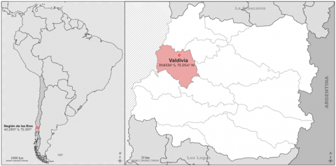
The city of Valdivia is a medium-sized Chilean city, with a population of 166,080 according to the last Census in 2017. It is located at 39° 48' S, 73° 14' W, specifically within the Valdivia River hydrographic basin, at the intersection of the Calle Calle, Valdivia, Cau Cau and Cruces rivers (Figure 1). The urban forms associated to the use of riverbanks throughout the history of Valdivia and the natural disasters suffered by the city have defined the river-city relationship. This relationship with water has molded the identity of Valdivia, marked by an intense relation of use among inhabitants, principally associated with navigability which drove industrial and commercial development in the city. The riverine landscapes of Valdivia have hosted settlements since the pre-Hispanic period. Settlements have been built, destroyed and rebuild in this area following invasions, fires and earthquakes.
The first indigenous Huilliche and Mapuche populations benefited from the rivers’ navigability by settling along the riverbanks, where commercial trade and supply markets took place [36]. The fact that these rivers were near the ocean and had high water flow volumes led to the founding of the colonial city on this strategic location in 1552 [37]. The 16th and 17th centuries were marked by intense shipping traffic from the port of Valdivia, mainly exporting wood as a raw material [38]. The arrival of Dutch ships in 1643 led to the fortification of the bay two years later, and ultimately the re-foundation of the city behind defensive walls, transforming the port into one of the most heavily protected sites in southern Chile. This lasted only until the attack of patriot armies during the War of Independence, and the arrival of the new Republic to the city in 1820. Based on this change, the city fell into an economic crisis which lasted until the period of Industrial Development which arose based on the colonization law of 1845 [39]. German colonial settlers drove innovations in farming, forestry and early industry in Chile. Shipyards were an important part of this development, which led to intense river transportation and efficient distribution of industrial products. The peak of Valdivian industry, between 1870 and 1914, was characterized by the river constituting a key element as a transportation path for products to enter and leave the interior of the region via the port of Corral which allowed exportation towards the rest of the country and abroad, even before the railroad came [35]. While rivers were a key element in the economic development of the city, that urban origin arose further inland and not closer to the riverbanks [40].
The Second World War, along with the Chilean state adopting the import substitution industrialization model, brought a new economic crisis to the city. In May 1960, this declining industry faced an earthquake of immense magnitude, which along with the overflow of Lake Riñihue destroyed industrial and port infrastructure and transformed the geography of the city [41]. We can sustain that the intensity of the relations which the city has established throughout its history with its rivers marks its urban identity and has been key for the urban development of the city. However, development has also been marked by the poor quality of building sites and living memory of the floods and catastrophes which mainly destroyed the riverbanks around the city, which has driven urban growth towards the interior [42].
Valdivia, like many intermediate Chilean cities, is growing fragmented and dispersed in the territory, towards peri-central and peripheral areas, as a result of urban planning that tends to eliminate urban boundaries [43, 44].
Nowadays, the riverbanks of Valdivia are mainly destined for the tourist industry and water sports. At the same time, they become attractive for real estate projects, with a consequent privatization of the banks.
Valdivia is characterized by extensive wetland areas within the city and along river margins, which are fragile environments heavily pressured by urban development [44]. Regarding public use of river corridor, fluvial transport has lost its leading role to terrestrial routes, and part of the mobility was replaced by bridges. Public spaces are associated with central areas of the city and being almost non-existent or informal towards the suburbs. The principal activities of this central public spaces today are tourism, market and walks. The public market, continues to use the same type of place as in the pre-Hispanic period and is a cultural heritage site for the city, placed along the embankment in the center of the city [36, 45].
In the last decade, public investment has grown in public spaces along riverbanks, as well as in the regeneration of deteriorating riverside neighborhoods.
Figure 1. City of Valdivia, Chile
3.2 Accessibility and social diversity assessment methodology
This article will focus on the urban scale to evaluate the public space potential of riversides in the case of the city of Valdivia through the evaluation of river accessibility, land use diversity and their relation to socioeconomics characteristics.
Different analytical techniques and quantitative data were used to explore the relationships between socioeconomic characteristics, like socioeconomic groups and land value in the riverbank urban area.
We used a cartographic method, based in visual analysis and interpretation of quantitative data resulting from the measurement of specific indicators. We will use ArcGIS software to measure and represent the data. The indicators were measured by transects based on georeferenced morphological and social information about the entire urban margin with direct influence on the Calle-Calle, Valdivia, Cau-Cau and Cruces Rivers.
Separate evaluations will be done on 6 riverside transects with direct influence from the contiguous rivers. These transects are associated with types of urban development and certain homogenous traits (Figure 2).
T.1_ East bank of the Valdivia River, from the southwestern city limit to San Carlos Street. Neighborhoods: Guacamayo, Barrios Bajos.
T.2_ East and south banks of the Calle-Calle River, from San Carlos Street to the Calle-Calle Bridge. Neighborhoods: Historic downtown, Estación.
T.3_ South bank of the Calle-Calle River, from the Calle-Calle Bridge to the eastern city limit. Neighborhood: Collico.
T. 4_ Northern bank of the Calle-Calle and Cau-Cau River. Neighborhood: Las Animas.
T.5_ Banks of the Calle-Calle, Cau-Cau and Cruces Rivers. Neighborhood: Isla Teja.
T. 6_ Northwestern bank of the Valdivia River and western bank of the Cruces River. Section covers the seaward extension of the city crossing the Cruces River.
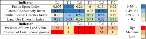
The indictors we measured were the land use diversity, a riverside public space index, and the number of access points to the riverbank and to water, via the creation of a lateral connectivity index and a public pier and beach index. There will also be cartographical visualizations of the information by block regarding the distribution of socioeconomic groups and land value. In order to analyse the quantitative information, a qualitative field observation method was carried out (Table 1).
3.2.1 Accessibility evaluation methodology
By accessibility we understand the capacity of the urban fabric to allow inhabitants and people in general to reach and make recreational use of the riverbanks. To measure accessibility in the context of Valdivia, we consider as indicators the existence of public spaces, roads, beaches or infrastructure to access water such as docks.
The concept of accessibility was originally defined as a continuous variable that is measured by the relation between activities available at a given distance and travel time [46, 47], and the possibility to increase opportunities to access to services and different activities [48]. Other authors have incorporated variables of spatial opening, visual corridor, ecological continuity and amenities, to evaluate public accessibility to the riverfront [49].
Figure 2. Transect map
Table 1. Methods by indicator
|
Urban Quality |
Indicator |
Method |
|
ACCESIBILITY |
Public Space Index |
PSi= ∑PS/ LS |
|
Lateral Connectivity Index |
LCi = 400/Me. |
|
|
Public Piers Index |
PPi= ∑PP/ ∑SP |
|
|
SOCIAL DIVERSITY |
Land Use Diversity Index |
LVDi = 1-∑ n (n-1) |
|
Land Value Diversity Index |
LUDi = 1-∑ n (n-1) |
|
|
Presence of Low Income groups |
Cartography |
In this article, riverfront accessibility is defined as the possible to access to the use and enjoy of the fluvial landscape, to recreate by the water and using the river for bathing or navigation. However, this index does not consider a qualitative assessment of accessibility by transect.
In the objective of seeking to understand spatial equity, we measure three indicators. The first is a Public Space Index (PSi) calculated with the relation between linear shoreline meters with formal public spaces (PS) and the total length of the section evaluated (TS).
PSi=∑PS/TS
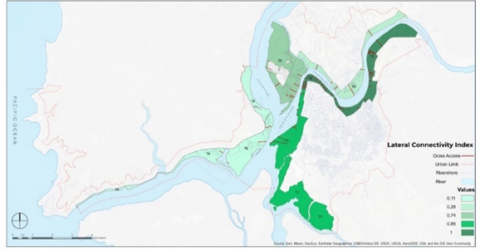
The second accessibility indicator is the Lateral Connectivity Index for the river. To calculate this, we record accesses from urban areas towards the riverside, considering pedestrian or vehicular streets which allow access to the waterfront. The median distance of longitudinal stretches to the river between access points is calculated (Me). For the index, walkable distances of 400 meters are divided by the median, when this is over 400 m. When the median is ≤400 m, the index is 1.
LCi=400/Me
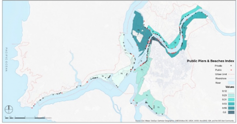
The third indicator is the Public Piers/Beach Index. We recorded the number of piers and indicate their river access property. The index is calculated dividing the total number of public piers (PP) by the overall number of piers along the section (SP).
PPi=∑PP/∑SP
3.2.2 Diversity evaluation methodology
How to promote diversity is an old and extended discussion in urban studies. Its main objective has been to fight against urban segregation. This was shown very well by the criticism of planning of the latter half of the twentieth century in North America, by Jane Jacobs in her book The Death and Life of Great American Cities [5]. Talen [50] uses the term place diversity to describe a normative view that concerns all forms of social and economic mixing, and not just racial integration, as has been usually studied.
This study considers the measurement of only some aspects of diversity. We will focus on land use and its socioeconomic characteristics. Land used diversity is an essential aspect for economic vitality and livability. In other hand, socially diverse neighborhoods are essential for the goals of social equity.
We measured the Land Use Diversity Index, and the cartographic analysis of the distribution of socio-economic group and land value information. Land value information (n) is based on fiscal appraisal for homes, information available from the Chilean Internal Revenue Service. The methodology to calculate Land Use Diversity Index uses the Simpson diversity index calculation formula and is calculated by section.
Land use information (n) is recorded on location by lot.
LUDi=1-∑n(n-1)
The possibility of accessing the rivers from the urban areas of Valdivia is principally via formalized urban riverfront walks, concentrated along two of the study transects (2 and 3). These transects have also good lateral connectivity. In relation to the public space index we can observe that it is very low, being the only section that has an absolute index the section 1 that corresponds to the center of the city, the well-known urban riverfront walk of Valdivia. All the other stretches have an index lower than 0.3. This transect also coincides with high land values predominating. Regarding land uses, these are the sections with the most commercial and service uses. Regarding land use diversity, this value is not very high, with a high number only in the more central sector (Transect 2). This condition makes these places’ attraction lie principally in the range of activities in public space, as well as its possibilities for accessing water or relating to the fluvial landscape. In the central section, land use diversity does not consider the temporary uses of amenities that are installed in public space, including varied commercial uses as well as tourism and recreation services. However, this activity supply diversity does not exist in any other transect (Table 2).
Regarding transect 2, its central condition and the shape of its urban path makes it the most heavily used space of the Valdivia urban riverfront, concentrating the highest lateral connectivity index. This section, which is a historic public space for the city, has been a continuous focus for improvement and renovation projects (Figure 5).
In relation to the lateral connectivity index, it can be seen that except for sections 4 and 6 all the sections have good lateral connectivity, the issue here lies in the quality of these connections, most of them being spaces of very low quality and vitality. As well as poor connectivity between them. In relation to the index of piers and public beaches, it is observed that in almost all the sections it is very low, being the highest 0.6, in section 2, corresponding also to the center of the city.
In relation to the diversity of land uses, this is also low in all the sections, however when we read it together with the land uses, it is observed that the existing diversity in all the sections except the section of the center of the city, corresponds to the presence of large agricultural, industrial and uninhabited properties, so this diversity is not necessarily associated with vitality or social diversity of the border.
Regarding access equity, inequality can be observed in the relation of adjacent residential neighborhoods with the river. We can observe how in the sections with a higher presence of low-income groups, there are fewer riverside accesses, as well as fewer public piers and beaches, by contrast with higher socio-economic neighborhoods which apart from having more public access infrastructure, also have privatized riverside spaces, characterized by a greater number of private lateral accesses and private piers. The transect 1 is the only one that have a high presence of low-income groups and a good index of public piers and beaches. However, this transect has also one of the lower public space indexes, having little surface of public spaces.
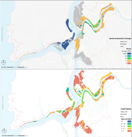
The land value map shows how the riverbanks are associated with high value residential lots, corresponding to the smaller plots in the central sectors of the city, along with large industrial or undeveloped lots that, given their size, have a cheaper m2 value. The distribution plan of socioeconomic groups shows how the river border concentrates higher groups towards the western edge and lower socioeconomic groups towards the eastern and south edge, creating a clear segregation of wealthy neighborhoods (Figure 3).
Table 2. Evaluation by transects
Figure 3. Socioeconomic groups map and land value map
4.1 Effects of the urban fabric on accessibility and access equity
The high presence of vacant lots, as well as large sites with productive uses, explain in part, the high and medium presence of low land values in the riverside. In the case of section 6, we can see that the urbanized sites are closed condominiums meant for high socioeconomic groups, with little presence of low-income populations. The city has grown in a disorganized style along the riverbanks which cross the city and along urban roadways. This “riverine urban edge” is characterized by a sum of residential developments and large industrial, vacant and farming lots which persist along the historical riverside path. The urban sprawl morphology of the residential areas is conceived like isolated and low-density units, for homogenous socioeconomic groups and a large presence of cul de sac streets. This urban development along the riverbanks has poor connectivity to the city. In the case of sections 3, 4 and 6 the access is by an interurban route. This unplanned growth is also characterized by a poor endowment of basic amenities along these riverfront zones.
This effect of the urban area impacts river accessibility, since it corresponds to access through minor streets, often primarily vehicular. Furthermore, given the predominant land structure in these sectors, these streets with lateral connectivity lack vitality, with a predominance of façades with blind delimitations and vacant lots, agricultural fields or industrial spaces with large lot areas. These accesses’ visibility is deficient, as there is little connection with other urban nodes. The piers present in these sections are also sporadic river accesses.
Another effect of the urban fabric is fragmentation and segregation. The new models of urban development present in sections 3, 4 y 6, characterized by closed and exclusive residential neighborhoods or open neighborhoods by adopting the urban form of a gated communities. These neighborhoods have public spaces fomenting exclusivity in use by neighborhood residents via accesses controlled by a single street, exclusive recreational areas, and security systems. These groups also correspond to urban pieces fragmented from the rest of the riverside, with low longitudinal connectivity, since they are real estate developments on a lot structure based on large agricultural or industrial sites with great depth. These neighborhoods are extensions with homogenous living solutions, considered for a single socioeconomic and family group, which does not promote social mixing. The public access is just as exclusionary as the real estate supply, due to the privatization of spaces and accesses in the case of co-owned closed condominiums, or public spaces lacking in vitality due to the low diversity of land use within these neighborhoods, which disincentivizes their use by non-resident people, thereby generating another factor for inequity in river access.
By contrast, regarding the more central lots associated with historic city neighborhoods, transects 1 and 2, the increase of density and smaller block size allows for more land use diversity and lateral connectivity. Riverfront access spaces associated with smaller blocks and lots with longitudinal public space along the river, as in the case of the riverfront sections in transects 1 and 2 or some residential shorelines on the sector of Isla Teja in section 5, have better lateral connectivity. The central condition of these spaces along with diverse land uses foments spatial equity in access. Larger public spaces also promote broader space usage. These spaces coincide with the spaces with adequate urban design for public use.
4.2 The impact of riverfront privatization on longitudinal connectivity and access equity
The privatization of the Valdivia riverfront is clearly observed in the low public space index of five of the six sections (Figure 4). However, we must evaluate the character of the non-privatized spaces. In this section there is an overlap between publicly accessibly recreational spaces and natural areas without established public accesses. In this sense, section 5, corresponding to Isla Teja, has the highest index of publicly accessible spaces, considering that almost half the island shoreline is a private park open to the general public belonging to the university campus of Universidad Austral de Chile.
Access to river connectivity via piers is another activity which seems to be exclusive to certain groups, since the percentage of private piers is high. These piers are infrastructure built by and for the use of closed residential condominiums or homes on river edge lots (Figure 6).
In relation to the formal public spaces, the only ones with longitudinal connections are those associated with the Riverwalk or waterfront type, which have continuity from the Downtown Riverwalk to the Ecuador Riverwalk. The possibility of longitudinal connectivity follows a single type of public space. Riverside public spaces include more riverfront walk-type spaces than lateral connection spaces with the city. We can observe a concentration of public access with adequate equipment in the downtown area (T.2). In the other transects (T.1, T.3, T.4, T.5 and T.6) there are a series of informal accesses to the river or public spaces lacking urban furniture and lighting.
Regarding the connectivity provided by water, piers have a high accessibility potential and can be used for river transportation. However, only four of these have a river transportation network, and two are seasonal public transportation.
4.3 Diversity of incompatible land uses
The discussion about land use diversity and equitably access lies in considering the compatibility of uses. To promote riverside public spaces’ vitality and safety, a diversity of uses is needed which promotes permanence, appropriation, exchange and habitual frequenting of the location by both residents and people from outside the neighborhood.
The riverbank allows various uses, but this diversity does not necessarily promote equitable access to the riverside. The sections characterized by having vacant lots, industrial sites and farmlands are incompatible with these banks’ public use, since they do not generate public vitality or promote the sensation of safety along the shoreline, apart from being uses associated with vast land areas diminishing lateral connectivity to the riverfront.
Regarding the existing public riverbank spaces, there is a low diversity of activities compatible with public riverside spaces. The predominant type of public space is urban riverfront walk, associated with pedestrian activities and sports such as running and cycling. Only the downtown area offers a varied range of seasonal and permanent activities, including commercial uses, restoration, tourist services of boat rides and river taxi piers, the City Market, the Submarine O’Brien museum and the traditional River Market (Figure 7).
The types of urbanization along the riversides arising from the extension of the city (T.1, T.3 and T.6) as we mentioned, are characterized by being ramifications associated with the interurban road connection system, without neighborhood development, apart from the case of historic neighborhoods of Collico in transect 3. These are characterized by being exclusively residential developments without associated businesses or services. The predominant building type of detached one- and two-floor houses along the riverside also fails to promote vertical use composition, a highly beneficial form to promote vitality of activities in public spaces since it frees up first-floor façades to businesses and services without decreasing the zones’ residential density.
Furthermore, the Valdivia riverfronts with the greatest diversity of compatible uses, corresponding to transect 2 have few residential uses.
4.4 At-risk nature along the Riverside and its unequal enjoyment
Accessing riverside benefits also means accessing enjoyment of the high ecological diversity of riverbank ecosystems. The high amount of riverfront space associated with wetlands has no adequate access spaces for its enjoyment and protection. Section 5 is the only one with wetlands borders that are associated with formalized public spaces. These wetlands on Isla Teja are also associated with the highest land values in Valdivia.
Other wetlands associated with neighborhoods for lower socioeconomic groups such as Las Animas in transect 4 or Guacamayo, in transects 1, they are not associated with aesthetic enjoyment, but rather with insecurity, ecological devaluation and pollution. The biodiversity of these natural areas is affected by the lack of public access planning, as is the case of the green areas in sections 1 and 4, which have various informal riverside accesses. While these can allow equity in enjoyment, they are principally located in poorer areas of the city, and the informality of this accessibility encourages illegal garbage dumping, perceived insecurity and spontaneous appropriations which do not preserve environmental values.
Another risk faced by wetlands as high ecological value zones are landfills for real estate developments. Natural riverbanks are present along most of the sections associated with non-urbanized spaces, but are not defined or protected as ecological value spaces, corresponding to private fragments between already urbanized areas. This type of vacant site with ecological value has no formal access from the urban area. These spaces’ value is at risk vis-à-vis the style of urbanizing these zones, which tends to privatize river access, as well as the homogenization of public river space design solutions, which prioritize public uses over protection areas for riverine ecosystems. Residential preferences to live in the city, but with the virtues of rural life, stimulated by real estate market interest, make riverbanks into highly pressured spaces. This liberal movement, responding to pressure by capital to colonize areas of high landscape value [44] in the case of Chile, have tended to privatize accesses and generate exclusive enjoyment spaces along the riverside [19, 44].
Figure 4. Public space index map
Figure 5. Lateral connectivity index map
Figure 6. Pier and beach index map
Figure 7. Land uses diversity index map
This article is a contribution to the theoretical discussion of social equity in urban riverfronts as an application in the case study since there are few studies on river banks from this perspective. The results discuss the quantitative data in relation to the quality of the accessibility and diversity; however, the method did not consider measurement of qualitative aspects. It would be of interest to apply the method in an evaluation that considers these dimensions, focusing on different types of public spaces and including user participation in the study.
Despite this limitation, we can conclude that equity of access is very low, since although all socioeconomic groups have access to the river, they are of very dissimilar qualities. Inequity is accentuated by the exclusion generated by continuous restricted access along some stretches. The presence of the river, and the consideration of its edge vegetation is not considered in the new urban form of development, becoming a threat to biodiversity. Another threat is the urban form of this residential developments, that by tending to the exclusivity of access to the river, does not understand the importance of the ecological and hydrological connectivity of the rivers.
While longitudinal connectivity marked the industrial ages of Valdivia, with the active use of the river as a connecting route, at the present, it is currently reduced to the terrestrial routes which leave few spaces for pedestrian circulation or river-related activities.
Rivers are characterized by being spaces for hydrological and ecological connectivity. In social terms this connectivity arises related to the uses and functions which the river can contribute to nearby inhabitants. This use or exploitation of the river can be beneficial or harmful to the city or to the river itself. However, if we consider this body of water as a common good for all, the definition of the riverbank as a public space can be a response which equitably organizes uses and watches out for ecological health and human wellbeing in adjacent settlements. Understanding the diversity of situations present in every urban river, its ecological values and nearby neighborhoods are an essential previous step for designing diverse public spaces promoting river access equity, both for enjoyment and as a local economic resource.
The scale of the river conditions its uses. Small rivers with low or deep banks are more or less apt for navigation. The rivers in Valdivia are wide and deep, making them apt for navigation, with their channels’ width allowing an active flow. Lateral connectivity in the urban area and vertical relations with the water are key for promoting diverse accesses and experiences with the river, unique to each neighborhood and riverbank. This diversity of relations which the Valdivian rivers propose can translate into diverse public spaces, land uses and activities, promoting inclusion of not only socioeconomic, age and gender groups, but also interests and ways of being within public space.
While there is intention from the regional and municipal government to improve these spaces for urban recreation and sports, urbanization styles are multiplying the low-vitality riverside public spaces due to low social diversity, low accessibility levels, low activity diversity proposals and low land use diversity in riverfront neighborhoods.
This article highlights the importance of the planning of the riverside neighborhood so the river-city relation can be socially and ecologically healthy. Lack of a comprehensive shore planning in waterfront neighborhoods and of diverse public spaces impedes due public riverside and water use, as well as neglects ecological deterioration processes and social vulnerability.
This research was funded by ANID Chile within the framework of FONDECYT Project No. 11190060.
[1] Delbaere, D. (2010). La fabrique de l'espace public: ville, paysage et démocratie. Paris: Ellipses.
[2] Duany, A., Speck, J., Lydon, M., Goffman, E. (2011). The Smart Growth Manual. New York: McGraw-Hill. https://doi.org/10.1080/15487733.2011.11908078
[3] Clewell, A., Aronson, J. (2013). The SER primer and climate change. Ecological Management and Restoration, 14: 182-186. https://doi.org/10.1111/emr.12062
[4] Hertog, I.M., Turnhout, E. (2018). Ideals and pragmatism in the justification of ecological restoration. Restoration Ecology, 26(6): 1221-1229. https://doi.org/10.1111/rec.12680
[5] Jacobs, J. (1961). The Death and Life of Great American Cities. New York: Vintage Books.
[6] Mumford, L. (1968). The Urban Prospect. New York: Harcourt Brace Jovanovich.
[7] Furuseth, O.J. (1997). Neotraditional planning: A new strategy for building neighborhoods? Land Use Policy, 14(3): 201-213. https://doi.org/10.1016/S0264-8377(97)00002-1
[8] Talen, E. (2005). New Urbanism and American Planning: The Conflict of Cultures. London: Routledge.
[9] Allen. A. (1994). Re-assessing urban development: Towards indicators of Sustainable Development at urban level. Working Paper DPU, Development Planning Unit, UCL, Londres.
[10] Haase, A. (2017). The contribution of nature-based solutions to socially inclusive urban development– some reflections from a social-environmental perspective. In: Kabisch N., Korn H., Stadler J., Bonn A. (eds) Nature-Based Solutions to Climate Change Adaptation in Urban Areas. Theory and Practice of Urban Sustainability Transitions. Springer, Cham. https://doi.org/10.1007/978-3-319-56091-5_13
[11] Kabisch, N., Korn, H., Stadler, J., Bonn, A. (2017). Nature-Based Solutions to Climate Change Adaptation in Urban Areas: Linkages Between Science, Policy and Practice. Springer Nature.
[12] Wantzen, K.M., Ballouche, A., Longuet, I., et al. (2016). River culture: An eco-social approach to mitigate the biological and cultural diversity crisis in riverscapes. Ecohydrology & Hydrobiology, 16(1): 7-18. https://doi.org/10.1016/j.ecohyd.2015.12.003
[13] Castonguay, S., Evenden M. (Ed.) (2012). Urban Rivers. Remaking Rivers, Cities, and Space in Europe and North America. University of Pittsburgh Press.
[14] Knoll, M., Lübken, U., Schott, D., (Ed.) (2017). Rivers Lost Rivers Regained. Rethinking City-Rivers Relations. University of Pittsburgh Press.
[15] Eden, S., Tunstall, S. (2006). Ecological versus social restoration? How urban river restoration challenges but also fails to challenge the science–policy nexus in the United Kingdom. Environment and Planning C: Government and Policy, 24(5): 661-680. https://doi.org/10.1068%2Fc0608j
[16] Breen, A., Rigby D. (1996). The New Waterfront: A Worldwide Urban Success Story. New York: McGraw-Hill.
[17] Hoyle, B. (2000). Global and local change on the port-city waterfront. Geographical Review, 90(3): 395-417. https://doi.org/10.1111/j.1931-0846.2000.tb00344.x
[18] Marshall, R. (Ed.). (2004). Waterfronts in Post-Industrial Cities. Taylor & Francis.
[19] Cirera, K.A., Lehner, D., Scheel, A.Z., Sanhueza, P.M. (2019). Una metodología para evaluar los usos públicos y la percepción de los bordes fluviales: Valdivia como caso de estudio. Urbano, 22(40): 28-45. https://doi.org/10.22320/07183607.2019.22.40.02
[20] Wu, H., Darton, R., Borthwick, A. (2015). Defining and measuring river basin sustainability: A case study of the Yellow River. WIT Transactions on the Built Environment, 168: 383-394. https://doi.org/10.2495/SD150331
[21] Throsby, D. (1995). Culture, economics and sustainability. Journal of Cultural Economics, 19(3): 199-206. https://doi.org/10.1007/BF01074049
[22] Low, S., Taplin, D., Scheld, S. (2005). Rethinking Urban Parks. Public space and cultural diversity. The University of Texas Press.
[23] Dempsey, N., Bramley, G., Power, S., Brown, C. (2011). The social dimension of sustainable development: Defining urban social sustainability. Sustainable Development, 19(5): 289-300. https://doi.org/10.1002/sd.417
[24] Talen, E., Anselin, L. (1998). Assessing spatial equity: an evaluation of measures of accessibility to public playgrounds. Environment and Planning A, 30(4): 595-613. https://doi.org/10.1068%2Fa300595
[25] Massey, D.S., Denton, N.A. (1988). The dimensions of residential segregation. Social Forces, 67(2): 281-315. https://doi.org/10.2307/2579183
[26] Beatley, T., Timothy, B., Manning, K. (1997). The Ecology of Place: Planning for Environment, Economy, and Community. Island Press.
[27] Landman, K. (2013). Design for diversity: Exploring socially mixed neighbourhoods. Urban Design International, 18: 250-251. https://doi.org/10.1057/udi.2012.4
[28] Erkip, F.B. (1997). The distribution of urban public services: The case of parks and recreational services in Ankara. Cities, 14(6): 353-361. https://doi.org/10.1016/S0264-2751(97)00026-7
[29] Kirby, A., Knox, P., Pinch, S. (Eds.). (2017). Public Service Provision and Urban Development. Routledge.
[30] Hillier, B., Hanson, J. (1984). The Social Logic of Space. Cambridge: Cambridge University Press.
[31] May, R. (2006). Connectivity” in urban rivers: Conflict and convergence between ecology and design. Technology in Society, 28(4): 477-488. https://doi.org/10.1016/j.techsoc.2006.09.004
[32] Kondolf, G.M., Pinto, P.J. (2017). The social connectivity of urban rivers. Geomorphology, 277: 182-196. https://doi.org/10.1016/j.geomorph.2016.09.028
[33] Hermida, M.A., Cabrera-Jara, N., Osorio, P., Cabrera, S. (2019). Methodology for the assessment of connectivity and comfort of urban rivers. Cities, 95: 102376. https://doi.org/10.1016/j.cities.2019.06.007
[34] Durán Vian, F., Pons Izquierdo, J.J., Serrano Martínez, M. (2021). River-city recreational interaction: A classification of urban riverfront parks and walks. Urban Forestry & Urban Greening, 59: 127042. https://doi.org/10.1016/j.ufug.2021.127042
[35] Andersen Cirera, K., Balbontín Gallo, C. (2021). La planificación del borde costero chileno. Una normativa deficiente. Revista de geografía Norte Grande, (80): 227-247. http://dx.doi.org/10.4067/S0718-34022021000300227
[36] Urbina-Araya, S., Adán-Alfaro, L., Chamorro-Palma, C. (2017). Carta arqueológica del área fundacional de Valdivia: arquitectura, materiales constructivos y tradiciones cerámicas. AUS [Arquitectura/Urbanismo/Sustentabilidad], (21): 51-60.
[37] Mariño de Lobera, P. (2003). Crónica del reino de Chile. Biblioteca Virtual Universal.
[38] Guarda, G. (2001). Nueva Historia de Valdivia. Ediciones Pontificia Universidad Católica de Chile, Santiago.
[39] Zapata, F.A. (2013). La industria valdiviana en su apogeo:(1870-1914). Universidad Austral de Chile.
[40] Saelzer, G., Urbina S. (2015). Las formas arquitectónicas del urbanismo fluvial en Valdivia: desaparición y recuperación (ca. 1820-1912). Revista de Urbanismo, nº33.
[41] Rojas, C. (2018). Valdivia 1960. Entre aguas y escombros, Valdivia: Ediciones Uach.
[42] Espinoza Guzmán, D., Zumelzu Scheel, A. (2016). Valdivia y su evolución post-terremoto 1960: Enfoques, factores escalares y condicionantes. Urbano, 19(33): 14-29. http://revistas.ubiobio.cl/index.php/RU/article/view/2303.
[43] Smolka, M., Sabatini, F. (2000) The land market deregulation debate in chile. LandLines, Cambridge, MA: Lincoln Research Institute.
[44] Hidalgo, R., Rodríguez Negrete, L., Paulsen-Espinoza, A. y Alvarado, V. (2018). La naturaleza como obstáculo:perspectivas críticas del avance de la vivienda social e infraestructura vial sobre los humedales en la ciudad deValdivia, Chile. Investigaciones Geográficas, 56: 27-44. https://doi.org/10.5354/0719-5370.2018.48409
[45] Poblete, F., Egert, M. (2016), La Feria Fluvial. Memoria e Iconografía de un Mercado Ribereño. Ed. Kultrún.
[46] Hansen, W.G. (1959). How accessibility shapes land use. Journal of the American Institute of Planners, 25(2): 73-76. https://doi.org/10.1080/01944365908978307
[47] Navarro, N.G. (2000). Public waterfront access: a comparison of integrated coastal management in Canada and the United States. Master Thesis. School of Resource and Environmental Management, Simon Fraser University.
[48] Talen, E. (2000). Measuring the public realm: A preliminary assessment of the link between public space and sense of community. Journal of Architectural and Planning Research, 344-360.
[49] Che, Y., Yang, K., Chen, T., Xu, Q. (2012). Assessing a riverfront rehabilitation project using the comprehensive index of public accessibility. Ecological Engineering, 40: 80-87. https://doi.org/10.1016/j.ecoleng.2011.12.008
[50] Talen, E. (2006). Design that enables diversity: The complications of a planning ideal. Journal of Planning Literature, 20(3): 233-249. https://doi.org/10.1177%2F0885412205283104