Rahmat Safe'i* | Hari Kaskoyo | Ferdy Ardiansyah
© 2022 IIETA. This article is published by IIETA and is licensed under the CC BY 4.0 license (http://creativecommons.org/licenses/by/4.0/).
OPEN ACCESS
The condition of mangrove forests in East Lampung Regency is currently experiencing degradation, resulting in the function of mangrove forests being reduced, especially in preventing natural disasters. This research is the third-year measurement of the activities of monitoring the health of mangrove forests in East Lampung Regency. The purpose of this study was to determine the value and trend category of the health condition of the mangrove forest in East Lampung Regency. The stages of this research, namely: measuring the health trend of mangrove forests in the six FHM clusters that have been built and analysing the data using the Forest Health Assessment Information System software. The results of this study indicate that the trend value of the health condition of mangrove forests in each location is Kuala Penet (8.64-20.90) with a good category because CL-1 and CL-2 are constant, Margasari (2.52-5.57) in the bad category because CL-3 and CL-4 decreased, and Purworejo (5.58-8.63) in the moderate category because CL-5 and CL-6 increased. Thus, the average trend value of the health condition of the mangrove forest in East Lampung Regency (7.70) is in the moderate category. This can provide information to the community on preparedness in dealing with natural disasters.
category, east Lampung regency, forest health, mangrove forests, trend, value
The development of science on forest health in Indonesia has made forest health science applicable to a particular forest/ecosystem management [1]. One of them can be implemented in the mangrove forest ecosystem. One of the potential resources that have a variety of unique and distinctive uses is the mangrove forest. Mangrove forests play a role in stability in coastal areas, currently, the majority are aware of the importance of mangrove ecosystems which act as protectors of coastal areas from various threats of natural disasters, including tsunamis [2, 3]. Some of the other benefits of mangroves are to prevent seawater intrusion, protect coastal areas from waves, serve as animal habitats and restrain sediment flow to protect corals on the coast and function as a green belt [4, 5]. Forests that can carry out their functions can be said to be healthy forests. Currently, to see the sustainability of the mangrove forest ecosystem, it is possible to know the health condition of the forest [6]. In the management of forest areas, especially areas in coastal areas, data and information are needed regarding the ecological conditions of the area, especially the health condition of the forest [6]. The method for monitoring forest health conditions (status, changes, and trends) is by periodically measuring forest health based on the Forest Health Monitoring (FHM) method. Measurement of forest health is carried out on the parameters of ecological indicators of forest health, namely: tree growth (productivity), tree damage and crown condition (vitality), species diversity (biodiversity), and soil fertility (site quality). Forest health conditions (status, changes, and trends) were analyzed by assessing forest health conditions which were the result of the sum of the multiplication between the weighted values and the parameter scores of each parameter of the ecological indicators of forest health [7, 8]. East Lampung Regency has the potential for a dominant coastal area to grow mangrove plants. As much as 23% of the mangrove area in Indonesia is included in the East Lampung Regency [6].
This area has high waves and wind conditions extending from the southern part of Muara Sekampung bordering South Lampung Regency to the northern part in the Way Kambas National Park (TNWK) area bordering Tulang Bawang Regency. However, with the conditions and potential of the mangrove forests of East Lampung Regency, they are damaged or degraded due to various problems that exist in them caused by nature and humans. Urbanization and changes in land use have had a direct impact on the destruction of mangrove forests [9]. The negative effects of the dam threaten the mangrove's benefits, functions, and the health condition of the forest. As in research [10], the health of mangrove trees is currently suffering from a decline. Due to this, it is necessary to carry out research into the potential effects of a train wreck on the mangrove ecosystem in East Lampung Regency. According to the study [11], This measurement can be done to find out how the condition of forest health trends may occur so that it can be a reference in forest management. To ensure the quantity and quality of the forest, regular monitoring of forest health trends can be carried out realistically [12]. In the other situation, there is still a lot of work to be done and no interest from relevant parties in measuring forest health trends [13, 14]. Whereas an attempt is made to prepare important stakeholders in making judgments regarding the necessity of disaster mitigation preparedness by being aware of trends in the health state of mangrove forests.
The purpose of this study was to obtain the values and categories of health trends of the mangrove forest in East Lampung Regency that might occur.
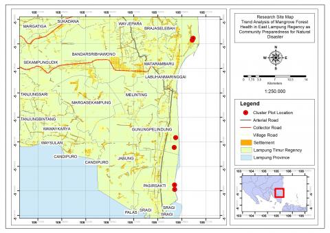
This research is the third-year measurement of the mangrove forest health monitoring activities in the East Lampung Regency (2020, 2021, and 2022) which are located in three locations, including the Margasari mangrove forest, Labuhan Maringgai District; Kuala Penet Resort mangrove forest, TNWK; and the Purworejo mangrove forest, Pasir Sakti District, where each location built two FHM Cluster-plots, as shown in Figure 1. This FHM method is designed to monitor forest health conditions (status, changes, and trends) based on the results of measurements of predetermined ecological indicators (key ecological indicators for the health of Indonesia's tropical rain forests, namely: productivity, vitality, biodiversity, and site quality) [7].
Figure 1. Research location
This research will be carried out in several stages of activities, namely:
1. Measurement of Mangrove Forest Health Trends.
The measurement of the health trend of mangrove forests is carried out in six cluster plots that have been built by measuring ecological indicators, including biodiversity, vitality, and site quality. Calculations were carried out on each parameter of the ecological health indicators of mangrove forests, namely: biodiversity indicators characterized by tree species diversity parameters. Tree species diversity was calculated based on the Shannon-Wiener index value (H'); the vitality indicator was characterized by the parameters of tree damage and canopy conditions. The condition of tree damage was calculated based on the value of the cluster-plot level damage index (CLI) and the canopy condition was calculated based on the value of the visual crown ratio (VCR), and the indicator of site quality was characterized by soil fertility. Soil fertility is calculated based on the value of Cation Exchange Capacity (CEC) from soil analysis [15, 16]. The measurement of trends in the health of mangrove forests in each of the ecological indicators of the health of mangrove forests is as follows:
a. Vitality measurement was carried out by measuring the condition of tree damage and crown condition [15, 16]. Measurement of tree damage and crown condition was carried out on trees in the annular plot.
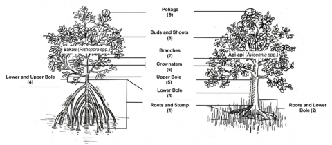
The condition of tree damage was measured based on the location where the damage was found, namely: roots, stems, branches, crowns, leaves, shoots, and shoots (Figure 2).
Figure 2. Location of damage to mangrove trees
If a tree has more than three damages that meet the severity threshold, the first three damage encountered starting from the root are recorded. The tree damage recording consists of three sequential codings that describe the location of the damage to the tree, the type of tree damage, and the severity of the tree caused; performed for a maximum of three damages that meet the severity threshold value, starting with the location with the lowest code.
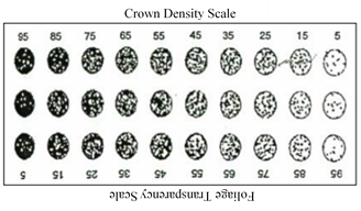
The condition of the tree crown was measured based on the crown parameters, namely: Live Crown Ratio (LCR), Crown Density (Cden), Foliage Transparency (FT), crown diameter, and dieback. The method for measuring all the parameters of the crown condition is to use a scale card, as shown in Figure 3.
Figure 3. Cden-FT scale card
The crown conditions were calculated by the VCR rating. The VCR value for each tree is obtained from the result of each crown condition parameter based on three tree crown condition categories, as shown in Table 1.
Table 1. Categories for tree crown conditions
|
Parameters |
Categories |
||
|
Good (score=3) |
Moderate (score=2) |
Bad (score=1) |
|
|
Live Crown Ratio |
≥40% |
20-35% |
5-15% |
|
Crown Density |
≥55% |
25-50% |
5-20% |
|
Foliage Transparency |
0-45% |
50-70% |
≥75% |
|
Crown Diameter |
≥10.1 m |
2.5-10m |
≤24% |
|
Dieback |
0-5% |
10-25% |
≥30% |
The VCR value of a tree is between 1-4 depending on the magnitude of the observed value for each parameter of the crown condition. Value 1 (very low) if all header condition parameters are 1; 2 (low) if at least 1 parameter is worth 1, but not all parameters; 3 (moderate) if there are more combinations of values 3 and 2 in the header parameter, or all values are 2, but none of the parameters is worth 1; and 4 (high) if all header condition parameters are 3, or only 1 parameter has a value of 2, none of the parameters has a value of 1 [7].
b. Biodiversity measurement is carried out by measuring the diversity of tree species in the research location which is then calculated using the Shannon-Wiener Index formula [17].
c. Measurement of site quality was carried out by taking soil samples from three circular points located between two subplots with each circle having a diameter of 15 cm and a depth of about 30 cm from the ground surface. The level of soil layers from top to the bottom has different soil types and it can give affect sampling in places that have different depths. Soil sampling was taken at a depth of 30 cm because at this depth there was a layer of soil used for root growth [7]. Then soil testing in the laboratory to determine the value of CEC contained in the soil.
2. Processing and data analysis.
Data processing and analysis are carried out on the results of measuring trends in the health of mangrove forests. The data processed and analyzed are CLI, VCR, and CEC data. Processing and analyzing data from the monitoring of changes in the health of this mangrove forest using the Forest Health Assessment Information System (SIPUT) software [15].
3. Assessment and Categorization of Mangrove Forest Health Trends
Assessment of mangrove forest health trends using SIPUT software [15]. Based on this assessment, the categories of health trends for mangrove forests were obtained, namely: good, moderate, and bad [16].
Measurements of forest health in East Lampung Regency were carried out in three locations, namely Margasari mangrove forest, Labuhan Maringgai District; Kuala Penet Resort mangrove forest, TNWK; and the Purworejo mangrove forest, Pasir Sakti District with measurements carried out 3 times. This measurement is carried out using ecological indicators of forest health, including vitality (tree damage and crown condition), biodiversity (diversity of tree species), and site quality (soil Cation Exchange Capacity). In detail, the results of the three measurements are described in Table 2.
Based on Table 2, it is known that the vitality indicator with tree damage parameter (CLI) in all locations has increased. This means that each location experienced an increase in tree damage. The increasing trend of tree damage will have an impact on the decline in tree health which will result in the tree not being able to carry out its functions properly [18]. One of the causes of this condition is the pressure one of the reasons for this situation is the pressure caused by use and management that does not take into account the sustainability aspect. Management that does not take the sustainability aspect into account has an impact on the destruction of the mangrove forest itself. Environmental factors and unsupportive growth locations also affect the state of tree damage, which can stunt a plant's growth. Therefore, this tree damage assessment will be useful in determining sustainable forest management. Tree damage assessment is intended to obtain precise and accurate data and information regarding the condition of tree damage (location, type, and severity of trees) for management decisions of forest managers. For example, in the case of pests and diseases that cause damage. These pests and diseases can reduce the quality and quantity of trees which in turn can lead to failure in harvesting and reduce the income of forest managers. Tree damage can be caused by biotic factors (pests and diseases) and abiotic factors (forest fires, lightning, and management actions). If the damage occurs in a large and lethal area, it will cause harvest failure, while tree protection efforts are generally carried out when the stands have symptoms of advanced damage. Therefore, data and information on the symptoms, causes, severity, and location of forest stand damage are needed to keep the risk of damage below the loss threshold to ensure and realize sustainable forest management.
Table 2. Forest health indicator values
|
Location |
Indicator |
1st Measurement (2020) |
2nd measurement (2021) |
3rd measurement (2022) |
|||
|
CL-1 |
CL-2 |
CL-1 |
CL-2 |
CL-1 |
CL-2 |
||
|
Kuala Penet |
CLI |
0.9 |
0.4 |
0.9 |
0.4 |
0.9 |
0.4 |
|
VCR |
3.7 |
3.9 |
3.7 |
3.9 |
3.9 |
3.9 |
|
|
H' |
0.4 |
0.8 |
0.4 |
0.8 |
0.4 |
0.8 |
|
|
CEC |
19.3 |
19.5 |
19.3 |
19.5 |
19.3 |
19.5 |
|
|
|
|
CL-3 |
CL-4 |
CL-3 |
CL-4 |
CL-3 |
CL-4 |
|
Marga-sari |
CLI |
2.1 |
1.6 |
2.7 |
1.6 |
2.9 |
1.5 |
|
VCR |
3.3 |
3.7 |
2.7 |
3.6 |
2.6 |
2.6 |
|
|
H' |
0.0 |
0.0 |
0.0 |
0.0 |
0.0 |
0.0 |
|
|
CEC |
18.3 |
19.2 |
18.3 |
19.2 |
18.3 |
19.2 |
|
|
|
|
CL-5 |
CL-6 |
CL-5 |
CL-6 |
CL-5 |
CL-6 |
|
Purwo-rejo |
CLI |
1.1 |
1,2 |
1.1 |
1.2 |
1.2 |
1.2 |
|
VCR |
3.6 |
2.9 |
3.6 |
2.9 |
4.0 |
3.5 |
|
|
H' |
0.0 |
0.0 |
0.0 |
0.0 |
0.0 |
0.0 |
|
|
CEC |
16.5 |
17.5 |
16.5 |
17.5 |
16.5 |
17.5 |
|
Description:
CL = Cluster-plot (1, 2, 3, 4, 5, 6)
CLI = Cluster-plot Level Damage Index
VCR = Visual Crown Ratio
H’= Tree species diversity index
CEC = Cation Exchange Capacity
In addition to tree damage, the assessment of the crown condition is also included in the vitality indicator assessment which is important to do. The condition of the tree crown can describe the general health of the tree. The value of the crown condition is known that only the Kuala Penet, TNWK, and Purworejo locations have an increasing trend. Meanwhile, for the location of Margasari, the trend of crown conditions decreased. This is because at the location of Margasari the crown is small and sparse, causing the growth rate to be hampered. Small, sparse crowns indicate unfavorable growing site conditions (such as competition with other trees or too little or too much moisture) or other influences (such as defoliation from insects, disease of the leaves, or windstorms) [19].
The location of the Margasari mangrove forest has shrunk, which suggests that the crown condition at this place is deteriorating, according to the trend value of the crown condition. The availability of nutrients, sunlight, water, and insufficient room for vegetation to develop all contributed to the decline of the vegetation cover in this area [10]. Damage, such as the loss of dominating shoots, leaves, or shoots, as well as damaged shoots, have an impact on the density of the mangrove crown. The amount of sunlight that cannot reach the forest floor is measured by the crown density, which also takes into account the number of plant organs that make up the crown. Crown density can be measured using a scale card of crown density and foliage transparency (Figure 3). The unit of crown density is a percentage (%) and size in multiples of 10%; with crown density criteria, namely: good (≥55%), moderate (25-50%), and bad (5-20%) [7]. Thus, the fraction of total light that is obstructed by trees is known as crown density. The high density of the tree can be interpreted as a tree crown with lush foliage that satisfies the need for photosynthesis to sustain tree growth [10].
Assessment of site quality is a way to determine the level of soil fertility, besides that the assessment of site quality can also be used to determine the chemical processes of the soil that occur through the assessment of cation exchange capacity [20]. Based on the results in Table 2, it is known that for the assessment of the trend of tread quality there is no increase or decrease. This indicates a high CEC value in this mangrove forest because the mangrove ecosystem has soil conditions that are rich in organic matter dissolved in sediment [21]. Mangrove trees will grow well if they are supported by the quality of the site or place of growth that can support optimal growth [22]. Good soil conditions in the mangrove forest will make the plants healthy and resistant to attack by plant pests [23]. Good soil conditions and low damage can improve the health quality of mangrove forests to carry out their functions.
One of the biological components found in the forest is a tree [13]. If biodiversity refers to all living things in a forest, then tree diversity refers to all tree species in a forest [24]. According to the results obtained in Table 2, it is known that the trend of tree diversity did not increase or decrease. This indicates that the tree diversity at each location is constant. The diversity index of tree species is an indicator that reflects the community structure; therefore, ecosystem stability is strongly affected by the high value of the species diversity index [17, 25]. Based on the measurements, it is known that the lowest H' value with H'=0 is observed in Margasari and Purwerejo mangrove forests. The low value of H' is due to the lack of diversity of tree species. The highest H' value is found in mangrove forests on the coast of Kuala Penet, TNWK because many different tree species can be found in this place.
Based on the results of the assessment of each ecological indicator of forest health, the trend values and categories of mangrove forest health in Lampung Timur district are shown in Table 3.
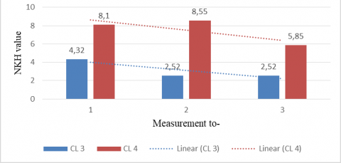
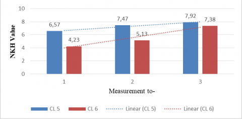
Based on Table 3, the trend value at the location of Kuala Penet, TNWK (8.64-20.90) is in a good category. This is because in because CL-1 and CL-2 are constant. Then the trend value at the Margasari location (2.52-5.57) was in a bad category because CL-3 and CL-4 decreased. This decrease is due to the more significant damage to trees in this location. Furthermore, the trend value in the Purworejo location (5.58-8.63) is in the moderate category, this is because CL-5 and CL-6 increased. The graphs describing the health trend of mangrove forests at each research location are shown in Figures 4, 5, and 6.
Table 3. The trend values and categories of mangrove forest health in Lampung Timur district
|
Location |
1st Measurement (2020) |
2nd measurement (2021) |
3rd measurement (2022) |
Categories |
|
CL-1 (Kuala Penet) |
14.50 |
14.95 |
15.40 |
Good |
|
CL-2 (Kuala Penet) |
20.90 |
20.90 |
20.90 |
Good |
|
CL-3 (Margasari) |
4.32 |
2.52 |
2.52 |
Bad |
|
CL-4 (Margasari) |
8.10 |
8.55 |
5.85 |
Moderate |
|
CL-5 (Purworejo) |
6.57 |
7.47 |
7.92 |
Moderate |
|
CL-6 (Purworejo) |
4.23 |
5.13 |
7.38 |
Moderate |
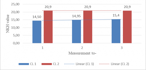
Figure 4. Trend graph of Kuala Penet mangrove forest health value conditions
Figure 5. Trend graph of Margasari mangrove forest health value conditions
According to Figure 4, the trend of mangroves at the CL-1 Kuala Penet location has increased, while the trend at the CL-2 Kuala Penet area has not changed. Based on Figure 4, at the location of the Kuala Penet mangrove forest, namely: the final value of the health condition of the CL-1 mangrove forest has increased (from 14.50 to 15.40). This increase was due to an increase in the value of the visual crown ratio (VCR value from 3.7 to 3.9). The VCR value is the sum of the five crown measurement parameters (LCR, Cden, FT, Crown Diameter, Dieback) which greatly affect the criteria for the condition of the tree crown, while the magnitude of the value will affect the high and low value of the VCR. In CL-1 the VCR value is high because all parameters of the crown condition are worth 3, or only 1 parameter has a value of 2, and none of the parameters has a value of 1. While the final value of the health condition of the CL-2 mangrove forest does not change because the VCR value is constant. Additionally, the value of the mangrove forest's health trend is declining for the Margasari location in CL-1. However, it is fluctuating for CL-2 in Figure 5 below.
According to Figure 5, this suggests that the Margasari mangrove forest's ability to function as a forest has declined. The health of the mangrove forest trended upward in both plot clusters at the site of the Purworejo mangrove forest shown in Figure 6 below.
Figure 6. Trend graph of Purworejo mangrove forest health value conditions
According to the graph in Figures 4, 5, and 6, it is known that there are variations in results between the three research locations based on the findings of the analysis of the value of the mangrove forest health trend. Different mangrove forest management practices in each research location may be to blame for the variation in the health trend of the mangrove forests.
The main function of the forest can run optimally if the constituent trees are in good condition [26]. The trees that make up the vegetation in the mangrove forest will later play a role in the formation of a microclimate, improving air quality and reducing carbon dioxide, as well as protecting the city's water supply [27]. photosynthesis and respiration [28]. Mangrove forests with good tree conditions will certainly have good physiological processes from each plant.
In the context of preparedness in preventing natural disasters, mangrove forests have a function to prevent coastal abrasion, reduce gas emissions, prevent flooding and protect against waves. In addition, the presences of many trees in mangrove forests have provided many benefits such as being able to absorb carbon and filter dirt due to vehicle pollution, reduce air pollutants, and make the surrounding environment shadier [29-31]. Assessment of forest health trends can be one of the efforts in disaster preparedness. If the mangrove forest experiences an increase in the trend value of its forest health, then this indicates that the condition of the forest is in good condition. Thus, the mangrove forest located at the Kuala Penet and Purworejo mangrove forests will affect preventing natural disasters, while the mangrove forest in the Margasari location requires further management in repairing the damaged forest.
In essence, maintaining forest health involves attempting to keep the rate of deforestation below an economically tolerable level [32]. Monitoring the health of the forest is essential to understanding its current condition as well as any future shifts and trends brought on by activities within the forest. Ecological measures of forest health, such as vitality, productivity, biodiversity, and field quality, can be used to assess the health of a forest [7, 16]. In addition to the four key ecological indicators for the health of Indonesia's tropical rainforests, namely: productivity, vitality, site quality, and biodiversity. Other indicators that can be used to measure forest health are regeneration and browse impacts, fragmentation, urbanization, landscapes, carbon, and community socio-economic factors [10, 33]. However, this study measures the available characteristics to determine indices of viability, biodiversity, and land quality.
Data and information on the results of forest health monitoring are important to know for consideration by the government or anyone authorized to manage mangrove forests in making appropriate management decisions [13]. In this case, the decision is used to manage the forest to prevent natural disasters. These decisions include appropriate planning, management, and silvicultural techniques as well as actions that need to be taken on arable land with low ecological indicators. It is hoped that from the existing data and information, forest utilization can be maximized according to its function to achieve a sustainable and sustainable management system [13].
The trend value of the health condition of mangrove forests in East Lampung Regency at each location is Kuala Penet (8.64-20.90) with a good category, Margasari (2.52 -5.57) in the bad category, and Purworejo (5.58-8.63) in the moderate category. Thus, the average trend value of the health condition of mangrove forests in East Lampung Regency is 7.70 (moderate category). Therefore, the right and accurate data and information are needed by the community in management decisions for preparedness for natural disasters in the coastal area of East Lampung Regency.
[1] Safe’i, R., Rezinda, C.F.G., Banuwa, I.S., Harianto, S.P., Yuwono, S.B., Rohman N.A., Indriani Y. (2022). Factors affecting community-managed forest health. Environment and Ecology Research, 10(4): 467-474. https://doi.org/10.13189/eer.2022.1000405
[2] Chen, Q., Li, J., Zhang, L., Lu, H., Ren, H., Jian, S. (2015). Changes in the macrobenthic faunal community during a succession of a mangrove forest at Zhanjiang, South China. Journal Coast Res, 31(2): 315-325. https://doi.org/10.2112/JCOASTRES-D-13-00019.1
[3] Attaee, M.H. (2022). Investigation of the effect of vegetation cover on soil erodibility of river banks. International Journal of Design & Nature and Ecodynamics, 17(3): 333-340. https://doi.org/10.18280/ijdne.170302
[4] Riwayati. (2014). Manfaat dan fungsi hutan mangrove bagi kehidupan. J Kel dan Sejah, 12(24): 17-23. https://doi.org/10.24114/jkss.v12i24.3574
[5] Wahyuni, Y., Kumala, P.E., Simanjuntak, S.M. (2014). Valuasi total ekonomi hutan mangrove di kawasan Delta Mahakam Kabupaten Kutai Kartanegara Kalimantan Timur. J Penelit Kehutanan Wallace, 3(1): 1-12. http://dx.doi.org/10.18330/jwallacea.2014.vol3iss1pp1-12
[6] Maulana, I.R., Safe’i, R., Febryano, I.G., Kaskoyo, H., Rahmat, A. (2022). The relationship between the health of mangrove forests and the level of community welfare. IOP Conf. Ser: Earth Environ Sci., 1027(1): 012033. https://doi.org/10.1088/1755-1315/1027/1/012033
[7] Safe’i, R., Tsani, M.K. (2016). Kesehatan Hutan. Plantaxia. Yogyakarta, 103. https://opac.perpusnas.go.id/DetailOpac.aspx?id=1145598, accessed on Jan. 17, 2022.
[8] USDA-FS. (2020). Forest Ecosystem Health Indicators. Campus Boulevard, 25p.
[9] Hernandez, J.C.M., Martinez, O.F., Romero, B.C., Gama, J.I., Gonzalez, F.M.C. (2022). Susceptibility to flooding of urban areas Puerto Vallarta – Mexico. International Journal of Design & Nature and Ecodynamics, 17(3): 359-367. https://doi.org/10.18280/ijdne.170305
[10] Safe’i, R. (2020). Nilai status dan perubahan kesehatan hutan mangrove (Studi kasus: Hutan mangrove di Desa Margasari, Kecamatan Labuhan Maringgai, Kabupaten Lampung Timur). Perennial, 16(2): 73-79. https://doi.org/10.24259/perennial.v16i2.11268
[11] Djat, W.H. (2017). Miliki 23% ekosistem mangrove dunia, indonesia tuan rumah konferensi internasional mamngrove. p. 9. http://ppid.menlhk.go.id/siaran_pers/browse/561.2018, accessed on Sept. 17, 2022.
[12] Rochmah, S.F., Safe'i. R., Bintoro, A., Kaskoyo, H., Rahmat, A. 2021. The effect of forest health on the social conditions of the community. IOP Conference Series: Earth and Environmental Science, 739(1): 012016. hhttps://doi.org/10.1088/1755-1315/739/1/012016
[13] Widodo, L.M., Safe’i. R., Winarno, G.D., Yuwono, S.B. (2022). Plant success rate in program forest and land rehabilitation in unity batutegi forest management. IOP Conference Series: Earth and Environmental Science, 1030(1): 012005. https://doi.org/10.1088/1755-1315/1030/1/012005
[14] Arwanda, E. R. and Safe’i, R. (2021). Assessment of forest health status of Panca Indah Lestari community plantation forest (case study in Bukit Layang Village, Bakam District, Bangka Regency, Bangka Belitung, Province). IOP Conference Series: Earth and Environmental Science, 918(1): 012031. https://doi.org/10.1088/1755-1315/918/1/012031
[15] Selvira, Safe’i, R., Yuwono S.B. (2022). Assessment of the health of community forest based on rubber (hevea brasiliensis) in Tulang Bawang Regency. IOP Conference Series: Earth and Environmental Science. 1104(1): 012012. https://doi.org/10.1088/1755-1315/1104/1/012012
[16] Pratama, M. R., Safe’i, R., Kaskoyo, H. And Febryano, I. G. (2022). Forestry value for health status: An ecological review. IOP Conference Series: Earth and Environmental Science, 995(1): 012002. https://doi.org/10.1088/1755-1315/995/1/012002
[17] Ajijah, L.N., Safe’i, R., Yuwono, S.B., Kaskoyo, H. (2022). Forest health analysis based on flora biodiversity indicators in Gapoktan Harapan Sentosa KPHL Batutegi, Lampung. IOP Conference Series: Earth and Environmental Science, 995(1): 012003. https://doi.org/10.1088/1755-1315/995/1/012003
[18] Rohman N.A., Safe’i, R. (2022). Health assessment of Tahura Banten as an effort to protect biodiversity. AIP Conference Proceedings, 2563(1): 080004. https://doi.org/10.1063/5.0104731
[19] Safe’i, R., Puspita, E.N., Hilmanto, R. (2022). Assessment of tree vitality as an indicator of monitoring the health condition of community forest in agroforestry patterns. Folia Forestalia Polonica, 64(4): 206-213. https://doi.org/10.2478/ffp-2022-0020
[20] Safe’i, R., Darmawan, A., Irawati, A.R., Pangestu, A.Y., Arwanda, E.R., Syahiib, A.N. (2022). Cluster analysis on forest health conditions in Lampung Province. International Journal of Design & Nature and Ecodynamics, 17(2): 257-262. https://doi.org/10.18280/idjne.170212
[21] Safe’i, R., Maulana, I.R., Ardiansyah, F., Banuwa, I.S., Harianto, S.P., Yuwono, S.B., Apriliyani, Y. (2022). Analysis of damage to trees in the coastal mangrove forest of East Lampung Regency. International Journal of Sustainable Development and Planning, 17(1): 307-312. https://doi.org/10.18280/ijsdp.170131
[22] Heriyanto, N.M., Subiandono, E. (2016). Peran biomasa mangrove dalam menyimpan karbon di kubu raya, Kalimantan Barat. Jurnal Analisis Kebijakan, 13(1): 1-12. https://doi.org/10.20886/jakk.2016.13.1.1-12
[23] Riwayati. (2014). Manfaat Dan Fungsi Hutan Mangrove Bagi Kehidupan. J Kel dan Sejah, 12(24): 17-23. https://doi.org/10.24114/jkss.v12i24.3574
[24] Sari, R.N., Safe’i, R., dan Iswandaru, D. (2019). Biodiversitas fauna sebagai salah satu indikator kesehatan hutan mangrove. Jurnal Perennial, 15(2): 62- 66. https://doi.org/10.24259/perennial.v15i2.6061
[25] Hari, S. (2009). Biodiversitas Mangrove Di Cagar Alam Pulau Sempu. J Sainstek, 1(8): 59-63.
[26] Devianti, Irwansyah, Yunus, Y., Arianti, N.D., Thamren, D.S., Sitorus, A. (2022). Influence of biopores infiltration holes on the level erosion in oil palm plantations area. International Journal of Design & Nature and Ecodynamics, 17(2): 189-184. https://doi.org/10.18280/ijdne.170204
[27] Donato, D.C., Kauffman, J.B., Murdiyarso, D., Kurnianto, S., Stidham, M., Kanninen, M. (2012). Mangrove adalah salah satu hutan terkaya karbon di kawasan tropis. Brief Cifor, 12: 1-10. https://doi.org/10.17528/cifor/003773
[28] Huxham, M., Emerton, L., Kairo, J., Munyi, F., Abdirizak, H., Muriuki, T., Nunan, F., Briers, R.A. (2015). Applying climate compatible development and economic valuation to coastal management: a case study of Kenya's mangrove forests. Journal of environmental management, 157: 168-181. http://dx.doi.org/10.1016/j.jenvman.2015.04.018
[29] Safitri, K.I., Abdoellah, O.S., Gunawan, B., Parikesit, Suparman, Y. (2022). Environmental certification schemes based on political ecology: Case study on urban agricultural farmers in Bandung Metropolitan Area, Indoensia. Journal of Urban Development and Management, 1(1): 67-75. https://doi.org/10.56578/judm010108
[30] Cochard, R., Ranamukhaarachchi, S., Shivakoti, G., Shipin, O., Edwards, P., Seeland, K. (2008). The 2004 tsunami in Aceh and Southern Thailand: A review on coastal ecosystems wave hazards and vulnerability. Perspect Plant Ecol Evol Syst. J Perspect Plant Ecol Evol Syst, 10(1): 3-40. https://doi.org/10.1016/j.ppees.2007.11.001
[31] Kilci, E.N. (2022). Incentives for sustainability: Relationship between renewable energy use and carbon emissions for Germany and Finland. Opportunities and Challenges in Sustainability, 1(1): 29-37. https://doi.org/10.56578/ocs010104
[32] Neni, A., Purnamasari, C. (2017). Peranan Hutan Mangrove Dalam Mengurangi Energi Gelombang Tsunami. Jurnal Pertanian Agros, 19(1): 29-36.
[33] Jia, H.R., Zhang, Y.C. (2022). Optimization of street tree species based on green plot ratio. Journal of Urban Development and Management, 1(1): 26-38. https://doi.org/10.56578/judm010104