Nabeel S. Mahmood | Samar A. Aude | Hasan H. Abdullah | Sadeq O. Sulaiman | Nadhir Al Ansari*
© 2022 IIETA. This article is published by IIETA and is licensed under the CC BY 4.0 license (http://creativecommons.org/licenses/by/4.0/).
OPEN ACCESS
The design of dams requires comprehensive studies to ensure the safety and feasibility of these important engineering projects, as any possible failure case may lead to considerable losses in human life and properties. Specifically, analyses should be performed to evaluate seepage, slope stability, and soil liquefaction of large earth dams. In this study, numerical modeling, based on finite element methods, was used to analyze seepage, slope stability, and liquefaction of Makhoul Dam which is a large zoned dam, currently under construction on Tigris River in the north of Iraq. Earthquake shakings impose additional hysteric and short-term loads that may lead to dam failure due to high pore water pressure, piping, and soil liquefaction. Therefore, the dynamic stability of the dam and soil liquefaction were also evaluated, as a result of applying an earthquake shaking to the dam. For the static condition, the dam was safe against internal erosion and slope failure, as the calculated value of the safety factor was greater than the allowable value. However, the results obtained from the dynamic analysis indicated that a possible earthquake, with an acceleration of 0.38g and 10 seconds period, led to upstream slope failure, a relative displacement as high as 2 meters at the dam crest, and soil liquefaction at the upstream slope. As discussed herein, dam redesign or geotextile reinforcement may be considered to reduce the effects of earthquakes on the dam.
earth dams, dam safety, slope stability, seepage, numerical modeling
The evaluation of slope stability and the analysis of seepage are routine practices of designing earth dams, as any failure case of dams may lead to great human and economic losses. Static slope stability analysis is focused on the calculation of the values of the slope factor of safety. The calculated values are then compared to the correspondent values from the relevant codes to evaluate the stability of the slope [1-4]. The evaluation of slope stability by using the static design method has been widely used to analyze and design unrestrained slopes. This method was first used by Fellenius, Janbu, and Bishop at the beginning of the Twentieth Century which was based on dividing the sliding mass into slices [5, 6]. Furthermore, uncontrolled seepage causes serious problems to the stability of the earth dams. Seepage through the dam body may wash out fine soil partials and lead to piping and may also increase pore water pressure and decrease soil shear strength. The purpose of the seepage analysis is to determine the seepage lines, seepage velocity, the quantity of pore water pressure, and hydraulic gradient [7]. Furthermore, the water level increases the stability of the dam front face during steady-state seepage when the storage is maximum. However, when the drawdown in water level is higher than pore water dissipation from the dam, the increased access pore water pressure may cause slope failure or soil liquefaction [8, 9].
The dynamic stability of slopes is also essential for dams' safety because seismic loads represent a serious threat to dams' stability. Statistics have indicated that earthquakes caused many types of dam failures such as settlement, transfer cracks, internal erosion and piping, and high pore water pressure which may cause soil liquefaction [10-12]. Many factors may affect the possibility of the aforementioned failure types such as the earthquake intensity, type of the dam, topographic conditions of the site, dam and foundation materials, and reservoir water level [13-15]. Therefore, the study of the specific conditions for the dam site as well as the seismic conditions is essential for dynamic stability. The purpose of the dynamic analysis is to determine the dynamic factor of safety as well as the liquefaction zones during earthquakes. The dynamic analysis is also dependent on the static analysis before the occurrence of the earthquake. Furthermore, the slip surface of the dynamic analysis is similar to that of static analysis. However, the values of vertical and horizontal forces, from earthquake acceleration, and the values of excess pore water pressure should be considered in the calculations of the dynamic factor of safety [16, 17]. Moreover, cyclic loadings cause a significant increase in pore water pressure and a sharp decrease in soil shear strength. These changes may cause soil liquefaction phenomena that represent a great danger to the dam stability. The most vulnerable soils are the saturated layers of sand, gravelly sand, and silty sand. Typically, the hydraulic conductivity of gravel is high that it will easily dissipate excess pore water pressure upon shaking unless the gravel layer is confined by fine-grained soils that will prevent water dissipation. Different methods have been previously employed to evaluate the liquefaction potential of a given soil layer. These methods have been developed based on many soil parameters such as grain size distribution, plasticity, and in-situ moisture content [18-20]. These methods have been effectively used in standard practice to evaluate liquefaction potential. However, most of these methods are simi-empirical methods derived from field measurements. Therefore, their reliability is highly dependent of the quality of the field data [18].
With the aid of advanced computers and software, numerical methods have been introduced to analyze the aforementioned slope failure and seepage problems that involve layered soils and complicated boundary conditions. Specifically, iterative procedures based on finite element methods have been extensively used and played the most important role in these types of analyses [1, 2]. Geo-Studio software has been developed based on the finite element methods to analyze slope stability, seepage, and dynamic stability by using the SLOPE/W model, SEEP/W model, and Quake/W model, respectively. This research consists of an analysis of the stability and seepage of a zoned earth dam by using the models of Geo-Studio 2018. Makhoul Dam, which is currently under construction, was selected as a case study as it is considered one of the strategic projects to overcome the deficiencies in water management within the basin of Tigris River. The dam is located in an area with seismic activity as many lights and moderate earthquakes events have recently been recorded within the area. Therefore, the dam stability and any possible case of failure should be evaluated. The research evaluates the current design of the dam in terms of static and dynamic stability and seepage.
For an adequate analysis of the stability and seepage of Makhoul Dam, the analysis should be comprehensive which includes the different conditions of the storage and operation. Models were developed to includes the following conditions: 1) the static stability and seepage at the maximum water level; 2) the stability of the dam during the rapid drawdown condition; 3) the dynamic stability of the dam during earthquake evens; and 4) flow failure due to soil liquefaction.
2.1 Study area and data collected
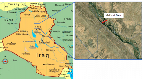
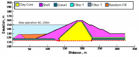
Makhoul Dam was used as a case study which is an earthfall dam with a central clay core that is currently being constructed on Tigris River. The dam is located 15 kilometers to the north of Bayji within Salahuddin Province in Iraq. The dam site is within the coordinates 35.15669 N and 43.43402 E, as shown in Figure 1. The dam is a multi-purpose dam that it will be used for flood control within Tigris River basin, irrigation management, and electricity-generating [21-23]. The details of the dam geometry and the hydraulic properties are presented in Table 1 [24]. The dam is a zoned dam that consists of sand-gravel shells, clay core, and two filter layers, as shown in Figure 2. The engineering properties of the dam materials are listed in Table 2. The material for filter F and T are sand and gravel, respectively.
Figure 1. The location of Makhoul Dam
Figure 2. The cross-section of Makhoul Dam (reproduced from [24])
2.2 Numerical model
Stability and seepage Analysis of different types of dams can be performed by using numerical models which are based on the finite element method. For the Makhoul dam, Geo-Studio software was used to analyze the dam. Specifically, SEEP/W, SLOPE/W, and QUAKE/W were utilized for seepage, static stability, and dynamic stability of the dam, respectively. SEEP/W model was also utilized to study the effect of rapid drawdown in water level on the dam stability. To model the dam with the finite element method, a mesh was represented by quadrilateral and triangular elements and the number of the developed elements was 25736. The total head of 150 m acting on the front face was assigned as a boundary condition of the modal. A steady state condition of water flow was assumed for the seepage analysis.
Table 1. The geometric and hydraulic properties of Makhoul Dam (After [24])
|
Dam Specification |
Quantity |
Dam Specification |
Quantity |
|
Crest level, m |
160 |
Storage at the maximum flood, billion m3 |
2.665 |
|
Difference btw the crest and lowest bed level, m |
56 |
Storage at max. operation level, billion m3 |
2.222 |
|
Crest width, m |
12 |
Storage at lowest operation level, billion m3 |
0.744 |
|
Dam length, m |
3670 |
Reservoir surface area at max. operation level, km2 |
195.6 |
|
Maximum flood water level, m3 |
152.15 |
Discharge of bottom outlet, m3/s |
22200 |
|
Maximum operation level, m3 |
150 |
Discharge of spillway, m3/s |
1338 |
|
Lowest operation level, m3 |
140 |
Generation capacity of the power plant, Megawatts |
260 |
Table 2. The properties of Makhoul Dam soils (After [24])
|
Material zone |
Modulus of Elasticity MN/m2 |
Permeability m/sec |
Poisson's Ratio |
Unit Weight kN/m3 |
Cohesion kN/m2 |
Angle of Internal Friction degree |
|
Shell |
19 |
1.69x10⁻³ |
0.2 |
21 |
0 |
38 |
|
Clay Core |
30 |
3.5x10⁻¹⁰ |
0.33 |
17.8 |
36 |
17 |
|
Filter F |
19 |
1.2x10⁻⁵ |
0.3 |
16 |
0 |
35 |
|
Filter T |
19 |
1x10⁻⁴ |
0.3 |
18.6 |
0 |
35 |
|
Gravel |
20 |
1.2x10⁻⁴ |
0.35 |
20 |
0 |
35 |
|
Random Fill |
19 |
5.5x10⁻⁸ |
0.25 |
17 |
0 |
35 |
3.1 Static analysis
The static analysis, before the earthquake shaking, was performed to determine seepage and slope stability during the dam operation as well as seepage and stability due to rapid drawdown. The steps of static analysis are presented and discussed below.
3.1.1 Slope stability analysis
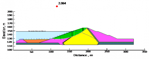
The static factor of safety against slope failure of the front face was determined by using the SLOPE/W model. The slope stability analysis utilized the values of pore water pressure that were obtained from the SEEP/W analysis. The distribution of stress inside the dam is as shown in Figure 3. The total values of total stress were from 700 kPa at the base of the dam to 150 kPa near the dam crest. The calculated value of the factor of safety for the front face was 2.064, as shown in Figure 4. To evaluate the stability of the slope, this value was compared with the allowable values suggested by the design guidelines of USACE 2003 [25]. Accordingly, the dam is safe against slope failure, as the calculated value was greater than the allowable value of the safety factor.
Figure 3. Stress values inside the dam at the maximum storage
Figure 4. Slope stability analysis and factor of safety of the front face of the dam, as obtained from the static analysis
3.1.2 Seepage analysis
SEEP/W was used to analyze seepage at the maximum water level of the reservoir with a study state condition. The phreatic line, flow lines, and pore water pressure distribution in the dam are as shown in Figure 5. The quantity of seepage, as calculated at the specified section, was 2.129x10⁻⁹ cubic meters per second per meter length of the dam. The phreatic line was observed to intersect the filter layers and did not reach the back face of the dam. These observations indicate that the dam is safe against piping. The calculated values of the pore water pressure have been used to analyze the stability of the dam by using SLOPE/W.
Figure 5. Seepage analysis, as obtained from the SEEP/W model
3.1.3 Rapid drawdown
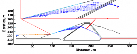
During the events of rapid drawdown, the water level is suddenly decreased in a short time. As a result, the direction of water flow will be reversed towards the dam front face. This phenomenon will significantly decrease the factor of safety against slope failure. Rapid drawdown of the Makhoul Dam reservoir may occur during the events of earthquakes or to accommodate a large flood wave upstream the dam.
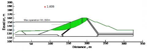
For the current case study, seepage was analyzed by using SEEP/W as the water level was dropped by 22 m (from elevation 150 to 128m) within 10 days period. The variation of the seepage line, as a result of the rapid drawdown, is shown in Figure 6. The value of the factor of safety, as obtained from the rapid drawdown analysis, was 1.606, as shown in Figure 7. According to the design guidelines of USACE 2003 [25], the dam is safe against slope failure, as the calculated value was greater than the allowable value.
3.2 Dynamic analysis
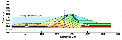
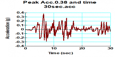
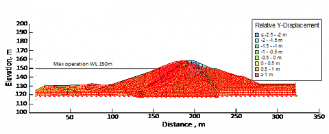
QUAKE/W model was used to analyze the dynamic stability of the dam. The state of stress determined from the static analysis was considered as an initial state in order to evaluate the stresses during the earthquake. Vertical and horizontal components of motion were applied to the dam with peak ground acceleration of 0.38g at 30 seconds period (T), as presented in Figure 8. The parameters of ground motion were determined from the data of seismic activity that are available in the study area. The value of the relative vertical displacement, caused by the earthquake shaking, was as high as 2 m at the top of the dam, as shown in Figure 9. The SLOPE/W model was then applied to evaluate the dynamic factor of safety of the slope. The minimum value of the dynamic safety factor was 1.122 at T of 10 seconds, as shown in Figure 10. The calculated value of the safety factor was less than the allowable value that was given by the USACE 2003 design guidelines [20].
Figure 6. The variation of the seepage line as a result of the rapid drawdown
Figure 7. The factor of safety for the front face as a result of rapid drawdown
Figure 8. Peak ground acceleration of the study area
Figure 9. The relative displacement values after the earthquake shaking
Figure 10. The slope factor of safety, as obtained from the dynamic analysis
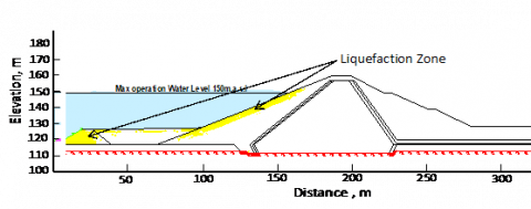
3.3 Soil liquefaction
As the ground motion was applied to the dam, liquefaction was observed within the front face of the dam, as shown in Figure 11. Specifically, earthquake-triggered liquefaction was observed in the upstream slope near the surface as well as in the upstream blanket. The fill soil materials within these zones are fully saturated and when they lost their shear strength during the shaking, started to densify and flow. The observed liquefaction is unacceptable and indicates that the dam is at risk of flow failure. Therefore, the dam may be redesigned to sustain the earthquake triggering. The redesign may include using different fill materials or using geotextile reinforcement to support the liquefiable soil on the front face of the dam.
Figure 11. Liquefiable zones within the front face of the dam
A numerical analysis was performed to evaluate the possible failure cases of the Makhoul zoned earth-fill dam by using GeoSlope software. The seepage, pore water pressure, and factor of safety values were determined from the static analysis. The dynamic stability of the dam was also evaluated as an earthquake shaking was applied to the dam. The following conclusions are drawn from the analysis:
The observations from the seepage analysis indicated that the dam is safe against internal erosion and piping.
The value of the safety factor for the front face, as obtained at the static condition, was 2.064 which indicated that the dam was safe against slope failure, as this value was greater than the allowable value.
Applying an earthquake shaking to the dam produced a relative displacement as high as 2 m at the top of the dam and a value of the safety factor of 1.122 at T of 10 seconds. Based on these observed values, the dam is dynamically unstable.
The liquefaction analysis indicated that the soils of the front shell were vulnerable to liquefaction.
The aforementioned observations are of great importance from the engineering design point of view. Therefore, dam redesign or using geotextile reinforcement within the front shell soils may be considered to increase the values of the factor of safety against slope failure or to increases soil resistance to liquefaction.
The authors would like to acknowledge the financial support generously provided by the Lulea University of Technology (LTU), Sweden. Providing the data of Makhoul Dam by the Ministry of Water Resources of Iraq (MOWR) is acknowledged.
[1] Cheng, Y.M., Lau, C.K. (2001). A study on factor of safety evaluation in slope stability analysis. HKIE Transactions, 8(1): 28-34. https://doi.org/10.1080/1023697X.2001.10667838
[2] Zheng, H., Tham, L.G., Liu, D. (2006). On two definitions of the factor of safety commonly used in the finite element slope stability analysis. Computers and Geotechnics, 33(3): 188-195. https://doi.org/10.1016/j.compgeo.2006.03.007
[3] Salih, A.G. (2019). Influence of clay contents on drained shear strength parameters of residual soil for slope stability evaluation. International Journal of Geomate, 17(59): 166-172. https://doi.org/10.21660/2019.59.38987
[4] Sulaiman, S.O., Abdullah, H.H., Al-Ansari, N., Laue, J., Yaseen, Z.M. (2021). Simulation model for optimal operation of Dokan dam reservoir northern of Iraq. International Journal of Design & Nature and Ecodynamics, 16(3): 301-306. https://doi.org/10.18280/ijdne.160308
[5] Low, B.K., Gilbert, R.B., Wright, S.G. (1998). Slope reliability analysis using generalized method of slices. Journal of Geotechnical and Geoenvironmental Engineering, 124(4): 350-362. https://doi.org/10.1061/(ASCE)1090-0241(1998)124:4(350)
[6] Bishop, A.W. (1955). The use of the slip circle in the stability analysis of slopes. Géotechnique, 5(1): 7-17. https://doi.org/10.1680/geot.1955.5.1.7
[7] Abdulhameed, I.M., Sulaiman, S.O., Najm, A.B.A. (2021). Reuse wastewater by using water evaluation and planning (WEAP) (Ramadi City–Case Study). IOP Conference Series: Earth and Environmental Science, 779(1): 012104. https://doi.org/10.1088/1755-1315/779/1/012104
[8] Uromeihy, A., Barzegari, G. (2007). Evaluation and treatment of seepage problems at Chapar-Abad Dam, Iran. Engineering Geology, 91(2-4): 219-228. https://doi.org/10.1016/j.enggeo.2007.01.012
[9] Cedergren, H.R. (1997). Seepage, Drainage, and Flow Nets (Third edit). John Wiley & Sons.
[10] Hack, R., Alkema, D., Kruse, G.A.M., Leenders, N., Luzi, L. (2007). Influence of earthquakes on the stability of slopes. Engineering Geology, 91(1): 4-15. https://doi.org/10.1016/j.enggeo.2006.12.016
[11] Ausilio, E., Conte, E., Dente, G. (2000). Seismic stability analysis of reinforced slopes. Soil Dynamics and Earthquake Engineering, 19(3): 159-172. https://doi.org/10.1016/S0267-7261(00)00005-1
[12] Newmark, N.M. (1965). Effects of earthquakes on dams and embankments. Géotechnique, 15(2): 139-160. https://doi.org/10.1680/geot.1965.15.2.139
[13] Seed, H.B. (1979). Considerations in the earthquake-resistant design of earth and rockfill dams. Géotechnique, 29(3): 215-263. https://doi.org/10.1680/geot.1979.29.3.215
[14] Gazetas, G. (1987). Seismic response of earth dams: Some recent developments. Soil Dynamics and Earthquake Engineering, 6(1): 2-47. https://doi.org/10.1016/0267-7261(87)90008-X
[15] Sulaiman, S.O., Najm, A.B.A., Kamel, A.H., Al-Ansari, N. (2021). Evaluate the optimal future demand of water consumption in Al-Anbar province in the west of Iraq. International Journal of Sustainable Development and Planning, 16(3): 457-462. https://doi.org/10.18280/ijsdp.160306
[16] Ozkan, M.Y. (1998). A review of considerations on seismic safety of embankments and earth and rock-fill dams. Soil Dynamics and Earthquake Engineering, 17(7-8): 439-458.
[17] Sulaiman, S.O., Al-Ansari, N., Shahadha, A., Ismaeel, R., Mohammad, S. (2021). Evaluation of sediment transport empirical equations: case study of the Euphrates River West Iraq. Arabian Journal of Geosciences, 14(10): 1-11. https://doi.org/10.1007/s12517-021-07177-1
[18] Idriss, I.M., Boulanger, R.W. (2004). Semi-empirical procedures for evaluating liquefaction potential during earthquakes by invited paper the joint the 3rd international conference on earthquake. Geotechnical Engineering (ICEGE) Semi-empirical Procedures for Evaluating Liquefaction Potentia. 11th International Conference on Soil Dynamics and Earthquake Engineering, pp. 32-56.
[19] Zhao, Y., Mahmood, N., Coffman, R.A. (2020). Soil fabric and anisotropy as observed using bender elements during consolidation. International Journal of Geomechanics, 20(4): 1-13. https://doi.org/10.1061/(ASCE)GM.1943-5622.0001630
[20] Abdulkareem, A.H., Eyada, S.O., Mahmood, N.S. (2021). Improvement of a subgrade soil by using EarthZyme and cement kiln dust waste. Archives of Civil Engineering, 67(2). http://dx.doi.org/10.24425/ace.2021.137183
[21] Al-Shahry, G.S., Saleh, S.A. (2017). Flood routing of Tigris river in baiji station and Makhoul Dam reservoir under supposed operation of the dam. Tikrit Journal of Pure Science, 22(1): 115-127.
[22] Sulaiman, S. O., Kamel A.H., Mahmood, N.S., Al-Ansari, N. (2021). The evaluation of the SWAT model performance to predict the runoff values in the Iraqi western desert. Environment and Ecology Research, 9(6): 330-339. https://doi.org/10.13189/eer.2021.090602
[23] Noon, A.M., Ahmed, H.G.I., Sulaiman, S.O. (2021). Assessment of water demand in Al-Anbar Province- Iraq. Environment and Ecology Research, 9(2): 64-75. https://doi.org/10.13189/eer.2021.090203
[24] MWR. (2017). Design Report of Makhoul Dam. Mainstay of Water Resources, Baghdad, Iraq.
[25] USACE (U.S. Army Corps of Engineers). (2003). Engineering and Design, SLOPE STABILITY, Washington, DC.