Muhamad Muslih | Nunik Destria Arianti | Somantri | Dewi Sartika Thamren | Fajri | Ramayanty Bulan*
© 2022 IIETA. This article is published by IIETA and is licensed under the CC BY 4.0 license (http://creativecommons.org/licenses/by/4.0/).
OPEN ACCESS
Land used for residence and agriculture is a source of life, especially in Indonesia. This is because most of the sources of livelihood, especially those living at the sub-district level, are mostly engaged in agricultural activities. Therefore, land data collection is very important, starting at the sub-district level. Unfortunately, the information system that supports this does not yet exist, especially in the Sukabumi district. Hence, this study to overview and use a web-based Geographic Information System (GIS) for land mapping, especially in Sukabumi District, Indonesia. The method used in this study was to conduct interviews with land officials at the sub-district level and several communities in the area. Information system problems from potential users are then addressed by designing a web-based information system and integrating it with GIS applications. The developed information system provides menus and sub-menus adapted to the needs of potential users. So far, the information system has been accessible and can help land officials at the sub-district level and several communities in the area. This will provide the level of detailed information that local communities need in responding to information related to their lands to minimize social conflicts.
appropriate technology, GIS, Indonesia, natural resources, rural communities
In recent years, with the accelerated urbanization of rural areas, mapping as a land resource is becoming increasingly important in order to promote the sustainable use of the land environment. Appropriate mapping is not only carried out directly on the ground but can also involve the involvement of currently available information systems such as geographic information systems (GIS). Globally, geographic information systems have become increasingly popular in the management and decision-making processes associated with regional emergencies and urgent issues. The construction of modern urban pipeline network digital management systems, which primarily include sewage network, water supply network, land use balance, sediment prediction on a watershed, and so on, has already been carried out in many countries around the world, including the United States, Europe and also Indonesia, which have already applied mature geographic information technology [1-4].
Since its inception in the 1990s, land change research has emerged as a significant component in the study of global environmental change and sustainability. Changes in land use, land cover, and land cover in urban areas, particularly the conversion of farmland and forest land to urban uses, are among the most significant kinds of global environmental change [5, 6]. Monitoring land-use changes in urban areas can aid in the decision-making process for urban planning and resource management [7-9]. Remote sensing and geospatial information technology have advanced that they now provide a potential foundation for monitoring land changes in metropolitan settings.
However, only a few studies used the Web to map land by GIS for administrative purposes at the sub-district level. Then, this study aimed to overview and utilise a web-based geographic information system (GIS) for land mapping, especially in Sukabumi District, Indonesia. The outcome of this research is that it is expected that land officials at the sub-district level can quickly check documents from the land.
1.1 Related work
1.1.1 Geographic Information System (GIS)
According to Liu and Yang [10], post-classification change detection provides insight into the nature of land change, and the integration of remote sensing and GIS can be particularly effective for defining spatial patterns of urban land change, according to the researchers.
Mazahreh et al. [11] described a GIS-based technique for determining the feasibility of land for various land-use choices in Jordan's semi-arid conditions. This study utilized various data and maps included inside a GIS to ascertain the appropriateness of various land use types (LUTs). Suitability maps were generated for each land use to illustrate the suitability classes and visualize the geographical representation of agriculturally acceptable soils. Suitability investigations produced information about the sort of land use for which the land was suited and the type of constraints that hampered land usage. Optimal land use options scenarios were developed to increase and maximize agricultural productivity in the research region.
Carver et al. [12] established a GIS model for mapping Scotland's wildness's geographical patterns and distribution. They intend to research a reliable and repeatable approach for mapping wildness in protected landscapes to inform planning, policy, and management choices. They assert that the model is also scalable, capable of being implemented at various geographical scales ranging from local to national, depending on data needs and available computational resources. The work reported here demonstrates that combining local knowledge with the careful application of local-level statistics inside bespoke GIS models may be a strong instrument for assisting in developing specific planning policies and actions for wild land conservation and management.
1.1.2 Web-based GIS
Web-based GIS has long been used for many purposes. A significant advantage of online mapping apps is that they provide efficient distribution of geographical data without extra software [13]. Also, experts can control environmental or contextual (streets, rivers) layers centrally instead of distributing along with software to each end-user [14]. A facilitated soil information system for the United Arab Emirates and its usefulness in agricultural land use planning are among the applications for which Abdelfattah and Kumar [15] employ it. Each component of the system is comprised of multiple parts, including a geographic soil database, a field operating system, and a very intuitive web-based secure application. The UAESIS is described in detail in this document, including its structure, capabilities, functions, advantages, applications, and uses. Two case studies are offered to show the system's applicability to the appraisal of land appropriate for date palm cultivation and the growing of salt-tolerant crops, respectively.
Other research by Rao et al. [16] indicated that the USDA's Conservation Reserve Program is managed and planned to utilize a web-based GIS Decision Support System (CRP). They assert that the integrated web-GIS DSS is built utilizing a web server and Java Servlet technology on top of an ArcIMS platform to enable remote data access and processing. The prototype DSS was used to model the sediment and nutrient dynamics of a small watershed in the Panhandle of Oklahoma.
In Indonesia, Web-based GIS has been widely used for various purposes. As used by Amalia et al. [17] for tropical diseases-prone areas in East Java Province. To encourage halal tourism in Bukittinggi, Afnarius et al. [18] presented information about places of worship. Ginardi et al. [19] for asset management of land and building of Madiun city government. However, to date, no research utilizes Web-based GIS for mapping for administrative purposes at the sub-district level. The main challenge of developing this system is that each region has its characteristics regarding land management.
1.1.3 Evidence of ownership of land rights
Evidence of ownership of land rights or letter C document is official proof of land ownership in Indonesia. Letter C document is evidence of ownership of land rights in Indonesia [20]. The land is the primary requirement for people, as human existence is inextricably linked to the soil. The Indonesian state is undergoing changes in the way land ownership rights are structured, followed by the issuing of land-related legislation. Recognize the early signs of land rights ownership between community members and government agencies in conflict zones [20].
Letter C of land ownership in Indonesia is very important. According to Suryadi et al. [21], three community groups and authorized officials are divided by a letter C letter. Even after the first owner passes away, the inheritance such as right over land, which is according to the inheritance division certificate, must be divided together between some heirs; alternatively, if the inheritance division certificate has not yet been issued, the right transfer is listed to the heirs who deserve the joint rights based on the proof as to the heirs or the inheritance certificate. Therefore, a clear land ownership data collection system at the sub-district level is important to avoid conflict. In addition, the system should also be easily accessible by the community.
1.2 Research positioning
Previous literature has shown various after-effects result from GIS and their functional for mapping. Research trends tend to focus more on the technical part of the problem. However, the application of web-based geographic information systems (GIS) has only been briefly covered in earlier studies. Hence, this research attempts to investigate the application of Web-based GIS for administrative purposes at the sub-district level. It also tries to highlight the menu Web-based GIS has been developed and how to used it. Moreover, the existence of this system will greatly assist land officials at the sub-district level to be able to record the area and designation of the land within the scope of their work so as to minimize conflicts that exist in the community. Disputes over land claims and cultivating land in the community occur if the origin of the land cannot be properly and properly archived. Web-based GIS will assist in clarifying and providing data and archives of the history of the existing land. For this reason, this research attempts to define the function of geographic information systems (GIS) in transformation administration at the sub-district level as well. This paper developed a Web-based GIS in accordance with the needs of land officials at the sub-district level and the use is also the surrounding community of the sub-district.
As a case study in Sukabumi District (Cisande Village, Cicantayan District), the data collected consisted of village locations, village maps, coordinate points, village profiles, satellite photos, land data, and Letter C data. The data was obtained from various sources, such as interviews and observations with several expert officers about the village.
In developing a web-based information system with integration into a GIS, the flow is as shown in Figure 1. In summary, the first thing to do is analyze potential users' needs. From this point it will be known the expectations of the users of the Web-based GIS that will be developed. Next, do the design for the information system to be developed. After that, carry out the construction of the developed information system. After the system is formed, testing is carried out for all developed menus and sub-menus. In addition, within a certain period after being disseminated to users, system maintenance is important to find out if there are bugs in the system.
Figure 1. Flowchart of research stages
The system development method used in this study uses the waterfall of software development life cycle (SDLC). SDLC is a process for developing software with the greatest possible quality at the lowest possible cost in the shortest amount of time. SDLC establishes a well-structured flow of stages that enables an organization to rapidly deliver high-quality software that has been thoroughly tested and is suitable for production usage [22]. These are just a few of the reasons why it is critical to create a secure software development life cycle [23]. It appears critical to expand the notion of security and to recognize that security must be a component of every growth.
User analysis is used to investigate problems that occur in the field [24]. It is necessary to identify possible solutions that can be used to address the analytical design.
The design phase allows a researcher to get effective and interactive search media in a certain location. This step requires the programmer to create a design sketch for easy conversion into a specific format. Interactive search media is related to the demand of users who will be involved in using the developed Web-based GIS to be comfortable enough to use this system. In this paper, the Unified Modeling Language (UML) is used in the system design [25], including use case diagrams, class diagrams, and activity diagrams.
Next, construction is the process of writing program code on a computer. The process of coding this design is transforming it into a language that the computer can understand.
A black-box approach conducted system testing [26]. In particular, tests are carried out on the input and output menus of the system to test its functional performance. Therefore, software developers in black box testing can create multiple input condition scenarios to train all the system's functional requirements.
Finally, maintenance focuses on periodic checking of the system, which involves correcting some error menus that have not been found in the previous stage. This is always important to update the system to work properly every time.
The principle of the program design of the developed web-based GIS is that there are three main users. The first user is a user who can access web-based GIS information from outside without having to log in. These users are people who get general information from Web-based GIS. The second user is a user who must carry out a log-in verification process to view more detailed information on land and add the latest information from certain lands. The third user is the admin, who is in charge of verifying the land proposed by the second user. In addition, the admin will be in charge of maintaining this developed system. Besides that, the website-based land mapping GIS interface design consists of eight main pages. Each main page consists of at least several menus that can be broken down. The system's appearance was developed using Indonesian language because, in general, the users of this system are local people from Indonesia. This follows the statement of Pan et al. [27], which states that the development of an information system must be appropriate and in accordance with the user community.
3.1 Login page
The login menu is prepared to perform data management. Login menu is also widely used in various information system developments in an effort to improve the security of the information system [28]. This form consists of filling in the username and password to log in. Figure 2 shows a screenshot of the login page of the developed system.
Figure 2. System login page screenshot
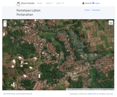
3.2 Home page
The dashboard page will appear after the admin has successfully logged in by correctly filling in the username and password. The use of dashboards to display the functionality of a system in real time has been around for quite some time. Dashboard pages are widely used in the development of information systems, especially web-based, to increase the friendliness of the system to the user [29]. On this page, the admin can monitor the history of previous inputs. The input history is in the form of map libraries. Figure 3 displays a dashboard page of the developed system.
Figure 3. Dashboard page of the system
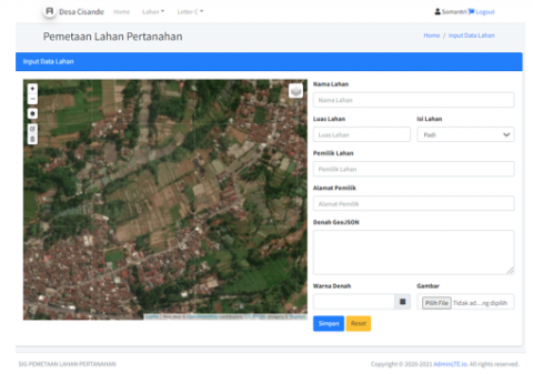
3.3 Land data input page
This page provides a form to input data related to information from the land. The input data provided consists of several fields according to the information on the existing land categories in the field. A screenshot of the land data input page is presented in Figure 4.
Figure 4. Land data input page
3.4 Photo gallery page
This page provides a photo gallery form consisting of various data that has been inputted from the land data input page. This page also provides a click add photo menu to add supporting data in photos related to the land. The click adds photo menu is also integrated with the add photo gallery page, which provides a form to add photo descriptions and image forms. Screenshots of the photo gallery page and add photo gallery are presented in Figure 5.
Figure 5. Photo gallery page and add photo gallery
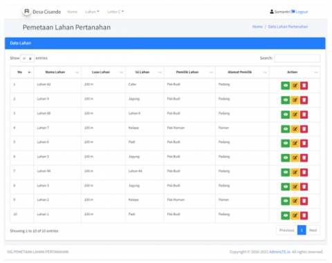
3.5 Land data page
The land data page serves to show the input of land data that has been stored. This page consists of land data information, land area, land contents, landowner, and address landowner. Figure 6 shows a screenshot of the land data page of the developed system.
3.6 Land data editing page
Admin can change information related to land data through the land data edit page. This page provides a menu of changing data related to land according to real conditions in the field. For example, if there is a change in land area due to buying and selling activities, this page can change ownership information related to the land. A screenshot of the land data edit page is presented in Figure 7.
Figure 6. Land data page
Figure 7. Land data edit page
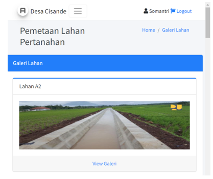
3.7 Land gallery page
This page displays land data that has been inputted and stored in the land gallery. The photos presented in a gallery page are merely thumbnails [30, 31]. Those photographs, which are located in steganogallery, have been linked to their respective full-sized counterparts. The thumbnails are made immediately following the copying and renaming of the full-sized photographs. A screenshot of the land data edit page is shown in Figure 8.
3.8 Letter C of data input page
Land administration, a case study in Cisande Village, Cicantayan District, Sukabumi Regency, Indonesia, has two soil types criteria: dry land (yards, fields, etc.) and wetland (wetland in the form of rice fields). Each of the criteria for the type of land is given a code called a different block number, followed by information related to the date of the change in ownership of the land. Figure 9 shows a screenshot of the developed system's letter C data input page.
Figure 8. Land gallery page
Figure 9. Screenshot of input data letter C
The study utilized various data and maps included inside a GIS and tandem with web-based to ascertain the appropriateness of various land-use types has been conducted. A case study in Cisande Village, Cicantayan District, Sukabumi Regency, Indonesia, has been used as a pilot project. Appropriate mapping is not only carried out directly on the ground but can also involve the involvement of currently available information systems such as geographic information systems (GIS). Besides, land change science has established itself as a critical component of global environmental change and sustainability. The developed web-based GIS consists of eight main menus (login, homepage, land data input, photo gallery, land data page, land data editing, land gallery, and letter C) that can be accessed online and have provided information related to the land being developed. Monitoring land-use changes in urban areas can aid in the decision-making process for urban planning and resource management. Moreover, the existence of this system will greatly assist land officials at the sub-district level to be able to record the area and designation of the land within the scope of their work so as to minimize conflicts that exist in the community. The future work of this research is to study the impact of using this system on the socio-culture of the area to improve the capabilities of this developed system further.
[1] Li, Z., Hu, X., Zhang, X., Gong, L., Jiang, Z., Xing, Y., Ding, J., Tian, J., Huang, J. (2022). Distributed treatment of rural environmental wastewater by artificial ecological geographic information system. Journal of King Saud University-Science, 34(3): 101806. https://doi.org/10.1016/j.jksus.2021.101806
[2] Yu, Q., Maddah-Ali, M.A., Avestimehr, A.S. (2020). Straggler mitigation in distributed matrix multiplication: Fundamental limits and optimal coding. IEEE Transactions on Information Theory, 66(3): 1920-1933. https://doi.org/10.1109/TIT.2019.2963864
[3] Saing, Z., Djainal, H., Deni, S. (2021). Land use balance determination using satellite imagery and geographic information system: Case study in South Sulawesi Province, Indonesia. Geodesy and Geodynamics, 12(2): 133-147. https://doi.org/10.1016/j.geog.2020.11.006
[4] Devianti, Fachruddin, Purwati, E., Thamren, D.S., Sitorus, A. (2021). Application of Geographic Information Systems and Sediment Routing Methods in Sediment Mapping in Krueng Jreu Sub-Watershed, Aceh Province, Indonesia. International Journal of Sustainable Development and Planning, 16(7): 1253-1261. https://doi.org/10.18280/ijsdp.160706
[5] Sartika, T.D., Pandjaitan, N.H., Sitorus, A. (2017). Measurement and modelling the drainage coefficient for hydraulic design criteria on residential area. In 2017 International Conference on Computing, Engineering, and Design (ICCED), pp. 1-5. https://doi.org/10.1109/CED.2017.8308092
[6] Cebro, I.S., Sitorus, A. (2019). Performance evaluation of a hand tractor to climbing sloping land. International Journal of Scientific and Technology Research, 8(7): 781-785.
[7] Deng, J.S., Wang, K., Hong, Y., Qi, J.G. (2009). Spatio-temporal dynamics and evolution of land use change and landscape pattern in response to rapid urbanization. Landscape and Urban Planning, 92(3-4): 187-198. https://doi.org/10.1016/j.landurbplan.2009.05.001
[8] Yu, W., Zang, S., Wu, C., Liu, W., Na, X. (2011). Analyzing and modeling land use land cover change (LUCC) in the Daqing City, China. Applied Geography, 31(2): 600-608. https://doi.org/10.1016/j.apgeog.2010.11.019
[9] Mallupattu, P.K. Sreenivasula Reddy, J.R. (2013). Analysis of land use/land cover changes using remote sensing data and GIS at an Urban Area, Tirupati, India. The Scientific World Journal. https://doi.org/10.1155/2013/268623
[10] Liu, T., Yang, X. (2015). Monitoring land changes in an urban area using satellite imagery, GIS and landscape metrics. Applied Geography, 56: 42-54. https://doi.org/10.1016/j.apgeog.2014.10.002
[11] Mazahreh, S., Bsoul, M., Hamoor, D.A. (2019). GIS approach for assessment of land suitability for different land use alternatives in semi arid environment in Jordan: Case study (Al Gadeer Alabyad-Mafraq). Information Processing in Agriculture, 6(1): 91-108. https://doi.org/10.1016/j.inpa.2018.08.004
[12] Carver, S., Comber, A., McMorran, R., Nutter, S. (2012). A GIS model for mapping spatial patterns and distribution of wild land in Scotland. Landscape and Urban Planning, 104(3): 395-409. https://doi.org/10.1016/j.landurbplan.2011.11.016
[13] Farkas, G. (2017). Applicability of open-source web mapping libraries for building massive Web GIS clients. Journal of Geographical Systems, 19(3): 273-295. https://doi.org/10.1007/s10109-017-0248-z
[14] Flemons, P., Guralnick, R., Krieger, J., Ranipeta, A., Neufeld, D. (2007). A web-based GIS tool for exploring the world's biodiversity: The Global Biodiversity Information Facility Mapping and Analysis Portal Application (GBIF-MAPA). Ecological Informatics, 2(1): 49-60. https://doi.org/10.1016/j.ecoinf.2007.03.004
[15] Abdelfattah, M.A., Kumar, A.T. (2015). A web-based GIS enabled soil information system for the United Arab Emirates and its applicability in agricultural land use planning. Arabian Journal of Geosciences, 8(3): 1813-1827. https://doi.org/10.1007/s12517-014-1289-y
[16] Rao, M., Fan, G., Thomas, J., Cherian, G., Chudiwale, V., Awawdeh, M. (2007). A web-based GIS Decision Support System for managing and planning USDA's Conservation Reserve Program (CRP). Environmental Modelling & Software, 22(9): 1270-1280. https://doi.org/10.1016/j.envsoft.2006.08.003
[17] Amalia, A., Afifa, R.M., Herriyance, H. (2018). Resource description framework generation for tropical disease using web scraping. 2018 IEEE International Conference on Communication, Networks and Satellite (Comnetsat), pp. 44-48. https://doi.org/10.1109/COMNETSAT.2018.8684030
[18] Afnarius, S., Akbar, F., Yuliani, F. (2020). Developing web-based and mobile-based GIS for places of worship information to support halal tourism: A case study in Bukittinggi, Indonesia. ISPRS International Journal of Geo-Information, 9(1): 52. https://doi.org/10.3390/ijgi9010052
[19] Ginardi, R.H., Gunawan, W., Wardana, S.R. (2017). WebGIS for asset management of land and building of Madiun city government. Procedia Computer Science, 124: 437-443. https://doi.org/10.1016/j.procs.2017.12.175
[20] Paryanto, P. (2021). Letter C document as a preliminary evidence of ownership of land rights (Study in Kebumen District, Indonesia). Journal of Law and Legal Reform, 2(3): 329-352. https://doi.org/10.15294/jllr.v2i2.46535
[21] Suryadi, H.D., Daulay, Z., Benni, B. (2019). The making of inheritance certificate in the process of transferring right over land by inheritance in Padang. International Journal of Multicultural and Multireligious Understanding, 6(2): 348-356. https://doi.org/10.18415/ijmmu.v6i2.707
[22] Pinciroli, F., Barros Justo, J.L., Forradellas, R. (2020). Systematic mapping study: On the coverage of aspect-oriented methodologies for the early phases of the software development life cycle. Journal of King Saud University - Computer and Information Sciences. https://doi.org/10.1016/j.jksuci.2020.10.029
[23] de Vicente Mohino, J., Bermejo Higuera, J., Bermejo Higuera, J.R., Sicilia Montalvo, J.A. (2019). The application of a new secure software development life cycle (S-SDLC) with agile methodologies. Electronics, 8(11): 1218. https://doi.org/10.3390/electronics8111218
[24] Liang, A.W., Wahid, N., Gusman, T. (2021). Virtual campus tour application through markerless augmented reality approach. JOIV: International Journal on Informatics Visualization, 5(4): 354-359. https://doi.org/10.30630/joiv.5.4.743
[25] Chien, C.F., Chen, G.Y.H., Liao, C.J. (2019). Designing a connectivist flipped classroom platform using unified modeling language. International Journal of Online Pedagogy and Course Design (IJOPCD), 9(1): 1-18. https://doi.org/10.4018/IJOPCD.2019010101
[26] Pareek, P., Chande, S.V. (2021). Grey box approach for mobile application testing. Rising Threats in Expert Applications and Solutions, ed: Springer, pp. 411-419.
[27] Pan, S.Y., Gao, M., Kim, H., Shah, K.J., Pei, S.L., Chiang, P.C. (2018). Advances and challenges in sustainable tourism toward a green economy. Science of the Total Environment, 635: 452-469. https://doi.org/10.1016/j.scitotenv.2018.04.134
[28] Supriyatna, A., Puspitasari, D. (2021). Implementation of extreme programming method in web based digital report value information system design. IJISTECH (International Journal of Information System & Technology), 5(1): 67-75. https://doi.org/10.30645/ijistech.v5i1.116
[29] Batty, M. (2015). A perspective on city dashboards. Regional Studies, Regional Science, 2(1): 29-32. https://doi.org/10.1080/21681376.2014.987540
[30] Hioki, H. (2008). Steganogallery: Steganographic gallery. 2008 IEEE 10th Workshop on Multimedia Signal Processing, pp. 719-724. https://doi.org/10.1109/MMSP.2008.4665169
[31] Balocco, C., Petrone, G.L. (2021). Sustainability and wellbeing in healthcare facilities. An investigation inside a historic hospital. International Journal of Design & Nature and Ecodynamics, 16(5): 477-485. https://doi.org/10.18280/ijdne.160501