Hua Ding* | Xiaonan Li | Jingwen Dai | Yanqing Xue
© 2020 IIETA. This article is published by IIETA and is licensed under the CC BY 4.0 license (http://creativecommons.org/licenses/by/4.0/).
OPEN ACCESS
China is an active responder to the UNESCO Geopark Program, and owns a total of 39 UNESCO Global Geoparks (UGGp). This paper firstly reviews the history of UGGp in China, and systematically analyzes their spatial distribution with Gini coefficient, Lorentz curve and kernel density estimation (KDE). Next, the influencing factors of the spatial distribution were examined through spatial regression. The main results are as follows: The density of UGGp in China decreases from the east to the west and from the south to the north. The spatial distribution of UGGp in China is extremely non-uniform: most are concentrated in East, Central and Southwest China, while a few are located in Northeast and Northwest China. Spatial regression results indicate that the regional/provincial distribution of UGGp is significantly affected by government support, tourism and infrastructure, slightly affected by landform, and weakly affected by the distribution of geosites. In future, China should prioritize the construction and application of UGGp in geosites with international significance in Northwest and Northeast China, and the government at all levels must provide more supports to developing geosites with regional features.
UNESCO global geoparks (UGGp), history, spatial distribution, influencing factors
In April 1999, The United Nations Educational, Scientific and Cultural Organization (UNESCO) put forward the UNESCO Geopark Program on its 155th Executive Board session, in a bid to establish 500 geoparks around the world at an annual rate of 20 [1]. In 2004, the UNESCO organized the Global Geoparks Network (GGN), which aims to protect environment, publicize earth science and promote economic sustainability [2]. As of December 2019, the GGN covered a total of 147 geoparks from 41 countries and regions.China has always been an active responder and implementer of the UNESCO Geopark Program. At present, 39 (17.81%) geoparks in China are GGN members, taking up 26.53% of all UNESCO Global Geoparks (UGGp).
In recent years, foreign scholars have mainly studied the following aspects of UGGp: development and protection of geosites [3-6], construction and management of geoparks [7-9], general features of UGGp [10-14], geological tourism [15-18], and unique features of a single UGGp [19-23].
Meanwhile, Chinese scholars started to explore geoparks in 2001. The relevant studies mostly focus on the National Geoparks of China. When it comes to UGGp, the domestic research emphasizes on the features, background and international comparison of UGGp, rather than their spatial distribution.
Considering the above, this paper systematically summarizes the history of UGGp in China, and analyzes their spatial distribution with Gini coefficient, Lorentz curve and kernel density estimation (KDE). The influencing factors of the spatial distribution were examined through spatial regression. The research findings provide technical and theoretical supports to the site selection, construction and development of UGGp in China.
As shown in Table 1, the history of UGGp in China can be divided into three phases: preparatory phase, initial phase and development phase.
(1) Preparatory phase (pre-1999)
The protection of geosites in this phase lays a good basis for establishing UGGp. China began to protect geosites in the 1970s. But only a few items were protected, compared with other types of nature reserves. In 1984, the State Council approved the first national geological reserve: the Middle and Upper Proterozoic Stratigraphic Section of Jixian County, Tianjin. In 1987, the former Ministry of Geology and Mineral Resources issued the Regulations on Establishing Geological Nature Reserves. In 1995, the former Ministry of Geology and Mineral Resources issued the Regulations on the Protection and Management of Geosites. As of 1998, China has established 4 national geological reserves and 31 provincial geological reserves.
(2) Initial phase (1999-2005)
In 1999, China officially became one of the pilot countries of the UNESCO Geopark Program. According to the provisions of the UNESCO, only national geoparks are eligible to apply for designation as a UGGp. Therefore, China launched a program to establish national geoparks in 2000. In 2003, The UNESCO released the Guidelines and Criteria for National Geoparks seeking UNESCO's assistance to join the Global Geoparks Network (GGN). Under the Guidelines, China actively promoted the UGGp application. In 2004, the first batch of 8 national geoparks became UGGp. In 2005, another 4 were recognized as UGGp. However, no policy or technical specification on geoparks was issued in this phase.
(3) Development phase (post-2005)
In this phase, China released a series of guidelines, requirements, notices, technical specifications and standards for geoparks, which standardized the development of UGGp. In May 2018, the State Council underwent a major institutional reform. Through the reform, the competent authority of UGGp in China was changed from the Ministry of Land and Resources to the Administration Office of Geosites and Geoparks, Department of Natural Reserves, National Forestry and Grassland Administration. Since then, China has become more professional in the construction of UGGp. In this phase, 2 national geoparks were designated as UGGp each year, except for 1 in 2012 and none in 2007 and 2016.
Table 1. History of UGGp in China
|
Phases |
Main events |
|
Preparatory phase (pre-1999) |
In 1984, the State Council approved the first national geological reserve: the Middle and Upper Proterozoic Stratigraphic Section of Jixian County, Tianjin; In 1985, the term “geological park” was used for the first time in China on the first Geological and Natural Heritage Protection Zoning Work Conference; In 1987, the former Ministry of Geology and Mineral Resources issued the Regulations on Establishing Geological Nature Reserves, marking the first step to build a legal system of geoparks; In 1989, International Union of Geological Sciences (IUGS) set up the Working Group on the Geological Heritage to register geological heritage; In 1995, the former Ministry of Geology and Mineral Resources issued the Regulations on the Protection and Management of Geosites, and started to register geosites. |
|
Initial phase (1999-2005) |
In 1999, The UNESCO put forward the UNESCO Geopark Program; Being a pilot country of the Program, China prepared the Geological Heritage Protection Plan for the Next Decade, and kicked off the construction of national geoparks; In 2000, the National Geosites Protection (Geopark) Leading Group and the National Geopark Expert Review Committee were established; In 2001, the former Ministry of Land and Resources approved the first batch of national geoparks (MLR [2001] No. 76); In 2002, The UNESCO released the Guidelines and Criteria for National Geoparks seeking UNESCO's assistance to join the Global Geoparks Network (GGN), which received positive response from China; In April 2003, China initiated the UGGp application; In April 2004, the former Ministry of Land and Resources issued the Notice on Strengthening the Construction of UNESCO Global Geoparks in China (MLR [2004] No. 80); In June, 2004, the 1st International Conference on UNESCO Global Geoparks was held in Beijing, and the Office of Global Geoparks Network was established. |
|
Development phase (Post-2005) |
In October 2006, the former Ministry of Land and Resources issued the Guidelines for the Construction of National Geoparks of China; In November 2008, the former Ministry of Land and Resources issued the Technical Requirements for Editing and Revision of National Geoparks Planning (MLR[2008] No. 126); In May 2009, the former Ministry of Land and Resources issued the Notice on Strengthening the Application, Examination and Approval of National Geoparks (MLR [2009] No. 50); In June 2010, the former Ministry of Land and Resources issued the Notice on the Construction and Acceptance of National Geoparks (MLR [2010] No. 40); In April 2013, the former Ministry of Land and Resources issued the National Geopark Construction Standard (MLR [2013] No. 345); In 2014, the former Ministry of Land and Resources issued the Standard for Geoheritage Investigation in China (2014); In July 2016, the former Ministry of Land and Resources issued the Technical Requirements for Editing and Revision of National Geoparks Planning (2016 Revision); In May 2017, the former Ministry of Land and Resources issued the Regulations for Geoheritage Investigation (DZ/T0303-2017); In March 2018, the Central Committee of the Communist Party of China (CPCCC) issued the Plan for Deepening the Reform of the Party and State Institutions, which integrates the geopark management into the newly established National Forestry and Grassland Administration (NFGA); In November 2018, the NFGA held the first UNESCO Global Geopark Annual Meeting. |
Table 2. List of UGGp in China
|
Year and Batch |
Name |
Number |
|
2004 (1st batch) |
Huangshan UGGp, Lushan UGGp, Yuntaishan UGGp, Shilin UGGp, Danxiashan UGGp, Zhangjiajie UGGp, Wudalianchi UGGp, Songshan UGGp |
8 |
|
2005(2nd batch) |
Yandangshan UGGp, Taining UGGp, Hexigten UGGp, Xingwen UGGp |
4 |
|
2006 (3rd batch) |
Taishan UGGp, Wangwushan-Daimeishan UGGp, Leiqiong UGGp, Fangshan UGGp, Jingpohu UGGp, Funiushan UGGp |
6 |
|
2008 (4th batch) |
Longhushan UGGp, Zigong UGGp |
2 |
|
2009 (5th batch) |
QinlingZhongnanshan UGGp, Alxa Desert UGGp |
2 |
|
2010 (6th batch) |
LeyeFengshan UGGp, Ningde UGGp |
2 |
|
2011 (7th batch) |
Tianzhushan UGG, Hong Kong UGGp |
2 |
|
2012 (8th batch) |
Sanqingshan UGGp |
1 |
|
2013 (9th batch) |
Yanqing UGGp, Shennongjia UGGp |
2 |
|
2014 (10th batch) |
Mount Kunlun UGGp, Dali-Cangshan UGGp |
2 |
|
2015 (11th batch) |
Dunhuang UGGp, Zhijindong Cave UGGp |
2 |
|
2017 (12th batch) |
Arxan UGGp, Keketuohai UGGp |
2 |
|
2018 (13th batch) |
Guangwushan-NuoshuiheUGGp, HuanggangDabieshan UGGp |
2 |
|
2019 (14th batch) |
Jiuhuashan UGGp, Yimengshan UGGp |
2 |
3.1 Overall distribution
(1) Regional and provincial distributions
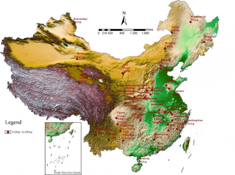
China can be divided into seven geographical regions [24]: North China, Northeast China, East China, Central China, South China, Southwest China, and Northwest China. Each region has a number of UGGp: 11 in East China, 7 in Central China, 6 in Southwest China, 5 in North China, 4 in South China, 4 in Northwest China and 2 in Northeast China (Table 3, Figure 1).
(2) Altitude distribution
The altitude of China gradually decreases from the west to the east, in the form of three steps. As shown in Figure 2, the UGGp in China are mostly located on the second step, the third step and the transition zone between the second and third steps (e.g.Fangshan UGGp, Yuntaishan UGGp, and Wangwushan-Daimeishan UGGp).
Figure 1. Regional and provincial distributions of UGGp in China
Figure 2. Altitude distribution of UGGp in China
Table 3. Regional and provincial distributions of UGGp in China
|
Geographical regions |
Provincial distribution |
Name of UGGp |
|
North China (5) |
Beijing (1) |
Yanqing UGGp |
|
Beijing, Hebei (1) |
Fangshan UGGp |
|
|
Inner Mongolia (3) |
Alxa Desert UGGp, Arxan UGGp, Hexigten UGGp |
|
|
Northeast China (2) |
Heilongjiang (2) |
Wudalianch iUGGp, Jingpohu UGGp |
|
East China (11) |
Shandong (2) |
Taishan UGGp, Yimengshan UGGp |
|
Zhejiang (1) |
Yandangshan UGGp |
|
|
Anhui (3) |
Tianzhushan UGG, Huangshan UGGp, JiuhuashanUGGp |
|
|
Fujian (2) |
Ningde UGGp, Taining UGGp |
|
|
Jiangxi (3) |
Longhushan UGGp, Lushan UGGp, Sanqingshan UGGp |
|
|
Central China (7) |
Henan (4) |
Songshan UGGp, Wangwushan-Daimeishan UGGp, Funiushan UGGp, Yuntaishan UGGp |
|
Hubei (2) |
HuanggangDabieshan UGGp, Shennongjia UGGp |
|
|
Hunan (1) |
Zhangjiajie UGGp |
|
|
South China (4) |
Guangxi (1) |
LeyeFengshan UGGp |
|
Guangdong (1) |
Danxiashan UGGp |
|
|
Guangdong, Hainan (1) |
Leiqiong UGGp |
|
|
Hong Kong (1) |
Hong Kong UGGp |
|
|
Southwest China (6) |
Sichuan (3) |
Zigong UGGp, Xingwen UGGp, Guangwushan-Nuoshuihe UGGp |
|
Yunan(2) |
Shilin UGGp, Dali-Cangshan UGGp |
|
|
Guizhou (1) |
Zhijindong Cave UGGp |
|
|
Northwest China (4) |
Shaanxi (1) |
QinlingZhongnanshan UGGp |
|
Xinjiang (1) |
Keketuohai UGGp |
|
|
Gansu (1) |
Dunhuang UGGp |
|
|
Qinghai (1) |
Mount Kunlun UGGp |
3.2 Spatial structure
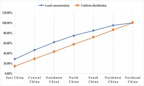
Based on the regional and provincial distributions, the spatial structure of UGGp in China was analyzed by Gini coefficient and Lorenz curve. The Gini coefficient describes the concentration degree of the distribution of spatial elements. The changes in geological distribution can be ascertained by comparing the Gini coefficients of multiple spatial elements. Meanwhile, the Lorenz curve provides an intuitive display of the concentration and uniformity of spatial elements. The Gini coefficient Gini can be calculated by:
$G_{i n i}=\frac{-\sum_{i=1}^{N} p_{i} \ln p_{i}}{\ln N} C=1-G_{\mathrm{ini}}$
where, C is the distribution uniformity; pi is the percentage of the number of UGGp in a province/region out of the total number of UGGp in China; N is the number of regions. The $\boldsymbol{G}_{\text {ini}} \in[0,1]$ has a positive correlation with concentration, and a negative correlation with C.
The calculation results Gini=0.9435 and C =0.0565 show that the distribution of UGGp in features local concentration and low uniformity. According to the Lorenz curves of UGGpdistribution in China (Figure 3), more than 60% of UGGp in China exist in East, Central and Southwest China.
Figure 3. Lorenz curves of UGGpdistribution in China
3.3 Hotspots of spatial distribution
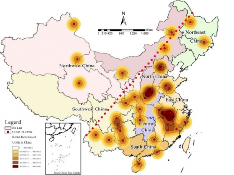
First, the authors established a database of geospatial attributes, based on the latitudes and longitudes obtained from Google Earth. Then, the KDE algorithm was selected from the Spatial Analyst Toolbox of ArcGIS 10.2, and used to measure the spatial distribution density of UGGp in China [25]. On this basis, the kernel density map of the seven geographical regions was generated (Figure 4), in which the number (density) of UGGp in an area is positively correlated with the darkness of the local color.
Figure 4. Kernel densities of UGGp in China
It can be seen that the density of UGGp in China decreases from the east to the west and from the south to the north. Most UGGp in China are concentrated in East and Southwest China; a number of UGGp are located in North China; only a few are situated in West China. The results further confirm the two features of spatial distribution: local concentration and low uniformity. In the light of the kernel density map, the spatial distribution of UGGp in China contains 2 high-density areas, 1 medium density area and 4 low-density areas.
(1) High-density areas
The two high-density areas are the border between Hubei, Anhui and Jiangxi (East China), and the Henan Section of Taihang Mountains (Central China).Located in theDabie Mountains-Southern Anhui Mountain System, the former high-density area is a mountainous area dominated by intrusive rocks, involving UGGp like Huangshan, Tianzhushan, Jiuhuashan and Dabieshan. In the south of North China Craton, the latter high-density area is featured by geosites of tectonic landforms and stratigraphic sections, involving UGGp like Funiushan, Yuntaishan and Wangwushan-Daimeishan.
(2) Medium density area
Known for its karst landform, the medium density area covers the middle part of Yunnan-Guizhou Plateau and the border between Sichuan and Guizhou (Southwest China). The UGGp in this area include Zigong, Xingwen, Zhijindong, and Leye-Fengshan.
(3) Low-density areas
The four low-density areas are Jing-Ji cluster area (North China), Taishan-Yimenshan cluster area (East China), central Qinling cluster area (Northwest China), and Zhangjiajie-Shennongjia cluster area (Central China).
4.1 Background
There are several defects with the spatial distribution of UGGp in China:
(1) The spatial distribution is out of balance, and basically follows the Hu Line (the straight line between Aihui County, Heilongjiang and Tengchong, Yunnan). Proposed by Chinese geologist Hu Huanyong in 1935, the Hu Line marks a striking difference in the distribution of China's population.According to the Fifth National Census (2000), the region to the east of the Hu Line is home to 94.1% of the total population of China, despite taking up only 43.8% of the country’s land mass.
Out of the UGGp in China, 39 are located to the east of the Hu Line, and only 4 to the west (Figure 4). The non-uniform layout is inconsistent with the distribution of geosites in China.As of 2015, a total of 5,619 important geosites (including 2,433 basic geosites, 3,269 geomorphic landscape sites, and 108 geological disaster sites) and 247 world-class geosites had been discovered across China [26]. Most of them are concentrated in geologically active areas and regions with abrupt changes in landform. In particular, the Qinghai-Tibet Plateau, Taihang Mountains, Hengduan Mountains and Tianshan Mountains boast a variety of valuable geosites. However, UGGp is extremely rare in these resource rich areas.
(2) The UGGpdistribution does not reflect the features of each region. In general, the geosites in Northeast China are mainly volcanic landforms; the southern parts of North China and Northeast China have important geological sections and fossil sites; Southwest China has a wealth of karst landforms and fossils, with glaciers, alpine canyons and inland high-altitude salt lakes on the Qinghai-Tibet Plateau; Northwest China enjoys unique wind-erosion and ice-erosion landforms, and loess is highly developed on the Loess Plateau in Shaanxi, Gansu and Shanxi; East China, including the eastern coastal areas, boast unique landform of the Yangtze River Delta and sea-erosion landform. However, there is no UGGp that fully demonstrates the regional features of the Loess Plateau, Qinghai-Tibet Plateau, Taihang Mountains (Shanxi section), and the eastern coastal areas.
(3) The geosites with value of reference have not become GGN members. Many stratigraphic sections in China are of great value in scientific research, such as the Precambrian continental facies profile in Jixian County, Tianjin, the profile between Paleozoic and Mesozoic strata in Changxing, Zhejiang, as well as the Jinshitan profile in Dalian, Liaoning. In addition, the trove of fossils in Chengjiang, Yunnan records the unparalleled emergence of organisms in the early Cambrain. Unfortunately, none of these geositeshave been developed into UGGp. It is urgently needed to protect and utilize these sites through UGGp construction.
Considering the values of geositesin science, tourism and reference, this paper attempts to verify whether the spatial distribution of UGGp in China is influenced by economy, infrastructure, tourism and government support, and evaluate the degree of influence of each factor.
4.2 Analysis on influencing factors
4.2.1 Model construction
Multiple regression was employed to ascertain the factors that influence the provincial/regional proportion of UGGp in China and their contributions. In traditional regression model, the correlation effect between objects is largely ignored. To ensure the fitting results, the spatial effect was included into the traditional econometric model. There are two commonly used spatial econometric models, namely, spatial lag model (SLM) and spatial error model (SEM).
The SLM is also known as spatial autoregressive model. This model can be expressed as:
$y=\rho W_{y}+X \beta+\varepsilon$ (1)
where, y is the dependent variable; X is the independent variable; ρ is the spatial regression coefficient; β is the parameter vector; W is the spatial weight matrix; ε is the white noise. The spatial regression coefficient measures the degree of spatial interaction between observations, while the spatial weight matrix is constructed by the adjacency principle.
The SEM mainly measures how much the observations are affected by the impact of random errors from other objects. This model can be expressed as:
$y=X \beta+\varepsilon ; \varepsilon=\lambda \beta+\mu$ (2)
where, ε is regression residual vector; W is the spatial weight matrix; λ is the autoregressive coefficient. The spatial weight matrix is still constructed by the adjacency principle; the autoregressive coefficient measures the spatial dependence of observations.
4.2.2 Variable selection
Let y be the provincial/regional proportion of UGGp in China. Then, the y value can be computed by:
$y=N_{i} / N_{t}$ (3)
where, Ni is the number of UGGp in the i-th province/region; Nt is the total number of UGGp in China.
Next, the set of factors affecting the spatial distribution of UGGp in China can be defined as X={Ri, Hi, Ei, Fi, Ti, Gi}, where R is the number of geosites (the number of world-class geosites), H is the terrain (altitude), E is economy (per capita GDP), F is infrastructure (mileage of expressways, national highways and provincial highways), T is tourism (the total number of tourists per year) and G is government support (the local government’s expenditure on geosite protection).
4.2.3 Data sources
The data on the variables of each province/region were collected from the following sources: the number of world-class geosites was extracted from the Geosite Survey Report released by China Geological Survey; the altitude data were downloaded from the database of geospatial attributes based on Google Earth; the economic data were acquired from China Statistical Yearbook 2018, China Statistical Yearbook on Science and Technology 2018, The Yearbook of China Tourism Statistics 2018, the CEInet Statistics Database, and the official websites of provincial bureau of statistics. The data on each province/region were derived from the mean value of each provincial administrative region (here inafter referred to as “province”).
4.2.4 Results analysis
Table 4. Regression results on the influencing factors of provincial/regional spatial distribution
|
Variables |
SLM |
SEM |
|
Number of geosites(R) |
0.3824*(0.0615) |
0.3564*(0.0593) |
|
Landform (H) |
-0.7547***(0.0092) |
-0.7869***(0.0087) |
|
Economy(E) |
0.837***(0.0010) |
0.876***(0.0098) |
|
Infrastructure (F) |
0.926***(0.0030) |
0.932***(0.0023) |
|
Tourism (T) |
0.931***(0.0019) |
0.943***(0.0014) |
|
Government support (G) |
0.941***(0.0040) |
0.947***(0.0031) |
Note: ***, ** and * are the significance levels of 1%, 5% and 10%, respectively; the bracketed values are p-values.
Formulas (2) and (3) were regressed separately. The results of the SEM and the SLM are compared in Table 4. It can be seen that the SEM clearly outshined the SLM in regression coefficient and significance. This means the former model is more convincing.
As shown in Table 4, the regional/provincial distribution of UGGp in China is based on the spatial layout of geosites, but the correlation between the two factors is not yet strong. Government support, tourism and infrastructure make the greatest contributions to the formation of the current regional/provincial distribution of UGGp in China.
The spatial correlation coefficient of government support is 0.947 and significant on the 1% level. Therefore, government support, including policy support, system supply and fiscal input, plays a decisive role in the UGGp construction and application in China, and serves as the main reason for the spatial imbalance of UGGp in different geographical regions.
Moreover, the spatial correlation coefficient of tourism is 0.943 and significant on the 1% level. This means regional tourism can greatly promote the UGGp construction and application. As a result, the local government should regard UGGp as an important part of regional tourism products and brand building, while protecting geosites and the environment.
Table 5. Tourism development of UGGp in China
|
Geological region |
Province |
Name of UGGp |
Class |
Number of tourists (104) |
Tourism income (100 million yuan) |
|
North China |
Beijing |
Yanqing UGGp |
5A |
109.12 |
0.2 |
|
Fangshan UGGp |
4A |
572.5 |
9.7 |
||
|
Inner Mongolia |
Alxa Desert UGGp |
4A |
727.8 |
67.4 |
|
|
Arxan UGGp |
5A |
431.9 |
52.7 |
||
|
Hexigten UGGp |
4A |
600.1 |
63.2 |
||
|
Northeast China |
Heilongjiang |
Wudalianchi UGGp |
5A |
172.8 |
5.7 |
|
Jingpohu UGGp |
5A |
93.1 |
2.2 |
||
|
East China |
Shandong |
Taishan UGGp |
5A |
562.1 |
11.1 |
|
Yimengshan UGGp |
5A |
394.8 |
21.3 |
||
|
Zhejiang |
Yandangshan UGGp |
5A |
892.3 |
89.5 |
|
|
Anhui |
Tianzhushan UGG |
5A |
120.1 |
1.2 |
|
|
Huangshan UGGp |
5A |
338.1 |
16.2 |
||
|
Jiuhuashan UGGp |
5A |
1082.5 |
130.7 |
||
|
Fujian |
Ningde UGGp |
5A |
534.2 |
32.2 |
|
|
Taining UGGp |
5A |
553.2 |
45.3 |
||
|
Jiangxi |
Longhushan UGGp |
5A |
2301.7 |
8.3 |
|
|
Lushan UGGp |
5A |
5934.5 |
380.2 |
||
|
Sanqingshan UGGp |
5A |
2327.2 |
209.4 |
||
|
Central China |
Henan |
Songshan UGGp |
5A |
399.3 |
3.25 |
|
Wangwushan-Daimeishan UGGp |
5A |
182.4 |
2.6 |
||
|
Funiushan UGGp |
5A |
1181.0 |
61.4 |
||
|
Yuntaishan UGGp |
5A |
639.4 |
6.1 |
||
|
Hubei |
HuanggangDabieshan UGGp |
4A |
260.1 |
12.1 |
|
|
Shennongjia UGGp |
5A |
1590.3 |
57.3 |
||
|
Hunan |
Zhangjiajie UGGp |
5A |
3028.9 |
262.5 |
|
|
South China |
Guangxi |
LeyeFengshan UGGp |
4A |
530.9 |
54.4 |
|
Guangdong |
Danxiashan UGGp |
5A |
260.9 |
5.78 |
|
|
Guangdong, Hainan |
Leiqiong UGGp |
4A |
177.8 |
1.6 |
|
|
Hong Kong |
Hong Kong UGGp |
—— |
—— |
—— |
|
|
Southwest China |
Sichuan |
Zigong UGGp |
4A |
165.4 |
27.1 |
|
XingwenUGGp |
4A |
714.5 |
92.3 |
||
|
Guangwushan-Nuoshuihe UGGp |
4A |
201.5 |
15.8 |
||
|
Yunan |
Shilin UGGp |
5A |
280.3 |
4.3 |
|
|
Dali-Cangshan UGGp |
4A |
608.6 |
28.3 |
||
|
Guizhou |
Zhijindong Cave UGGp |
4A |
166.6 |
16.6 |
|
|
Northwest China |
Shaanxi |
QinlingZhongnanshan UGGp |
4A |
490.4 |
56.1 |
|
Xinjiang |
Keketuohai UGGp |
5A |
36.8 |
0.4 |
|
|
Gansu |
Dunhuang UGGp |
5A |
1077.3 |
115.2 |
|
|
Qinghai |
Mount Kunlun UGGp |
4A |
347.3 |
19.0 |
Note: Number of tourists and tourism income are from statistics in 2018.
As shown in Table 5, the 39 UGGp in China, including 25 5A-class and 13 4A-class scenic spots, have an average number of tourists of 7.9178 million and an average tourism income of 5.233 billion yuan per year. Hence, the existing UGGp in China have been successful in tourism. Of course, some scholars have pointed out the problem of overexploitation of geological sites.
Furthermore, the spatial correlation coefficients of infrastructure and economy are respectively 0.932 and 0.876, both of which are significant on the 1% level. The results show that the number of regional/provincial UGGp is positively correlated with the quality of infrastructure and the level of economy in that region/province.
According to the regression results of landform and number of geosites, the number of regional/provincial UGGp has a negative correlation with the altitude of that region/province; the number of world-class geosites in different geographical regions has little impact on the spatial distribution of UGGp in China.
This paper probes deep into the spatial distribution of UGGp in China and its influencing factors. Based on the history of UGGp in China, the spatial distribution was investigated by Gini coefficient, Lorentz curve and KDE. After that, the SEM was introduced to measure the contribution of several factors to the current spatial distribution. The results show that the spatial distribution of UGGp in China has two defining features: local concentration and low uniformity; most UGGp are located in East, Central and Southwest China, and only a few exist in Northeast and Northwest China; government support, tourism and infrastructure are the leading influencing factors of the spatial distribution of UGGp in China, followed in descending order by landform and the distribution of geosites. On this basis, the authors put forward three suggestions for future development of UGGp in China.
(1) On the national level, prioritize the construction and application of UGGp with international significance in Northwest and Northeast China.
The 247 world-class geosites in China are concentrated in geologically active areas and regions with abrupt changes in landform. However, most of the existing UGGp lie to the east and south of the Hu Line. To the west and north of that line, the Qinghai-Tibet Plateau, Taihang Mountains, Hengduan Mountains and Tianshan Mountains boast a variety of valuable geosites. But UGGp is extremely rare in these resource rich areas. To overcome the mismatch between UGGp and geosites, China should give priority to the construction and application of UGGp in the following areas: the Loess Plateau in Shaanxi, Gansu and Shanxi, the unique wind-erosion and ice-erosion landforms in Xinjiang and Gansu, and the glaciers, alpine canyons and inland high-altitude salt lakes on the Qinghai-Tibet Plateau.
(2) On the regional level, highlight local features of geosites through regional collaboration.
Across the seven geographical regions in China, most geoparks have rock-soil landform or volcanic landform. To highlight the local features of geosites, different provinces should work together to support the construction of UGGp on the following geosites: basic geosites (structural section and rock section)with high value of reference; water bodies and coastlines with high landscape value and landforms with Chinese characteristics; geological disaster geosites with high scientific value. The ultimate goal is to create a complete system of UGGp that covers all kinds of geosites, providing a great showcase of the geological features across the country and different regions.
(3) On the local level, step up the support to UGGp construction in West and North China.
In West and North China, the local governments at all levels should attach greater importance and step up the support to the construction of UGGp. For example, the local governments should optimize support policies and system supply, increase the fiscal input in UGGp research, construction and application, and concentrate the efforts on several key geoparks. In this way, the regional difference in UGGp of China will be minimized, and the balanced distribution of UGGp will fully protect regional geosites, bring more social benefits and promote regional economy.
This work is supported by Social Science Fund for Research Project on Major Theoretical and Practical Problems in Shaanxi Province, China, 2019 (Grant No. 2019Z198) and Special Fund of Basic Research and Operating Expenses for Central Universities, Chang’an University (Special Research on Tourist Resorts).
[1] Jones, C. (2008). History of Geoparks. Geological Society, London, Special Publications, 300(1): 273-277. https://doi.org/10.1144/SP300.21
[2] Zouros, N. (2004). The European geoparks network - geological heritage protection and local development. Episodes, 27(3): 165-171. https://doi.org/10.18814/epiiugs/2004/v27i3/002
[3] Han, J.F., Wu, F.D., Tian, M.Z., Li, W. (2018). From geopark to sustainable development: Heritage conservation and geotourism promotion in the Huangshan UNESCO Global Geopark (China). Geoheritage, 10: 79-91. https://xs.scihub.ltd/https://doi.org/10.1007/s12371-017-0227-2
[4] Kim, H.S., Lim, C. (2019). Developing a geologic 3D panoramic virtual geological field trip for Mudeung UNESCO global geopark, South Korea. Episodes, 42(3): 235-244. https://doi.org/10.18814/epiiugs/2019/019019
[5] Fauzi, N.S.M., Misni, A. (2016). Geoheritage conservation: Indicators affecting the condition and sustainability of geopark– a conceptual review. Procedia - Social and Behavioral Sciences, 222(23): 676-684. https://doi.org/10.1016/j.sbspro.2016.05.224
[6] Gabriel, R., Moreira, H., Alencoão, A., Faria, A., Silva, E., Sá, A. (2018). An emerging paradigm for the UNESCO global geoparks: The ecosystem’s health provision. Geosciences, 8(3): 100. https://doi.org/10.3390/geosciences8030100
[7] Lima, E.A., Machado, M., Guerreiro, M., Nunes, J.C., Costa, M.P. (2018). Geological heritage management in small islands: The example of the Azores UNESCO Global Geopark (Portugal). Geoheritage, 10: 659-671. https://doi.org/10.1007/s12371-018-0328-6
[8] Guimarães, E.S., Sá, A., Gabriel, R., Moreira, H., Guimarães, J.R.S., Bandeira, P.F.R., Silva, J.M.F.L., Soares, R.C., Melo, J.P.P. (2018). Matrix of priorities for the management of visitation impacts on the geosites of Araripe UNESCO Global Geopark (NE Brazil). Geosciences, 8(6): 199. https://doi.org/10.3390/geosciences8060199
[9] Henriques, M.H., Brilha, J. (2017). UNESCO Global Geoparks: A strategy towards global understanding and sustainability. Episodes, 40(4): 349-355. https://doi.org/10.18814/epiiugs/2017/v40i4/017036
[10] Cimermanova, I. (2010). Geoparks in Slovakia. Acta Geoturistica, 1(2): 34-40.
[11] Ding, H., Chen, X., Zhang, Y.Y. (2012). Research on space distribution, tourism benefit and future development of global Geoparks in China. Economic Geography (China), 32(12): 187-190. https://doi.org/10.15957/j.cnki.jjdl.2012.12.033
[12] Chen, N.Z. (2016). The cultivation of geopark construction and sustainable competiveness. Research on Heritages and Preservation, 1(2): 67-72. https://doi.org/10.19490/j.cnki.issn2096-0913.2016.02.015
[13] Wu, L.J., Zhu, H.Y., Chen, W.H., Rong, Y.B., Mo D.G., Rong, H.L. (2019). Patterns and prospects on the UNESCO global geoparks in China. Geological Review, 65(5): 1198-1216. https://doi.org/10.16509/j.georeview.2019.05.010
[14] Singtuen, V., Gałka, E., Phajuy, B., Won-In, K. (2019). Evaluation and geopark perspective of the Geoheritage Resources in Chiang Mai Area, Northern Thailand. Geoheritage, 11(4): 1955-1972. https://doi.org/10.1007/s12371-019-00410-0
[15] Justice, S.C. (2018). UNESCO global geoparks, geotourism and communication of the earth sciences: A case study in the Chablais UNESCO Global Geopark, France. Geosciences, 8(5): 149. https://doi.org/10.3390/geosciences8050149
[16] Guo, W., Chung S.S. (2019). Using tourism carrying capacity to strengthen UNESCO global geopark management in Hong Kong. Geoheritage, 11: 193-205. https://doi.org/10.1007/s12371-017-0262-z
[17] Shui, W., Xu, G. (2016). Analysis of the influential factors for changes to land use in China’s Xingwen Global Geopark against a tourism development background. Geocarto International, 31(1): 22-41. https://doi.org/10.1080/10106049.2015.1041558
[18] Gonzalez-Tejada, C., Du, Y., Read, M., Girault, Y. (2017). From nature conservation to geotourism development: Examining ambivalent attitudes towards UNESCO directives with the global geopark network. International Journal of Geoheritage, 5(2): 1-20. https://doi.org/10.17149/ijg.j.issn.2210.3382.2017.02.001
[19] Martínez-Frías, J., Mederos, E.M., Lunar, R. (2017). The scientific and educational significance of geoparks as planetary analogues: The example of Lanzarote and Chinijo Islands UNESCO Global Geopark. Episodes, 40(4): 343-347. https://doi.org/10.18814/epiiugs/2017/v40i4/017035
[20] Putu, S.A.S. (2018). KontribusiBatur Global Geopark dalam perekonomian lokal di Kintamani. Jurnal Master Pariwisata, 4(2): 253-268. https://doi.org/10.24843/JUMPA.2018.v04.i02.p07
[21] Ramsay, T. (2017). Forest FawrGeopark-a UNESCO Global Geopark distinguished by its geological, industrial and cultural heritage. Proceedings of the Geologists’ Association, 128(3): 500-509. https://doi.org/10.1016/j.pgeola.2017.12.010
[22] Guo, F. S., Chen L. Q., Xu, H., Liu, X. (2018). Origin of beaded Tafoni in cliffs of Danxia landscapes, Longhushan Global Geopark, South China. Journal of Mountain Science, 15(11): 2398-2408. https://doi.org/10.1007/s11629-018-4947-9
[23] Arcana, K.T.P., Wiweka K. (2016). Educational tourism’s product strategy at Batur global geopark, Kintamani, Bali. International Research Journal of Management, IT and Social Sciences, 3(7): 43-52. https://sloap.org/journals/index.php/irjmis/article/view/384
[24] Zhou W.Y. (2011). Geographical divisions of China. Education of Geography, 2011(Z1): 39.
[25] Hou, Q.H., Zhang, X., Li, B., Zhang, X.Q., Wang, W.H. (2018). Identification of low-carbon travel block based on GIS hotspot analysis using spatial distribution learning algorithm. Neural Computing & Applications, 31(9): 4703-4713. https://doi.org/10.1007/s00521-018-3447-8
[26] Tian, T.S., He, X. (2016). Establish nature reserves for geological relics so as to provide human-beings with physical files of the earth's evolution. World Environment, 5: 66-69.