OPEN ACCESS
Landslide is one of the three geological disasters worldwide, mainly distributing in mountainous and hilly areas. Due to natural factors and frequent human activities, a variety of landslide is endless at reservoir area. Through analyzing reservoir landslide and taking Outang landslide for example, using Seep/W finite element flow analysis module and Slope/W stability analysis module of Geo-Studio two-dimensional numerical simulation software, setting natural conditions and a variety of reservoir water level, rainfall conditions to simulate the landslide seepage, and importing slope stability analysis module through seepage field model, the this paper flow curve and stability are obtained in this paper.
Landslide, Seep/W finite element flow analysis module, Slope/W stability analysis, Water level
The research of landslide stability is an important topic. Due to the lack of early recognition at home and abroad, regarding soil as the study object was the starting point of early study of landslide stability, whose characteristic is the research method of combination of mechanics of materials, elasticity, elastoplastic theory and empirical method. But such methods were still used to rock landslide, which was obviously unreasonable, so the obtained results are far different from the actual results.
The generation of landslide slope first need sliding space and the generation of cutting surface on both sides. From the point of the landslide materials, the shear strengths of loose soil, weathered zone and gravel soil are low, which are easy to slide. The groundwater and surface water, saturating the soils of landslide body, increasing the weight of the landslide body and reducing the shear strength of rock and soil, at last causing landslides, whose impacts are also great.
From the start of quantitative viewpoint, based on the geological environment and the actual situation of Reservoir wading landslide, take the typical wading landslide-- Outang landslide for example, the landslide stability is evaluated through calculate the field of seepage flow and landslide stability by the two modules of SEEP/W, SLOPE/W in Geo-studio—two-dimensional numerical simulation analysis software.
Landslide stability is influenced by two factors, one of which is the rising and falling of reservoir water level, scouring the leading edge of rock, rock and soil soaked by water, and slowly tending to saturation condition, resulting in the reduction of the shear strength parameters of rock and soil. Another one is that the rainfall supplies the water for landslide. Water enters into landslide from the cracks, lowering the shear strength parameters of the rock-soil body of landslide. From the purpose of the study, considering the following various conditions, and on the basis of which to analyze and calculate.
This numerical simulation selected natural state landslide. Three working conditions are as follows:
ConditionⅠ: The reservoir water level of the leading edge 155m rising to 175m;
ConditionⅡ: The reservoir water level of the leading edge 175m falling to 145m;
Condition Ⅲ: daily rainfall 144mm (Storm), the reservoir water level of the leading edge 175m falling to 145m;
Calculation principle: in the analysis of landslide stability, when the water table is buried shallowly, the soil water moves both in the saturated region or the unsaturated zone, there is a certain link between which, so when this situation happens, we can combine these two issues to discuss, namely become saturated-unsaturated flow problems. The saturated and non-saturated part of the soil in landslide mostly depend on them in the upper or lower part of the water line. When in the upper part, the soil is non-saturated, and vice versa. When the water level changes, the water level of the landslide will also change. This change forms a saturated zone and the unsaturated zone. At this situation, assuming h is the dependent variable, and the equation of the anisotropy of the two-dimensional saturated - unsaturated flow is:
$\frac{\partial }{\partial \text{X}}\left( {{k}_{x}}\frac{\partial {{h}_{w}}}{\partial X} \right)+\frac{\partial }{\partial \text{Y}}\left( {{k}_{Y}}\frac{\partial {{h}_{w}}}{\partial Y} \right)+Q={{m}_{W}}{{\gamma }_{W}}\frac{\partial {{h}_{w}}}{\partial t}$ (1)
where: $\mathrm{k}_{\mathrm{X}}$- x direction of permeability coefficient
$\mathrm{k}_{\mathrm{y}}$- y direction of permeability coefficient
Q- the boundary flow applied
$\gamma_{\mathrm{w}}$- the gravity of water
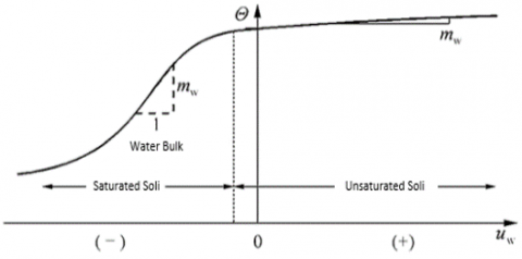
$\mathrm{m}_{\mathrm{w}}$- volume-weight, is the slope of the resides curve of volumetric water.
$m_{\mathrm{w}=}-\frac{\partial \theta_{w}}{\partial\left(u_{a}-u_{w}\right)}$
head boundary: $\left.\mathrm{k} \frac{\partial h}{\partial n}\right|_{r 1}=h(x, y, t)$;
flow boundary: $\left.\mathrm{k} \frac{\partial h}{\partial n}\right|_{r 2}=q(x, y, t)$.
When the water flows though the soil, some of it will remain in the soil structure, and the remained water volume is the function of pore water pressure and soil structure characteristics. Volumetric water content is defined as the ratio of the volume of water retention in the soil and the total volume, with the formula as follows:
$\theta =\,\frac{{{V}_{W}}}{V}$ (2)
where: VW- the volume of water in soil unit
V- the total volume of the soil
Figure 1. The relation curve of the content of volume water and pore water pressure
When the soil of landslide is saturated, that is 100% water saturation, we approximately think that the volumetric water content of the soil and its porosity factor are equal. The Volumetric water content of soil is influenced by two factors: First, the change of the stress state in soil; the second is the nature of soil. Generally, when analyzes seepage, we assume that there are two constant values: (1) total stress of the soil body, (2) pore air pressure. So the problem we need to solve becomes a single related issue, that is to say, the volumetric water content is only correlated with pore water pressure, so it would be relatively easy to solve. In this case, the relation curve of volumetric water content $\theta$ and pore water pressure UW is shown in Figure 1, and its formula is as follows:
$\partial \theta =\,{{m}_{W}}\partial {{u}_{W}}$ (3)
where: UW - pore water pressure
Permeability coefficient (hydraulic conductivity) is used to express the degree of difficulty of that water flows through the soil pore skeleton, hydraulic conductivity is affected by volumetric water content(moisture content), and the relation of the moisture content and pore water pressure is a function. Moisture content is the dependent variable of the function of pore water pressure. The relation of the moisture content and permeability coefficient is also a function, and the permeability coefficient is also the dependent variable of the function of moisture content. After deducing, the indirectly relation of permeability coefficient and pore water pressure is an indirect function. (Figure 2)
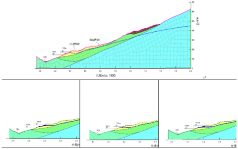
Figure 2. Landslide Seepage Field
According to the calculation and analysis results of the model diagram above, the seepage field in landslide, under the conditions of the change of water level and rainfall capacity at Ou tang landslide, is obtained. From the law of seepage field, each model are in line with the general law of flow, in addition, the seepage field of this landslide is different from usually slope seepage field. It has the following characteristics:
As can be seen by the model diagram, landslide internal, it is the main area of seepage field changes, especially two belt slip, the characteristics and material parameters related to landslide. The landslide zone have good permeability. Rock bottom have low permeability.
The rainfall have obvious effect on landslide. From the point of view of each analysis case, with the fall of the water level, if there is heavy rainfall, landslide rear of the rising water level. The hydraulic gradient and seepage force in landslide increased.
Landslide leading edge by the impact of reservoir water level fluctuation, when the water level lowered from the high level to the low water level, landslide in water seeping from the inside to the outside. Model seepage slope of the curve is in decline, because the overall permeability of the landslide good, the slope of the decline is not obvious. And there is a lag phenomenon, after a certain time starts gently; When the water level rose to a high level by the low water level, the main internal water infiltration from Landslide Landslide external, seepage line inside the landslide slope is in decline. After a certain time becomes more gradual.
(1) Calculation principle of Model
Aiming at different mechanical models, the methods to calculate the landslide stability is different. The methods, used to analyze the landslide stability, mainly contain limit equilibrium method, finite element method, discrete element method and probabilistic analysis. Currently in the field of engineering practice, because of the convenient calculation, the limit equilibrium method is largely applied.
Mainly analyzing the landslide stress and deformation characteristics, the methods of Finite element and discrete element evaluate the deformation and failure mechanism of landslides. The limit equilibrium method is applied in the calculation method of this model, whose entire calculation process is as follows: firstly observing the specific case of the landslide, assuming the shape of the sliding surface, the rock-soil body with lithostatic stress of failure surface do not have to meet the condition of plasticity, but the slip surface need to meet the condition of plasticity. In a nutshell, the picture is regard as a rigid body, which is not same as the theory of plasticity, whose every point of calculation must meet the condition of plasticity.
When we analyzes and evaluate the landslide stability, the first step is to determine the position of the slide surface, the shape of slide surface can be any type; secondly, based on the determined slip surface, to get the limit sliding resistance force of landslide. Since the shape of the sliding surface is hypothetical, the results and stability may be quite arbitrary, and there will be a big difference from the real situation. According to the safety factor, when the minimum value is selected, the corresponding destroy surface is the most dangerous slip surface.
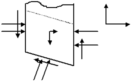
The force diagram of vertical bars is as follows:
$k_{s}=\frac{\text {stabilizing force}}{\text {sliding force}}$
For each slice of the division, the three directions of which can be deduced to three equations, and the three equilibrium equations are:
${{x}_{1,2}}\,=\,\frac{-b\pm \sqrt{{{b}^{2}}-4ac}}{2a}$ (4)
$\sum X_{i}=0$ which is $E_{i}-E_{i+1}+U_{i}-U_{i+1}+\left(N_{i}+\right.\left.U b_{i}\right) \sin \alpha_{i}-S_{i} \cos \alpha_{i}+Q_{i}=0$ (5)
$\sum Y_{i}=0$ which is $T_{i+1}-T_{i}+S_{i} \sin \alpha_{i}+\left(N_{i}+\right.\left.U b_{i}\right) \cos \alpha_{i}-W_{i}=0$ (6)
$\sum M_{(0)}=0$ (7)
And slip surface of each block satisfied destruction of the equation Coulomb – Moore (the formula (5))
$S_{i}=\left(N_{i}+U b_{i}\right) \frac{\tan \varphi_{i}}{F_{s}}+\frac{C_{i}}{F_{s}} L_{i}$ (8)
According to the force diagram can be drawn, when calculating the i-th slice of the sliding body, suppose we are known as a slice of gravity G, Horizontal forces of $\gamma$, hydrostatic pressure F acting on the earth strip, and the bottom of the pore water pressure U. If there is water flowing through the slippery surface, the hydrodynamic pressure is also known. When we assume a landslide slip surface, the slide should face physical and mechanical parameters, geometric parameters are known. To obtain stability factor, equilibrium condition equation, we need demand out of the unknowns, interaction between the soil strips, each vertical bar vertical force and other slippery surfaces. Assuming of course that the position of slip surface shape is not arbitrarily set, landslide must meet the general rule. Introducing the remaining assumptions must also be coordinated and comply with the law.
(2) Calculation method
In this paper, the stability of the calculation method using Morgenstern - Prince method, Introducing seep / w calculated in different conditions of landslides saturation line. The calculated results into slope / w, in order to calculate the stability.
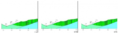
Slope stability analysis model based on previous seep / w model, here we do the quantitative calculation. In this section consider the calculation condition and calculate three conditions, they are: ⅠLandslide leading edge of the water level of the Yangtze River 175m down 145m; ⅡDaily rainfall 144mm (Storm), landslide leading edge of the water level of the Yangtze River 175 drop 145m; ⅢLandslide leading edge of the water level of the Yangtze River 145m liters 175m, in this paper select these three conditions are slippery body is to take a natural landslide, select seep / w calculated on the three cross-sectional sectional. Set level Slope / W module three conditions of the rise and fall times is the same to the down time within the Seep / W module. The figure 3 shows that the tability curve of each condition(Figure 4).
Figure 3. Landslide stability
Figure 4. Landslide stability curve
(3) Stability calculation and evaluation
State landslide stability coefficient can be divided into four degrees, Grade I K<1.00 Unstable; Grade II 1.00<K≤1.05 Less stable; Grade III 1.05<K≤Fst Basically stable; Grade IV K $\geqslant$ Fst, stable. According to “Control engineering geological survey technical requirements”, Stability against sliding safety factor, Fst=1.25/1.20.
According to the analysis of cross-section, according to the stability of the section above graph, we can evaluate the stability of the whole landslide follows:
Overall depth deformable body is a less stable state; the second ordinal landslide in a substantially stable state; local shallow plasmodium: West plasmodium (That is II-II’ sectional portion corresponding) is less stable state, Eastern plasmodium (That is the yellow part IX-IX’ corresponding sectional Pro library), belong basically stable - less stable state.
Landslide stability computing based on numerical simulation, it can be combined with actual monitoring data and evaluation of the actual survey. Landslide risk assessment but also to provide an idea, the same can be combined with practical engineering activities it provides a basis for the construction.
This work is supported by the CGS of P.R.China geological survey project No. 1212011220169, No. 12120113011100.
[1] Huang Runqiu, Xu Qiang and Tao Lianjin. “Studies of process simulation and its control of geohazards,” Beijing: Science Press, 2002.
[2] Huang Runqiu, Zhang Zhuoyuan and Wang Shitian, A Systematic Study of High Rock Slopes, Chengdu: Publishing House of Chengdu &Technology University, 1991.
[3] Schedigger A. E., “On the prediction of the research and velocity of catastrophic landslides,” Rock Mechanics, 5:231-236, 1973.
[4] Huang R. Q. and Zhang Z. Y., “Analysis and mathematic simulation of a large landslide,” In: Balkema A. A., Proceedings of the 7th International Symposium on Landslides, pp. 187-191, 1988.
[5] Sophocleous M. and Perry C. A., “Experimental studies in natural groundwater recharge dynamics: the analysis of observed recharge events,” Journal of Hydrology, vol. 81, pp. 297-232.
[6] Sorman A. U. and Abdulrazzak M. J., “Infiltration recharge through wadibeds in arid regions.” Hydrol Sci J, vol. 38, no. 3, pp.173-186, 1993.
[7] B. B. Broras, Landslides, Foundation Engineering Handbook, Van Nostrand Reinhold Company, 1975.